
基于交通可达性与城市竞争力的城市腹地范围识别——以长江中游城市群为例
|
曾冰(1986—),男,江西九江人,博士,讲师,主要从事经济地理学研究,(E-mail)515881769@qq.com。 |
收稿日期: 2019-06-01
要求修回日期: 2019-09-02
网络出版日期: 2020-02-24
基金资助
国家自然科学基金项目(71703061)
江西省教育厅科技项目(GJJ190285)
版权
Recognition of Urban Hinterland Based on Transportation Accessibility and Urban Competitiveness: A Case Study on the Middle Reaches of the Yangtze River
Received date: 2019-06-01
Request revised date: 2019-09-02
Online published: 2020-02-24
Copyright
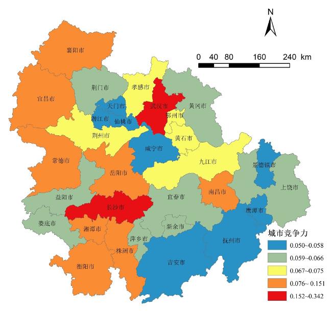
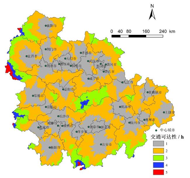
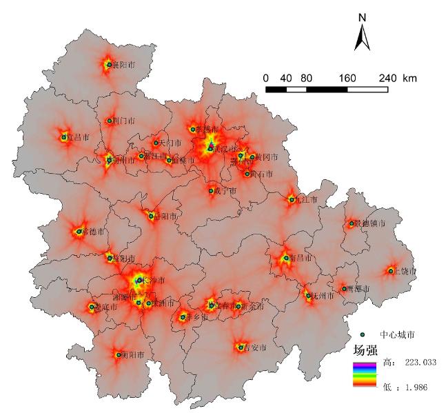
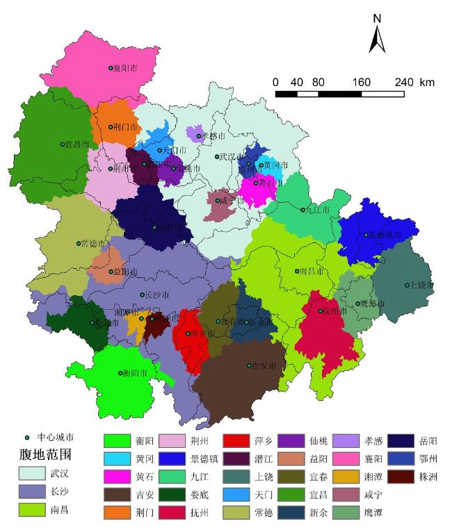
通过构建相应指标体系,采取主成分分析法测度长江中游城市群城市竞争力。在GIS软件支持下,基于时间成本距离栅格的交通可达性分析,利用场强模型,对2015年长江中游城市群31个城市腹地范围进行识别。研究发现:长江中游城市群城市竞争力空间分布差异较大,最大值和最小值相差达5.84倍,与行政级别具有一定关联性。从交通可达性来看,1 h圈空间范围主要集中在中心城市附近,≥3 h圈主要分布在远离省会城市的外围地区,以及岳九咸(岳阳、九江和咸宁)省际交界区。长江中游城市群城市间交通发展缺乏统一规划与协调性,内部交通联系较为薄弱。从空间场强来看,高场强区集中于中心城市及其周边地区,低场强区分布于交通通达性较差的边缘与外围地区,尤其是省际边界地区。场强空间分布与城市竞争力与交通可达性分布具有较强的吻合度,但省际间协同发展程度低。城市腹地范围来看,湖北省大部分城市腹地面积较小,江西省城市腹地面积相对广阔,湖南城市腹地面积居中,三大省会城市腹地面积远超过其他城市,意味着长江中游城市群业已形成以省会城市为多中心的复合型极核发展格局,但内部一体化程度偏弱。从腹地与行政范围的层叠结果来看,城市腹地与市域行政范围吻合度较差,省会城市扩伸率要高于其余城市,而且三大省会城市的域外腹地面积比例远高于其他城市,九江、岳阳、宜昌、常德、新余、景德镇等地域外腹地面积比例也较高。总体来说,长江中游城市群仍停留在子圈内一体化的阶段,还未实现三圈融合和高度一体化发展阶段。
曾冰 , 张艳 , 胡亚光 . 基于交通可达性与城市竞争力的城市腹地范围识别——以长江中游城市群为例[J]. 热带地理, 2020 , 40(1) : 119 -127 . DOI: 10.13284/j.cnki.rddl.003177
Through the construction of a corresponding index system, the competitiveness of cities in the middle reaches of the Yangtze River in 2015 was measured using principal component analysis, and based on their road traffic layers, the accessibility of cities was measured using GIS grid cost distance spatial analysis technology. Then, the entire spatial field strength was simulated using the field strength model, and the hinterland of the cities was extracted according to the maximum principle. This was done to effectively define the spatial scope of the urban agglomeration in the middle reaches of the Yangtze River. The spatial distribution of urban competitiveness in the middle reaches of the Yangtze River was found to be quite different, and the difference between the maximum and minimum values was 5.84, which is related to the administrative level. In terms of accessibility, the 1-h circle mainly concentrates in the vicinity of the central part of the city, and the 3-h circle and above mainly distributes in the periphery far from the provincial capital city as well as in the Yue-Jiu-Xian provincial boundary area. There is a lack of unified planning and coordination regarding inter-city traffic development in the middle reaches of the Yangtze River, and internal traffic links are relatively weak. Regarding spatial field energy, the high field energy area was concentrated in the central city and its surrounding areas, while the low field energy area was distributed in the marginal and peripheral areas with poor traffic accessibility, particularly in the provincial border areas. The spatial distribution of field strength was in good agreement with the distribution of urban competitiveness and traffic accessibility; However, the degree of inter-provincially coordinated development was low. From the perspective of urban hinterlands, the hinterlands of most cities in Hubei Province are smaller, the hinterland of Jiangxi Province is relatively vast, the hinterland of Hunan City is medium sized, and the hinterland of the three provincial capitals is much larger than those of other cities, which means that the urban agglomeration in the middle reaches of the Yangtze River has formed a complex polar nuclear development pattern with the provincial capital cities as the multi-center However, the degree of internal integration is weak. From the overlapping results of the hinterland and administrative scope, the consistency between the urban hinterland and the municipal administrative scope is poor. Cities with an expansion rate that is greater than 1.1 were mainly Wuhan, Changsha, Nanchang, Yichang, Changde, Pingxiang, Xinyu, Jingdezhen, and Yingtan. Cities with an expansion rate above 0.9 and less than 1.1 mainly included Hengyang, Loudi, and Yueyang. In Xiangyang, Tianmen, and Qianjiang, the expansion rate of other cities was less than 0.9. In addition, the proportion of extraterritorial hinterland of the three major provincial capitals was found to be much higher than that of other cities. The proportion of extraterritorial hinterland of Jiujiang, Yueyang, Yichang, Changde, Xinyu, and Jingdezhen was also higher. Generally, urban agglomeration in the middle reaches of the Yangtze River has stayed consistent at the stage of integration within the sub-circle and has not yet realized integration of the three circles or highly integrated development. This study attempted to identify the spatial range of urban agglomerations by using GIS quantitative analysis technology, and we provide reference for optimization and integration of the urban spatial structure of urban agglomerations in the middle reaches of the Yangtze River.

表1 城市竞争力评价指标体系Tab.1 Urban competitiveness evaluation index system |
| 一级指标 | 二级指标 |
|---|---|
| 经济发展 | 人均GDP/元 |
| 人均社会消费品零售总额/元 | |
| 人均固定资产投资/元 | |
| 城镇居民人均可支配收入/元 | |
| 农村居民人均可支配收入/元 | |
| 产业结构 | 第二产业占比/% |
| 第三产业占比/% | |
| 高新技术产业增加值/万元 | |
| 开放程度 | 人均实际利用外资/美元 |
| 进出口总额/万美元 | |
| 移动电话用户数/万人 | |
| 互联网宽带用户数/万人 | |
| 支撑环境 | 授权专利数/项 |
| 普通高等学校在校学生数/人 | |
| 年末金融机构各项存贷款余额/万元 | |
| 一般公共财政预算支出/万元 |
表2 栅格通行速度与时间成本Tab.2 Grid speed and time cost |
| 道路类型 | 通行速度/(km·h-1) | 时间成本/min |
|---|---|---|
| 高铁1 | 300 | 0.2 |
| 高铁2 | 200 | 0.3 |
| 普通铁路 | 120 | 0.5 |
| 高速公路 | 120 | 0.5 |
| 国道 | 80 | 0.75 |
| 省道 | 60 | 1 |
| 县道 | 50 | 0.83 |
| 其他 | 6 | 10 |
| [1] |
|
| [2] |
邓羽, 刘盛和, 蔡建明, 兰肖雄 . 2013. 中国中部地区城市影响范围划分方法的比较. 地理研究, 32(7):1220-1230.
[
|
| [3] |
关兴良, 方创琳, 罗奎 . 2012. 基于空间场能的中国区域经济发展差异评价. 地理科学, 32(2):1055-1064.
[
|
| [4] |
郭丽敏, 周廷刚, 苏迎春 . 2014. 基于加权Voronoi图的城市腹地界定方法研究——以成渝经济圈为例. 地球信息科学学报, 16(3):411-417.
[
|
| [5] |
|
| [6] |
韩艳红, 陆玉麒 . 2014. 基于时间可达性的城市吸引范围演变研究——以南京都市圈为例. 人文地理, 29(6):95-103.
[
|
| [7] |
李凯, 刘涛, 曹广忠 . 2015. 中国典型城市群空间范围的动态识别与空间扩展模式探讨. 城市发展研究, 22(11):72-79.
[
|
| [8] |
刘金石, 李小江 . 2013. 中国城市竞争力指数测度及其影响因素——基于1990—2012年中国30个城市面板数据的实证研究. 财经科学,( 8):92-100.
[
|
| [9] |
梅志雄, 徐颂军, 欧阳军 . 2012. 珠三角城市群城市空间吸引范围界定及其变化. 经济地理, 32(12):47-52,60.
[
|
| [10] |
梅志雄, 徐颂军, 欧阳军 . 2014. 珠三角公路网络可达性空间格局及其演化. 热带地理, 34(1):27-33.
[
|
| [11] |
倪鹏飞, 刘高军, 宋璇涛 . 2003. 中国城市竞争力聚类分析. 中国工业经济,( 7):34-39.
[
|
| [12] |
宁越敏, 唐礼智 . 2001. 城市竞争力的概念和指标体系. 现代城市研究,( 3):19-22.
[
|
| [13] |
潘竟虎, 戴维丽 . 2017. 基于网络分析的城市影响区和城市群空间范围识别. 地理科学进展, 36(6):667-676.
[
|
| [14] |
潘竟虎, 刘伟圣 . 2014. 基于腹地划分的中国城市群空间影响范围识别. 地理科学进展, 29(3):352-360.
[
|
| [15] |
彭建, 陈云谦, 胡智超, 魏海 . 2016. 城市腹地定量识别研究进展与展望. 地理科学进展, 35(1):14-24.
[
|
| [16] |
邱岳, 韦素琼, 陈进栋 . 2011. 基于场强模型的海西区地级及以上城市影响腹地的空间格局. 地理研究, 30(5):795-803.
[
|
| [17] |
|
| [18] |
唐路, 薛德升, 许学强 . 2003. 1990年代以来国内大都市带研究回顾与展望. 城市规划学刊,( 5):1-5.
[
|
| [19] |
王丹丹, 郭建科, 李博, 王绍博, 彭飞 . 2016. 辽宁省交通网络演变对城市腹地分化的影响研究. 干旱区资源与环境, 30(8):88-93.
[
|
| [20] |
文玉钊, 钟业喜, 黄洁 . 2013. 交通网络演变对中心城市腹地范围的影响——以江西省为例. 经济地理, 33(6):59-65.
[
|
| [21] |
吴爱芝, 李国平, 孙铁山, 张冰雪 . 2012. 北京世界城市区域的空间范围划分研究. 城市发展研究, 19(1):64-69.
[
|
| [22] |
姚士谋, 陈振光, 朱英明 . 2006. 中国城市群. 合肥:中国科学技术大学出版社, 5-7.
[
|
| [23] |
赵丹, 张京祥 . 2012. 高速铁路影响下的长三角城市群可达性空间格局演变. 长江流域资源与环境, 21(4):391-398.
[
|
| [24] |
中国交通运输部公路局. 2014. 公路工程技术标准(JTG B01-2014). 北京:人民交通出版社.
[ Ministry of Transport Highway Bureau of China. 2014. Technical Standard of Highway Engineering (JTG B01-2014). Beijing: China Communications Press. ]
|
| [25] |
中国国家铁路局. 2014. 高速铁路设计规范(TB10621-2014). 北京:中国铁道出版社.
[ China National Railway Administration. 2014. The Design Code of High Speed Railway(TB10621-2014). Beijing: China Railway Press. ]
|
| [26] |
中国国务院. 2019. 长江中游城市群发展规划.(2015-04-13)[2019-05-10].
[ China’s State Council. Development Planning of Urban Agglomeration in the Middle Reaches of the Yangtze River.(2015-04-13)[2019-05-10].
|
/
| 〈 |
|
〉 |