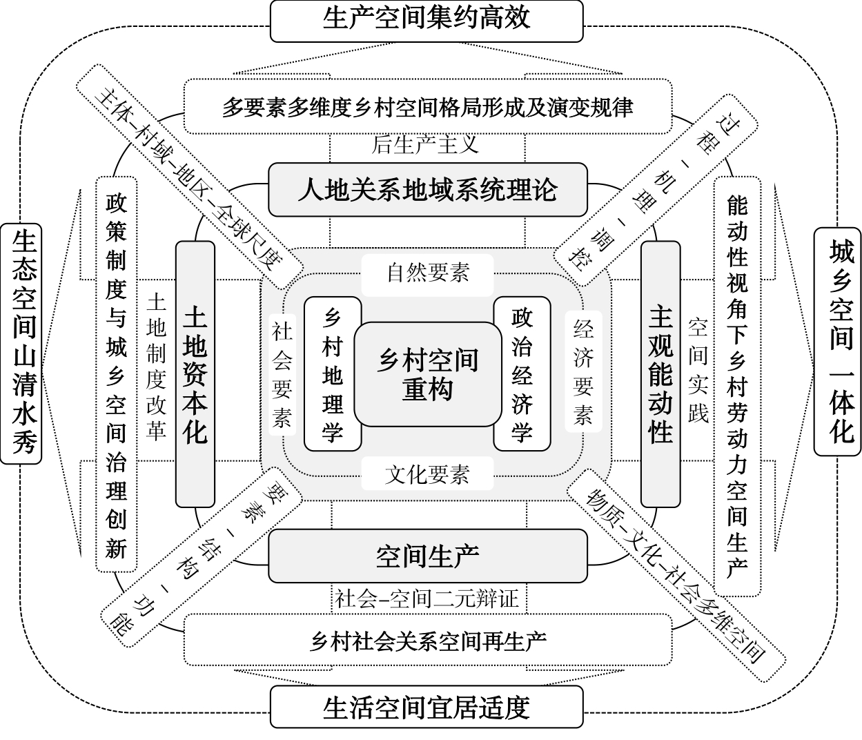
Against the background of urban-rural integration and the increasingly complex human-land relationship in rural areas, rural spatial restructuring has emerged as an important subject in rural geography. This article preliminarily defines the connotation of rural spatial restructuring. It examines and reviews the theoretical research progress in the field of western post-productionism, domestic rural territorial system, and political economy. In addition, the article also constructs a multi-perspective, multi-element, multi-theoretical framework of rural spatial restructuring. The research shows that first, in the context of western "post-productivism," as the study of the rural spatial restructuring begins to demonstrate the consumption, social-cultural and post-modern turns, the research on multi-function, global rural transformation, and spatial reconstructing becomes the focus area. Second, based on the territorial system of human-environment interaction of rural geography, domestic research emphasizes the process-mechanism-regulation of rural spatial reconstructing and farmers' economic spatial behavior from the micro perspective. Third, accompanied by land capitalization and the increasing importance of rural labor mobility, rural spatial reconstructing presents the Chinese characteristics of top-down political and economic transformation and focuses on the space-power relationship between rural collective organizations and other subjects, such as governments, enterprises, individuals, etc. This has become an important perspective of rural spatial reconstructing. Fourth, the political and economic geography and "social-spatial" dual dialectics provide good research paradigms and methods. Moreover, the theoretical study of rural space reconstructing should systematically integrate political and economic theories (spatial production, subject initiative, land capitalization, social relation network, the territorial system of human-land interaction, and peasant household geography) and strengthen the studies on multi-factor interactions and their spatial response mechanisms (nature, economy, society, and culture). To achieve this, the formation and evolution of rural spatial pattern with multi elements and multi dimensions, rural social spatial reproduction, rural labor spatial production from the perspective of initiative, government policy system, and finally, the innovation of urban and rural spatial governance system should be emphasized.
Considering the debate between place and placelessness research brought about by globalization, scholars discuss their views around the simple relationship of "local-global" duality. However, existing research focusses on the powerful class characterized by wealth, ignoring the role of the general public as the disadvantaged group in the dual evolution of place and placelessness. In response to this problem, this study adopts a qualitative research method to conduct a content analysis on the online comments of Chinese and foreign tourists on local food in Hong Kong. The study's findings indicate the following. First, the experience evaluation of tourists shows that whether it is the innovation of food products, a diversified decoration of the dining environment, or the content and form of restaurant services, Hong Kong food culture reflects the integration of Chinese and Western cultures. Further, it has assimilated Western culture to adopt innovations while retaining traditional Chinese characteristics. The coexistence of place and placelessness shows that through globalization, tourists not only want to experience the new and exciting "place" of their target destination. They also need a standard "placelessness" that provides them with a sense of security and comfort. In this process, place and placelessness tolerate, transform, and promote each other and even generate new local products with global attributes. The counter-effects to globalization are reflected through such a process. That is, place and placelessness are not—as many scholars worry—being penetrated by globalization, but rather both can be transformed into each other, and then react to and redefine globalization. This is how a locality presents new cultural connotations in the process of constant internal and external interactions, thereby forming a "new locality," and global forces reconstruct the local meaning. Second, different from wealth, power, and culture, the influence of factors such as the community play a significant role in the process of globalization. People, particularly tourist groups, have a direct influence on wealth and power through consumer choice and the power of the culture subject gaze. The public's adherence to the place will have a direct impact on wealth and power through huge consumer demand, which will guide the protection and creation of local elements. This is the key to the formation of "global significance." On the contrary, globalization can produce a homogenized value identity that transcends the boundaries of the nation-state and then creates a universal standard space with placelessness. In this space, mass groups of different cultural backgrounds can quickly develop a sense of identity and comfort, which is relatively more helpful in ensuring the quality of consumer experience for such groups that rapidly travel worldwide. As previously mentioned, place and placelessness in the tourism space can be transformed into each other, and the process of transformation primarily depends on the value and meaning construction of the place by tourists in the subject's gaze. At the same time, different results will be produced due to differences in various social groups and cultural backgrounds. Nevertheless, globalization is reducing this cultural difference.
Recent research on feminist geography has focused on the human body's micro-geography, identity, and symbolic space. This study primarily concerns the logic of female behavior in small-scale consumption spaces, interpreting such a space's cultural significance and social construction from a gender perspective, analyzing its symbolic significance to feminism, and exploring the power and control that result from such behavior. This study focuses on the praxis and logic of women's lives from a feminist perspective. Starting from a broad perspective of group consumption, including women's spatial perception and cultural experience, it conducts an empirical investigation into the typical attributes of this consumption space and the attributes of space, gender, and power in relationships determined by gender factors. In conclusion, the characteristics of a gender-constructed model of human-earth interaction are summarized. The study helps make good the deficiency of empirical research on small-scale consumption spaces and deepens the research on identity representation and female behavior's cultural connotations in spatial practice. The construction of the consumption space is not only the result of a general social reproduction, but is also the product of gender reproduction. Research on the consumption space from a gender perspective could generate ideas and choices for constructing and reshaping a new public space in the current urban renewal environment. Simultaneously, it is beneficial to women's social relationship status and society's harmonious development. The research results suggest that a gender-aware consumer space could provide a micro-ecosystem for women to participate in an urban setting and call to mind feminist awakening and the practice of women's rights. However, in reality, socially and culturally, women are still disciplined and controlled by males. The behavior of modern women in the consumption space follows the traditional course of role orientation. Women's activities are mainly concentrated in a consumption-driven domestic environment. Their involvement in public space does not significantly change their gender roles or the gender division of labor and their domestic responsibilities. Typical observable discriminatory gender relationships and status are constructed and reproduced in the consumption space, actively confining women to inequality. Therefore, space and gender represent an inseparable dichotomy, and consumption spaces re-enact these unequal gender power relations, reflecting the dominant and controlling relationship between men and women in geographical space.
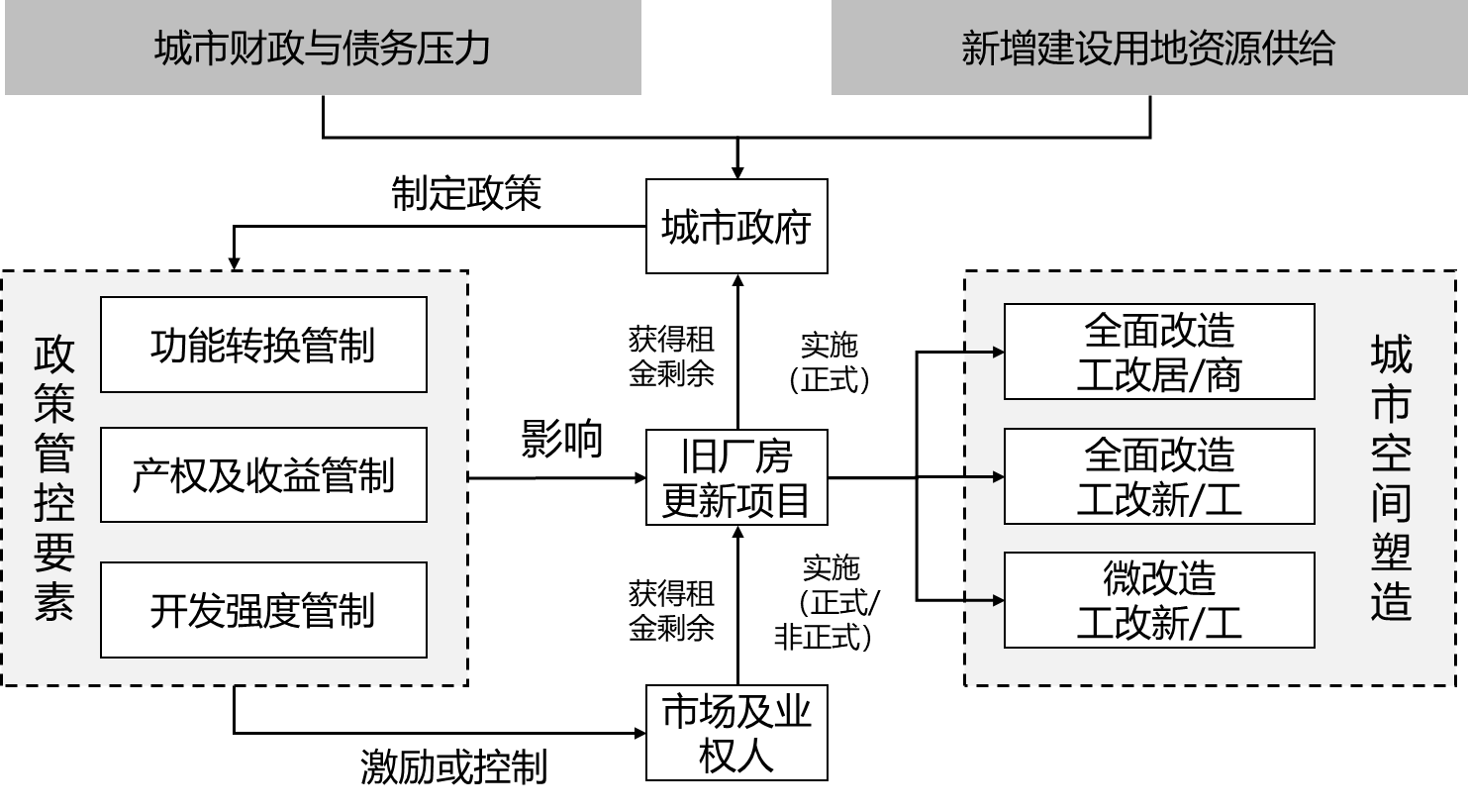
According to the land rent theory, innovative activities return to a megacity's downtown based on the formation of land rent residual in the area occupied by factories. The city government regularly modifies the regeneration policy to balance the distribution of land rent residual between different principals and supply space for innovation. City governments have different opinions on the distribution of land rent residuals. Therefore, methods of supplying space for innovation and shaping diverse urban landscapes also differ. Since the city government of Shenzhen relies less on land finance than other megacities in China, and it lacks land resources, they regenerate industrial land into innovative space. With less constraint on function transformation, development density, and property rights, the city government gives out much of the land rent residual and supplies several high quality spaces for innovation at a medium-cost. The city government of Guangzhou chooses to acquire massive land rent residuals by regenerating state-owned factories and business areas under financial pressure and debts into residency. However, the land rent residual of village-owned factories can only be extracted from informal regeneration under the strict constraints posed and acquired by the city government, while supplying medium to lost cost innovation spaces of medium and low qualities. Consequently, it is suggested that the Guangzhou government should thoroughly research on existing industrial land where old state-owned factories and village industrial parks are located. Spatial planning and reformation of the city and resolving problems in old village-owned factories for a complete and legal upgradation will provide a decent space for the innovation industry. To ensure enough land and space for the innovation industry, the Shenzhen government needs to employ precaution against over-exploitation of industrial regeneration policy when real estate gets involved.
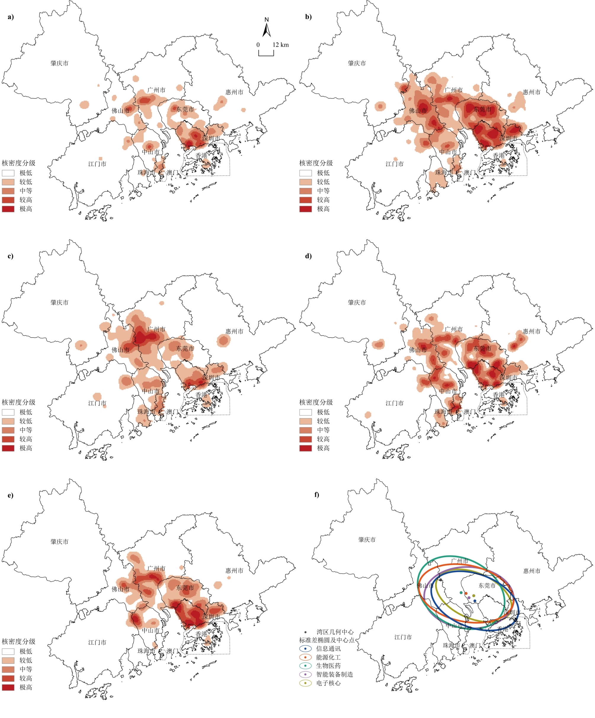
Innovation regularly appears at different venues and areas within cities, and its spatial stickiness has been widely studied and confirmed. However, most current research on spatial innovation has not been conducted in a micro-scale manner to decode the inner-city potentials. From an urban research perspective, this makes understanding the internal clustering mechanism a significant challenge. Thus, this article uses Points Of Interest (POI) data to explore a Scientific and Technological (S&T) spatial index system focusing on innovation potential with a consideration of three dimensions: knowledge, technology, and environment. It analyzes the micro-scale agglomeration structure of the Guangdong-Hong Kong-Macao Greater Bay Area (GBA). First, an inverted U-style innovative core belt embracing the Pearl River in the middle is formed. This area has more substantive innovation potentials on the east than the west coast. Guangdong-Foshan and Shenzhen-Dongguan innovation clusters are then built simultaneously. In both practice and theory, these research findings are consistent with the metropolitan agglomeration pattern and research on the GBA. Additional results are: 1) A notable cluster effect emerges in the spatial distribution of GBA's innovation potentials. Considering the division of dimension, knowledge-based innovation is likely to be led by Guangzhou and Hong Kong, while technological innovation stretches in strong belt-style spillovers along the Guangzhou-Shenzhen S&T Innovation Corridor. However, there is a dearth of innovation in these incubators' environments, and collaboration between them needs to be drastically improved. 2) The hotspot structure shows characteristics such as node clustering, group linking, and multicenter coexistence, while 16 Innovation-intensive Zones (IIZs) emerged in four distinct innovative pathways. These are knowledge-and-research-based, industry-led, environment-incubated, and comprehensively developed, and being close to rivers and streams are significantly influenced by the hydrophilic clustering effect, with a free and comfortable atmosphere inspiring innovation. Traditional administrative forces also have a significant impact, especially on the peripheral areas where innovative activities rely on government planning and the pull-forces from downtown. 3) From the perspective of industry differences, a robust functional differentiation is spatially mirrored. The innovation of intelligent equipment manufacturing has a strong outward diffusion, and the energy, chemical and core electronic industries display an inward node effect. While biomedicine innovation spreads across the two core areas, it is necessary to strengthen information and communication in a broader region with higher potential. 4) In a micro-scale way, an indistinct boundary shapes the Guangzhou-Dongguan-Shenzhen-Hong Kong innovation corridor. However, the need is still urgent to calibrate the regional imbalance and intensify deeply-integrated innovation in light of the vast spatial differentiation and insufficient cooperation between the east and west coasts, the Pearl River Delta and Hong Kong-Macao, and the central and peripheral areas of innovation development. Based on these issues, it is essential to strengthen the emergence of an innovative environment and integrate it with knowledge-based and technology innovation. The aim is to promote the diffusion of pivotal innovative nodes and then specify the differentiated positions of innovative industries to create a region free from boundary constraints conducive to innovation, communication, and cooperation. Thus, for spatial planning in the GBA, the quest for a higher level of innovative potential is imperative, and the integration of collaborative innovation needs to be pursued vigorously.
Based on a questionnaire survey data of the floating population in six cities in the Pearl River Delta, this paper dynamically divides the generations of the floating population according to the socio-economic background of the birth and growth. The new generation, born after 1988, grew up in the process of following their parents out to work away from their hometown, and was significantly affected by the digital information age. The middle generation, born from 1978 to 1988, is the older group of the new generation, and its demographic characteristics and growth era have transitional properties. The older generation was born before 1978, in consistent with the range of the first generation of migrants. The three generations are compared from the perspective of occupational structure and diversity. The disorderly multi-class Logistic model is used to explore the influencing factors of the occupational system. Based on the results, we establish the following: 1) The overall employment level of the floating population in the Pearl River Delta is not high. Here, as the generation shifts downward, employment becomes more diversified. 2) There are significant differences in the characteristics of the three generations of the floating population. From the old generation to the new generation, the sex ratio tends to be balanced, and the proportion of single floating population increases, in addition, working experience is reduced while education level is improved. The degree of job security and monthly salary show an "inverted U-shaped" intergenerational distribution. 3) The overall floating population is concentrated in services and manufacturing, and low-end service, production, construction employment are the most common employment options. The new generation has advantages in technical jobs and corporate clerical profession. The middle generation employment in different industries is relatively balanced, and managerial employment is relatively high. The older generation is mostly confined to the basic sector dominated by manual labor. 4) There are similarities and differences in the influencing factors of the intergenerational occupational structure. The common factors are education, monthly salary, and gender. The time spent working away from hometown has a positive impact on the service-oriented and management-oriented employment of the new generation. Occupations with a stable working environment are more attractive to the married new generation, and the middle generation is more sensitive to household registration and job security factors. 5) To improve the employment status of the floating population, this paper discusses the population employment policy: On one hand, facing different intergenerational employment characteristics, the new, middle, and old generations are supplemented with guiding, encouraging, and supportive employment policies. On the other hand, focusing on influencing factors, the government should continue to promote the reform of the household registration system, support the development of education, and guide women's employment and self-employment. 6) The article made a new attempt to classify the original intergenerational classification, which improved the timeliness of the intergenerational division of the floating population. But the study is limited to a specific time section. In the future, previous employment experience and future employment desire of the floating population can be taken into consideration to enhance the continuity and pertinence of intergenerational employment research.
Consequential to socio-economic development, the middle class in china has grown considerably, gradually becoming an important social group. With rapid urbanization and constant suburbanization, the emergence of middle class exerts a profound impact on the gentrification and housing choices in a country or region, contributing to the urban social space reconstruction. According to the previous research, the middle class social area is expanding in Guangzhou, with evident suburbanization and centralization. The middle class social area in Guangzhou can be divided into four subtypes according to their changing condition: stable, unstable, decaying, and growing. What is the cause of this phenomenon? What are the main features of housing demand, or the willingness to pay for a residential location, and what affects the middle class' behavior in the microcosmic aspect? What are the similarities and differences of the middle class' housing location choice behavior in Chinese and Western societies? This study primarily analyzes the middle-class's housing location choice behavior from the perspective of housing demand and residential location selection, based on the questionnaire survey of 24 sub-districts in 50 middle-class neighborhoods of Guangzhou in 2014 and using the multinomial Logit model. The results show that first, the middle class's housing location choice presents centralization. Second, residential conditions (living space per capita, the current residential location, age of the current settlement, length of residency), family life cycle (such as age, family size, number of children), and economic performance (annual household income, annual personal income, number of private cars) have significant impacts on housing demand. Third, family life cycle (age, family size) and individual factors (educational level, registered residence) have a marked impact on housing location choice behavior. Generally, institutional, location, and individual factors have a combined effect on the middle class's housing choice behavior. Furthermore, this paper analyzes the differences and similarities in the influence factors of middle class's housing location choice behavior on resident's housing demand by comparing Chinese to Western societies. In western societies, children's education is the chief reason for housing choice, followed by commuting time. However, in China, the influence factors are exactly the opposite: commuting time followed by children's education. Regarding the housing location choice, the middle class's housing location choice shows centralization in China. On the contrary, for most western middle-class families, moving to the suburbs seems like a logical step to take once they have children.
The south hilly and mountainous area is an important ecological functional area in China. As the main economic activity subject, farmers' perception of ecosystem services directly affects the eco-environment behavior, economic production activities, social life style and so on. The contribution of well-being is the core of ecosystem services. In order to explore the relationship between farmers' well-being and ecosystem services and promote the healthy development of ecosystem, eight villages in Lechang city of Guangdong Province, which are located in the key ecological functional areas of hilly and mountainous areas in south China, are selected as the research objects. Based on field survey and questionnaire interview, the structural equation model was used to comprehensively analyze the relationship between the development level of rural communities and farmers' welfare and the changes in ecosystem services, emphasizing the changes in that occurred between 2005 and 2018. The results show the following: 1) From 2005 to 2018, the well-being level of farmers has somewhat improved. The income level and living conditions of farmers have increased significantly; their evaluation values have increased from 0.294 and 0.245 in 2005 to 0.385 and 0.422 in 2018, respectively. Meanwhile, the awareness of farmers on ecological protection has been gradually strengthened. 2) The awareness of the four major service functions of the system is rising; particularly, the degree of understanding of cultural service functions and support service functions has improved significantly. The perceived value of farmers increased from 0.251 in 2005 to 0.370 in 2018. 3) The four service functions of the ecosystem have a certain coupling relationship with the level of community development, among which the relationship between supply services, cultural services and farmers' well-being is close. 4) To enhance the cultural service capacity of the ecosystem and develop the low impact economic development mode is conducive to the maintenance of ecosystem services and the improvement of farmers' well-being, and promote the sustainable development of ecological environment and rural socio-economic in key ecological function areas.
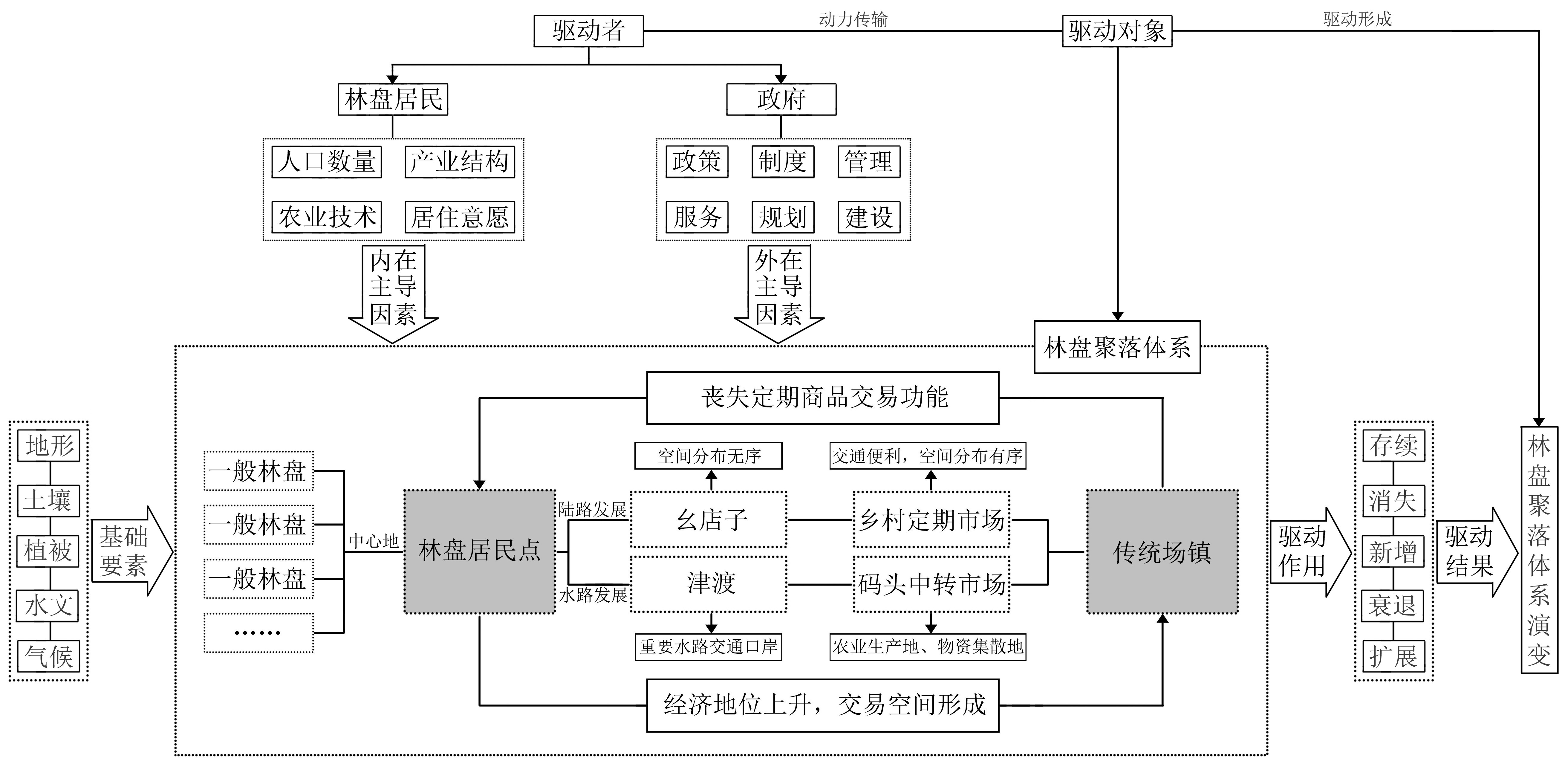
Linpan is a unique, scattered rural settlement in Chengdu Plain. Linpan residents exchange materials and information in the market town, which is the central node of the traditional era. The spatial distribution of traditional market towns and Linpan settlements is developed on the basis of certain natural and social conditions, which are the manifestations of the relationship between man and land in Chengdu Plain. This study took Pi county as an example, as it represents the regional characteristic of Linpan in Chengdu plain. According to modern maps and related geographic information, this study revealed the changes in spatial distribution characteristics of Linpan settlements and the distribution of market towns in Pi County in 1947, 1970, 1985, 2000, and 2018, using GIS spatial analysis, kernel density estimation, Euclidean distance, Gini coefficient, and other methods. The results are as follows: First, there are clear spatial differences in the distribution of Linpan settlements in different periods. From the distribution characteristics of different periods, before economic reforms and liberalization, the distribution of Linpan settlements was affected by its political and economic center. Thereafter, the distribution of Linpan settlements demonstrates the characteristics of homogenization and rapid development. However, the process of urbanization has fundamentally changed the scattered characteristics of Linpan settlements, and its aggregation degree has considerably increased. From the distribution changes over time, the high-density Linpan settlements tend to distribute around the traditional market towns and urban built-up areas. Second, the market radius of the traditional market town is about 3 km, and the traffic condition primarily determines the site selection of the traditional town. Before the end of the Republic of China, the location of the market town was affected by waterway traffic. Afterwards, the transportation convenience introduced by waterway traffic was replaced by land traffic. Third, the equilibrium degree of spatial distribution of traditional market towns in different periods, is in the following order: 1985 > 2000 > 1970 > 2018 > 1947. The distribution of traditional market towns would tend to be balanced with the self-organizing behavior of Linpan residents and the regulation and control of relevant policies. However, because of an increase in policy intervention in the early stage of economic reforms and liberalization, the market town is no longer affected by the spontaneous activities of Linpan residents. The trading space of the market and town has changed from the traditional streets, squares, teahouses, and clubhouse gates to facilities and indoor fixed places. Finally, Linpan settlements are distributed along the river system. In the traditional period, the relationship between Linpan settlements and the major roads was not significant. However, currently, the Linpan settlements are distributed along the road. Based on the comparative analysis of several periods, this study reveals the distribution characteristics and evolution process of traditional market towns and Linpan settlements and discusses the relationship between them. Moreover, this can provide a new perspective for the orderly and healthy development of urban and rural space in Chengdu Plain.
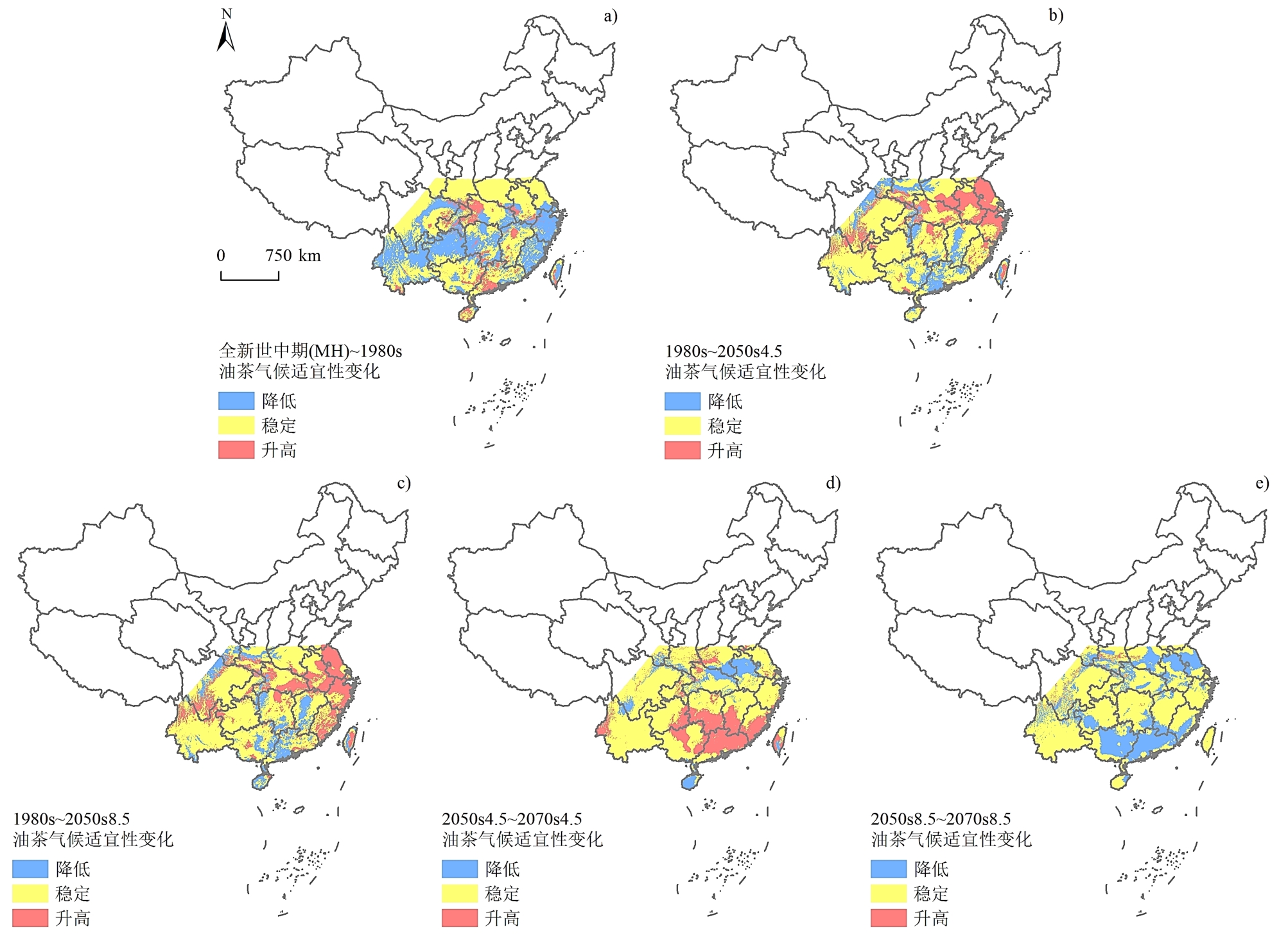
Based on research into climate suitability and employing a species distribution model, this paper examines climatic data from six periods from the mid-Holocene (MH), 1970-2000 (the 1980s), RCP4.5 and 8.5 under 2041-2060 (2050s4.5, 2050s8.5) and 2061-2080 (2070s4.5, 2070s8.5), combined with data from Camellia oleifera specimens. The study uses the MaxEnt model to analyze the temporal and spatial characteristics of the suitability of C. oleifera growth under climate change scenarios. The suitability results are divided into four levels, from low to high, and the spatial distribution changes of the suitability of each transition period, the change of the northern boundary and the geometric center, and the displacement of the most suitable area are analyzed. The results show that: 1) According to the specimens and growth habits, C. oleifera is mainly distributed in the hilly areas of southern China, with latitude and longitude ranging from 18°31' to 33°15' N and 101°34' to 121°51' E, respectively, and the area is mainly in the subtropical East Asian monsoon climatic belt and has plenty of sunshine and heat. 2) The area under the curve (AUC) values of the training data set and the test data set of the MaxEnt model are 0.848 and 0.817, respectively, and the evaluation results reach the "good" standard, so that this model can be used for climate suitability analysis for the growth of C. oleifera. Taking the distribution probability P≥0.35 as the standard, the annual precipitation ≥1 100 mm, precipitation of the wettest quarter ≥550 mm, a mean temperature of the warmest quarter ≥20℃, a temperature seasonality <8.9, precipitation of the driest month ≥15 mm, a mean temperature of the wettest quarter 17-28℃, and a mean temperature of the coldest quarter ≥4℃ are the seven main environmental factors and ranges suitable for the growth of C. oleifera. Their contribution rates are all over 4%, and the cumulative contribution rate reaches 90.1%. 3) The areas with the highest climate suitability for C. oleifera in China are mainly south of the Yangtze River and east of the Yunnan-Guizhou Plateau, with a range of south of 30°N and east of 107°E. In general, the suitable level and above accounted for 34.9%-61% of the study area, and Hunan, Jiangxi, and Guangdong areas are the most suitable. Concerning the suitability changes, the southwest region fluctuates in space, and the most suitable area in the southeast hilly area is relatively stable. The areas of stable type and decrease type account for a relatively high proportion, which is 58.1%-71.5% and 9.3%-33.6%, respectively. 4) The northern boundary of the most suitable region for C. oleifera mainly lies between 24 ° N and 33 ° N in the central subtropical zone, which varied greatly in Qinling Mountains, Chongqing, Guizhou, and Guangxi in different periods. On the whole, it moved to the south from the middle Holocene to the 1980s, and moved northward from the 1980s to the 2050s and 2070s. The geometric center and displacement shifted to the East and North as a whole, and the most suitable center was located in Chenzhou, Hunan Province, in the middle Holocene. In the 1980s, it moved southeast to Shaoguan, Guangdong Province, in the 2050s, it will move northeast to Ji'an, Jiangxi Province, and in 2070s, it will move to the southwest and northeast in the RCP4.5 and 8.5 scenarios, but will still be present in Ji'an. 5) When climate scenario data and the MaxEnt species distribution model are used to analyze the temporal and spatial characteristics of C. oleifera climatic suitability in southern China, the results have a good correspondence with similar research results and China's C. oleifera production statistics. This correlation indicates that the results are reliable and can be used as a reference for C. oleifera planting divisions.
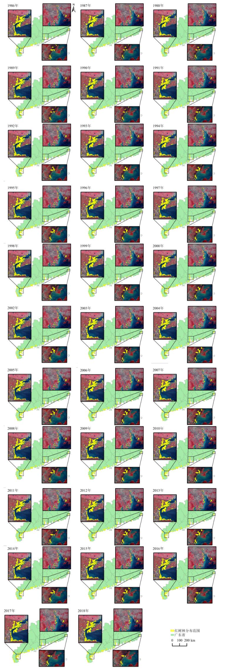
Mangroves have critical ecological functions and social and economic value, and are an important target for protection in the coastal wetland ecosystem. By monitoring long-term dynamic changes in mangrove ecosystems, the overall change process can be systematically and accurately recorded, providing data support and a basis for decision-making on scientific protection and effective management of the ecosystem. This study focuses on mangrove forests in coastal areas of Guangdong Province. A map of the mangrove forest, from 1986 to 2018, was made using Landsat remote sensing image based on Google Earth Engine (GEE),which is a cloud computing platform. The Random Forest (RF) method was used to extract mangrove trees from 32 periods from 1986 to 2018, in Guangdong Province. The interannual variation in mangrove characteristics in coastal cities of Guangdong province were compared. In addition, the evolution characteristics of mangrove patches in Guangdong province were analyzed. The results show that 1) The computing capacity and massive data of the GEE cloud platform provide data support for analyzing the inter-annual evolution of mangroves in Guangdong province, which greatly improves the computing efficiency. From 1986 to 2018, the overall classification accuracy of mangrove remote sensing was higher than 90%, with high classification accuracy and reliable results. In general, the coastal mangrove area of Guangdong province first decreased and then increased, and the range of change gradually declined after 2014, remaining at about 11 000 hm2. Mangrove forests are unevenly distributed in the province and occur mainly in the west. 2) Concerning coastal cities, mangroves are distributed in 14 cities, among which Zhanjiang and Yangjiang have the largest mangrove area, which is about 70% of the mangrove area of Guangdong province. The mangrove area changes in each city fall under three categories: decreasing first and increasing later, increasing fluctuation, and no obvious change. 3) From 1986 to 2018, the overall number of patches in mangrove forests in Guangdong province showed a decreasing trend, but the average patch area (MPS) showedan increasing trend, and mangrove fragmentation was reduced. In 2018, the mangrove MPS was 4.11 hm2 in Guangdong province, and the total number of patches was 2 782. From 1986 to 2018, when the change trend of MPS in mangrove forests in Guangdong province was opposite to that of patch quantity, the changes of patches were mainly expansion and fragmentation. When MPS change trend was consistent with the change trend of plaque number, the increase and decrease in the change of plaque were dominant. Information on annual mangrove area distribution and structural changes can provide more detailed data and reference for the rational development and protection of mangroves and support ecological restoration and finely tuned mangrove management.
Pole-like objects are commonly occurring features on roads, and their identification in photographs is essential to the management and mapping of road information. In particular, mobile laser scanning systems comprise one of the most accurate and efficient techniques to gather road-related geospatial information. The automatic detection and classification of pole-like objects based on the point cloud data gathered by such systems enable significant reduction in costs and improvement in efficiency of mapping functions. This paper proposes a complete, fully automated processing framework that detects and classifies pole-like objects appearing in images of highways and urban streets based on the associated point cloud data. The primary workflow of the framework includes three steps: data preprocessing, detection, and classification of pole-like objects. During data preprocessing, an advanced filtration algorithm is used to automatically separate ground points from non-ground points. Subsequently, the non-ground points are clustered and overlapping clusters are further separated via a collaborative iterative graph cutting algorithm. During object detection, all available information, including shape information and position guidance, are integrated to detect pole-like objects. During object classification, the multiple aggregation levels of features and the contextual features corresponding to each object are calculated and transmitted into a random forest classifier to classify the detected pole-like structures. The proposed method was tested on three road scene datasets. The overall MCC coefficient corresponding to all three datasets was observed to be 95.6% during detection, and the overall classification accuracy corresponding to the three datasets was 96.1% during classification. Further, comparative experiments with respect to existing techniques were conducted, and the results demonstrated that the proposed method significantly improves the recognition of road facilities.
Soil magnetism is an important indicator of soil quality. Spatial distribution and environmental significance of surface soil magnetic properties have been reported from many areas worldwide. Spatial distribution of magnetic parameters was acquired through the spatial interpolation method and data of sampling sites was measured for a specific spatial scale in most of these studies. However, a limited number of studies in this field have appropriately reported on the accuracy of these spatial interpolation methods. Based on statistical characteristics analysis, normality test, and trend analysis, the results of 14 magnetic parameters of 350 surface soil samples collected from Guangzhou city were used to perform several spatial interpolation methods. Geostatistics (including Ordinary Kriging and Universal Kriging) and deterministic interpolation methods (including Inverse Distance Weighting and Radial Basis Function) were employed to conduct the spatial interpolation methods. The accuracy of spatial interpolation methods was measured by cross-validation. Mean Error, Root Mean Square Error, Mean Standardized Error, Root Mean Square Standardized Error and Average Standard Error were used to measure the accuracy of results of geostatistics methods; the optimal spatial interpolation method of each magnetic parameter of Ordinary Kriging and Universal kriging was selected. Next, Mean Error and Root Mean Square Error were used to measure the accuracy of results of deterministic interpolation methods; the optimal spatial interpolation method of each magnetic parameter of Inverse Distance Weighting and Radial Basis Function was selected. Finally, by comparing the Mean Error and Root Mean Square Error of the optimal deterministic interpolation method and geostatistical interpolation method, the optimal interpolation method of each magnetic parameter was determined. The results show that: First, among the geostatistical interpolation methods, the Ordinary Kriging method is effective for spatial interpolation of magnetic parameters χARM, χlf, χhf, S100, S300, S-100, SIRM, and HIRM; spatial interpolation of SIRM/χ should use the Universal Kriging method; Ordinary Kriging and Universal Kriging can be used for spatial interpolation of χARM/SIRM and S-300. Second, in the deterministic interpolation methods, the Radial Basis Function method is an optimal choice for spatial interpolation of χARM, χlf, χhf, χfd (%), χARM/χ, χARM/SIRM, and HIRM; for spatial interpolation of S100, S-100, and S-300, SIRM Inverse Distance Weighting method was the best alternative; Inverse Distance Weighting and Radial Basis Function methods could be used for spatial interpolation of χfd, SIRM/χ, and S300. Third, a comprehensive comparison of geostatistical interpolation methods and deterministic interpolation methods shows that spatial interpolation of χARM, χlf, χhf, χfd, χfd (%), χARM/χ, χARM/SIRM, S300, and HIRM should use the Radial Basis Function method; the Universal Kriging method is suitable for spatial interpolation of SIRM/χ. The Inverse Distance Weighting method should be chosen for spatial interpolation of S100, S-100, and S-300, spatial interpolation of SIRM should be measured with the Ordinary Kriging method.
Taking Guangzhou as an example, Baidu street view images of 6670 sample points in the four central districts of the city were selected as test data to explore the possibility of urban poverty measurement in an urban built environment. Firstly, after training the street view picture-classified model based on FCN-8s deep neural network, the street view features were semantically divided into categories such as buildings, sky, trees, and so on. The street view indicators of communities were calculated by buffer analysis. Four street view main factors including building enclosure, vegetation enclosure, sky openness, and road openness, were extracted by principal component analysis; the correlation between them and multiple poverty index (IMD) was verified. Finally, the multi-linear regression model to estimate the poverty level, which is based on street view indicators, was constructed from 61 communities through a simple random sampling method. The prediction model was used for the remaining 60 communities in order to verify the accuracy of the street view measurement. It was found that IMD is positively correlated with building enclosure, and negatively correlated with vegetation enclosure, sky openness, and road openness. In addition, the measurement results from street view were basically consistent with the spatial patterns of traditional urban poverty measurement, which were usually higher than the poverty level in traditional poverty measurement. This is because the two methods produce different results that are affected by the measurement content, community type, street attributes, and other factors. For example, street view can depict the real living environment of the poor urban people, which is more suitable for poor communities that occupy terribly built environments, such as crowded and dilapidated old neighborhoods, urban villages with serious construction violations, rural homes, and under-construction industrial parks and so on. On the other hand, the traditional IMD measurement method is more suitable for those areas where the external and surrounding built environments are not very bad, such as redeveloped constructions that replaced decaying structures, affordable housing with pleasing environments, and so on. To a certain extent, the two methods can complement each other, and street view can provide timely monitoring of changes in urban built-up areas. It can also help poor communities put forward concrete proposals to effectively improve their living environment, in terms of physical amenities, such as roads, buildings, and green spaces. In this paper, a series of street view indicators related to urban poverty were extracted by analyzing the street view data of communities in the four central districts of Guangzhou. Based on these indicators, a model of urban poverty was successfully constructed. Findings about the characteristics of street view, factors influencing street view measurement, and the scope of application when compared with the traditional urban poverty method are presented. The use of an urban poverty measurement technology with high precision, wide coverage, fast updating, and information-rich streetscapes can benefit and refine urban poverty research and enrich the dimension of urban poverty measurement indicators. Such measurement also has practical significance for the redevelopment of decrepit structures and areas inhabited by poor communities.
The impact of large-scale urban conventions and exhibitions on the spatial differentiation of the hotel industry has always been a topic of interest in the academic community. Existing researches, however, pay more attention to the short-term and static economic patterns caused by certain exhibitions and less to the long-term and dynamic pattern changes caused by the relocation of the exhibition hall. Therefore, this study takes the overall movement of the Canton Fair to Pazhou in the fall of 2008 as an example with which to explore the practical impact of the relocation of its pavilion on the spatial reconstruction of the star-rated hotels in Guangzhou city during the exhibition period. It uses measurement statistics and ArcGIS software to compare data on these hotels during the Spring Fair in 2008, 2012, and 2016, attempting to reveal the changes in and logic behind their revenue trends based on supply of and demand. The main conclusions of the study, in terms of the overall and average revenue of these hotels during the Canton Fair in the eight years after the relocation of the pavilion are as follows. 1) Before the relocation of the exhibition hall, the overall and average revenue of star-rated hotels had "single-core" spatial characteristics, with Yuexiu District as the core; after the relocation, income earned in Yuexiu District gradually decreased while that of Tianhe and Haizhu districts gradually increased, showing that a "dual core" pattern centered on Yuexiu and Tianhe. In addition to this shift, the focus of the revenue saw an "eastward extension". A "southern extension" was relatively consistent with the spatial relocation of the pavilion, which changed the spatial distance between the hotel and the exhibition and triggered the transfer of demand for accommodation and promoted the formation of the "dual-core" revenue pattern for the municipal hotel industry. 2) The fluctuation of hotel revenue in each region from 2008—2012 was greater than that from 2012—2016; and this was smaller in Yuexiu District and the nearby Liwan District, where the exhibition moved to halls that were smaller than those used in Haizhu and Tianhe districts when the exhibition moved to the latter. This indicates that the impact of the relocation of the exhibition hall on changes in hotel revenue has shown a trend moving from large to small over time, and the rate of change in the areas to which it emigrated is less than that from which it immigrated. 3) Simultaneously, however, the growth in the number of hotels near Pazhou are not enough to manage the surge in demand for accommodation during the exhibition, and the hotel supply pattern of the Yuexiu District still dominates the regional competition due to a special hotel purchase mode which ensures that the original demand for accommodation remains there. This inhibits the "dual-core" revenue pattern of the municipal hotel industry from evolving into a "single-core" pattern centered on the new location of the exhibition hall. This will ensure that the overall and average revenue of the hotel industry in Yuexiu District maintains a long-term revenue advantage after the relocation of the exhibition hall.
Since the reform and opening of the economy, China's coastal areas have taken the lead in establishing labor-intensive industrial clusters. These traditional industrial clusters have furthered the rapid development of the regional economy. However, due to massive global changes in the industrial structure, insufficient innovation and "low-end locking" of the value chain in these industrial clusters have become increasingly evident. Most earlier studies explored the local versus global factors in innovation and the upgrading of traditional industrial clusters from a regional perspective, suggesting that innovation in the traditional industrial clusters has a derivative and incremental character, and is embedded in local networks which produce a substantial knowledge spillover. The value added to products improves, yielding a significant competitive advantage and increasing the economic resilience of traditional industrial clusters. With new-generation information and communication technology, geographical and industrial boundaries have become blurred. Traditional industrial clusters have repeatedly presented innovation and transformation modes. More recent studies indicate that experience and knowledge from outside the industrial cluster and cross-industry innovation lead to the elevation of traditional industrial clusters to the high end of the value chain. However, in-depth analyses on the mechanisms and effects of these disembeddeding forces are relatively few. Using Chenghai's toy industrial cluster in Eastern Guangdong as an example, this paper reflects on the formation and effects of the mode of disembedding innovation in traditional industrial clusters. It is found that under the joint actions of market demand, localized innovation networks, external innovation resources, enterprise strategy, and entrepreneurship, the transformation of Chenghai's toy industrial cluster presents two modes. The first is the "non-localized innovation" mode, manifested in the separation between R&D and manufacturing functions. The second is the "cross-industry expansion and innovation" mode manifested in the development of emerging industries or their integration with traditional industries. These innovative practices have had a constructive effect on cluster enterprises and regional economies. They integrate external innovation resources, merging them with their own innovative advantages. They have also established a productive local innovation ecology and promoted independent innovation capacities, raised awareness of the need to protect the intellectual property of enterprises. These practices also strengthen the traditional toy industry and promote the transformation and upgrade of the cluster. Finally, they drive the overall improvement of the regional economies. Therefore, the innovation of traditional industrial clusters can transcend their regional and original industrial boundaries, expanding into a larger spatial scale and industrial scope.