
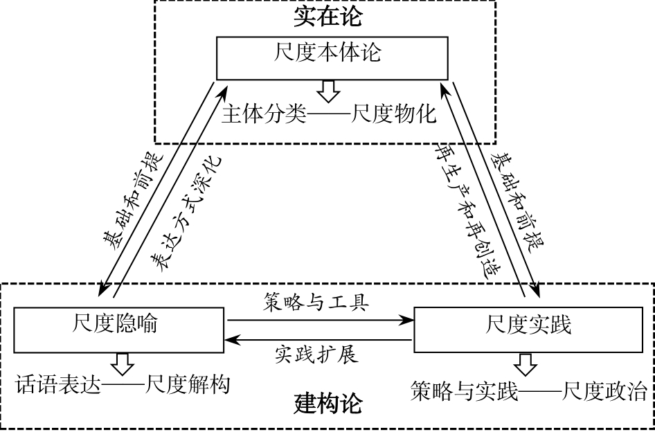
Scale is an important concept in geography. The evolution of scale connotation is closely related to the spatial organizational change in Western capitalist economic activities. With the scale shift of Western human geography, it has changed from being static and bounded by spatial entities to one characterized by process, evolution, dynamic social practices, and discourse representation. The Western scale has led to rapid developments in theory and practical applications. The conclusion of the Western scale is conducive to the dialog with Western scale research and is also of certain significance to formulating Chinese scale research . Taking Web of Science core data sets and Google academic literature as data sources, we retrieve keywords such as "scale" and "politics of scale," download relevant literature, and analyze and summarize it to obtain the background, focus, evolution process, and development direction of Western scale research. By clarifying the connotation and main content of Western scale research, it is found that 1) scale includes three main elements: theorizing scale, rhetoric of scale, and scales of praxis. The ontology of scale holds that it is a static hierarchical structure. The metaphor of scale is embodied in the fact that it can be deconstructed and expressed in a variety of ways through discourse. "Scales of praxis" means that scale is constructed in society through the interaction between different actors to re-create it. 2) There is unity and opposition between the three elements of the measure. In terms of unity, the theorizing scale creates the premise for the rhetoric of scale and the scales of praxis, and the rhetoric of scale and the scales of praxis develop the theorizing scale. In terms of opposites, the theorizing scale is the realist standpoint, while the rhetoric of scale and the scales of praxis are the products of constructivism. 3) The core of scale practice is scale politics, which focuses on the political game between different individuals or groups and emphasizes interests and efficiency, and easily causes negative social externalities and imbalances in resource allocation. It is necessary to introduce a third party to intervene, or regulate politics of scale, to realize the political economy of scale. Western scale research has experienced two typical stages, which have been fiercely debated: A. To materialize the scale into a fixed spatial entity; B. Different actors use scale to carry out social practice or discourse expression. In essence, the two stages are not completely separated in terms of time and main viewpoints. They mainly concentrate on the difference in focus, and there is a relationship between inheritance and complementarity. This indicates that the scale research of Sinicization needs to combine the two—to not only recognize the role of material space entities, but also accept the initiative of actors—and to regard scale as the relationship network of human and material interaction. In the specific application of scale, we should first divide the material spatial entity and scale it, subsequently analyzing the social facts shaped by it; then, one needs to analyze how the actors use discourse expression or political strategies to deconstruct and construct the scale, fully considering the possibility that individual interests infringe on social interests in the scale practice, and introduce the intermediary mechanism to intervene therein. This paper presents the conceptual framework of scale and realizes the induction of the application path of scale, which is embodied in three aspects: scale, scale deconstruction, and scale politics. At the same time, it proposes incorporating the effect of resource allocation into the analysis of scales of praxis to realize the political economy of scale, which not only expands the theoretical connotation of scale, but also increases the practical applicability and scope of scale.
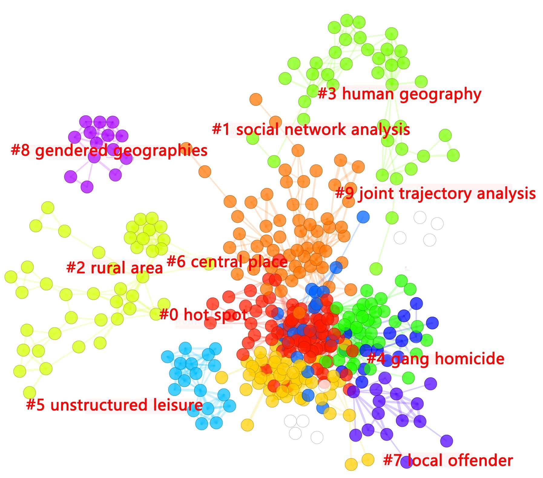
Crime geography, as a new interdisciplinary subject in academia, has attracted extensive attention. Based on the "Web of ScienceTM Core Collection" and CNKI data sources, this study clarifies the thematic structure and development of crime geography in China and abroad by using CiteSpace. Specifically, the study comparatively examines the progress of crime geography studies in China and abroad since 2000 and analyzes future development trends from the time of publication, regional and subject distribution, research institutions, and keyword co-occurrence. We hope that this work provides a relatively complete and objective understanding for innovative future research. The results indicate that from 2000 to 2020, a total of 841 articles were published in the Web of Science across three growth stages—slow, medium, and rapid—with the most of these articles come from USA. For the same period, 160 articles were published in CNKI across two stages—initial exploration and slow development—with a relatively slower growth rate. The subject categories were wide, and cooperation networks among research institutions were stronger abroad. The studies were mainly in the fields of criminology and penology geography, environmental sciences and ecology, urban studies, and social sciences. Domestic subjects were relatively concentrated, and institutional connections were weak. Follow-up research is still in developmental stages. Foreign countries experience various crimes, across micro and macro areas, including violence, terrorism, racial discrimination, and gender discrimination. Crime, criminology & geography, space, place, hot spots, routine activity, and neighborhood were the main keywords in foreign studies, forming three thematic modules: crime distribution patterns; crime prevention and control countermeasures; and crime theory and methodology. Research in China focused on robberies, snatching and theft, child trafficking, and drug crimes, including keywords such as crime geography, crime hotspots, crime mapping, and GIS. The number of empirical studies on this topic is increasing. With the increase in interdisciplinary integration, crime geography has undergone significant development. Crime distribution patterns, spatial prevention and control measures, and crime risk simulations are still popular topics. "3S" technology and big data applications will become two parallel lines in future crime geography research. In the future, we need to examine the geographical environment of crime comprehensively and pay close attention to potential fields within crime geography. The development of information technology and the application of econometric models have brought new opportunities for crime geography. We must strengthen research cooperation among individuals, organizations, and institutional groups, and exchange and share results and experiences based on the current international social environment. It is pertinent to explore diverse crime prevention and control models through a global cooperative approach to address crime challenges faced by different regions.
China's rapid urbanization has contributed to an epidemiological transition from infectious diseases to chronic diseases over the last four decades. The aging of the population has also raised considerable challenges for the sustainable development of China's economy and society. Determining the effects of urbanization on older adults' general health in China is helpful for a more comprehensive assessment of current development in urbanization and to find active interventions to achieve healthy aging. Based on a micro-data sample from the 2010 China population census, nighttime light data, and other statistical data, this study employed two-level logistic regression models to estimate the relationships of the level and rate of urbanization with self-rated health among older Chinese adults on the county-level geographic scale and explore the differences in the health effects of urbanization in different groups of older people. We applied propensity score matching to control for self-selection bias. This study found that (1) the level and rate of China's urbanization have a significant positive correlation with older adults' self-reported health, such that older people living in areas with moderate urbanization and experiencing rapid urbanization are more likely to report good health; (2) those with junior high school education or below and those with local hukou benefit more from urbanization development; (3) after controlling for self-selection bias, the level and rate of urbanization are still positively associated with the self-reported health of older adults. In summary, this study used nationally representative census data covering 2805 counties across 31 provinces to provide a more comprehensive picture of urbanization-health relationships across the country. Longitudinal studies are warranted to determine causality, which may help policymakers and practitioners develop effective interventions to promote older adults' health and healthy aging.
Metro railway is emerging as the optimal choice for residents' daily travel in many metropolitan areas in China, which profoundly affects the spatial-temporal characteristics of the travel mode of residents. Studying the spatio-temporal characteristics of metro traffic flow is of great practical significance for optimizing metro traffic layout and relieving urban traffic pressure. Reported studies have afforded significant achievements in the spatial-temporal characteristics of metro traffic flow; however, there are very few studies on the overall perspective of the station network, and most of them fail to further analyze population differences in using metro systems. In view of these gaps in the existing research, this study has two main objectives: 1) to describe the characteristics of metro traffic from the overall perspective of metro station network, with parameters of traffic flows within the station network, average travel distance (time), and their aggregation features; and 2) to analyze the differentiation of population groups near metro stations for understanding population differences in metro traffic flow. The Origin-Destination (OD) analysis method was used to calculate traffic flow characteristics between different metro stations, including the average travel cost (distance/time) and travel aggregation distance interval. Our results lead to the following inferences. 1) The cumulative proportion of passengers in metro stations along with travel distance show an "S" curve function feature, the average travel cost of metro stations in Guangzhou is approximately 14.04 km (20.48 min), and increase by ~4 km (~5 min) and ~13 km (~10 min) from the central area to the inner and outer suburbs. The average weekend travel costs are slightly higher than that of weekdays: the average travel cost on weekend ranged from 0.03 km (0.06 min) less in the central area to 0.32 km (0.49 min) and 0.64 km (0.77 min) more in the inner and outer suburbs, respectively. Three types of metro stations—those serving external transportation, business offices, and public units—have higher average travel costs. 2) The distance interval of passenger flow concentration in metro stations tends smoothly from the center to the periphery. The travel aggregation distance interval in the entire city is 8.55-26.61 km, with 71.88% passengers aggregated within this travel distance range. The travel aggregation distance interval in the central area and the inner and outer suburbs are 2.74-19.23, 7.49-25.23, and 24.3-46.73 km, respectively, with 78.87%, 71.81%, and 56.55% passengers, respectively. The spatial distributions on weekend and weekdays are almost the same, only with a narrow range of travel aggregation distance interval and smaller proportion of passengers on weekends than weekdays. The station types of external transportation, leisure tourism, and residential areas have higher travel aggregation distance interval and passenger proportion. 3) Population groups like women, elderly, people with college-level education or above, office staff, business people, and service personnel are the main components of metro passengers. The average metro travel distance of different population groups is differentiated, as groups with small travel demand and weak travel ability have short average travel distance, while groups with large travel demand generally have a long average travel distance. Our research contributes to the existing literature mainly in two aspects. 1) Average travel cost, knee point analysis, and travel aggregation distance interval were used to depict the spatial-temporal characteristics of metro traffic flow from the overall perspective of metro station network; this is a supplement and expansion of existing literature mainly based on stations or lines. 2) The differentiation of different population groups helped further optimize the planning, design, and line arrangement of metro systems.
The world's population is growing older, with people over the age of 65 being the fastest-growing age group. In China, population aging significantly affects the building of a moderately prosperous society, while the emergence of the urban-rural inversion phenomenon for population aging increases the difficulty of this challenge. To provide further scientific evidence for the optimal allocation of elderly care resources and the welfare improvement of the elderly population, this study analyzed the spatiotemporal evolution characteristics and driving mechanism of the urban-rural inversion phenomenon for population aging in China at the provincial scale. To this end, it used GIS spatial clustering and multiple stepwise regression models. The results indicated that first, along with the continuous increase in population aging, the urban-rural inversion phenomenon for population aging is becoming evident in China. Before 2000, the aging rate of the urban population was higher than that of the rural population in China. In 2018, the percentages of people over the age of 65 in the total population for urban and rural areas were 10.65% and 13.84%, respectively. Hence, the urban-rural inversion phenomenon for population aging is indeed very obvious. Second, generally speaking, the spatial concentration intensity of the urban-rural inversion phenomenon for population aging presented a "low-high-low" inverted U-shaped variation tendency from 1995 to 2018. The urban-rural inversion phenomenon first appeared in the eastern coastal area. It then gradually expanded to the central and western regions, and eventually evolved into a universal phenomenon nationwide. Additionally, this phenomenon has an obvious characteristic of regional differentiation. The level of urban-rural inversion is high in the eastern coastal area, while it is relatively low in the northeast region. The eastern coastal area is the most economically developed region in China, and it can provide more jobs with higher income to laborers than other regions. Consequently, a large number of young laborers from other regions flocked to cities in the eastern coastal areas to find a better job, which greatly reduced the aging rates of these cities and triggered the urban-rural inversion phenomenon for population aging. In contrast, the economic development of Northeast China has been relatively slow since 2000. It is difficult for the cities of Northeast China to attract immigrants and retain the local young population, which leads to a continuous increase in the aging rate of its urban population. Third, there is a complex, multi-dimensional, and non-linear interaction mechanism behind the urban-rural inversion phenomenon for population aging in China. Population and economic factors are the major driving factors of this phenomenon. The imbalance of social and economic development has formed a geographical difference between regions as well as between urban and rural areas, triggered mass migration movements, affected the demographic structure of urban and rural areas, and led to the urban-rural inversion phenomenon for population aging in China. For western provinces with underdeveloped economies, severe population outflows, and higher levels of rural aging, the phenomenon of "old and poor" in rural areas has become a serious challenge for the successful implementation of rural revitalization and targeted poverty reduction strategies. Further, it has become the key step for building a society that is moderately well-off, with regard to all aspects, in China.
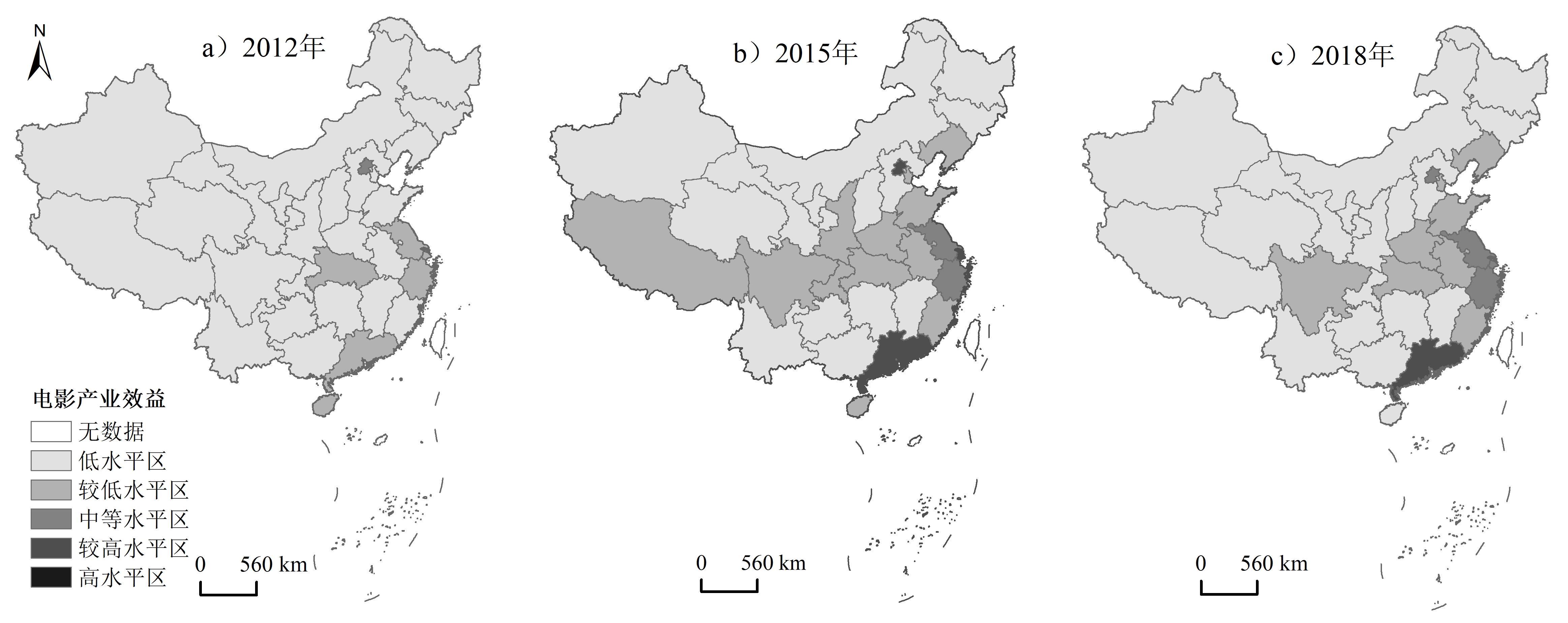
The development of the film industry is among the main ways for countries to promote cultural communication, economic and social transformation, as well as upgrading. In China's film industry, the production, economic, and infrastructure construction scales are rapidly expanding, thus forming rapid growth in economic contributions. The scientific evaluation of the film industry is the basis for the objective study and judgment of its development trends and spatial layout. This paper constructs a comprehensive evaluation index system in three dimensions: the industrial environment, industrial scale, and industrial benefit, using the entropy method to comprehensively evaluate China's 2012-2018 provincial-scale film industry. Through a Geographic Information System (GIS) spatial analysis technology and geographic detector model, this paper discusses its evolution process and regional differentiation law from a spatial perspective. Further, it reveals the impact of geographic space on the film industry, which can provide a reference basis for the formulation of policies related to the spatial layout of the film industry. The results show that although the overall level of China's film industry development was poor in 2012-2018, the development pace has increased significantly. It has formed a high-level area in Beijing, Tianjin, and Hebei with Beijing as the core, a medium-level area in the Yangtze River Delta with Shanghai as the core and Jiangsu and Zhejiang as important components, and a rapid development area in the Pearl River Delta with Guangdong as the core. The "T" shaped space structure is gradually forming, it is obvious for the convergence feature of the development of the spatial and economic development patterns of the film industry. The development environment of the film industry is further optimized, and the overall spatial pattern presents a "concave" character that is high in the eastern and western regions and low in the central region. The scale of the film industry has risen rapidly, forming a pattern of industrial scale in the eastern developed regions higher than that in the central and western regions. The benefit of the industry has increased significantly, and it is increasingly clear that the pattern of spatial distribution is high in the southeast and low in the northwest. The discrepancy of the level of development of the film industry is large among provinces, and the trend of equilibrium evolution is becoming increasingly significant. Further, the film production release and box office revenue are the main reasons for the large difference in the provincial film industry index. The development of the film industry and spatio-temporal evolution are mainly driven by the economic aspect and degree of opening to the outside world. The factors of population, policy, culture, and so on work together. The market-oriented characteristics of the film industry are becoming increasingly prominent, and the market-oriented process is being further promoted. China's film industry needs to conduct a comprehensive construction from the industrial environment, scale, and effect subsystem to form a complete industrial system. By cultivating film and television enterprises, building film and television bases, and creating classic film and television products, we can promote the overall development of the film industry and achieve its industrial functions such as improving residents' artistic literacy and expanding employment. To this end, the support of special cash or funds such as film production and distribution and talent cultivation must be increased. For some underdeveloped areas where it is difficult to achieve the sound development of the film industry through the area's own endogenous power, it is necessary to introduce targeted special policies and financial support. The main academic contribution of this paper lies in providing a description path to explore the evolution process of the film industry from a geospatial perspective, and reveal the regional differentiation law of China's film industry. Finally, it serves to quantitatively characterize the driving factors of the evolution of the spatial pattern of China's film industry.
The consumer service industry directly provides residents with material and spiritual living consumption services and products to meet residents' consumption needs. The reasonable spatial layout of the consumer service industry is of great significance for improving residents' quality of living, optimizing the urban spatial structure, and alleviating urban problems. Based on consumer service point of interest (POI) data, mobile phone signaling data, and population data from Shenzhen, using the nearest neighbor index, kernel density, and entropy index methods, this study analyzes the spatial pattern of the overall and different types of consumer service industry as well as the spatial characteristics of the degree of mixing in the consumer service industry in Shenzhen. Using the Geodetector method, this study also detects the impacts of seven factors, including population, traffic, economy, and space dimensions, on the overall and different types of consumption service industry as well as analyzing the impacts of population age structure on the spatial pattern of this industry and its types. This study is expected to provide a theoretical and decision-making basis for urban planning and development in Shenzhen and other cities. The results show that: 1) The spatial distribution of the consumer service industry in Shenzhen is unbalanced and is concentrated in the central and western regions. The consumer service industry presents the spatial characteristics of two core areas and three belt areas. The two core areas are the Dongmen business area in Luohu District and the Huaqiangbei business area in Futian District. The three belt areas consist of the Luohu-Futian belt, Nanshan-Baoan belt, and Longhua belt. The spatial distribution of the consumer service industry has developed along strips and is mainly concentrated in the areas around the main roads and rail lines. 2) The spatial agglomeration characteristics of the overall and different types of consumer service industry are remarkable and differentiated in Shenzhen. The spatial distribution characteristics of most types of consumer services are similar to those of the overall consumer service industry. The development of industry in some areas has resulted in differences in the spatial distribution of certain categories. 3) The balance of the consumer service industry is better in the Luohu, Futian, Nanshan District and worse in the other Districts. The high balanced areas are the edge areas outside the two core areas, rather than the two core areas with the highest POI density. 4) Population density factors are the most important factors affecting the spatial pattern of the consumer service industry, followed by traffic factors. The influence of economic and spatial factors is relatively low. 5) The population of people aged 19-35 has the greatest impact on the density of the consumer service industry. Age groups have different impacts on the spatial distribution of different types of consumer service industries because of specific needs. These results are consistent with the spatial planning of urban functional zoning and industrial development layout in the Shenzhen Urban Master Plan (2010-2020). Combining these results and current urban development activities, this study provides suggestions for optimizing the spatial layout of the consumer service industry in Shenzhen.
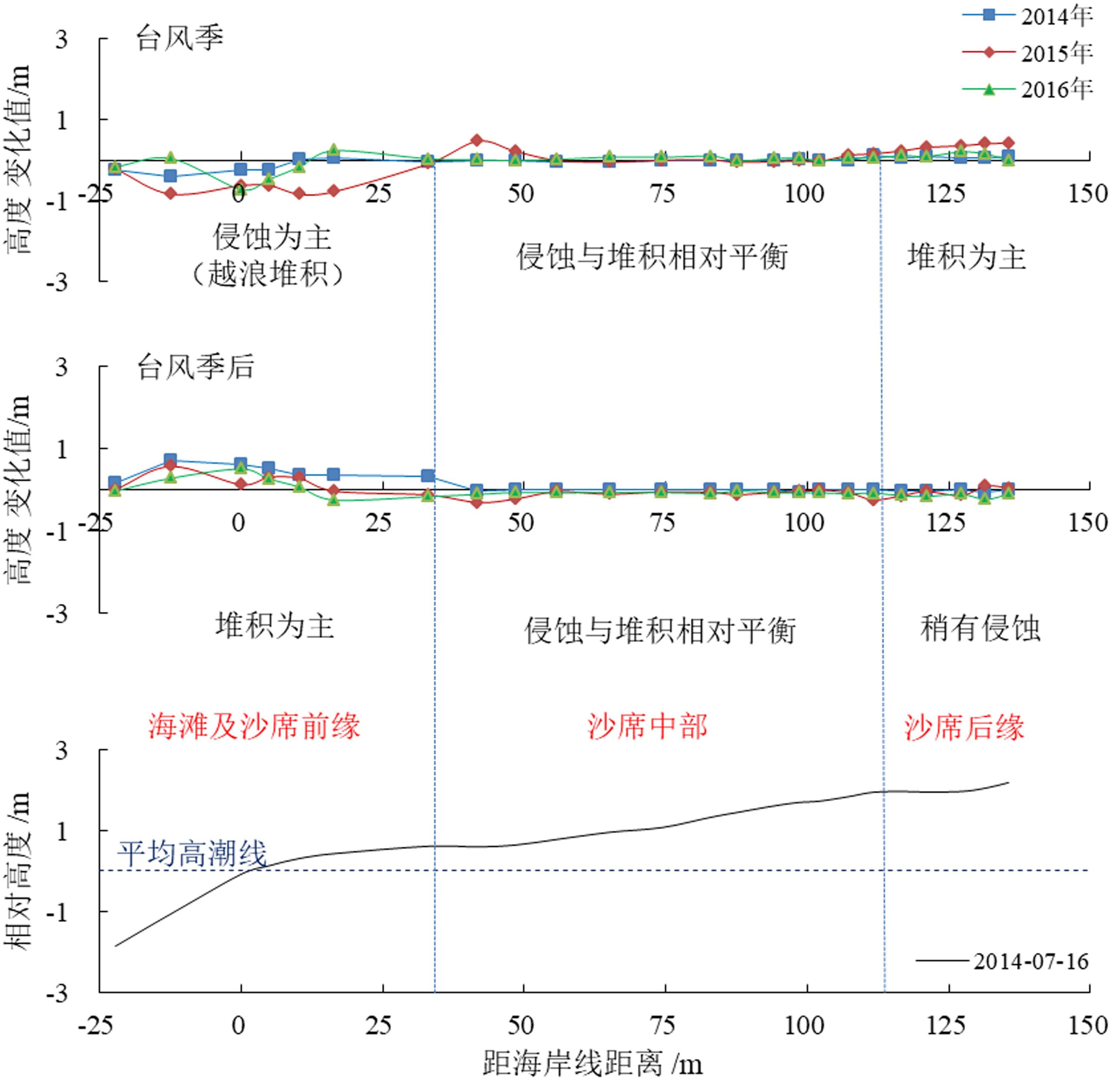
Typhoons, as essential influential factors for the formation and evolution of coastal dunes, are one of the most important aspects of surf zone-beach-dune interaction research. Pingtan Island is located on the eastern coast of Fujian Province, China, and preserves a typical type of coastal dunes on China's coastline. These dunes are well-known for their typical shape, volume, and limited human disturbance. Pingtan Island suffers frequent, unavoidable damage from typhoons, and was therefore selected as the study site for this research. Field investigations were conducted on the island before and after typhoon events, by using high-precision RTK GPS technology and surveying methods. The field site was visited 16 times between 2014 and 2017. We analyzed the morphological responses of coastal sand sheets to typhoons, and the related morphological changes. Finally, we summarized the morphological response patterns of coastal sand sheets to typhoons. This study is of great importance for comprehensively understanding the morphological evolution of coastal dunes, which is fundamental for effective coastal planning and management. The following results were obtained: (1) The typhoon imposed significant morphological changes on coastal sand sheets, which can be summarized as a decrease in the height of the beach and frontal coastal sand sheets (maximum erosional depth of 0.92 m), minor variations in the height of coastal sand sheets at middle sites (≤ 0.15 m), and a slight increase in the height of coastal sand sheets at the trailing edge (maximum accumulation thickness of 0.75 m). (2) After the typhoon season, the morphological changes in coastal sand sheets are more consistent, and they mainly manifest as a decrease in volume and a slight increase in the height of the beach and frontal coastal sand sheets (maximum accumulation thickness of 0.78 m). There was a very slight decrease in the height of the middle coastal sand sheets (≤ 0.10 m), and a slight decrease in height at trailing edge of the coastal sand sheets (maximum erosion depth of 0.47 m). (3) Coastline direction is an important factor that affects the response of regional coastal dunes to typhoons. At sites that lack sand resources and experience dominantly offshore wind, typhoons play a prominent role in frontal coastal sand sheet erosion, and can result in a receding coastline (up to 4.0-5.0 m).
Quanzhou Bay, the main port on the southeast coast of China, is the origin of the Maritime Silk Road. The landform is a semi-closed shelf bay. Two rivers, the Jinjiang and Luoyang, carry sediments to the bay and are connected to the Taiwan Strait. Sediment is also introduced to the bay from the open sea. Human activities have a strong influence on the bay, as does the occasional typhoon. Quanzhou Bay is characterized as a complex hydrodynamic environment with multi-source deposits. Grain size is an important indicator of the sedimentological characteristics of loose sediments, and it can reflect mixed sedimentary dynamics, sedimentary environment, and provenance. The End-Member Analysis method has the advantage of separating the mixed sedimentary dynamic components and has been widely used in sedimentology research. Many researchers have studied the sedimentological characteristics of Quanzhou Bay. However, further work on the identification of the dynamic components using End-Member Analysis methods is necessary to supplement previous work. In view of this, the present study adopts the particle size End-Member Analysis method, combined with sediment grain size parameters, water depth, and hydrodynamic forces, to analyze the sedimentation dynamics of 65 surface sediment samples collected in Quanzhou Bay of Fujian Province. Based on this analysis, we concluded that: (1) Owing to the continuous progress of sedimentary dynamics, separation, and sedimentation, provenance cannot be determined from grain size analyses, and only sedimentary kinetic characteristics can be defined; (2) Quanzhou Bay sediments are superimposed with at least four different dynamic end-member components. The distribution of the fine-grained End-Member components represented by EM 1 on the Quanzhou Bay area plane is generally corresponds to the weaker tidal hydrodynamics area. Therefore, we infer that this may represent a stagnant sedimentary environment with weak hydrodynamics. The EM 2 components, are somewhat high in the southern part of the bay mouth, and are relatively stable and with uniform distribution elsewhere in the bay. Considering the effect of tidal currents and the attenuation of tidal action in some areas, EM 2 components may represent the sedimentary dynamic environment of reworking under the action of typhoon storms. EM 3 and EM 1 components show an anti-correlation trend, which often occurs in areas with strong hydrodynamic forces. Therefore, EM 3 may be associated with a strong sedimentary dynamic environment under the action of tidal currents. The EM 4 component is generally higher in the northern part of the bay and in the estuary, but lower around the islands. This spatial distribution is likely to be caused by comprehensive human activities. There are many artificial sand-piling areas near Xiutu, and many cross-sea projects in the sea area north of Shihu, such as the wharf on the north bank east of Xiutu and the Cross-sea Bridge of Quanzhou Bay. The area affected by these projects coincides with high values of EM 4. The research in this paper is of progressive significance for a quantitative understanding of the complex sedimentary dynamics of Quanzhou Bay. Concurrently, by analyzing the dynamics and processes of sediment accumulation in the bay, a reference can be provided for channel dredging, utilization, and management for coastal zone development.
Droughts are the most common natural disasters with the most significant impact on human society. They are caused by water deficiency over extended periods. The Dongting Lake Basin is alternately controlled by winter, southwest, and southeast monsoons throughout a year, with meteorological droughts occurring each season. Additionally, the controlling factors for these droughts are distinct. The precipitation amount directly illustrates droughts and floods, affected by atmospheric circulation and water vapor conditions. Anomalies in atmospheric circulation are closely related to the evolution of Sea Surface Temperature (SST), which changes over long durations and is of significant importance for drought and flood forecasting over the basin. At present, studies that determine the linkage between SST and droughts/floods over the Dongting Lake Basin primarily show the statistical relationship between them; however, atmospheric circulation is the direct influencing factor of floods/droughts over the basin. Therefore, determining the relationship between meteorological elements and SST is conducive to revealing the mechanism of their statistical relationship. There are few studies on this research field in the Dongting Lake Basin. To determine the mechanism of the linkage between sea surface temperature and droughts/floods over Dongting Lake Basin and improve the understanding of forecast-improved factors for droughts/floods, this study analyzed the interannual evolution of droughts and floods in spring, summer, and autumn within the Dongting Lake Basin from 1960 to 2016 based on monthly precipitation data and NCEP/NCAR reanalysis data, investigated the distribution of global SST in typical drought/flood years, and studied the responses of meteorological factors (including precipitable water, sea level pressure, and wind fields at 850 hPa) to El Ni?o and Southern Oscillation (ENSO) and SST over key sea areas, using downscaling technologies and tendency analysis. Results show that in spring, the basin experienced interannual dry and wet alternations and an insignificant drying trend. In summer, droughts were slightly more severe than floods before 1990, and it was the wettest period from 1990 to the beginning of the 21st century. In autumn, the regional flood index (H) and regional drought index (G) remained almost stable, and typical drought and flood years appeared alternately. In spring, ENSO events in the preceding winter exerted a significant impact on droughts/floods in the basin. In addition, the SST over the southwest maritime continent (S1), the Masklin Islands (S2), and the Aleutian Islands (S3) all showed significant correlations with spring precipitation in the basin. These correlations last from the preceding winter to spring. The correlation between the SST at S3 and ENSO was weak. In summer, there was an insignificant statistical correlation between ENSO in the preceding winter and summer precipitation over the basin. The SST over the eastern Australian sea (S4) and the Bay of Bengal (S5) correlated with the summer precipitation in the basin from the preceding winter to summer; the SST signal over S5 was partially covered by the ENSO signal in the preceding winter. In autumn, the global SST had an approximately inverse phase compared to the typical drought and flood years of the basin. The SST anomaly in typical drought (flood) years of the basin was in the negative (positive) phase of the Indian Ocean Dipole (IOD) and La Ni?a (El Ni?o) pattern from the preceding summer to autumn; the two kinds of SST signals (IOD and ENSO) could independently affect droughts/floods in the basin. El Ni?o events in the preceding winter generated high pressures in the South China Sea and the east of the Philippines region in spring and summer, conducive to the transport of moisture from the South China Sea to the basin, resulting in greater precipitation in the basin. The high SST over the Nino3.4 region in the preceding summer also exerted a similar impact in the following autumn. When the SST at S3 was high in spring, the East Asian trough tended to be strong and westerly. In summer, a higher SST at S4 was likely to coincide with a weak East Asian summer monsoon. The mature phase of IOD in autumn was the dominant factor of droughts/floods over the basin.
Soil transfer and loss on the surface of terrain with karst topography due to fissures or caves in carbonate rocks, together with rainwater infiltration is a universal phenomenon. The degree of soil loss increases with increases in combined geological conformation movement, physical and chemical weathering, and corrosion. The combined action of underground soil leakage and surface erosion can lead to changes in the karst ecosystem and degeneration of soil and vegetation. Establishment of a grading standard for underground soil leakage is essential for assessing and analyzing degradation of karst ecosystems. For this purpose, a field study was conducted in Karst Mountain located in Liannan County, covering eight surfaces fractured by mining and road building, over 40 quadrats in Karst Hill, and the needle area of Yanbei town, Jiulong town, and Yingde city, north of Guangdong province. Based on field survey, we had got basic data, including data on 56 fissures, 40 doline funnels, and some karst caves in fractured surfaces, in addition,together with research results and survey data collected over 10 years in the Karst Mountains, hill, and needle Karst landscape, a grading standard for underground soil leakage, and a reference index for landscape characteristics of Karst mountain surfaces were set and discussed. (1) Three primary indices (fissure, karst cave, and doline funnel) and nine secondary indicators (connecting fissures between Karst caves, area ratio of fissures to fracture surfaces, fissure density, type of Karst cave, quantity of Karst caves, Karst cave location, doline funnel depth to width ratio, doline funnel shape, and fissure development surrounding a doline funnel) were selected. Underground leakage was stratified into four levels: no soil leakage, light soil leakage, moderate soil leakage, and serious soil leakage. The pathway of soil leakage, stage, relevance among all indicators, survey data from all fracture surfaces, and easily obtained index data were fully considered before selecting indices and standard data. Indicators were quantized to the extent possible, but were also combined with some qualitative indices to ensure practical grading of underground leakage. (2) Key features of karst landscape and data, including rock type, geomorphic features, landform, extent of uncovered rock, vegetation form, vegetation structure, vegetation coverage, and soil depth were selected to construct a reference index for determining landscape characteristics of the Karst mountain surface as an auxiliary index to the grading standard for underground leakage. A combination of these two sets of evaluation criteria will contribute to the development of an intact karst ecosystem evaluation method that is fully integrated with the assessment systems for rocky desertification. (3) This new evaluation criterion system for underground soil leakage will contribute to the overall assessment of karst ecosystems, especially for assessments of water and soil loss in road building, mining, and ecological environment construction, and can help us to draft a scientifically sound environmental governance policy for karst ecosystem resource utilization. These results will support further studies on karst ecosystems and more comprehensive evaluation of degraded karst environments.
An urban waterfront is an important place for urban residents to interweave their public life, social interaction, and nature. Based on the interpenetration theory of environmental behavior, taking the Pearl River Front Channel as an example, constructing a "people-environment" vitality interaction model from the vitality creation perspective, and using multi-source data and entropy method, Moran's Index, and Local Moran's Index, we quantitatively studied the vitality coordination degree of the waterfront. The temporal and spatial characteristics of people's vitality, the spatial pattern of environmental vitality, and vitality coordination are summarized. We discussed the vitality coordination mechanism of the waterfront and proposed optimization strategies for improving the vitality coordination of urban waterfronts. The results show that 1) people's vitality at the waterfront has spatial differentiation characteristics and significant spatial positive autocorrelation. In time, the hotspots show the spatial characteristics of expansion and convergence, while the cold spots show a scattered-concentrated spatial pattern. 2) The environment vitality at the waterfront has significant spatial differentiation characteristics, showing a spatial pattern of high west and low east. 3) The vitality coordination degree at the waterfront presents three vitality coordination states: high, medium, and low. The hysteresis system of the coupled coordination state is mainly the environmental vitality subsystem. 4) Mixed and diverse urban functions, continuous rhythmic city, and the landscape and the living road integrated with the waterfront are the keys to high vitality and coordination. This research proposes the following optimization strategies: 1) Make full use of water landscape resources (including the fine water bodies inside the waterfront, such as rivers and ponds), focus on the continuity of the landscape, and optimize the waterfront recreation experience. 2) Organize activities to create stories and memories at the waterfront by bridging the vitality of the crowd and the environment, forming a positive interaction, and coordinating the vitality at the waterfront. 3) Mediate social conflicts in the waterfront transformation process of the low coordination degree of waterfront, adopt an inclusive planning attitude, and encourage property owners whose current land-use type is farmland to plant both economically and ornamentally. For developing such areas where the current status is non-construction or ecological, intervention measures should be carefully selected to protect and enhance ecological values.
Based on the classical research paradigm of "spatial cognition-spatial preference-spatial behavior" in behavioral geography, a group of postgraduate students from University of Chinese Academy of Sciences was selected as a survey object. These postgraduates had similar social attributes, life experiences, subject background, and were not very familiar with the city. In addition, they lived in the school dormitory of UCAS, which is in the rural outskirts of Beijing. This survey used a combined method of hand-painted image maps and questionnaires, which was administered three times a year. The tracking investigation was conducted to observe the processes and characteristics of urban spatial cognition, spatial preference, and spatial behavior of the interviewed group during their stay in Beijing, and to analyze the interaction and influence mechanism of this process. The study finds that there is a certain coupling among urban spatial cognition, spatial preference, and spatial behavior, showing obvious differences. The three do not reflect a one-way causality, but have a mutually influential relationship. The group attributes of cognitive subjects (such as social relationship and cultural cognition), individual differences (such as experience and emotion), and the temporal and spatial constraints (such as contact time, spatial distance, and contact frequency with the object), affect the subjects' level and development process of urban spatial cognition. In addition, in the survey of these postgraduate students, some phenomena worthy of greater attention have been identified: First, the overall cognitive level of the students is not very high, and has not significantly improved within one year. We know this because less than half of these students draw "developmental" cognitive maps in the three rounds of surveys. Second, due to the special social and cultural background of the interviewed group, the preference for cultural places is high, but the proportion of real action converted from preference is lower. Lastly, the hotspots of behavior are concentrated in the northern part of the city. The distribution of spatial agglomerations is presented, with commercial centers and transportation hubs as the core; however, the the area south of Chang'an Avenue is less involved. Accordingly, we conclude that distance limits the space perception and travel intention of postgraduates of UCAS in Beijing. It also reduces the opportunities for students to make full use of Beijing's rich public resources, such as science, education, cultural, and art venues, and to enhance their experience and ability. They even create a bad impression of the city. As an exploratory study, this paper strives to analyze the interaction process among spatial cognition, spatial preference, and spatial behavior and its influencing factors through the survey of a proper social group. In the end, a generalized feeding association model of urban spatial cognition-preference-behavior is condensed.
In the context of urbanization, residents' local identities have become an important topic in the study of cultural and urban geography. Changing village committees to neighborhood or community committees (i.e., "village conversion") is an important way of urbanization, bringing many changes to the lifestyle of local residents; in particular, the mixed residence of immigrants and local residents has had an important impact on local residents' local identity. These two types of residents constantly interact and integrate to reform the local identity and become the key to the sustainable development of rural society. The impact of urbanization on urban development has expanded from large to small and medium-sized cities. However, academic circles pay less attention to differences in the local identity of residents in small and medium-sized cities. This article takes the village Y community in Lingbao City, a small and medium-sized city, as an example. The measurement of local identity mainly draws on the representative and mature relevant measurement scales, which are designed based on three aspects: local functional identity (interaction, participation, and satisfaction), local emotional identity, and intention to stay. The interview refers to the relevant influencing factors of local identity, mainly concentrated in aspects such as system, housing, individuals, local natural environment, and social culture. We designed an interview outline and specific questions based on the local identity scale. The research data were obtained through questionnaire surveys and semi-structured qualitative interviews. We used statistical test, factor analysis, qualitative research, a combination of qualitative and quantitative methods. We also conducted in-depth discussion on the changes in rural communities in the process of urbanization-after the "village conversion,"the group differences, and the influencing factors of local identity between local residents and immigrants in the process of population space and identity transformation. The research findings include: 1) The local identity level of local residents is higher than that of immigrant residents. The differences are mainly reflected in functional community participation, emotional community significance, and decision-making attention; 2) Local residents pay more attention to community participation. Although immigrant residents are concerned about the living environment of the community, their participation in the community is obviously lacking. The main reason for the difference is the continuity and imperfection of village rules and regulations in the process of community construction; the emotional identity of local residents and immigrant residents are significantly different. The former forms a self-constructed connection type emotional identification, and unites self and community into an inseparable whole, while the latter generates the other's gaze-dependent emotional identity, attaching the self-emotional identity to the evaluation of the community by others. The intention to leave and stay shows household registration-age heterogeneity, local residents' willingness to stay is clearer than that of immigrant residents, young residents are more willing to move out of the community, preferring to experience the environment and life outside the community. The intention to stay was based on the results of functional identity and emotional identity. 3) The difference in local identity is in the process of human-land interaction, community management system, local natural, cultural environment, and the result of differences in resident status. This study further enriches the research on the connotation of local identity while simultaneously promoting the social integration of residents in small and medium-sized cities. It promotes local community identity and provides a scientific basis for promoting the healthy development of cities. It helps to improve the identity of different groups in the changes of the community, promote the establishment of a new "city" identity of local residents, and enhance the integration of immigrant residents, both of which are important propositions for future urban and rural governance.
In recent years, with globalization, adjustment of the national welfare system, and social and cultural changes, studies on education has been receiving increased attention from disciplines such as education, geography and sociology, and different perspectives of society, showing obvious interdisciplinary characteristics. These studies have demonstrated a "new" look of education characteristics. Differentiation in the field of basic education is an important social and academic concern at home and abroad. This research focuses on learning in school, from the perspective of the interaction between resource supply and consumers, and provides details on education activities, their influencing factors and social spatial responses. In addition, non-traditional issues, such as supplementary tutoring and learning at home after school, have also attracted researchers' attention. However, a basic framework covering different fields and interpreting multiple differentiation has not yet been created. One reason is the different and dynamic topography, which leads to different factors and differentiation, requiring various frameworks. The complex integration of education resources and learning results for different social groups needs different framework, based on the researchers' perspectives. Moreover, the evolution of basic education's definition and its contents usually reduces the applicability of existing frameworks. Using the current situation of basic education and aimed at multiple differentiation, this paper proposes a research framework based on theories of socio-spatial dialectics, space-behavior interaction theory, and time geography. The framework is centered on students and their family—the consumer of education in different forms, emphasizing the interaction between students, space, and time. The main contents of the framework include learning at school, learning at home, and learning in tutoring agencies. The first focus of learning at school is the general differentiation pattern, including supply of education resources and its spatial distribution; students, family and their spatial representation; and finally, the classification of the differentiation types and its spatial depiction. The second focus is the interaction between school and community, including spatial structure of school districts and their evolution, schools' influences on communities (e.g., residents' formation and housing price), and community's influences on school (e.g., students' formation, school education, and governance). The third focus is education consumer's migration and commuting patterns, including social and economic features of moving people and the related projections, the commuting route, distance, mode, and related projections. For learning at home, the first focus is the mode, time, and contents relating to the type of self-learning: learning under tutoring or learning online, the consumption of time and money, the companion, and related projections. The second focus is the learning conditions and situations, concerning hardware facilities, environment conditions, companion, cost, and related projections. The third focus is the learning effects and related evaluation, concerning influences on academic performance, health, and family projections as well as the attitude toward learning. For learning in tutoring agencies, the first focus is the content and its space-time features, including social and economic features of the consumers, learning activities' spatial characteristics, time and money cost, and related projections. The second focus is the supporting conditions, especially travel and companion. The third focus is the effects and evaluation, including both daily and long-term influences on students and their family members, and consumers' attitude to and evaluation of the learning. The framework can work as the base for dialogue between disciplines as well as to promote the description and explanation of basic education's complex differentiation.
With the advancement of urbanization, reasonable allocation of public service resources is crucial for the sustainable development of cities and other regions. Education is the cornerstone of national revitalization and social progress; thus, the spatial distribution of educational resources should be in line with the overall trend of population distribution. This study attempts to evaluate the status of basic educational resource allocation on a finer scale based on population spatialization and POI (Point of Interest) data. We studied Changsha City in Hunan Province, where the 2018 census data were distributed into 100-m grids using POI, nighttime light, land use, road network, DEM (Digital Elevation Model), and other data as control variables based on the Random Forest model. We analyzed the spatial accessibility of basic education resources using cost weighted raster analysis and calculated the matching degree between the supply and demand of the resources using the improved potential model. The findings indicate that: 1) At the village (community) scale, the linear correlation coefficient (R2) of the population density between the result of population spatialization and the census data reached 0.73, which is better than WorldPop (World Population Dataset). Overall, the population distribution was displayed as a spatial distribution pattern of "one main-two sub-multi points", which could reflect the spatial characteristics of the population distribution in detail. 2) The spatial accessibility of the basic educational resources in Changsha was generally good: 97.72%, 96.20%, and 89.46% of the residents can reach the nearest primary schools, middle schools, and high schools, respectively, within 30 minutes. The difference in accessibility between the urban and rural areas was significant: the accessibility of the basic educational resources in facilities-intensive and traffic-developed areas was good and the villages (communities) with bad accessibility to basic education resources were concentrated in large counties with a large population of woodland and mountainous areas, especially in the surrounding mountainous areas of Liuyang County. 3) Generally, the basic educational resources in the urban areas of Changsha City and Liuyang and Ningxiang counties were in a balanced state of supply and demand; however, there were some areas where improvements were required. The matching degree between the supply and demand of basic education resources in towns was slightly higher, whereas in rural areas, it was mostly in a high-value state within the service radius and the intensity gradually decreased with facilities as the center. Therefore, it is necessary to strengthen the allocation of school buses and the ability of schools to receive boarding students to expand the scope of student sources. Previous studies mostly used large-scale census data, which ignored the spatial differences within each administrative unit. While some studies used small-scale census data such as those on residential quarters and buildings, however, these data are often difficult to obtain. This study provides research ideas for the precise assessment of the status of urban public service resource allocation and support for the diagnosis and improvement of the shortcomings of the basic educational resource allocation in Changsha City.
Based on landscape characteristics, regional development level, location conditions, public awareness, and management level, and others, we categorized thousands of karst landscape areas in China into four subtypes. These types include the following: famous attractions of karst tourism, classical destinations of karst tourism, new destinations of karst tourism, and new development areas of karst tourism. Then, using time as our theme, we researched the development modes of the tourism of karst landscapes in China over the past 70 years. To do so, we used inductive and analogical analysis. Our study found three main results. First, the main tourism development modes that have been introduced and that have acquired different implementation effects since 1950 are divided into nine types and thirty-eight species. Each have different respective requirements, thereby matching with different characteristics of various karst landscapes. Second, both different and the same types of karst landscape resource communities or areas often have multifarious tourism development modes. Multifarious tourism development modes have immense differences regarding the degree of importance, exploitation benefit, development tendency, among others. Conversely, the same tourism development mode may have different implementation effects, exploitation benefits, and development tendencies in the development of various karst landscape resource communities or areas. Third, we summarized two main types of development models (i.e., the characteristic and benefit-driven themeless-separated development and the characteristic and science-driven themed-converged development) and considered them to be the result of the karst tourism in special phases of development. The characteristic and benefit-driven themeless-separated development has played an important role in the development and prosperity of karst tourism. The characteristic and science-driven themed-converged development is a new development model comprising the resource community, scientific research, development, protection, management, and feedback, and would be the main trend of karst tourism development under the new situations. Finally, we explored the basic flow of the themed-converged development by using the system dynamics method. For this system dynamics method, resource community and its characteristics are its intrinsic motivation, scientific research is its outside motivation, protection, management, research(the anaphase),feedback, and so on are its operation systems which are derived from the motivation with theme as the soul.
High-speed rail (HSR) has significantly improved the accessibility of tourist destinations, thereby promoting the increase and gathering of tourist flow. In addition to promoting the development of tourism, the HSR may exacerbate the gap in regional tourism development. Thus, the tourism economic growth effect and distribution effect of HSR opening coexist. Existing studies are controversial regarding the growth effect. Moreover, they have not considered the distribution effect. Accordingly, it is urgent to test whether the HSR can become a promotion engine for the development of regional tourism or aggravate the development gap. Using provincial panel data of 20 ethnic regions in China from 2000 to 2017, this study evaluated the applicability of the difference-in-differences (DID) method through parallel trend testing and used DID to evaluate the impact of the HSR on tourism development in ethnic regions. In addition, three factors need to be considered to ensure robust estimation results. First, a placebo test is performed. According to the counterfactual hypothesis, the opening year of the HSR is advanced by two years, and the DID is used to perform an estimation again. Second, robustness tests are conducted using semiparametric-DID to perform an estimation and DID to perform an estimation by replacing the explanatory and control variables, respectively. Finally, the endogeneity test is conducted using Two-stage least squares method. The major research conclusions are as follows: 1) Overall, HSR has promoted the development of tourism in ethnic regions, with an average increase of 16.52% in total domestic tourist arrivals and of 23.29% in total domestic tourism revenue. Thus, HSR has a growth effect on the tourism economy in ethnic areas. Furthermore, HSR does not affect the gap in total domestic tourist arrivals among ethnic regions or in total domestic tourism income among ethnic regions. Hence, HSR does not have a distribution effect on the tourism economy in ethnic regions. 2) From the perspective of robustness, after replacing the variables and estimation methods, the HSR has a significant positive impact on the total domestic tourist arrivals and domestic tourism revenue in ethnic regions. That is, while it still has the growth effect of the tourism economy, it does not have the distribution effect, indicating that the overall estimation result is relatively robust. 3) From the perspective of the impact mechanism, HSR has a significant positive impact on GDP growth and industrial structure adjustment in ethnic regions, but it has no significant impact on population at the end of the year, passenger turnover, and cargo weekly transshipment volume. That is, the HSR has diffusion and structural effects but does not have a siphon or aisle effect in ethnic areas. Thus, the tourism economic growth effect of HSR in the minority areas is mainly due to the diffusion effect of HSR. Tourist flows from central cities or regions continue to flow to relatively remote ethnic regions and, simultaneously, promote the adjustment of the industrial structure in ethnic regions. As there is no siphon or aisle effect, HSR does not aggravate the regional tourism development gap. 4) From a dynamic standpoint, the growth effect of the HSR on the tourism economy in ethnic regions still lags. As time passes since the opening of HSR, its economic effect gradually weakens. Even if the opening time of HSR is extended, the distribution effect of HSR on the tourism economy in ethnic areas is still not observed. In general, this study examines the tourism economy of HSR. It considers its growth and distribution effects. This provides a basis for accurately evaluating the economic effects of HSR and guiding the inclusive development of regional tourism.
It has become increasingly common for tourists to share their personal travel experiences on social media. This user-generated content with spatial references provides a rich database for tracing the evolution of the cognitive image of a tourism destination over a long period of time. This is helpful for local authorities to improve destination management and marketing by prompting image adjustment and tourism product optimization to satisfy tourists' expectations. In this study, data on online travels on Ctrip.com, one of the most popular tourism websites in China, were collected and analyzed to reveal the spatiotemporal evolution of the cognitive image of Chengdu from 2000 to 2019. Based on a specific tourism-related lexicon, keywords were identified and grouped in a list, following a framework comprising six dimensions: tourism attraction, tourism leisure and entertainment, public infrastructure, tourism infrastructure, tourism environment, and local atmosphere. The six dimensions were further divided into 18 sub-dimensions. Under this framework, the general trends and spatiotemporal evolution characteristics of Chengdu's cognitive image during this period were analyzed. Specifically, changes in the shares of identified keywords related to the six dimensions during the period explained the general trend characteristics, while changes in the standard deviational ellipse (SDE) of the distribution of identified keywords with spatial reference, together with changes in the shares of identified keywords related to the 18 sub-dimensions in detail, were adopted to vividly show the spatiotemporal evolution of Chengdu's cognitive image. Our findings revealed that Chengdu's cognitive image has experienced obvious spatiotemporal evolution across different sub-dimensions over the past 20 years. Generally, the cognitive image has became substantial during this period, with a continuous increase in the total share of identified keywords related to the cognitive image of online travels. In addition, the shares of keywords related to the six dimensions and 18 sub-dimensions varied across different stages. Particularly, the spatiotemporal evolution shows that (1) there is an evident shift from sightseeing tourism to experience tourism, as SDE shifts toward the southeastern urban area and the share of identified keywords highly related to experience consumption increases; (2) the city tends to be more "leisurely and carefree" in tourism, as SDE tends to be more concentrated in the urban area with a relatively high density of leisure attractions; and (3) the cognitive image responds to natural hazards promptly, as the size and directions of SDE vary accordingly, and the share of identified keywords related to public infrastructure, tourism infrastructure, and tourism environment reached a peak after the Wenchuan earthquake. Based on our findings, the mechanism forming Chengdu's cognitive image was further discussed from the perspectives of government, residents, and commercial organizations. Methodologically, this study proposes an approach based on text mining and analysis of online travel, typical spatial big data generated by tourists, to examine the cognitive image, which could be applied to other tourism destinations. Moreover, the mechanism framework based on the Chengdu case provides recommendations on tourism destination image management and marketing to improve responses to tourists' changing expectations regarding other tourism destinations.