The Beinecke Library of Yale University owns an ancient Chinese sea atlas, Zhongguo gu hang hai tu, which has attracted considerable scholarly interest over the last three decades. In 2018, Wing-Sheung Cheng published his research monograph focusing on this atlas. However, his identification of certain geographical features is problematic; in particular, the Wailuo (外罗), depicted several times in the pages of the Zhongguo gu hang hai tu, is identified as either Robert Island or Money Island in the Paracel Islands. Based on comparison with other sources, which invariably place the Wailuo near the coast of modern Vietnam (Cù Lao Ré), it is concluded that Cheng misread the cartographic representations of the atlas. In order to better elucidate the causes of this misreading, this paper introduces the epistemological concept of "tacit knowledge," coined by the philosopher Michael Polanyi (1891-1976), into the study on the history of cartography. Tacit knowledge as a notion has developed different meanings since Polanyi, and is construed as the opposite of explicit knowledge. Matthew H. Edney has championed the investigation of the mapping process rather than simply the mapping practice in the history of cartography. It is argued that the mapping process of ancient nautical charts involved tacit knowledge, which was not fully inscribed into or depicted on the charts. Acknowledging and revitalizing such tacit knowledge is of paramount importance to the study of the history of cartography. Because modern and scientific cartography has transcended and obfuscated the mapping process of ancient sea charts, tacit knowledge is sometimes ignored or misinterpreted, which eventually results in ancient maps and charts becoming seemingly unintelligible. Therefore, the underlying cause for Cheng's misreading of the Wailuo can be attributed to his over-reliance on the explicit knowledge drawn on the pages of the atlas, and ignorance of the rich tacit knowledge that was passed down through generations of Chinese seafarers, until it was overtaken by modern sea charts. This case study also echoes recent debates regarding the progress and setbacks in the history of cartographic studies in China. It shows that theoretical exploration is capable of facilitating the improvement and long-term viability of the history of cartography in the Chinese language world.

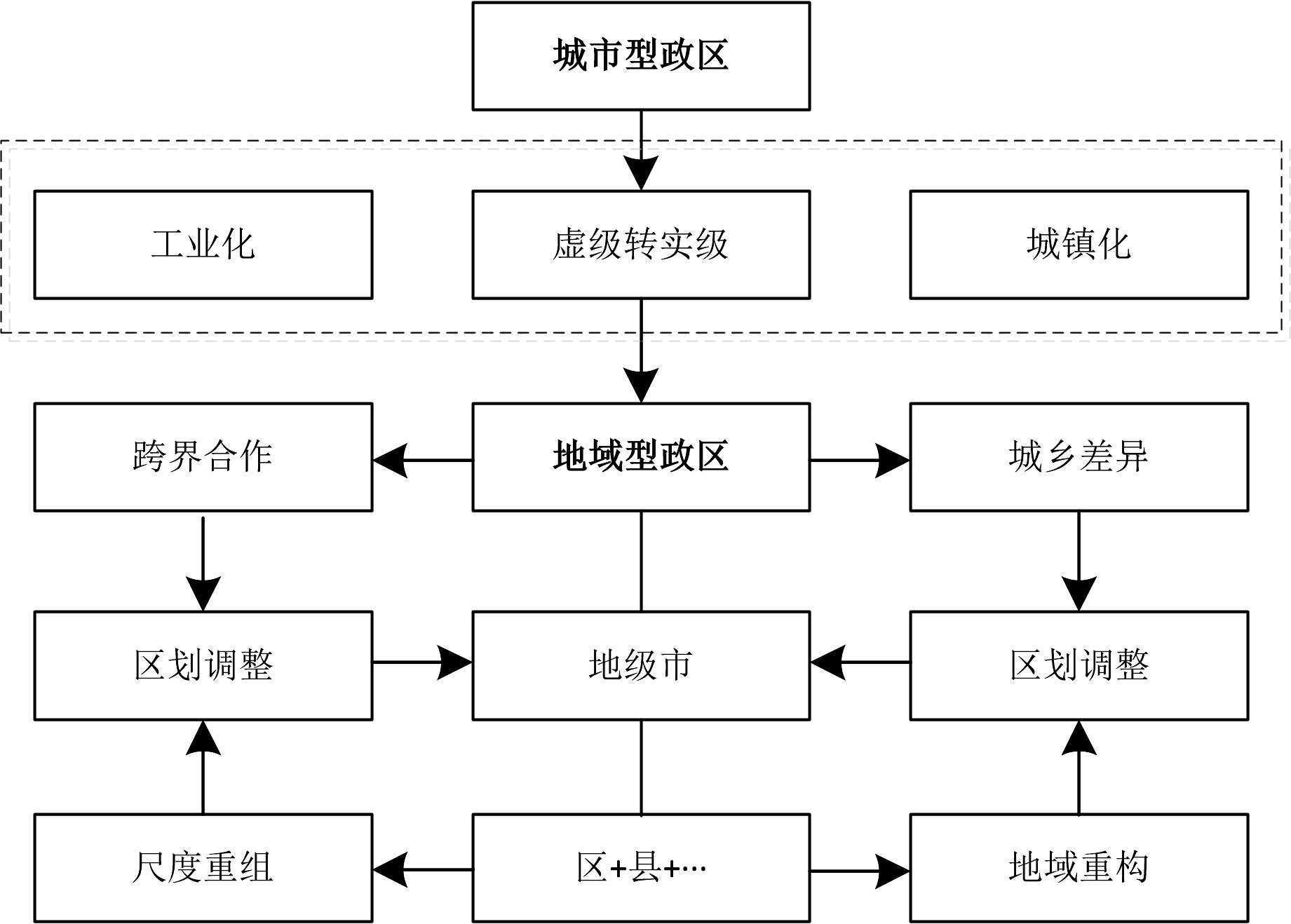
The establishment of prefecture-level cities is a major spatial achievement of the social structure transformation in the process of modernization in China. The optimization of the layout structure of such cities is an inherent requirement for deepening supply-side structural reform and is of great significance to the construction of a scientific and reasonable urbanization pattern. Using the district similarity coefficient and standard deviation ellipse model, this study discusses the spatial characteristics and existing problems of prefecture-level city setting. The results reveal the following: 1) In terms of spatial characteristics, since the reform and opening-up, the setting of prefecture-level cities in China has been greatly affected by policy factors, exhibiting a gradual trend of advancing from east to west and from coastal to inland. 2) After reform and opening-up, the addition of prefecture-level cities is an adjustment on the basis of the original regional system, including the establishment of a city, the merger of a city, promotion of a county or county-level city to a city, and so on. 3) With the development of economy and society, the "space" problem of the prefecture-level city setting has become increasingly prominent, which is closely related to the difference in the mode of city setting, resulting in the administrative centers above prefecture-level setting too close, "small horse and big cart" and other problems to varying degrees. 4) The spatial distribution of prefecture-level cities in China is generated in regional administrative districts against the background of industrialization and urbanization, developed in the strategic transformation of urban-rural differences and cross-border cooperation, and faced with the innovative challenge of regionalization adjustment in the process of regional restructuring and scale restructuring. 5) The "space" problem leads to the increase of the system cost of economic and social development to varying degrees. Therefore, the layout of productivity should be comprehensively considered in a wider scope, and the adjustment of prefecture-level administrative divisions can be carried out when necessary. The possible contribution of this study to the literature is reflected in the application of the similarity coefficient of administrative districts to reveal that "the prefecture-level city is highly similar to the original region." Moreover, the problems existing in the current setting are related to this, such as too close distance and call for great importance to the significance of the adjustment of administrative divisions of the prefecture-level city. The possible shortcomings are that the logic of such city administrative division adjustment needs to be further explored, and the analysis of the thinking path of this adjustment is insufficient. In the future, the research on relevant issues in prefecture-level cities should be strengthened. Additionally, it is necessary to change the thinking of the adjustment of the overall construction system and the internal adjustment of prefecture-level government districts, consider the layout of productive forces from a broader perspective, consider the level of administration, the scale of government districts and the spatial structure as a whole, and take comprehensive measures to meet the actual needs of national and local development.
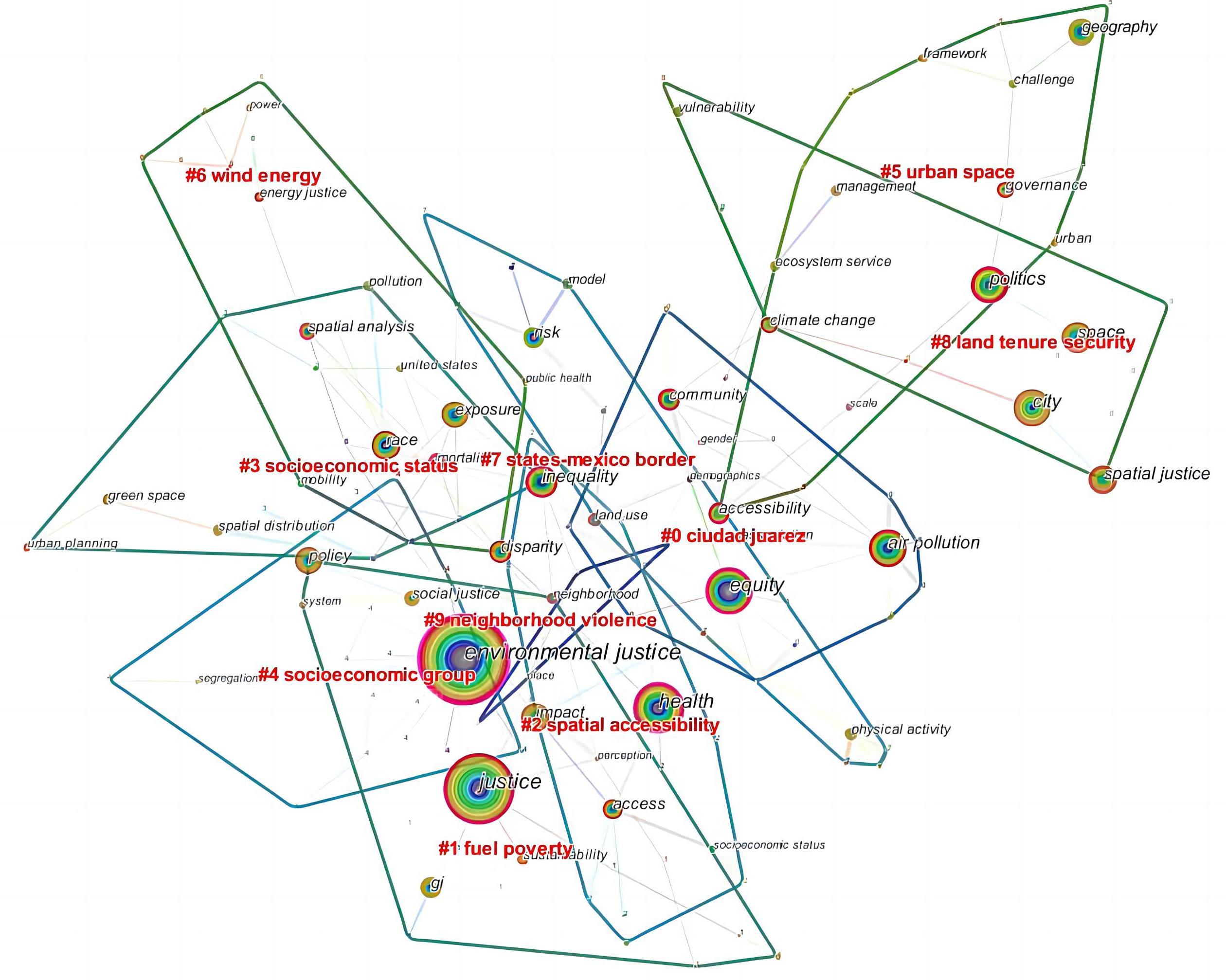
The issue of "spatial justice" has become a hot topic among urban research and planning scholars in China. An analysis of 1516 English-language documents in the Web of Science (WOS) from 2000-2021 was conducted through CiteSpace. Knowledge maps of keyword clustering, core author groups, and research institutions were mapped to reveal the hotspots and trends of foreign spatial justice research. The results reveal the following: (1) Foreign literature issuance exhibits a phased upward trend, divided into three stages of exploration (S1), stabilization (S2), and explosion (S3). The publication volume increased steadily in S1, contending and flourishing around the theme of space deprivation, exclusion and poverty. The publication volume has increased significantly in S2 compared with S1, the connotation of spatial justice is gradually clear and complete, environmental justice has received significant attention, and the influence of process and procedural justice is increasing. The spatial justice research has explosively grown in S3, focusing on the value effect and practical significance of spatial justice in the post-globalization era and stock development period. (2) A total of three hotspots emerged in foreign spatial justice research: The rise of research targeting youth and children, who have become one of the main actors and are motivated by awareness and environmental change to actively participate in the fight for justice on a global scale. Environmental justice research is booming with divergent and extended content, focusing on waste trade and climate change. The public and green spaces of the city have become research hotspots as the pursuit of spatial justice value turns to high quality and sustainability. (3) Trends in spatial justice research abroad include integration of environmental justice and urban space, as well as scale synthesis and thematic expansion driven by technological progress. In general, the maturation of foreign spatial justice research provides an important reference for the theoretical construction and practical application of spatial justice in China. How to connect with the international frontier, form research results with local characteristics, and effectively implement them in current spatial practice in the context of new urbanization is an urgent issue to be solved.
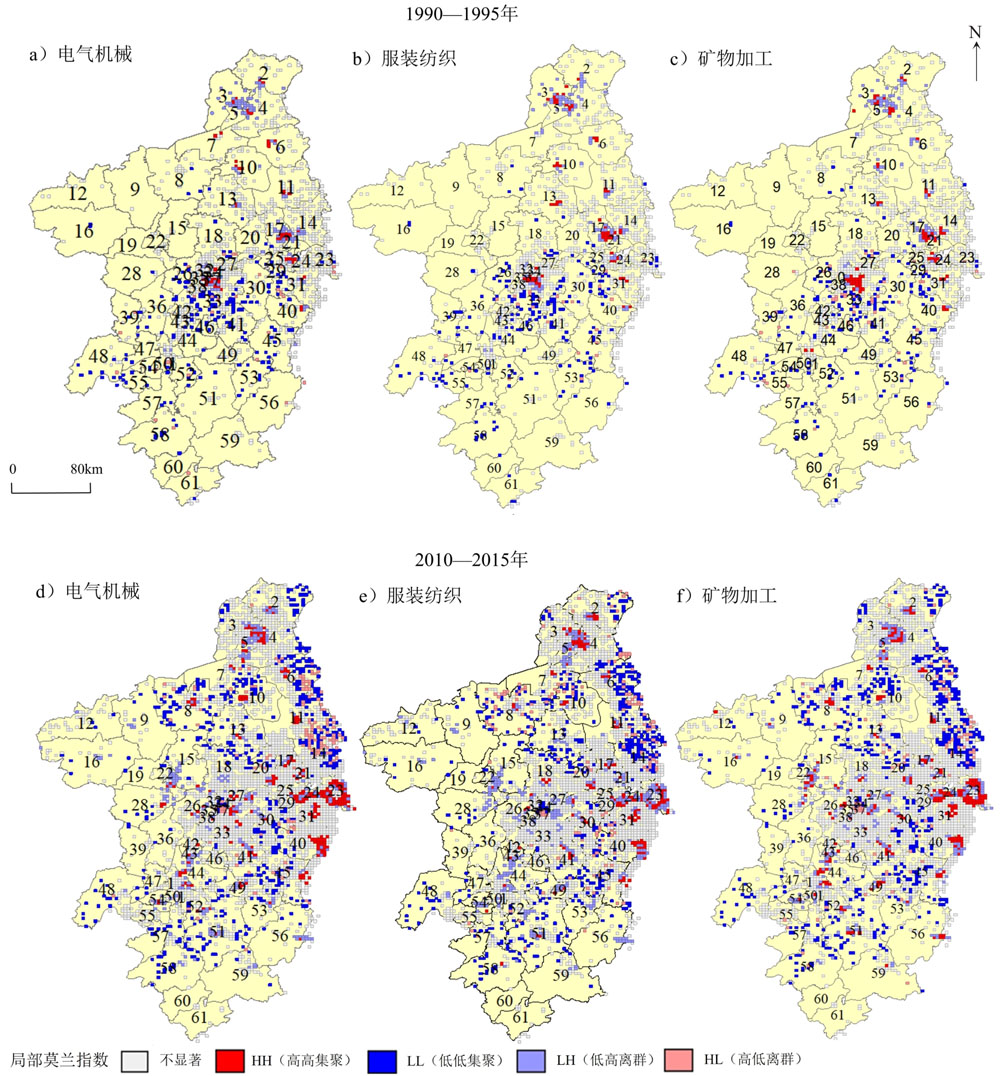
With the integrated development of the Yangtze River Delta as a national strategy, urban development in the Nanjing metropolitan area has entered a new stage. However, facing the large differences between the newly joined districts and counties are the key issues of ensuring the driving role of Nanjing as a central city and guiding future high-quality development of the metropolitan area by planning the industrial layout. In this study, enterprise big data and impervious surface data were used as the sources to employ fractal theory, GIS spatial analysis, and other techniques to study the historical evolution characteristics of the built-up areas in the Nanjing metropolitan area. The spatial pattern changes of their expansion intensity have gone through three periods: 1990-2000, 2000-2010, and 2010-2017. The following stages were observed:1) In the first stage, the expansion intensity varied widely across the area with the overall pattern being unclear to date. 2) In the second stage, a circular structure emerged gradually with high-value cores located in the main downtown area of Nanjing and the intensity of expansion decreasing from the core to periphery. 3) In the third stage, the number of cores within the circle gradually increased to include Chuzhou Langya District, Huaian Qingjiangpu District, and the border area between Zhenjiang and Changzhou. Based on these stages, the spatial correlation between industrial agglomeration and spatial evolution of built-up areas in the Nanjing metropolitan circle were further analyzed using quantitative indicators such as the Moran index and locational entropy. The following results were obtained. 1) A global positive correlation was observed between the agglomeration degree of manufacturing industries in the metropolitan circle and the spatial evolution intensity of built-up areas during 1990-2015; however, this global-level correlation has decreased in recent years owing to the slower development of manufacturing industries in some regions than the expansion of built-up areas. 2) The structural differences between the manufacturing industries in each region directly influenced the intensity and speed of built-up area expansion. Additionally, different types of manufacturing transfers caused differences in the speed and intensity of expansion of built-up areas in the hinterland of metropolitan circles, affected by the general trend of industrial division of labor in metropolitan circles. 3) The mineral processing industry showed the widest spread among all labor-intensive and low value-added industries. It also possessed the widest diffusion range and played a driving role in the development of built-up areas in each district and county in the long term, whereas for the remaining industries, the initially strong development of built-up areas weakened thereafter. Therefore, it could be argued that the Nanjing metropolitan circle is in a critical period of coordinated regional development, and the initiatives to transfer low-end manufacturing industries to other regions in the circle must be taken in Nanjing while continuously improving its own supremacy by means of collaborative development and innovation. Simultaneously, the sloppy land resource investments in other regions must be altered to improve efficiency.
Domestic research on the planning of the Tokyo metropolitan area of Japan mainly includes evaluation and comparative research. The former involves the perspectives of planning interpretation, experience summarization, and history evolution; the latter compares and analyzes the three major urban agglomerations in China against the Tokyo metropolitan area. On the whole, most evaluation studies focus on the metropolitan area planning itself, and rarely focus on that of each prefecture and county under the metropolitan area. The relationship between these lower-level and metropolitan area planning has received relatively little attention. Comparative studies mostly cover various fields such as economy, industry, environmental protection, and so on, but the discussion paradigm is generally based on "introduction to the current situation → inspiration and reference," with rare objective comparison made under a reasonable benchmark and appropriate framework. At the same time, comparative research on urban agglomeration planning itself is also uncommon. As important spatial representations of the economic development in China and Japan, with what important planning has the Tokyo Bay Area (TBA) and the Guangdong-Hong Kong-Macao Greater Bay Area (GBA) developed to date? How do these plans relate to each other? What are the characteristics and differences? What results did these similarities and differences ultimately lead to? Answering these questions is not only related to the construction effectiveness of the GBA itself, but also has certain significance for other urban agglomerations in China. In this context, we adopt "development" and "space" as the two perspectives to analyze the planning system of the two major bay areas from the aspects of planning property, background, target area, goal, regional positioning, and main measures. On this basis, the similarities and differences between the two are summarized in six aspects: historical background and relevant system, departmental and institutional system, vertical transmission mechanism, horizontal coordination mechanism, planning system characteristics and public participation. This study argues that the following: (1) The two bay areas have played leading roles in industrialization, urban system construction, and urban agglomeration planning system construction in each country, but there are differences in the historical backgrounds and relevant social systems. (2) Under the decentralization of powers, the setting and naming of departments and institutions of TBA are relatively flexible, and they participate in the preparation process of comprehensive planning in the form of "Council." Except for Hong Kong and Macao, the departmental settings of GBA are orderly, clear, and consistent in form. (3) In terms of vertical transmission system, the central-level planning of TBA is self-contained and continuous but that at the county-level is relatively free, and the upper-level planning is not absolutely mandatory; the relationship between the upper and lower levels of GBA-related planning is relatively clear but that at the regional-level has some flexibility in execution. (4) In the horizontal coordination system, the TBA has established two major joint meeting systems to coordinate regional governance and planning formulation, while planning has weakened the positioning to each city's functions. Furthermore, GBA has also established cooperation mechanisms with different levels of cooperation for various issues, and the characteristics of planning for the positioning of urban functions are still obvious. (5) In terms of planning nature, the developmental and spatial planning of TBA have been combined into comprehensive planning, and the spatial aspect has obvious characteristics of stock planning. GBA still formulates planning from three aspects of development, space, and urban and rural areas and is in the transition from incremental to stock planning. (6) In terms of public participation, TBA has broken through the traditional planning paradigm and has begun to involve micro-fields such as personal value, with a high degree of public participation. In recent years, GBA has continuously enriched the planning content and has also made progress in the construction of public participation mechanisms and awareness training, but there is still room for improvement.
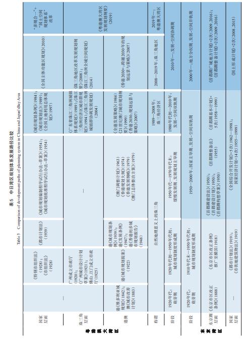
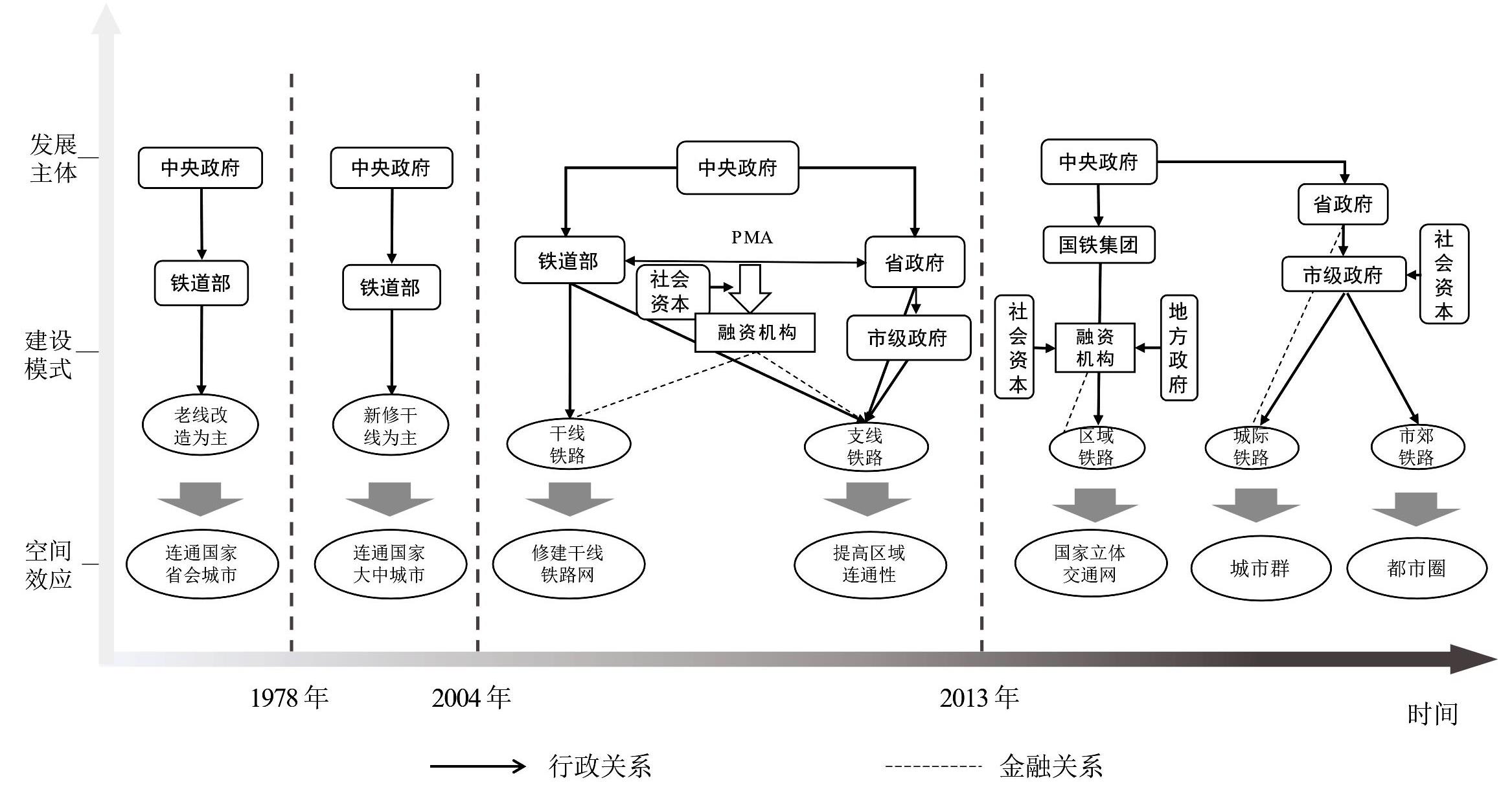
Based on a literature review and policy analysis, this study investigates the evolution of China's railway investment and financing, planning, and development in the context of its market-oriented reform. The relationship between railway and multi-level spatial development is divided into specific periods. The features of different stages are summarized from the perspective of railway financing structure, route arrangement, station location, and their spatial effects. This study contributes to our understanding of the changing multi-level governance of railway development in China in the long run and the rationale of the pattern of high-speed rail network development in the country. With the establishment of China's market-oriented economy and its integration into economic globalization, the central and local governments have different interests and objectives in railway development, which have affected railway investment and financing structure, route arrangement, and station location, and finally resulted in different spatial effects of railway development. Since the establishment of the People's Republic of China, the relationship could be divided into four periods: i) railway services adapted to national economic and spatial development (1949-1978), ii) railway services lagged behind national economic and spatial development (1978-2004), iii) railway construction followed national economic and spatial development (2004-2013), and iv) railway construction led national economic and spatial development (2013-present). The main body of railway development, construction mode, and spatial effects were significantly varied across different periods. In the planned economy period, railway planning construction adapted to national strategic policies and social and economic needs. As China's institution of the market economy was established and urbanization and industrialization developed rapidly, railway construction was hindered by funding constraints, resulting in a significant gap between railway services supply and the increasing national transportation demand. Consequently, railway construction has gradually fallen behind national economic and spatial development. However, there are differences in the national and local interests between the central and local governments in planning and developing railway networks, which have driven the evolution of railway construction toward a multi-level construction mode. This mode centers around the national backbone network, dominated by the central government, and aims to promote the construction of national development corridors and urban agglomerations. The planning for metropolitan areas has been facilitated via inter-city rail networks, led by provincial and municipal governments. In this process, conventional railways are gradually being replaced by high-speed railways (HSR), which have become the priority of railway development. Subsequently, development has shifted from the construction of conventional railways to meet regional transportation and population flow needs toward the planning and construction of HSR that lead multiscale spatial restructuring. In the context of rapid expansion of high-speed rail development, some spatial problems emerged, such as negative impacts of HSR development on small and middle-sized cities, low land use efficiency in station areas, and weak functional connections between station areas and central cities. Therefore, to promote the coordinated development of urban agglomerations and metropolitan areas, it is necessary to develop station areas based on local and regional conditions and enhance the interaction of high-speed rail effects at different scales.
Recently, dockless bikeshare (DBS), a new bikeshare program that does not feature fixed dock stations, has been developed rapidly in China and has also offered a decent solution to the first- and last-mile problem. In addition, the integration of DBS and metro strongly promotes the transit-oriented development, particularly in the metropolitan areas of China. To achieve the seamless connection between DBS and metro transit, the spatial variation of the effects of urban built environment, particularly in high-density metropolitan areas, should be explored to advance the targeted policy interventions in different urban spaces. Using data from one of the largest DBS operators in China (ofo), this study measured the integrated use of DBS and the metro quantitatively, and it employed geographically and semiparametric geographically weighted regression (GWR and SGWR, respectively) to examine the effects of the built environment on the integrated use, using Shenzhen as a case study. The findings show that (1) The SGWR model performs better than GWR and OLS in explaining the relationship between built environment and access integrated use, whereas SGWR is not applicable for the egress integrated use. (2) Three positive determinants of population density, major road length and inbound metro ridership, and three negative determinants of metro density, secondary school, and intersection density have been examined with spatial effects on the access integration. (3) For egress integration, official land use, park, bus stops, and outbound metro ridership have positive and spatial effects, while residential land use, number of secondary school, metro density and distance to CBD (Central Business District) exert negative spatial effects. The results indicate that the built environment elements usually affect the integrated use with spatial variation. Furthermore, the access and egress integration use of DBS metro largely depends on the characteristics of built environment of the origin and destination metro catchment, respectively. This work provides insight into how the DBS-metro integration, which is divided into access and egress patterns, is spatially affected by urban built environment in the Chinese metropolitan context. The results will also provide a reference for the local government to carry out the targeted policies and planning to encourage the connection between DBS and metro transit more successfully. For DBS operators, the results also contribute to allocating the bikes more efficiently, which is adapted to the dynamic demand-supply at different urban spaces.
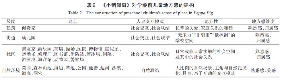
Research on sense of place in the field of geography is mostly focused on adults, with relatively little research on children's sense of place, ignoring changes in human perceptions, experiences, and attitudes toward the environment from childhood onward. In the field of psychology, child studies tend to focus on the temporal dimension of childhood growth and are relatively inadequate in the spatial dimension, lacking attention to interactions and actual experiences of children with place and space. This study focuses on the human-place relationship of children in daily life against the background of the new turn in cultural geography. Among children, animation, as the main medium through which they perceive the external world, contributes to their cognitive and emotional connections with families, communities, schools, and even cities, and plays an important role in fostering their sense of place. Therefore, based on the perspective of new cultural geography, this study takes Peppa Pig as an example and uses text analysis and other methods to analyze the mechanism through which animation builds children's sense of place by analyzing the scenes and plot elements of the animated series. This study finds that this mechanism contains the following four main dimensions: (1) Aesthetics and familiarity: This dimension includes small-scale and symbolic scene restoration of Peppa Pig; simple, caring, calm, and with the use of warm colors; and childish and awkward drawing styles that meet children's cognition, which can resonate with children and create a sense of familiarity. (2) Sense of belonging: In the social space that the protagonist is exposed to, the animation depicts an ideal family space, including the care of elders and the harmony of family relations; children thus form a sense of "home space" through Paige's "home." Through Paige's "home," children form a sense of belonging to "home." (3) Social bonding and social interaction: In this dimension, the "stress-free" "non-tame" and "low-control" school space implicitly influences children's cognitive and emotional connections to school; in addition, the richness and variety of social scenarios build bridges between children and the real social environment. (4) Nature bonding: The large proportion of nature scenes in the animation effectively compensates for the lack of nature experience of many urban children; the interaction mode between the protagonist and nature panpsychism, embodiment and parent-child interaction enriches their cognition and experience of the natural environment. Overall, through the interactive experience between the protagonist and the place, the animated series "Peppa Pig" shows preschool children the "non-controlled" locality of family space and the "non-regulated" locality of school space, constructing their sense of beauty, familiarity and a sense belonging to the place. In this sense, animation, as a "virtual buffer zone" that expands children's cognitive space, can stimulate their geographical imagination of the real world and is an important medium for developing their sense of place. The interpretation of this mechanism in this study helps to enrich the current research on children's geography and sense of place in China.
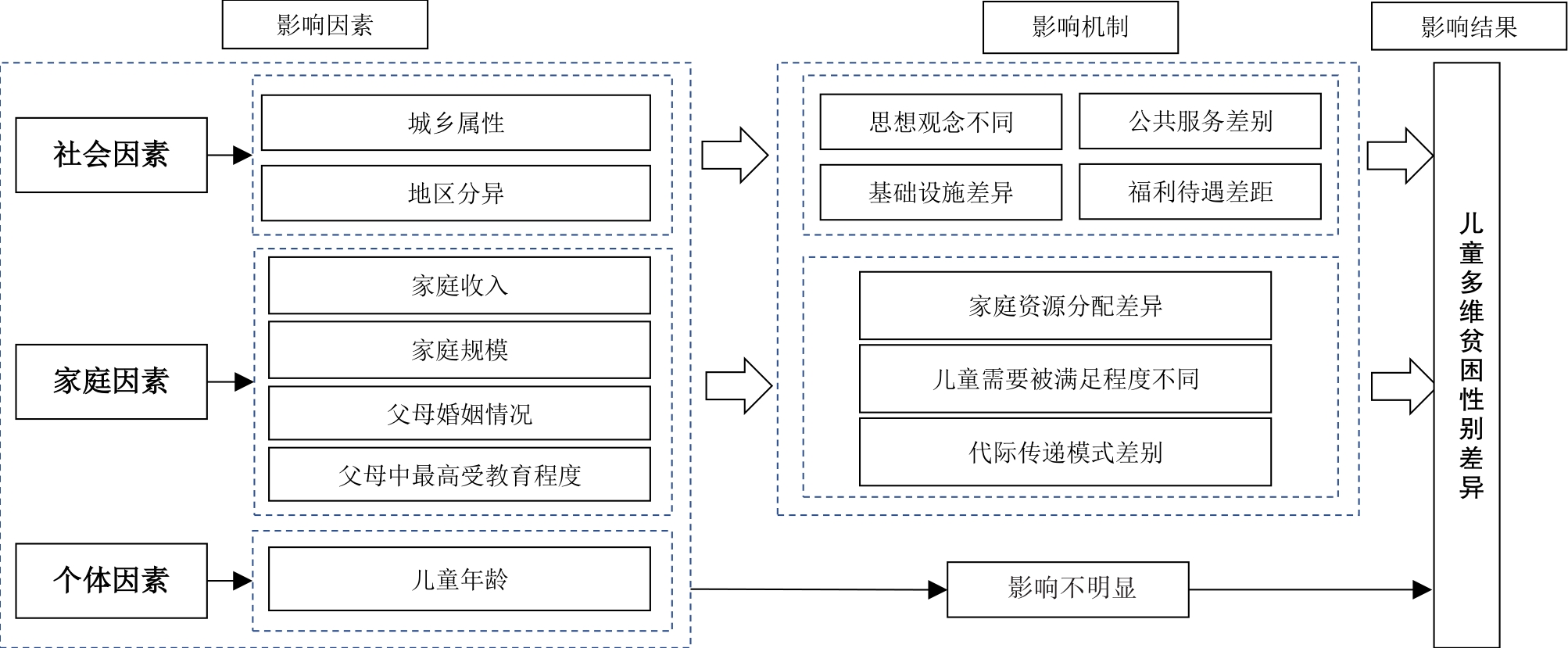
Children are the hope of the future, but they are also the most vulnerable to poverty. Gender differences in children have been a major concern in society, and research on gender differences in multidimensional child poverty and their causes has important theoretical value and practical significance for child poverty reduction. Based on spatio-temporal analysis, we selected five dimensions of nutrition, health, education, individual growth, living conditions and 16 corresponding evaluation indicators to construct an evaluation index system of multidimensional poverty among children in China. The multidimensional poverty index of Chinese boys and girls from 2010 to 2018 was measured using the Alkire-Foster (A-F)method. Additionally, the spatio-temporal variations of gender differences in multidimensional child poverty during the period was analyzed using spatial autocorrelation and other methods, and a binary logistic regression model was applied to explore the influencing factors of gender differences. The results reveal the following: 1) The multidimensional poverty index of Chinese children decreased year by year during the study period, and the gender gap tended to narrow, with the poverty level of boys being higher from 2010 to 2012, while that of girls exceeded that of boys after 2014. Moreover, the gender difference in child poverty is mainly reflected in nutrition and living conditions. In terms of the contribution rate of indicators, the gender difference in the contribution rate of weight indicators is the largest, followed by height, family companionship, and enrollment at an appropriate age. 2) The multidimensional poverty index of boys and girls reveals the spatial distribution characteristics of "East-Central-West" stepwise increase. Compared with boys, the spatial clustering effect of multidimensional poverty among girls is more obvious. In 2018, the regions with significant gender differences in multidimensional child poverty are mainly concentrated in the five provinces of Fujian, Hunan, Jilin, Shaanxi, and Hubei. Additionally, the overall situation of multidimensional poverty among girls is more serious. 3) Since 2010, the gender differences in multidimensional poverty among children in China's urban and rural areas have displayed a decreasing trend; the gender gap is generally higher among urban children than rural children. In 2018, the gender gap in poverty among urban children is very significant in the four provinces and cities of Fujian, Chongqing, Hunan, and Guizhou, while that among rural children is more serious in Heilongjiang and Shaanxi provinces. These six provinces exhibit more poverty among girls, indicating that this is a priority for future improvement. 4) Urban-rural attributes, parental marital status, household income, and the highest level of education among parents are important factors influencing the gender differences in multidimensional poverty among children. Among these, household income has a deeper impact on girls, while urban-rural attributes, parental marital status, and the highest level of education among parents have a more significant impact on boys.
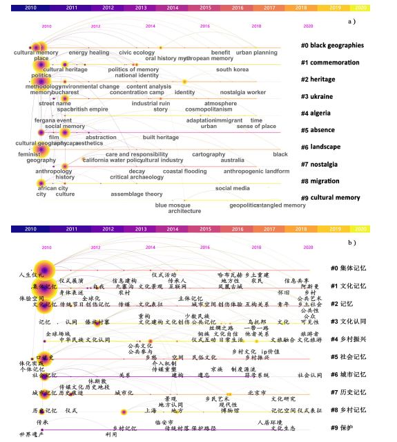
Cultural memory is a spiritual, inner, and middle world composed of self-consciousness, memory, and behavior that expresses the cultural phenomenon, local emotions, and identity generated by human practice in the present world space. Geography pays more attention to the human-land relationship and spatial perception in the formation of cultural memory and constructs a unique cultural memory space. This space is the agglomeration of figurative cultural relics in space, as well as the spiritual representation of non-figurative places, such as art, text, and folklore in space. By systematically analyzing the theory of cultural memory, this study summarizes the process of evolution and development context of cultural memory. Based on 1,527 key domestic and international studies on geography, this study analyzes the main content and progress of global cultural memory space research from the perspective of keyword co-occurrence clustering, theme path evolution, and research trend, with the assistance of CiteSpace—the bibliometrics and visualization tool. By reviewing the frontier hot spots of cultural memory space research at home and abroad, this study aims to construct a research paradigm of cultural memory from the perspective of geography, improve the research methods of cultural memory, and provide a reference for the local application and multidisciplinary integration of cultural memory theory. The analysis results focus the research topics of foreign cultural memory space primarily on: 1) the memory representation of the landscape of daily life; and 2) political and ritual studies in memory. Domestic research topics primarily include: 1) cultural and local studies in collective and social memory; 2) research on urban and rural memory carried by space; and 3) research on heritage memory reproduction, promoted by cultural tourism. The literature on cultural memory space at home and abroad has gradually increased in recent years, as has the attention paid to memorial landscape, heritage buildings, ritual celebrations, war trauma, and national memory; however, the research on cultural memory space has not formed a specific theoretical paradigm. Most of the literature only focuses on the integration of cultural memory and other fields, and relatively few studies address the connotation of cultural memory space, media conversion mechanisms, and spatial identification methods. The perspective of the content and trends in domestic and foreign research indicates that Western scholars pay more attention to the study of migration, rights, free will, women, power politics, and war trauma. The focus on space is mainly on cities, emotions, and rights. Domestic geographers focus on deconstructing regionalized and China-seized cultural memory and local identity from the intangible carrier of memory. Most studies are based on obvious policy orientations. War sites, red tourist sites, traditional villages, characteristic folk customs, and festival ceremonies have become important themes in the study of cultural memory space. In the future, geography research should depict the practical process of text, ritual, and language through non-representational means and re-introduce memory into human research in a materialized way. Simultaneously, the connotation of urban and rural cultural memory should be clearly defined, and heritage, immigration, and tourism should be adopted as the new themes of cultural memory space research through digital images.
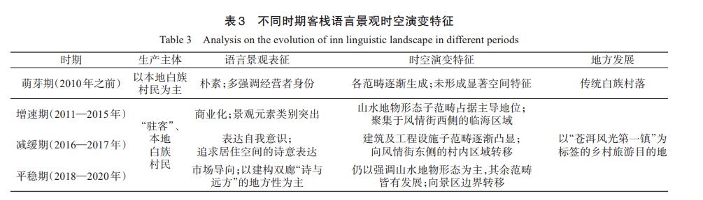
Linguistic landscapes, which refer to language and text displayed in public areas with a certain scale or visual impact, have become samples for geographers to conduct multi-type regional research and to examine social and cultural phenomena. In tourist destinations, such landscapes are often found in the form of signs, slogans, and billboards throughout public spaces, helping visitors quickly access information and understand the locale. Inn names are representative linguistic landscapes in rural tourist destinations, embodying operators' profound understanding of place and tourism relationships, reflecting tourists' emotional cognition of the destination. Analyzing their evolution helps to deeply understand the local development process and provides a decision-making reference for future development. This study selects Shuanglang Ancient Town in Dali, Yunnan Province as a case study. Semi-structured interviews, textual analysis, and GIS spatial analysis are adopted to interpret the complex relationship between inn names and local transformation development, attempting to answer how the inn names present spatiotemporal evolution characteristics and adapt to the transformation development of rural tourism destinations. Field investigation revealed that "resident guests" and local Bai ethnic villagers are the producers of the inn's linguistic landscape, following a bottom-up development model, but later indirectly influenced by the government. In the temporal dimension, the inn's linguistic landscape has undergone a development process from gradual enrichment to decline and then to stabilization, with landscape elements dominating. In the spatial dimension, it presents an unbalanced spatial structure, with areas such as Haixia Street, Tianshengying, and Laoyugang featuring significant coastal characteristics and having the highest concentration of the inn's linguistic landscape. The linguistic landscape of Shuanglang inns presents typical audience design characteristics influenced by the market as well as self-expression characteristics influenced by the inn operators' identities. Under the comprehensive influence of modernity and mobility, the spatiotemporal evolution of Shuanglang Ancient Town's inn linguistic landscape is closely embedded in the tourism destination construction and consumption process, with increasing tourist flow, tourists' romantic imagination of Shuanglang, and the self-reflection of migrant tourists driving the production of diverse categories in the linguistic landscape. Meanwhile, the unique natural landscape, limited living space, and pursuit of commercial interests drive the spatial evolution of the inn's linguistic landscape. The rural tourism destination image of "poetry and the distant" is continuously reinforced in the inn's linguistic landscape. In terms of innovation, this study provides new findings for existing research that considers the evolution of tourism destination linguistic landscapes as presenting "audience design" characteristics. Some "counter-market" linguistic landscape evolution characteristics are, in fact, modern people's escape from modernity. However, this behavior is not merely negative; the "warm writing" of the inn's linguistic landscape on living spaces can be regarded as an important practice for their aspirations toward a better life.
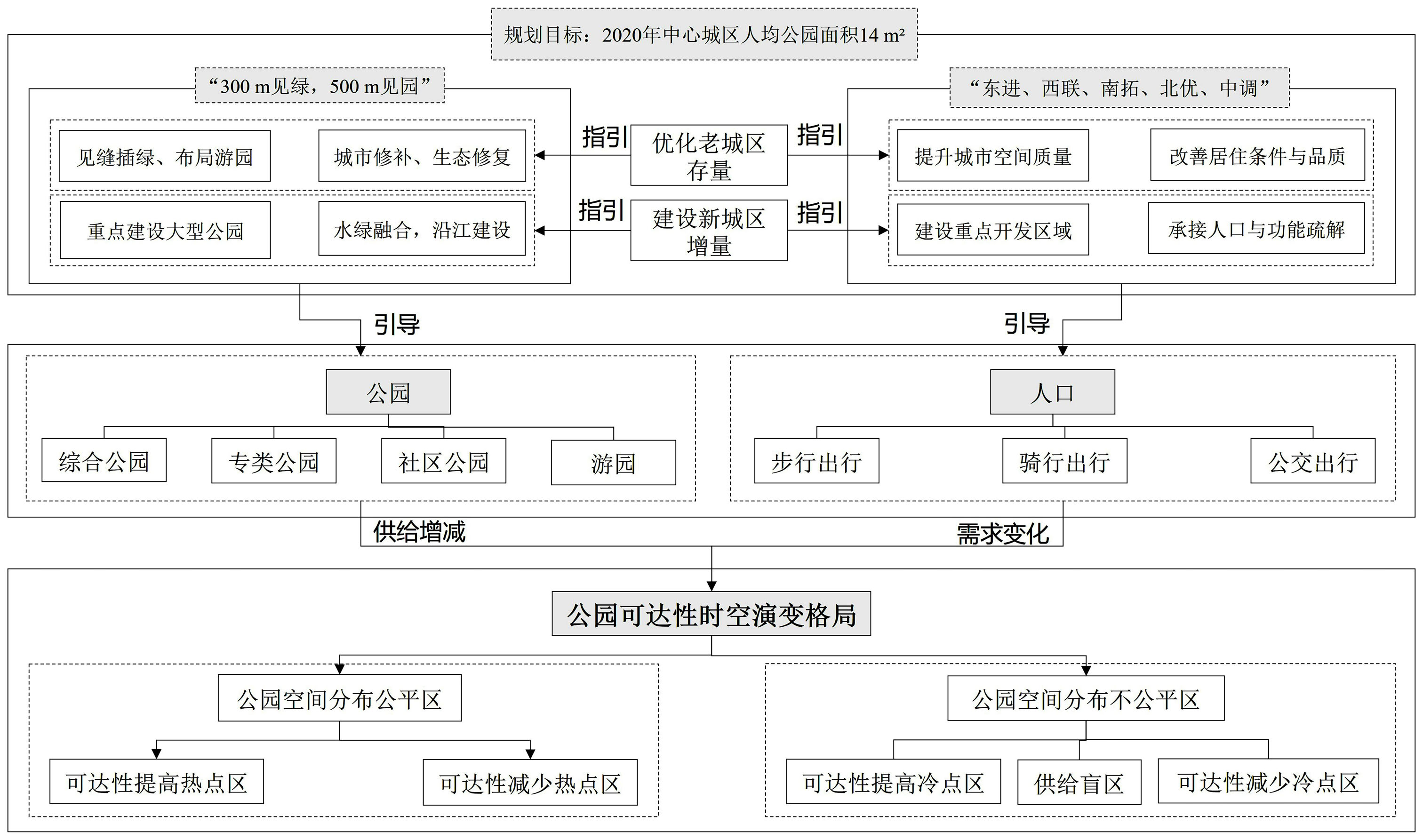
The rationality of the spatial distribution of parks plays an important role in measuring cities' livability levels, promoting residents' physical and mental health, and promoting social interaction. However, with the continuous progress of urbanization and the rapid growth of the population, the contradiction between the supply of parks and the demand of people has become increasingly prominent. Moreover, the balance of the park layout did not receive enough attention when the urban population and residential spaces underwent dynamic transformations. This study analyzed the spatial and temporal evolution pattern of park accessibility in downtown Guangzhou in 2010 and 2020 using the Gaussian-based two-step floating catchment area (2SFCA) and hot-spot analysis methods. The results show that:1) From 2010 to 2020, the average accessibility of parks in downtown Guangzhou increased. The communities with reduced park accessibility are areas with significant population increases, such as central Tianhe, eastern Haizhu, parts of Baiyun, and southern Liwan. The communities with improved park accessibility are mainly key urban development areas, such as Huangpu and Baiyun. Park accessibility has also improved in the depopulated old town within the Ring Highway. With the expansion of the travel range, the blind area of park supply is significantly reduced, and "seeing the park in 15 minutes" is realized under the bus travel mode. 2) Between 2010 and 2020, there was a spatial clustering phenomenon in the accessibility of parks under three travel modes. The impact of travel modes on the spatial clustering degree of park accessibility is obvious, and the change of spatial autocorrelation caused by time evolution is weak. With the improvement of travel range, the hot-spot and the cold-spot areas gradually expand, and the spatial agglomeration characteristics become more obvious. The hot-spot areas are mainly located in the old urban areas along the Pearl River and the Ring Highway, while the cold-spot areas are mainly located in Liwan and the outer urban areas outside the Ring Highway. 3) Under the guidance of the urban planning policy and the government, the orderly construction of parks and population flow comprehensively form the fair and unfair areas of the park's spatial distribution. The park's spatial distribution unfair area is the key area of the park's future planning, construction, and quality optimization. From the spatial and temporal dimensions, the research results complement the impact of the travel mode and urbanization process on the accessibility of parks. It makes up for the deficiency of the previous studies, which are mostly horizontal to some extent. It also helps to provide guidance and suggestions for the planning and layout of parks and policymaking in cities with the same type of high-density population.
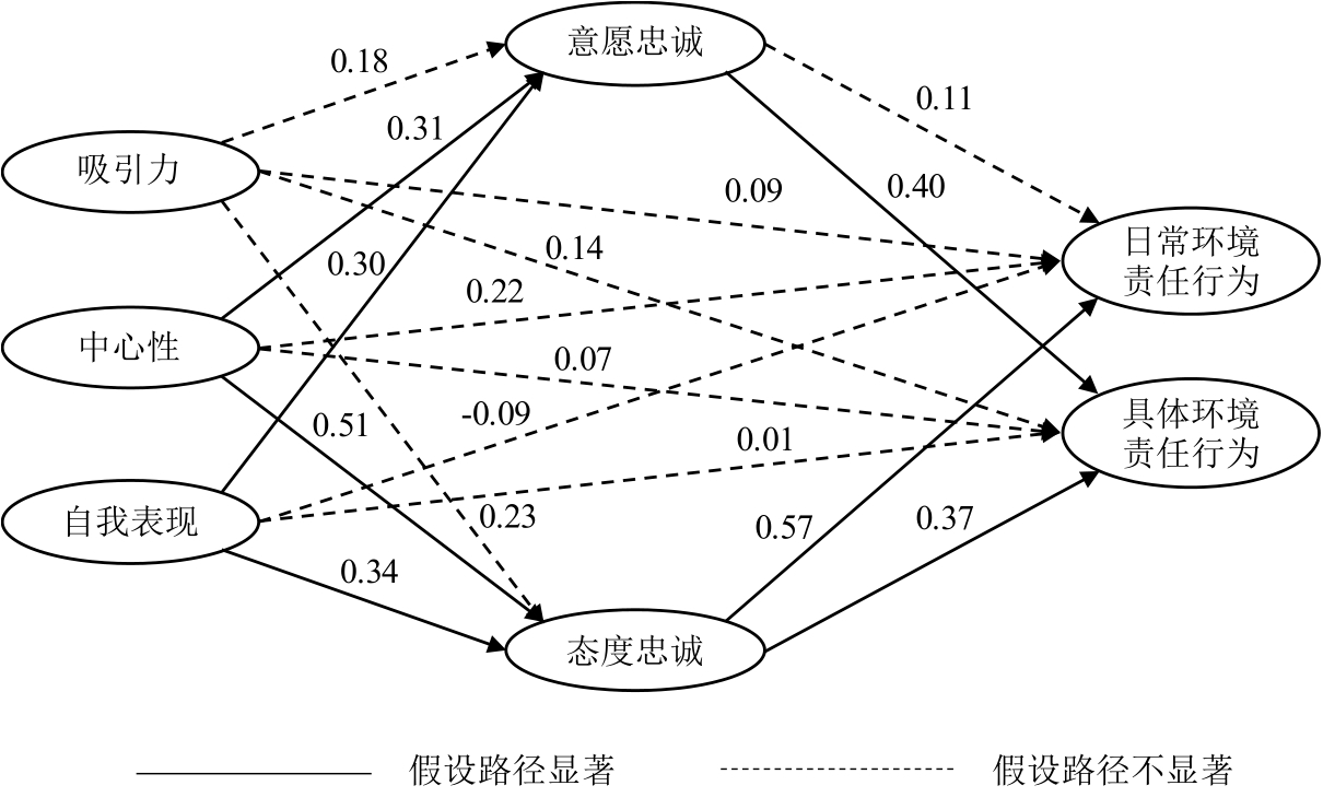
Situational factors affect the continuation and spillover of individual emotions and behavior. People's environmental-responsibility behavior in ecotourism situations can be difficult to extend to everyday life. Greenway leisure linked to everyday life provide new opportunities to cultivate people's environmental-responsibility behavior. In the context of greenway leisure, and based on the theories of self-perception and spillover, this paper argues that the impact of leisure involvement on loyalty can take one of two paths: surface "willingness loyalty" and deep "attitude loyalty." Environmental-responsibility behavior during leisure activities can be divided into "specific environmental-responsibility behavior" and "daily environmental-responsibility behavior." The three dimensions of leisure involvement are also subdivided into, attraction, centrality and self-expression. The paper constructs a relationship model between leisure involvement,loyalty and environmental-responsibility behavior. Taking Zengcheng Greenway (a typical greenway-development project) as a case study, a questionnaire was distributed to 334 Greenway residents. The relationship between the three dimensions was empirically studied using a structural-equation model. The results were as follows: (1) The direct impact of various dimensions of residents' leisure involvement on environmental-responsibility behavior was not significant in greenway situations. This suggests that it may be important to cultivate deeper emotions among residents, as a way of evoking environmental-responsibility behavior in greenway situations linked to everyday life. (2) The "centrality" and "self-expression" associated with leisure involvement have a positive impact on specific environmental-responsibility behaviors during greenway leisure because they affect residents' willingness and attitude loyalty. However, only attitude loyalty can influence people's daily environmental-responsibility behavior. This result demonstrates the difference between willingness and attitude loyalty. Only the deep emotion of attitude loyalty can cause positive greenway-related attitudes and emotions about the environment to spill over into everyday life. (3) In the greenway context, the "attraction" dimension of leisure involvement has no significant impact on loyalty, primarily because people's pleasant perceptions and experiences of greenway leisure are highly substitutable, making it difficult for them to produce loyalty emotions. The present study proves that leisure involvement and attitude loyalty can be strengthened to improve residents' overall environmental-responsibility behavior. On this basis, it also proposes targeted countermeasures and suggestions for the current Greenway Construction. The first step is to strengthen the connectivity of urban, rural, and ecological greenways, emphasizing the role of greenways in travel, leisure, and ecological protection, and improving the status of greenways in people's daily lives and leisure activities. The second step is to endow the greenway with more diversified cultural attributes, so that people can find their own cultural preferences and personality expressions. Third, the experiences and forms of creative expression associated with the greenway should be actively strengthened, giving it a unique "selling point" to cultivate people's understanding of greenway attitude loyalty. Future research should explore urban recreational spaces, recreational belts around cities, and other leisure sites. It will be important to identify differences in the paths used to form environmental-responsibility behavior in these contexts, compared with greenways.
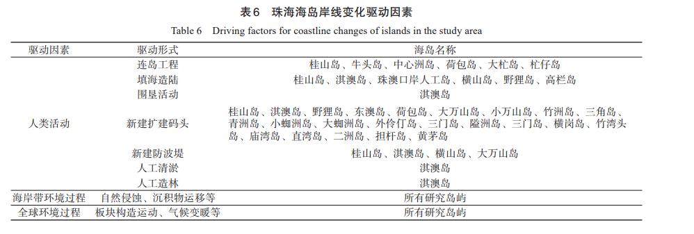
The change of the coastline has an extremely important impact on the safety of the wharf and port, the ecological environment of the island and the development of coastal industries. Therefore, analyzing the temporal and spatial evolution characteristics of island coastlines and its driving factors is of great significance for government to strengthen coastal management, improve the environment quality of islands, and maintain sustainable development of islands. Research selected the Landsat satellite data of Zhuhai City in 7 years from 1986 to 2021, employed the MNDWI and manual visual interpretation to extract the coastal waterline of the island, and analyzes the changes in the length of the coastline and the area of the island in each time period. As a result, the research objects are divided into islands with slight coastline changes and islands with significant coastline changes. DSAS module and multi-source data are employed to explore the driving factors affecting the temporal and spatial changes of island coastlines. The conclusionsare as follows: 1) In the past 35 years, the coastline length of each island in Zhuhai City has changed significantly, and the change trend of each island area is different. 2) The island has undergone large-scale construction activities in the past 35 years, and the coastline has changed significantly. The LCI in each period is in the range of 1.1-2.2, and the ACI is in the range of 1.1-3.3; the island has a slight coastline change due to the development disadvantages and island protection policies determined by the natural conditions of the islands, the degree of island development is low, the coastline changes slightly, and the LCI and ACI in each period are within the range of 0.9-1.1. 3) Human activities are the direct driving factor affecting the change of the island coastline, and the specific manifestations are island-connecting projects, land reclamation, and construction of wharfs. The indirect drivers of shoreline change are macroscopically the development of islands as a key driver of Zhuhai's marine economy and the human activities brought about by industrial development that affect shoreline change. Microscopically, the related island has the potential to develop related industries or contains rare ecological populations that need to be protected, and the resulting construction projects such as reclamation,island linkage or urban planning policies affect the island's shoreline change.Research departs from the micro perspective of existing studies at the research scale and takes a medium to macro perspective by selecting 66 islands in Zhuhai to explore the commonalities and characteristics of shoreline changes in each island.In terms of analysis depth, study combined government planning documents at various stages of Zhuhai City to deeply explore the indirect impact of planning on shoreline changes, which was rarely discussed in existing studies. This research can provide more comprehensive data support and reference materials for Zhuhai and the GBA to formulate island development strategies, and has practical and academic value.
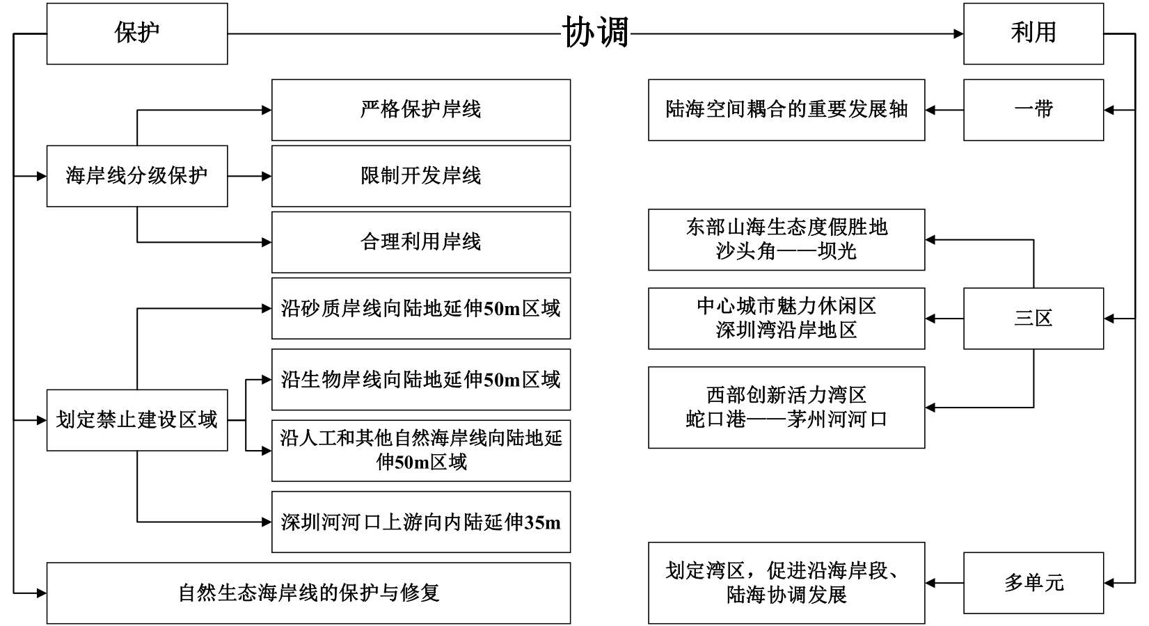
Since the reform and opening-up, the ecological environment of the coastline of Shenzhen has been under pressure from high-intensity human exploitation activities. Additionally, the structure, type, and length of the coastline has undergone significant changes. Studying the changes of the Shenzhen coastline over the past 40 years is helpful to reveal its spatial and temporal evolutionary processes and driving mechanisms to provide a reference for the protection and utilization of coastline resources. This study screened 16 scenes of the Shenzhen regional Landsat remote sensing images from 1979 to 2019, and performed a coastline extraction using Remote Sensing (RS) and Geographic Information System (GIS) methods to ensure alignment, accuracy, and extraction precision to meet the research requirements. Based on four coastline evaluation indexes (End Point Rates, Linear Regression Rates, Coastline-type Diversity Index, and Comprehensive Index of Coastline Utilization), the spatiotemporal characteristics of the coastline length, structure, types, and rate of change were analyzed to explore the factors driving the spatio-temporal evolution of the Shenzhen coastline. The results found that over the past 40 years, (1) the length of the Shenzhen coastline has experienced a continuously increasing trend, with a total increase of 41.52 km, and an average annual growth of 1.04 km. All the natural coastlines within the coastal area of Shenzhen decreased significantly to varying degrees, with a total decrease of 56.61%, while the proportion of artificial coastlines increased rapidly. (2) The change in coastline type in Shenzhen is mainly from the early muddy and sandy coastline to the farming reclamation and engineering construction coastline, i.e., the transition from natural to artificial shore. Among them, coastline length increased the most from 1979 to 1988. The most drastic coastline change was observed from 1979 to 1994, and the peak period of land reclamation was from 1994 to 2008. After 2008, Shenzhen coastline development gradually entered a sustainable and rational stage. (3) The spatial vicissitudes of the Shenzhen coastline have progressed through the stages of initiation, acceleration, and rational restriction. Areas with significant coastline expansion were located in Bao'an International Airport, Qianhai Cooperation Zone, Shenzhen Bay of Houhai, Yantian District, and near Longqi Bay. The change in the west coast of Shenzhen is more drastic than that of the east coast. The maximum rate of change (EPR) on the west coast reaches 422.19 m/a, which occurred during the Shekou Peninsula seaward extension period from 2004 to 2008. The EPR on the east coast reached the highest level of 449.65 m/a during the development and construction of Yantian Port from 1994 to 1998; and (4) the Shenzhen coastline change is a dynamic and a continuous process of change. Human activities, special zone policies, and natural factors were the main driving forces of the coastline changes. The special zone policy is the core driving force for Shenzhen's population expansion, urban sprawl, and the fundamental reason for the reduction in natural coastlines and the growth of artificial coastlines. This study provides important guidance for future sustainable urban development in Shenzhen.