In response to global climate change, China has incorporated carbon peaking and carbon neutrality into its overall economic and social development. National-level new areas are critical strategic carriers for high-quality regional economic development in China, playing an essential role in promoting carbon reduction. Objectively evaluating the carbon-emission-reduction effect of national-level new areas can help accumulate and promote China's low-carbon construction experience, and thus, comprehensively facilitate greening and ecological civilization construction. In this study, the impact of the establishment of national-level new areas on carbon emissions in their respective cities were investigated using the difference-in-difference method. The findings show that: 1) the establishment of a national-level new area can significantly minimize the carbon emissions in the city in which it is located, and after three years of establishment, it will have a significant long-term inhibitory effect on the carbon emissions of the city. This conclusion is still valid after a series of robustness tests, such as propensity score matching + difference-in-difference; 2) The national-level new area policy mainly reduces carbon emissions in a city through technological and energy-saving effects but cannot yet reduce them by adjusting the industrial structure. 3) The impact of the establishment of national-level new areas on the carbon emissions of surrounding cities shows an "∽" trend of increasing first, then decreasing, and subsequently increasing. It has a significant carbon-reduction effect on cities within the range of 200-250 km, indicating that national-level new areas can help promote carbon-emission reduction in surrounding cities. 4) The national-level new area policy has a higher carbon-emission-reduction effect on northern cities than on southern cities. The single-city layout model of the national-level new area has a significant carbon-emission-reduction effect on the host city, whereas the dual-city layout model does not significantly reduce the carbon emissions in the host city. This study investigated the carbon-emission-reduction effect of national-level new area policies and examined carbon-emission reduction in the national-level new areas of pilot cities through technological and energy-saving effects. This study helps to improve the theoretical understanding of national-level new area policies and carbon-emission impact mechanisms and provides a policy reference for China's promotion of the "dual-carbon" strategy.
China has entered a critical period of economic transformation and rapid development. In this context, it is important to promote the coordinated emission reduction of carbon dioxide and environmental pollutants, transformation of the economic growth model, realization of the "double carbon" goal, and high-quality economic development. Within the framework of the synergy of pollution and carbon reduction, we constructed a comprehensive evaluation index system and used the improved TOPSIS model to measure the synergy index of pollution and carbon reduction in urban agglomerations within the period from from 2010 to 2019. Combined with spatial autocorrelation analysis, a composite system synergy model, and a regression model, the spatial and temporal evolution laws and collaborative development level of the synergy of pollution and carbon reduction in urban agglomerations were analyzed, and the factors influencing the synergy between pollution and carbon reduction were explored. Following conclusions were drawn from the results. (1) From 2010 to 2019, the synergistic effect of pollution and carbon reduction in three major urban agglomerations showed a steady growth trend, with different spatial distribution patterns. The synergistic index of pollution and carbon reduction in the Yangtze River Delta urban agglomeration shows an overall upward trend, that in the Beijing-Tianjin-Hebei urban agglomeration shows a steady fluctuation, and that in the Pearl River Delta urban agglomeration shows a slow growth trend. (2) The spatial correlation characteristics of the Beijing-Tianjin-Hebei urban agglomeration change from random to regular distributions, and the synergistic cooperation mechanism of pollution and carbon reduction among cities in the Yangtze River Delta urban agglomeration needs to be strengthened. The radiation and driving effect of the cities in the Pearl River Delta urban agglomeration on the surrounding cities is gradually increasing, and the local spatial agglomeration of these three major urban agglomerations is not evident. (3) From 2010 to 2019, the order degree of the synergistic system of pollution and carbon reduction showed a significant growth trend; the overall synergy degree of the composite system is low, and the growth order of the urban agglomerations is as follows: Yangtze River Delta > Beijing-Tianjin-Hebei > Pearl River Delta. Different evolution and correlation characteristics are observed in space, and no internal coordination of urban agglomerations is seen. (4) Economic development, environmental pollution, environmental governance, ecological protection, and resource utilization are important factors affecting the synergistic evolution of pollution and carbon reduction in the three aforementioned major urban agglomerations. This study analyzed the connotation requirements and specific characteristics of the synergy between pollution and carbon reduction in such agglomerations in the coastal areas of China. Based on the analysis of the spatial and temporal evolution and influencing factors of the synergy of pollution and carbon reduction in these agglomerations, we aim to address the problems existing in the synergy of pollution and carbon reduction in urban agglomerations. Corresponding countermeasures and suggestions are put forward to provide an empirical reference for the realization of comprehensive green and low-carbon transformation and high-quality green development of urban economies and societies.
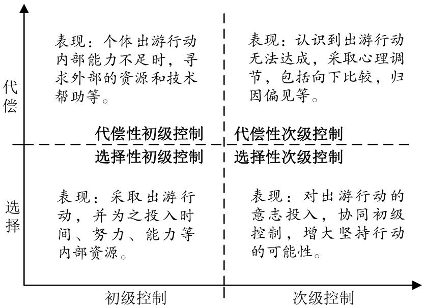
The autonomy and travel conditions for older adult tourists have significantly improved, leading to a diversification of their tourism activities. Among these, the concept of a free and comfortable sojourn has gained popularity. Despite the complex concept of older adult sojourns being established in related research, the concepts often overlap and are fragmented, leading to a disjointed understanding of the phenomenon. This study aims to incorporate the life-span theory of control and its optimization strategy framework from a life-span development perspective in older adults. By deeply connecting research on older adults with tourism research through life-span development thinking, we aim to explore methods of coordinating and analyzing older adult sojourns. This approach will allow us to systematically reshape existing conceptual knowledge. Based on the results of this coordinated analysis, we aim to gain a systematic understanding of older adult sojourns and propose future research directions. The study revealed that older adult tourism exhibits strategic traits consistent with the life-span theory of control, where resource allocation and willpower investment are crucial elements. This forms a resource-willpower investment framework that categorizes 16 different older adult tourism behavior patterns. Using this framework, by comparing the characteristics of older adult travel with the 16 classification results, the resource and willpower investment framework is focused on the amount of resources invested in the destination and the distance of the trip. This further refines the corresponding older adult travel patterns into four types: relatively high investment in travel to distant areas, relatively high investment in travel to nearby areas, relatively low investment in travel to distant areas, and relatively low investment in travel to nearby areas. The study reveals that the four categories represent varying lifestyle demands and participation limitations for older adults. Those who invest more and travel longer distances tend to face greater participation challenges, have fewer companions, require more from their destinations, and have limited choices. Conversely, those who invest less and travel shorter distances experience the opposite. The four categories of older adult travel display different scene transitions and state changes, each with unique participation challenges, social choices, and destination requirements. Overall, the categorization of older adult tourism types and the comprehensive analysis of older adult travel types constitute a process of knowledge creation. The research employs deductive methods for progressive exploration, building a comprehensive classification framework. This framework lays a cognitive foundation for future research and provides key directions. The innovative research approach, in conjunction with the life-span theory of control, provides a method for pattern analysis to understand ongoing tourism behaviors and phenomena that are constantly evolving and enriching. Older adult sojourn is one of the few forms of tourism that is notably age-friendly. The prospects for research and industrial development of this phenomenon are promising, but there is currently a lack of discussion about the phenomenon itself. Future research can build upon this initial understanding to further investigate behavioral characteristics, values related to aging, and local response needs. By examining behavior, subject, and space, a study can be conducted on behavior, motivation, space, and their interactive results, leading to more systematic findings and enhancing the practical value of the guidance.
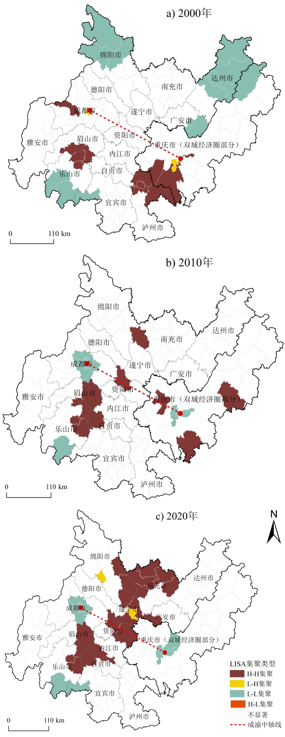
Based on the National Census data of 2000, 2010, and 2020, with districts and counties as spatial units, the current situation of population aging is described using a time-series comparison method, and its distribution position is identified using a standard deviation ellipse. Moran's I index was used to investigate the spatial correlation and evolution characteristics of population aging, and the Dagum Gini coefficient and decomposition were used to evaluate its regional differences and sources. Then, a spatial econometric regression model was used to test the factors influencing the spatial differentiation of population aging. This study revealed that the population aging of counties in the Chengdu-Chongqing economic circle has been accelerating as a unit from 2000 to 2020. However, different regions before and after 2010 have shown relatively different changes. The center of population aging in the counties gradually shifted to Chengdu over time. Population aging in counties of the Chengdu-Chongqing economic circle mainly shows the spatial distribution characteristics of similar types of agglomeration; counties with significant spatial correlation are mainly characterized by high-high or low-low type clustering, of which the latter has gradually concentrated in Chengdu and Chongqing during the survey period. After 2010, the high-high type clustering areas rapidly concentrated on the two wings of the central axis of Chengdu and Chongqing. The overall difference in population aging of the counties in the Chengdu-Chongqing economic circle accelerated during the investigation period. The increase and decrease in intra-regional differences varied among different periods, with increased inter-regional differences occurring after 2010. Hypervariable density contributed the most to the overall difference in population aging. Compared with 2010, factors such as aging inertia, fertility inertia, population inflow, and education level had a greater impact on the spatial differentiation of population aging in the Chengdu-Chongqing economic circle in 2020, and an increasing number of elderly people have been observed to gather in more densely populated districts and counties since 2010. Overall, this study provides a detailed presentation of the spatial imbalance and dynamic evolution characteristics of population aging at the county level in the Chengdu-Chongqing economic circle over the past two decades and reports that, compared to 2000-2010, the population aging in the counties of the Chengdu-Chongqing economic circle during 2010-2020 underwent rapid deepening with an overall increase in differences and showed new changes in deepening speed, regional relative aging degree, and distribution of similar types of agglomeration counties, that could be considered, there are also certain differences in the causes of population aging in the counties.
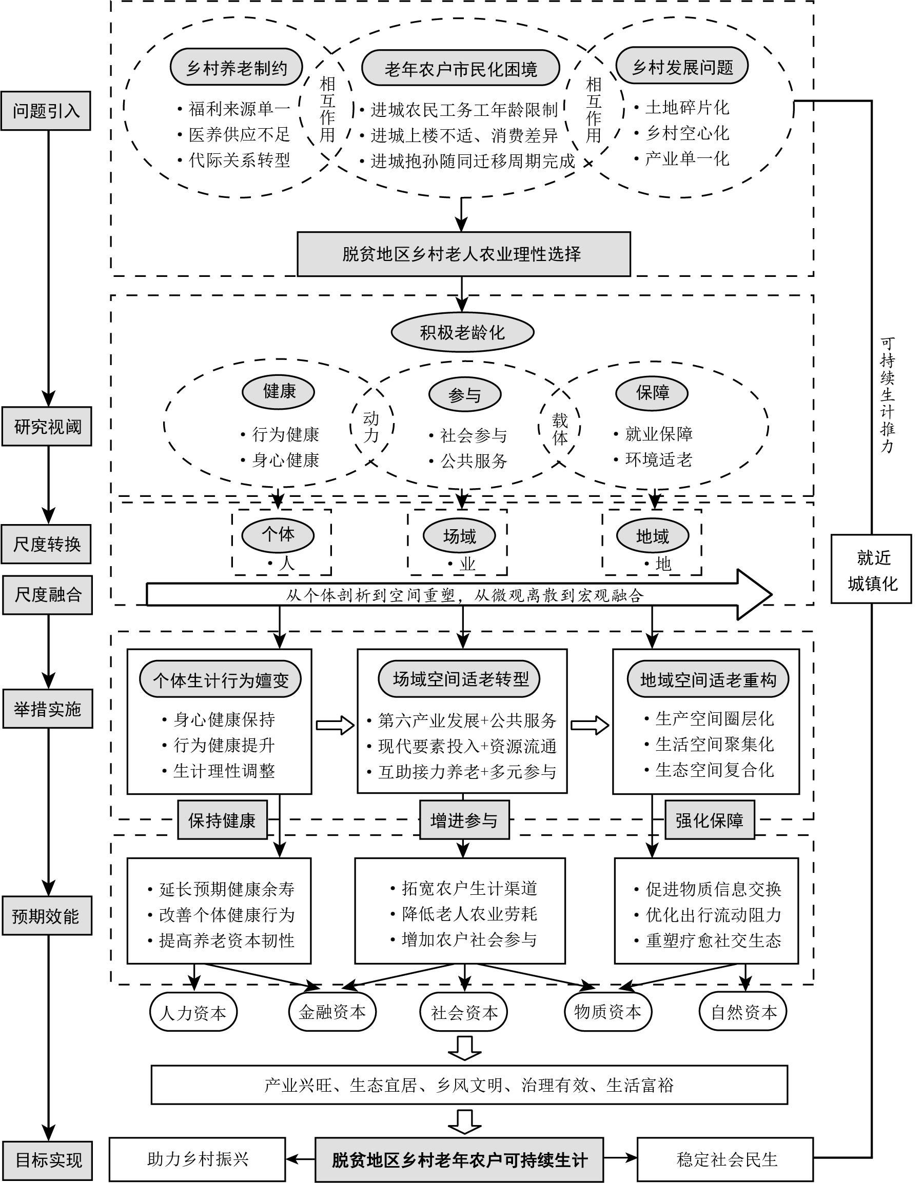
The phenomenon of population aging has become an important issue affecting the sustainable economic and social development of China's countryside, but few studies exist within the academic community on the sustainable livelihoods of rural elderly farmers in areas of poverty alleviation. Based on a 2022 field survey in Guzhang County, Hunan Province, this study examined the sustainable livelihood pathways of elderly rural farmers in these areas through non-participant observations, semi-structured interviews, and grounded theory methods of textual analysis. Study findings show that in the face of rural hollowing out caused by the outflow of the young labor force due to rapid urbanization, a large number of rural elderly farmers in poverty alleviation areas are facing the livelihood dilemma of rural pension structure constraints and the rational choice of agriculture. The background for this situation involves the insufficiency of the original pension model and multiple welfare sources, a shortage of medical and health service facilities, and the transformation of intergenerational relations. Therefore, based on the advantages of rural social networks in poverty alleviation areas in the three active aging dimensions of health, participation, and guarantee, this paper presents a sustainable livelihood research paradigm in which the individual, rural, and socioeconomic networks and rural production-living-ecological space of elderly farmers in poverty alleviation areas coordinate with each other. The paper also introduces a logical framework for the sustainable livelihood of elderly farmers that is consistent with the goal of rural revitalization through the thrust of nearby urbanization. Specific sustainable livelihood paths integrating individual spaces include the following: 1) at the individual level, through the individual livelihood behavior and livelihood capital of elderly farmers dynamically adjusting to the corresponding sources of welfare and livelihood modes with changes in the life cycle, 2) at the field space level, through the sixth industry, integrated development of modern factors intervening in the establishment of rural market industrial support to cope with aging, and 3) at the territorial space level, according to the rural elderly. The social circle structure of rural households is used to reshape the living, production, and ecological aging life circle. This study analyzed the sustainable livelihood paths of rural elderly farmers in poverty alleviation areas from individual to spatial perspectives The findings provide a theoretical basis and practical references for the revitalization of rural people in these areas in the era of rapid aging.
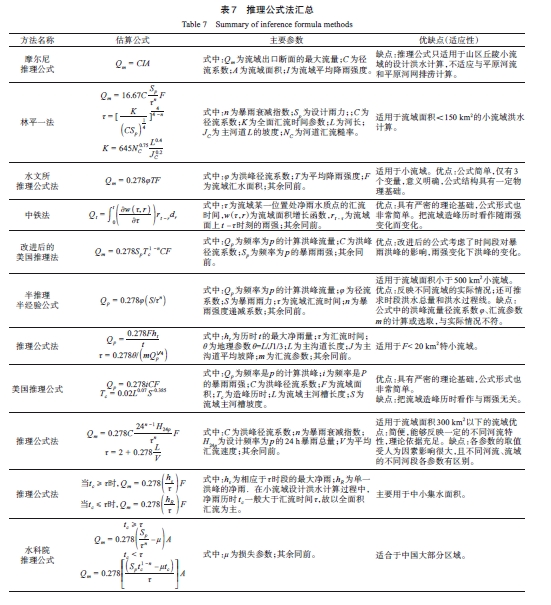
The prediction of rainstorms and floods in small and medium-sized watersheds, as well as the synthesis of related parameters, plays a pivotal role in preventing flood disasters. Environmental changes have led to an increase in hydrological extremes such as rainstorms and floods, presenting unprecedented challenges for small and medium-sized river basins. In this review, we systematically categorize, and summarize the processes involved in predicting rainstorms and floods in these watersheds, along with advancements in correlated parameter synthesis research. Furthermore, we analyze and discuss the most commonly employed runoff and confluence estimation methods and their associated parameters in practical applications, as well as their limitations. First, we establish the concept of small- and medium-sized watersheds across various academic disciplines. From a hydrological perspective, these watersheds typically exhibit slope confluence and have relatively small catchment areas. In terms of eco-hydrology, the ecological water demand of the basin must be calculated based on the different communities occupying the river basin and divided by area according to the ecological samples from each district after the investigation. Thereafter, we summarized the methods and types of runoff calculation and parameter synthesis in small- and medium-sized basins, and the methods and principles of runoff analysis, such as rainfall–runoff correlation diagram, infiltration curve method, deduction method, runoff coefficient method, and hydrological model method as well as the methods of parameter synthesis, such as rainfall-runoff correlation diagrams and loss methods are introduced. Second, we summarize and discuss the assessment of confluence and its associated parameters in small- and medium-sized river basins. This encompasses background information and various calculation methods, such as the instantaneous unit line, comprehensive unit line, inference formula method, and empirical formula method. We also examine how the three major elements of parameter synthesis convergence influence confluence parameters. We emphasize that combining radar rainfall measurements, high-resolution remote sensing, high-performance computing, and deep learning can facilitate research on simulating and forecasting rainstorms and flood processes in small- and medium-sized basins. However, a significant portion of these basins lacks data, limiting the application of simulation and flood forecasting. To address this, integration with geographical parameters specific to small- and medium-sized basins is necessary to enhance regional reliability and forecasting accuracy. Additionally, when applying deep learning to simulate basins with limited or no data, the significance of parameter synthesis becomes even more pronounced. Finally, we discuss the problems and challenges associated with storm flood calculations and parameter synthesis methods in small- and medium-sized basins and offer predictions regarding future research and technical developments. We recommend strengthening the use of emerging technologies for watershed runoff and runoff parameter calculations and advocate for their application in storm flood design.
Small and medium-sized mountain rivers have characteristics of short processes, rapid flow rates, and quick responses to extreme weather, thereby playing an important role in the global marine geochemical cycle. Understanding the changes in water and sediment characteristics of small and medium-sized rivers in response to extreme weather can provide scientific support for disaster prevention and mitigation and channel management of river basins. This study analyzed data from the past 60 years to understand the variations in the characteristics of water and sediment in the Qinjiang River of the Beibu Gulf under extreme weather conditions by estimating their variation coefficients and contribution rates. The results of the analyses show the following: (1) The Qinjiang River has an average discharge of 32 and 290 m3/s in normal and tropical cyclone weather conditions, respectively. During a tropical cyclone year, the average flow rate is 9.06 times that during normal weather. The average sediment transport rates during normal weather and tropical cyclones are 0.05 × 10⁴ and 1.15 × 10⁴ t, respectively, wherein the latter is 23 times higher. (2) The average flow rates during normal weather and flood periods are 375 and 2,725 m3/s, respectively; the latter is 7.27 times higher. The average sediment transport rates in normal weather and flood period are 0.07 × 10⁴ and 1.14 × 10⁴ t, respectively, wherein the latter is 16.28 times higher. (3) The average annual contribution rates of tropical cyclones and floods to the runoff and sediment discharge of the Qinjiang River are 10.75% and 20.95% and 16.75% and 30.07%, respectively. Extreme weather contributes significantly to the variations in the water and sediment characteristics of the Qinjiang River. During extreme weather, the Qinjiang River exhibits a surge of water and sediment with inter-annual variations. The peaks of runoff and sediment transport during the transit of tropical cyclones tend to decrease gradually over the years, probably because of the reduction in the impact of their activities. The Qinjiang River is located in the South China Sea. The under construction western land-sea new passage grand project, namely the Pinglu Canal, will provide access to the Beibu Gulf along the Qinjiang River. The results of this study will provide scientific support for the disaster prevention and mitigation of the Pinglu Canal and the construction of the port.
Quantitative studies of mangrove leaf functional traits will help us understand the adaptive evolutionary strategies of mangrove plants and the relationship between mangrove biodiversity and ecosystem functions. Because of the special environment of the intertidal zone where mangroves are located, it is very difficult to obtain the functional traits of mangrove canopies from the ground, and relevant studies are lacking. The maturity of Unmanned Aerial Vehicle (UAV) hyperspectral remote sensing technology provides a new means of conducting such research. This study considered mangroves on Qi'ao Island, Zhuhai, as the research object. Based on UAV hyperspectral data, two UAV hyperspectral data processing methods, which combined Partial Least Squares Regression with Normalized Difference Vegetation Index (PLSR+NDVI) and Partial Least Squares Regression with Continuous Wavelet Transform (PLSR+CWT), were used to estimate the 10 canopy leaf functional traits of mangroves on Qi'ao Island. The results showed that the PLSR + NDVI method was more suitable for the inversion of mangrove canopy-specific leaf weight (LMA), phosphorus content per unit mass (Pmass), and nitrogen content per unit area (Narea), whereas the PLSR + CWT method was more suitable for the estimation of the nitrogen/phosphorus ratio (N/P), chlorophyll content (Cab), and carotenoid content (Cxc). However, the results of the above two methods for retrieving the nitrogen content per unit mass (Nmass), potassium content per unit mass (Kmass), phosphorus content per unit area (Parea),and potassium content per unit area (Karea) were not ideal (R2<0.3). The optimal method established in this study was used to estimate the contents of LMA, Pmass, Narea, N/P, Cab, and Cxc of the mangrove canopy leaves in the study area and map their spatial distribution. Mangrove canopy leaf functional traits obtained using UAV hyperspectral data inversion better reflect the horizontal structure and function of the mangrove community. Regarding the spatial distribution patterns of canopy leaf functional traits, the spatial distribution patterns of Narea, Cab, Cxc, and N/Pwere relatively consistent with higher values in the middle region and lower values in the edge region. The spatial distribution patterns of the LMA and Pmass were similar, and the distribution was relatively uniform throughout the study area. Combined with ground survey data, the internal relationship between species composition and spatial patterns of functional traits, as well as ecosystem functions and processes, can be deeply explored, and rapid investigation and assessment of mangrove forests can be realized at the community and ecosystem scales. The spatial distribution pattern of functional traits was closely related to the spatial distribution pattern of canopy structure and species. The inversion model of hyperspectral functional traits was constructed by separating mangrove species with different life types, which is expected to further improve the inversion accuracy of the model. Constructing a specific functional trait inversion model for each mangrove species, combined with the species identification results of visible-light images, will effectively improve the inversion accuracy of mangrove canopy leaf functional traits.
Mangroves are typical ecosystems located in the intertidal zone of tropical and subtropical coasts that protect the area against wave action, promote accretion in river estuaries, and act as an important global carbon sink. However, several natural mangroves have recently degraded due to climate change and human activities, increasing the risk to coastal areas' ecological environments. The mangroves on Qi'ao Island in Zhuhai, China, have been destroyed by human activities and the invasion of the exotic species Spartina alterniflora. In 1999, the Zhuhai municipal government imported pioneer species, such as Sonneratia apetala, to Qi'ao Island to restore the degraded mangroves, which have now evolved into a sufficiently continuous community with a stable area since 2015 with S. apetala as the dominant species. However, because the intensity and frequency of typhoon landfalls are increasing under global warming, dominant species in the mangroves of Qi'ao Island, S. apetala, is more vulnerable to typhoon disturbance due to its height and low trunk density, leading to greater uncertainty regarding their ecological functions on Qi'ao Island. Existing studies have mainly focused on the damage and recovery patterns of mangroves by a single typhoon, having seldom analyzed the response process of mangroves to consecutive disturbances by multiple typhoons; thus, these studies cannot be used to predict the succession process of mangroves with increasing typhoon frequency. In this study, the damage and recovery patterns of mangroves on Qi'ao Island were studied under the disturbance of three consecutive typhoons (2016 NIDA, 2017 Hugo, and 2018 Mangkhut), and their influencing factors were discussed based on the Normalized Difference Vegetation Index (NDVI) using Sentinel-2 remote sensing images. The results showed that (1) the NDVI of mangroves on Qi'ao Island decreased after the typhoon, and the damage levels could be classified as mild or mild to moderate. Moreover, the severity of the damage was relatively small. (2) An annual legacy effect existed across multiple typhoons. The recovery process of mangroves generally followed a circulating succession mode after typhoon disturbances in the order of more severe damage→slow recovery→milder damage→rapid recovery→ more severe damage pattern. (3) The damage levels of mangroves on Qi'ao Island increased with typhoon intensity. However, they decreased if S. apetala recovered slowly before the typhoon. Thus, the recovery pattern was mainly influenced by the damage levels of S. apetala after the typhoon landing and was not largely dependent on the hydrothermal conditions at regional scales. The results suggest that mangroves on Qi'ao Island, mainly consisting of S. apetala,have evolved to adapt to the consecutivetyphoon disturbances, which has promoted their succession from plantations to near natural forests and the formation of a stable typhoon-resistant ecosystem.
Mangroves are halophytic forest plant communities located on saline marshes in estuaries of tropical and subtropical bays. They are one of the most vulnerable ecosystems in the world and are severely threatened by urban development, environmental pollution, aquaculture, and other problems. The Dongchong mangrove forest is a relatively well-preserved mangrove forest in China, with a large area and a typical Excoecaria agallocha landscape, which has significant ornamental and ecological conservation value. The aim of this study is to provide basic support not only for mangrove ecological conservation and restoration, but also to construct and manage nature's reserves. The eco-environmental geological characteristics of mangroves were investigated using geology, geomorphology, pedology, ecology, and other methods, and a typical eco-environmental geological profile of the mangrove in Dongchong was drawn. The results show that the strata in the study area are mainly Quaternary sediments and rhyolites of the Nanshancun Formation of the Early Cretaceous. Faults are developed in the west of Dongchong Mangrove Wetland Park. The main environmental geological problems are uneven ground settlement, ground subsidence, and ground cracks. The concentration of F- in the surface water are high, and the water quality is slightly lower than that of the Class III water standard; however, the groundwater is freshwater with low salinity and hardness. Cd and Tl are locally significant in the surface soil of the study area. N, P, CaCO3, Org, and B are deficient in the soil, whereas the K content is mainly medium. A part of the soil is polluted by heavy metals, particularly As, followed by Cd. However, the mangrove leaves are rich in nutrients, indicating that the lack of soil nutrient elements and heavy-metal pollution are not the major factors limiting the growth of mangroves in this region. Improving the growth environment of mangroves should include expanding the landscape area and reinforcing reserve management. In the rock-soil-plant ecosystem, As, Pb, Cd, and B are significantly rich in the soil, indicating that their contents have a slight correlation with their parent rocks. Ni, Cu, Zn, and K are limited by the parent rock contents, and some elements including P, Mo, and Cr show enrichment capacity in the soil. The BCF >2 of mangroves of the mangrove forests in Dongchong are P and B, indicating that the mangrove trees have a higher absorption capacity for P and B. In contrast, the BCF values of As, Pb, and Cd are relatively low, which, in addition to the weak absorption capacity of the mangrove trees for these elements and combined with the geochemical characteristics of the soils in the study area, are also affected by the high Cd and As contents of the soil. All the data presented in this paper are from the project, "Ecological and Environmental Geological Survey of Shenzhen Nature Reserves," for which we express our sincere gratitude.
Memory is an essential structure of the tourism experience. Tourism memory construction is not only an individual's review and sublimation of on-site experience, but also the pursuit and introspection of self-meaning. Although tourism memory is unique and critical, it has not yet been fully examined in local tourism studies, resulting in the focus on on-site experience while ignoring the special role of tourism memory in shaping the landscape and constructing individual self-cognition. In this study, based on theories of autobiographical memory and self-expansion, the Grounded Theory and Structural Equation Model were adopted to investigate the influence mechanism of tourism memory construction on tourists' self-concept expansion based on excavating the dimensions of tourism memory construction. The results showed that: 1) Tourism memory is an unforgettable autobiographical memory formed by individual screening and construction after tourists' on-site experience. Its construction dimensions comprise three basic structures: cognitive appraisal, interactive perception, and affective involvement. Specifically, cognitive appraisal refers to the cognitive feelings generated by tourists based on the objective environment of destinations in their memory. Interactive perception is the participatory perception of the interaction between the host and guest and the interaction between tourists. Affective involvement reflects the emotional properties of memory, which is the corresponding emotional reaction of tourists based on cognitive appraisal and interactive perception. These three elements are interrelated and jointly shape and interpret the landscape constructing tourist' self-identity. 2) Cognitive appraisal, interactive perception, and positive affective involvement in tourism memory help promote tourism-sharing behavior, which significantly and positively influences the individual and social self-expansion of tourists. This finding confirms that cognitive and interactive memories contribute to tourism-sharing behavior. In particular, positive and negative affective involvements are remembered by tourists, but many tourists are more willing to share "positive energy" and express the positive side of tourism memories. In addition, through self-narration and self-expression, tourism sharing deepens reflection of the overall self-perception. 3) Among the direct effects of tourism memory construction on self-concept expansion, cognitive appraisal and interactive perception significantly and positively affect individual and social self-expansion, whereas positive affective involvement only positively affects individual self-expansion and indirectly affects social self-expansion by tourism sharing. Furthermore, this paper theoretically clarifies the dimensions of tourism memory construction, complements the theoretical deficiencies of post-travel memory in previous tourism experience studies, and reveals the subjective significance of tourism memory to self. This paper also introduces the concept of self-expansion in tourism research and complements self-expansion studies in nonrelational contexts. Finally, this study is a practical reference for memory marketing in destinations.
The acceleration of high-quality development in the revolutionary old areas has played a pivotal role in advancing coordinated regional development in China. The 20th National Congress of the Chinese Communist Party proposed a development strategy for implementing regionally coordinated development, building a new development pattern, promoting high-quality development, and accelerating the rejuvenation and development of special areas such as the revolutionary old regions. However, there is an overemphasis on economic development metrics, a disregard for local practices and characteristics, and a blending of processes and outcomes associated with the high-quality regional development evaluation indicators. To solve these issues, it is essential to establish a set of tailored indicators to evaluate and guide the high-quality and differentiated development of counties in the old revolutionary base areas. Harnessing the essence of high-quality development concept, this study proposes a logical framework for constructing an evaluation index system for high-quality development in counties within the revolutionary old areas. Using the old revolutionary base areas in Southern Jiangxi and Western Fujian as the study areas, a three-level coding process based on grounded theory was employed. This rigorous approach enabled the scientific construction of an evaluation index system for high-quality development in the revolutionary old areas. This index system comprises seven dimensions, namely, innovation-driven, economic development, urban-rural coordination, people's well-being, ecological civilization, internal and external openness, and red culture, encompassing 40 indicators. Furthermore, a critical understanding of high-quality development in the revolutionary old areas, emphasizing the need to inherit, preserve, and promote red culture as a contemporary task guided by new developmental concepts, was gained. The aim was to facilitate enhancing both the scale and structure of economic development. This indicator system uses the entropy method to ascertain the indicator weights and subsequently performs a comprehensive evaluation of the study areas. The findings indicate that innovation-driven factors play a significant role in driving the differences in the high-quality development of the revolutionary old areas. In contrast, ecological civilization is yet to exhibit sufficient potential as a driving force for high-quality development at the current stage. Notably, significant disparities exist in the level of high-quality development between the demonstration areas of Ganzhou and the old revolutionary base areas of western Fujian. These disparities are most evident in the spatial core-edge structure. Additionally, counties at the provincial boundaries demonstrate relatively low levels of high-quality development, warranting increased attention to future high-quality revitalization and development efforts. In comparison to previous research, this study contributes in three key ways. First, an evaluation index system has been constructed using a combined top-down and bottom-up approach, incorporating indicators that account for local practices and characteristics, offering a novel perspective for establishing a high-quality development index system. Second, the national strategic positioning of county-level research units in urban-rural integration development, rural revitalization, and urbanization is highlighted, with county towns identified as pivotal carriers. Urban-rural coordination was identified to be the focus of coordination at the county level. Finally, by extending the core connotations of high-quality development, this study enriches the existing understanding of high-quality development. The research findings hold significant implications for expediting the revitalization and development of revolutionary old areas and for the systematic implementation of high-quality development concepts.
With rural tourism playing a crucial role in rural revitalization, the transition of villagers' livelihoods in the early stage of tourism development has become the focus of academic circles, and the willingness of villagers to transition their livelihoods is of great significance for local transition and development. However, existing research is usually based on the framework of sustainable livelihoods and involves mainly five major livelihood capitals to explore the interaction between them and livelihood strategies. Thus, it fails to reflect the dynamic effect of the factors contributing to the villagers' willingness for livelihood transition. To solve this problem, this study takes Beigang village in Haikou as a case study and utilizes interviews, text encoding, and a fuzzy-set qualitative comparative analysis method to explore the factors influencing villagers' livelihood transition intentions to form the path and mechanism. The main conclusions are summarized as follows: 1) Policy guidance, tourist entry, human capital, sense of place, livelihood satisfaction, economic capital, and family pressure are the seven factors that mainly influence the intention of villagers' livelihood transition, while other factors include asymmetry, complex heterogeneity, and dynamic process characteristics. 2) Although tourist entry and a sense of place are necessary conditions to develop the willingness for livelihood transition, they are neither necessary nor sufficient. Based on the internal logic of the seven main factors, the formation path of villagers' willingness to transition to a new livelihood can be divided into three types: individual cognition-oriented paths, family responsibility-driven paths, and external environment-driven paths. 3) The development of the intention of villagers to transition to a new livelihood was analyzed for tourism development, in which the individual cognition-oriented path showed the highest degree of explanation, followed by the family responsibility-driven path and the external environment-driven path. The resident villagers who represent the individual cognition-oriented and family responsibility-driven logic want to realize the transition to tourism livelihood through "Part-time tourism," and have a relatively weak intention to transit their livelihood entirely. Non-resident villagers represent the logic of the external environment-driven path. They are eager to participate in tourism through "tourism-oriented" and strongly intend to transit their livelihood entirely. The difference between resident and non-resident villagers in the path of their intention at the subjective level shows a difference in their willingness, which is the main limitation to local livelihood transition. This study expands and enriches the literature on villagers' livelihood transitions, particularly for rural tourism. Moreover, it provides theoretical and practical implications for villagers to achieve sustainable development in tourism and livelihoods.

Northwest Hubei Province is a region prone to soil erosion. Investigating the spatiotemporal variations in soil erosion and identifying its underlying causes can offer valuable insights for guiding soil and water conservation efforts in the area. Based on the RUSLE model, we quantitatively analyzed the spatiotemporal variations in soil erosion in Northwest Hubei from 2005 to 2020. A geographical detector model was used to study the dominant factors of the spatial and temporal differentiation patterns of soil erosion, the degree of interactive coupling between multiple factors, and quantitative attribution of soil erosion-prone areas. The results indicate that, overall, the intensity of soil erosion in Northwest Hubei continued to decrease from 2005 to 2020. The average soil erosion modulus decreased by 16.3 t/(km2·a), and the soil erosion volume decreased by 200,000 t in 2020 compared to in 2005. Northwest Hubei showed a spatially divergent pattern of strong soil erosion intensity in the west and south and weak soil erosion in the central and north, with slight and mild erosion as a whole (accounting for 93% of the total erosion area). The land-use types in the study area were mainly forest land, and the proportions of forest land in 2005, 2010, 2015, and 2020 were over 60%. The soil erosion intensity of cultivated land was the highest among all land-use types. The area proportion of mild and above grade erosion intensity in this type was 85%, followed by forest land and grassland, with the percentage of the area of mild erosion intensity being 33.96% and 26.63%, respectively. From 2005 to 2020, each land-use type was transformed into another, and the transfer matrix results showed that cultivated land and grassland were mostly transformed into forest land, with a transfer area of 11.98%. Topographic factors markedly affected the soil erosion pattern: the soil erosion intensity in northwestern Hubei first increased and then decreased with the increase in elevation; the most significant erosion occured in the elevation zones of >200-500 m and >500-800 m, with proportions of the total erosion area being 47.7% and 31.8%, respectively. The soil erosion pattern was different under different slopes, and the area of >8°-25° was dominated by moderate, strong, and very strong erosion (the proportion of erosion is 55.4%); 65.6% of the area of >25° is strong and above high-intensity erosion. Given the impact of topographic factors on soil erosion, effective arrangements for soil erosion prevention and control measures should be made, keeping in mind the elevation distribution law and slope as the primary influencing factors. The results of geographical detection showed that slope and land use were the dominant factors affecting soil erosion, and the explanatory power of the two factors on soil erosion (q=0.479) was better than that of a single factor. Areas with slopes>35°, at elevations ranging between 500 and 800 m, showing an annual rainfall erosivity of 4,950.55-6,378.09 MJ·mm/(hm2·h·a), and cultivated land as the main land use type were identified as high-risk erosion areas. The results provide a scientific basis for soil erosion prevention, control, and land-use optimization in northwestern Hubei.
As an important surface ecosystem of the earth, the soil records abundant geological and environmental information. During the formation and development of soil, the magnetic minerals it contains will also change. Therefore, soil magnetism is related to the climatic environment information of the soil formation period and can be used to reconstruct the paleoenvironment. Currently, the research on soil magnetism in temperate semi-arid areas and its corresponding climatic and environmental indicators is relatively mature; however, the climatic and environmental indicators of soil magnetism in tropical and subtropical areas remain controversial and need further research. In this study, magnetic and diffuse reflectance spectroscopy were used to analyze the weathering crust of sandstone in different climatic zones in Yunnan. The results show that: (1) the three selected ferrimagnetic minerals in weathering crust profiles are magnetite and maghemite; the antiferromagnetic minerals are goethite and hematite. The main magnetic-bearing minerals in the soil of EF, PF, and F samples are magnetite and maghemite. The soil of PF and F samples contains relatively more antiferromagnetic minerals, goethite, and hematite, and the mean χfd% values in the three sections are 16.01%, 14.58%, and 10.06%, respectively. These results indicate that the three profiles all contain a large number of SP particles, and the ferrimagnetic mineral content in EF samples is much higher than that in PF and F samples. (2) From the perspective of the soil developed on the parent material of sandstone, no obvious correlation between the magnetic susceptibility changes of the three profiles and temperature and precipitation was observed. The magnetic susceptibility applicable to the temperate loess area is difficult to use as a climate proxy index in this region. Temperature and precipitation are not the main factors affecting the changes in magnetic susceptibility of soil, and various factors affect these changes. A large-scale and multi-section comparative study is necessary to evaluate the relationship between soil magnetic characteristics and the environment in tropical and subtropical areas. (3) The levels of Hm and Gt are affected by the difference in magnetic minerals in the parent rock, and characterizing the change in temperature or precipitation is difficult. The ratios Hm/Gt and Hm/ (Hm+Gt) have a good correspondence with temperature and have application potential in indicating temperature.
Baishanzu area in Qingyuan, Zhejiang Province, which is famous for the discovery of Abies beshanzuensis, has the most typical mid-subtropical evergreen broad-leaved forest and complete vertical zones of mountain ecosystems in China, and this provides good natural conditions for paleoclimatic reconstruction using surface soil and airborne pollen data. Based on the pollen spectra of nine surface soil pollen samples collected at 300-1,700 m altitude, the relationship between vegetation and surface soil pollen in this area was preliminarily studied. The results show that surface soil pollen in this area can be divided into three assemblage zones from top to bottom according to altitude and ratios of coniferous pollen/broad-leaved pollen and arboreal pollen/non-arboreal pollen, which correspond to the evergreen deciduous broad-leaved mixed forest and temperate coniferous forest, evergreen broad-leaved forest and warm coniferous forest, secondary forest, and farmland (caused by human interference) zones. The surface pollen assemblages were dominated by the evergreen coniferous tree species Pinus, with an average pollen content of 67.5%. The pollen of Castanopsis (6.2%), Quercus (3.4%), Betula (1.4%), and Corylus (1.4%) is common. In contrast, Cyclobalanopsis, Liquidambar, Symplocos, Tsuga, Oleaceae, and Ericaceae had lower contents. Herbaceous plants are dominated by Poaceae (11.2%), including Artemisia, Chenopodiaceae, Apiaceae, Asteraceae, etc. The spore content of fern vegetation was high, mainly Hicriopteris (38.2%) and Polypodiaceae (7.4%). Pinus pollen appeared in all samples, with the highest average content. With increasing altitude, the mean percentage gradually increased from 54.8% to 77.3%, and it is an overly represented pollen with a low sedimentation rate that is easily preserved and transported to the area. Abies pollen is only observed in the samples under the A. beshanzuensis tree at an altitude of 1,700 m. Its percentage is lower than 1%, which may be related to low pollen yield and the relatively narrow distribution range of A. beshanzuensis in this area. In addition, the pollen diversity analysis results based on Simpson's index show that human interference factors prevent the surface soil pollen at lower altitudes in this area from reflecting the regional zonal vegetation. With decreasing altitude, the deciduous component of arboreal pollen in the pollen assemblage increased from 13.2% in Zone I to 40.9% in Zone III. Zone III shows a coniferous and broad-leaved mixed forest zone caused by human factors. The content of the evergreen component in zone I is high, which is related to the high humidity at higher altitudes. This study selects Baishanzu National Park to study the surface soil pollen and preliminarily discusses the characteristics of the surface soil pollen assemblage and its relationship with vegetation, which provide research materials and the basis for Quaternary paleovegetation and paleoclimate reconstructions in the Baishanzu area, Qingyuan County, China. However, due to a lack of surface soil samples and modern vegetation investigation data, the reliability of the research results is affected. In future research, sampling and density quadrat surveys of surface sampling sites will be increased to cover as many vegetation zones as possible.