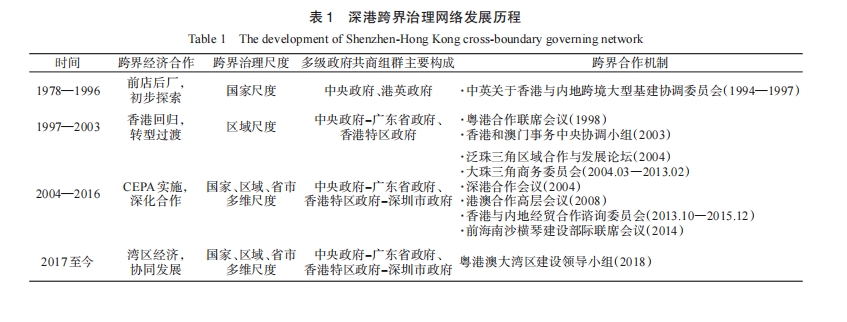
In the context of globalization, cross-boundary regions have become strategic areas for improving national competitiveness and promoting local development. Moreover, cross-boundary governance has gradually become a key issue in regional integration research. Recently, with the increasing trend of anti-globalization, exploring regional governance transformation is crucial for national development. This article conceptualizes a research framework that is a cross-boundary governing network based on policy network theory. It is believed that in cross-boundary governance, various state actors based on common development goals form multi-level and systematic state communities under the restructuring of state capacity while working together to promote cross-boundary regional development. Among them, economic territorialization and state capacity are the key to understanding this concept. Furthermore, under the institutional framework of "one country, two systems," an empirical study was conducted using the Shenzhen Hong Kong cross-boundary region as an example, highlighting the close relationship between the process of economic territorialization and the construction of the cross-boundary governing network. This study explored the operational methods of cross-boundary governing network, and further analyzed the impact of state-society paradigms on the operation of cross-boundary governing network under asymmetric governance. Research has proven that the cross-boundary governing network is a resilient governance mechanism for understanding the process of government-led institutional integration in cross-boundary areas. The new framework also contributes to the policy network as follows: First, the new conceptual framework is more likely to be understood as a complex, multi-type mixed network that is used to overcome the problem of the limited applicability and oversimplification of ideal policy network typologies in practice. It helps to understand the connection between the state-led decision-making process and the state-society interaction process. Second, it is configured on a logical need to contextualize the policy network to the broader and everchanging meso-level territorial scales within which state actors are defined and located within different state-society relations. Third, the factors of "resource" and "power," which are the functional core of the policy network, have yet to be fully defined with little consensus. The "new" will be centered on the configuration and realization of the state capacity of involved state actors as the bridging role of both meso-level networks. Furthermore, the "general-purpose" and "task-specific" components inherent in the multilevel governance approach are adopted to describe different systematic state communities. Meanwhile, the inter-actor idea of an "advocacy coalition" is also incorporated to understand the consensus-forming process within the intra-territorial network. Under the dynamic construction of the cross-boundary governing network, this multi-level and systematic governance approach will continuously deepen the development of Shenzhen Hong Kong cross-boundary cooperation, to make a theoretical contribution to cross-boundary synergistic development in other regions.
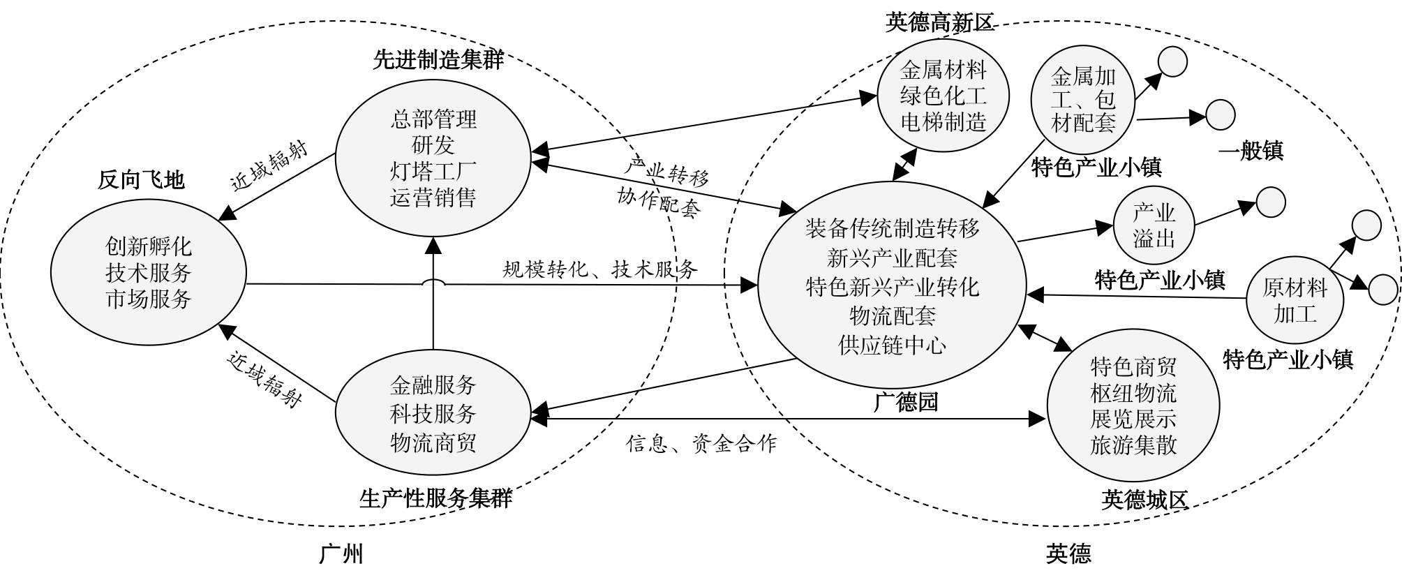
The "enclave economy" is an important governance tool for promoting regional integration. Guangdong Province occupies the leading position in exploring the "enclave economy" model in China, which has effectively promoted the development of the east and northwest of Guangdong Province through the "point to area" approach. However, certain problems that are associated with the "enclave economy" concept, including a weak level of industrial relatedness, disconnection with the development of the local urban system, and inadequate interest driving mechanisms, need to be urgently addressed. The article aims to explore the high-quality development path of the "enclave economy" in the new era, taking advantage of the symbiosis theory. Based on field research and semi-structured interview methods, the present study attempts to not only probe into the cooperative relationship and mutually beneficial symbiosis mechanism among different actors in the "enclave economy" but also explore a more sustainable and mutually beneficial development "enclave economy" model. With respect to theoretical contribution, based on the symbiosis theory and the characteristics of the "enclave economy", this study facilitates a better understanding of the high-quality development logic of the "enclave economy" from the perspective of symbiosis in particular and establishes a theoretical framework comprising the "industrial symbiosis network-industrial symbiosis unit-interest symbiosis mechanism" components. Empirically, this study takes the Guangqing Economic Cooperation Zone (Guangde Park) as the case study; reveals the development process and problems of the "enclave economy", including the isolation of industry transplantation, fragmentation of industry-city units, and locking of interests and mismatch between rights and responsibilities; and proposes high-quality development strategies, such as establishing a cross-regional "enclave economic circle", a resource-linking platform between industry and city, and a community of interests in industrial parks and towns, to form a more sustainable symmetric and mutually beneficial symbiotic mechanism. The key contribution of this study lies in the theoretical framework for the high-quality development of the "enclave economy" through the lens of symbiosis, which enriches the ways of analysis and cognitive logic of the "enclave economy" and advances cross-regional cooperation and "enclave economy" research. It enhances the cross-territorial geographic thinking of regional cooperation and "enclave economy" research, holding the potential to provide decision-making references for the promotion of regional coordinated development in Guangdong Province in the new period. It also has practical application value for relieving the pressure of unbalanced and insufficient regional development in China by promoting cross-municipal and cross-provincial cooperation.
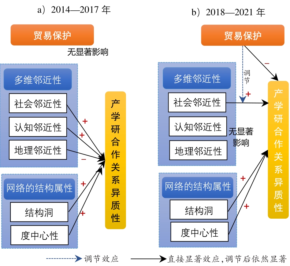
The international non-tariff trade protection against China has gradually increased since 2018, hindering technology trade. Under the impact of the new trade protection, we still know little about how the electronic communication industry (as one of the strategic high-tech industries)changes the innovation cooperation relationship and the innovation performance. Owing to the failure of geographical research to integrate trade protection into the existing research framework from an institutional perspective, the trade protection literature and the innovation geography literature do not intersect. However, the trade geography literature has not paid enough attention to the evolution of industrial innovation in China in recent years and has not taken into account the heterogeneity of the industry-college-institute cooperation and innovation relationship and its impact on regional industrial innovation performance. Based on the 2014-2021 US Export Control Regulations and the invention patent data of the electronic communication industry in the Pearl River Delta, this study uses descriptive statistics, a Quadratic Assignment Procedure, and a negative binomial regression model. It explores both the mechanism and effect of a new round of trade protection on industry-college-institute cooperation and their joint impact on cooperative innovation performance. The study finds that the structure of the industry-college-institute cooperative innovation relationship in the electronic communication industry of the Pearl River Delta has gradually decentralized, and its heterogeneity growth tends to stall. The new round of trade protection significantly regulates geographical proximity, deteriorating the geographical scale of cooperative innovation. The regression results show that under the impact of trade protection, the heterogeneity of industry-college-institute cooperation changes from positive to negative, and the inverted U-shaped relationship has reached a significant level. Trade protection changes the influence of social and cognitive proximities and of geographical proximity on cooperative innovation performance, and the moderating effect of trade protection is highlighted by the positive effect of strengthening geographical proximity on industry-college-institute cooperation and innovation performance. The above findings remind us of the need to further refine and optimize innovation support policies. Therefore, the study puts forward some targeted policy suggestions, namely, to formulate innovation support policies suitable for the internal and externalized innovation transaction costs of different types of enterprises, strengthen the dominant role of enterprises in innovation, and promote cross-regional cooperation. To a certain extent, it can inform the decision-making by China's regional strategic industries around ending the international technology trade blockade and achieving high-quality independent innovation and technical cooperation.
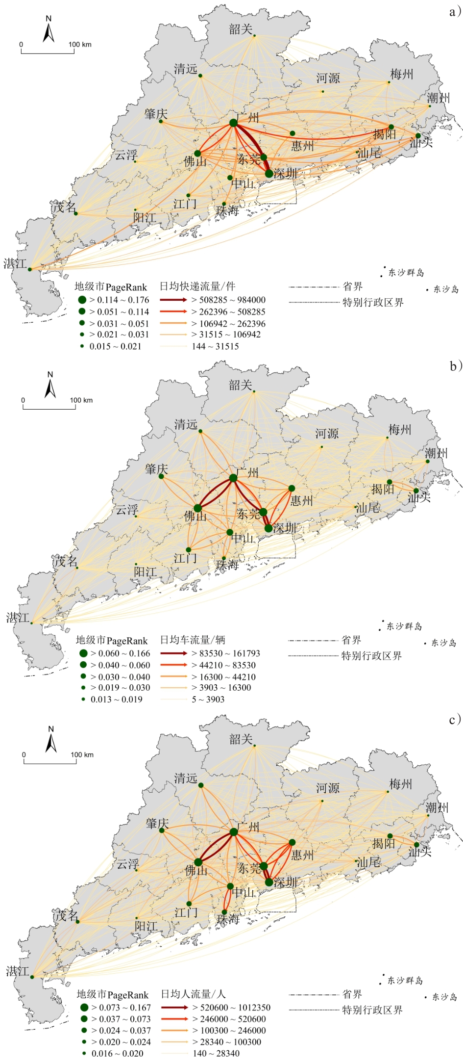
Understanding the framework of regional urban economic organization and its spatial effect requires a consideration of the networks. Urban network research has increasingly focused on urban spatial interaction and economic spillover effect based on the network externality theory in the context of transition from network research on structural description to performance evaluation. This study focused on Guangdong Province as the research area, built intercity passenger and freight flow networks based on the traffic, people, and express flow, studied the spatial structure of the network using social network analysis and other quantitative methods, and used a spatial Durbin model to estimate the economic spillover effect of the network. The conclusions from the results obtained can be summarized as follows. (1) In the network of traffic and people flow, Guangzhou and Foshan occupy the central positions. The core node of the express flow network spans Guangzhou, Dongguan, and Shenzhen. The spatial distribution of core linkages in the people flow network could be summarized as "the double-channel mode" of Guangzhou-Foshan and Shenzhen-Dongguan, while the corridor distribution of Foshan-Guangzhou-Dongguan-Shenzhen is the dominant flow organization pattern in the traffic flow network. In the express flow network, the dominant flow is dispersed eastward along the coast. (2) Guangzhou serves as the primary controlling entity of the network. Urban nodes clearly differ functionally in the express flow network; however, there is little functional difference in the traffic and people flow networks. (3) According to the spatial regression coefficients based on the SDM of the traffic, people, and the express flow networks, which are -0.974, -1.255, and -8.173, respectively, the economic externality of intercity passenger and freight flow networks reveal a substantial negative spillover. The current growth trend of Guangdong Province is not coordinated or complementary. (4) Coordinated expansion of the regional economy has been facilitated by improved functional connections between urban nodes. In addition, The movement of intercity factors could lower consumer market transaction costs and entrance barriers while allowing regional cities to enjoy the development advantages of borrowed size. However, the improvement of the conditions supporting the business infrastructure has expedited resource siphoning and intensified the province space's agglomeration shadow. This study created urban networks based on the movements of the passenger and freight flows, thereby enriching the empirical investigation of the externality theory in South China. This study also provides some guidance for advancing the regional economic integration and high-quality development.
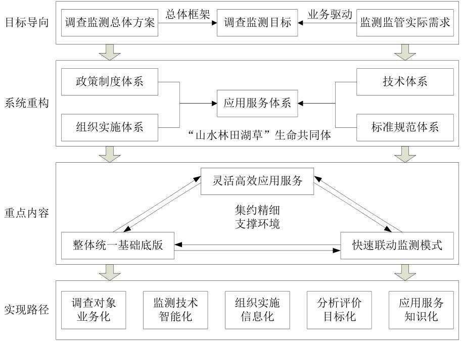
Provincial-level natural resources survey and monitoring play a crucial role in the national natural resources survey and monitoring system. Constructing a provincial-level system is essential for effectively implementing the national survey and monitoring work. However, the construction of such a system in Guangdong Province, a typical tropical and subtropical coastal region with diverse natural resources and distinctive geographical characteristics, presents significant challenges. This study focuses on addressing several problems encountered in Guangdong Province, including the lack of optical image data due to the region's cloudy and rainy climate, fragmented monitoring patches resulting from complex terrain and landforms, rapid changes in the surface caused by high-intensity human activities, and the difficulty in managing a wide range of monitoring objects. By clarifying the goals of natural resources survey and monitoring, this study systematically reviews the status and practical needs of a provincial-level survey and monitoring work and summarizes the key issues in the construction of the survey and monitoring system. This study proposes an overall construction plan for a provincial-level system that includes establishing a unified basic platform, which aids in implementing a fast and coordinated monitoring mode, developing flexible and efficient application services, and strengthening intensive and refined support environments. It also analyzes critical challenges, such as organizational model restructuring, accurate object recognition, and technological integration. Finally, this study presents a path to achieve the provincial-level natural resources survey and monitoring, focusing on object-based businesses, information implementation, technological intelligence, targeted evaluation, and service knowledge. Regarding investigation targets, this study emphasizes adopting a "business-oriented" approach, enhancing the alignment of investigation and monitoring with precise business strategies and facilitating bidirectional feedback. Regarding organizational implementation, this study emphasizes strengthening support through "information technology," establishing provincial-level coordination and a municipal and county-level division of labor model, commonly referred to as the "general-subordinate-general" organizational structure. Regarding monitoring technology, this study emphasizes adopting an "intelligence-led" approach; it is primarily centering on pivotal technological research related to collaborative perception, intelligent processing, integrated management, and intelligent services. Regarding analysis and evaluation, this study emphasizes a "target-oriented" approach, centered around supporting economic and social development and optimizing natural resource management through comprehensive analysis and evaluation. Regarding application services, this study emphasizes delivering "knowledge-based" services and exploring the development of a model that encompasses the knowledge ontology of natural resource investigation and monitoring. This study promotes the orderly construction of a survey and monitoring system in Guangdong Province, provides a scientific basis for provincial-level natural resource surveys and monitoring work and serves as a reference for the construction of survey and monitoring systems in other regions.
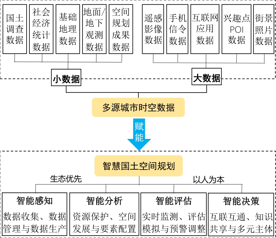
In recent years, the state has promulgated a series of policies aimed at establishing a national territorial spatial planning system and advocating for the creation of an integrated "multi-regulation in one" system. The issuance of these policies marked the formal commencement of constructing the territorial spatial planning system. Territorial space is a type of environment, and the description of its functions essentially elucidates the relationship between humans and land. This relationship represents a complex interplay of static and dynamic interactions among elements such as stakeholders, the environment, and activities within a defined spatiotemporal framework of the system. In the new era, territorial spatial planning is required to perceive, analyze, evaluate, and decide upon various resource elements and the spatiotemporal information of diverse activities of people within a national territory. Multi-source urban spatiotemporal data empowers the intelligent processes of perception, analysis, evaluation, and decision-making regarding these resources and activities, propelling the evolution from traditional to smart territorial spatial planning. This study aimed to construct a comprehensive framework for smart territorial spatial planning and multi-source urban spatiotemporal data application to promote the modernization of the territorial governance system and its capabilities. This was done by adhering to the fundamental principles of "ecological priority" and "human-centricity." Taking Guangzhou as an example, this study investigated how multi-source urban spatiotemporal data empowers the drafting, approval, and supervisory execution of smart territorial spatial planning. Multi-source urban spatiotemporal data support territorial spatial planning in four dimensions: sustainable development, high-quality growth, high-quality living, and high-level governance. For sustainable development, spatiotemporal data obtained from land surveys, ground/subterranean observations, and spatial planning outcomes, bolster the assessment of land resource carrying capacity and suitability evaluation for territorial development. This approach fosters optimized layouts for ecological, agricultural, and urban spaces and propel the construction of beautiful territorial spaces. Regarding high-quality growth, spatiotemporal data provide a robust foundation for data support and decision-making in national territorial space governance. In urban villages, multi-source data aid in enhancing the quality of high-density mixed-use spaces. In wholesale markets, data analyses assist in the optimal allocation of spatial resources, promoting orderly governance. In village-level industrial parks, spatiotemporal data underpin classified policymaking, refining industrial layouts. In terms of high-quality living, multi-source urban spatiotemporal data support the construction of diverse human-centric cities by precisely quantifying the level of street greening and estimating the demand for various public services. Regarding high-level governance, multi-source data facilitate the monitoring, assessment, and early warning of territorial space resources as well as the scientific adjustment and decision-making of related management measures. This data-driven planning approach provides scientific decision-making support for high-level urban governance, marking a transition toward more intelligent and refined territorial spatial planning. However, practicing smart territorial spatial planning in Guangzhou not only validates the empowering role of multi-source urban spatiotemporal data but also exposes the challenges in its application. The acquisition of multi-source urban spatiotemporal data is difficult and costly, and the absence of unified application guidelines presents challenges in data acquisition and comparison of analytical results. Consequently, the future research on smart territorial spatial planning should focus on establishing standardized data channels and application norms, enhancing the multi-source data integration and the construction of a "one map" platform, and fully incorporating interdisciplinary theories and technologies.
City regions, as the most significant geographical consequence of globalization, have received constant attention by economic geographers. However, although mainstream theories such as the Global Production Network (GPN) theory explain the emergence of global urban areas well, there remains a lack of strong explanation for the obvious functional heterogeneity phenomenon of major cities within the Guangdong Hong Kong Macao Greater Bay Area (GBA). This study draws on the structuralist thinking method and introduces the perspective of civilization interaction, examining the historical reasons for the functional differentiation of core cities in different historical periods dominated by trade and production networks to explore the mechanism of forming a unique spatial order within the GBA. From the macro perspective of the formation of the world system and the transfer of China's basic economic zone, this study highlights that the development history of the GBA reflects the history of continuous interaction between continental and marine civilizations, which is finally embedded in the world system. Based on the evolution of the major city relations in the GBA, this study investigates the core-city relations across different periods—from the classical trade network era to the global production network era—and analyzes the formation mechanism of core-city relations in different periods. By analyzing the changes in the way civilizations interact in the era of innovation, the study looks forward to the direction of future spatial paradigm transformation in the GBA and posits that the Inner Bay Area may play a leading role. By expanding the dimension of historical observation, the study enriches the perspective of research on the global city regions and the GBA by combining the civilization interaction and the structuralist transformation characteristics with the analysis of the internal order of urban areas. Owing to the continuity and comparability of the interaction of civilizations, this study is able to apply the conclusions of the analysis of the relationships and spatial order of major cities across past historical stages to the new stage dominated by innovation for the future, as well as providing theoretical assistance for the analysis of regional development trends and formulating response plans.
Optimizing the ecological network structure and enhancing habitat connectivity are key to ensuring urban ecological security, and the combination of urban big data can more accurately reveal the stress effects of the spatial heterogeneity of human activities on ecological connectivity. In recent years, numerous studies have focused on urban ecological networks; however, they have been limited by the accuracy of correction resistance data and the lack of source corridor identification methods, which makes it challenging to establish ecological networks with attributes. Thus, small- and medium-sized urban ecological network construction and connectivity stress analysis are lacking. In this study, a comprehensive resistance surface was constructed based on Point of Interest(POI) data and land use data; an ecological network with quantitative attributes was constructed using the InVEST habitat quality analysis and circuit theory, and the stress factors and disturbance intensity affecting the corridor connectivity of the network were clarified. Three main conclusions were drawn from the above analysis. First, the overall habitat quality of Nansha New District is good, and the centrality of ecological source areas ranges from 26.8 to 69.26. This centrality is inversely correlated with the source area's weighted center of gravity distance and positively correlated with the source area. The connectivity of most ecological corridors is between 17.56 and 92.56 and is inversely proportional to the corridors' length and resistance. Second, the ecological network of Nansha New District consists of 18 high habitat quality sources, 40 optimal ecological corridors, and 125.70 km2 of potential corridors, spatially showing an introverted spatial pattern of "dense in the middle and sparse in the north and south." The corridors in the middle are more densely distributed and shorter in length and have higher connectivity and a concentrated distribution of sources. The north and south ends are scattered with low-level sources and the formation of more long-distance corridors with low connectivity. Finally, the main threatening factors of corridor connectivity in Nansha New District are four types of POI facilities, namely, companies, transportation facilities, shopping consumption, and life services. The numbers of corridors mainly coerced by companies, transportation facilities, life services, and shopping consumption POI are 23, 10, 5, and 2, respectively. Reducing and controlling the number of the above four types of POIs in the latent corridors will effectively enhance the connectivity of ecological networks and alleviate the isolation of source areas, reducing the trend of source islanding and habitat fragmentation. The research results can provide a concrete entry point for the maintenance of an excellent ecological background in Nansha New District in terms of spatial scope and facility renovation, which is of practical significance for the construction of a high-quality urban development benchmark.
The study of everyday life has gained attention across various disciplines in the context of modernity. This study utilizes Lefebvre's rhythmanalysis to explore the everyday experiences of residents in the Xiguan Community, a historically significant residential area in western Guangzhou undergoing urbanization and tourism development. Adopting an emic perspective, this study employed auto-ethnography to depict the daily rhythms and spatially embodied experiences of the author, a native resident of the Xiguan Community. By incorporating reflective and self-narrative elements and comparing them across generations, this approach provides first-hand knowledge and self-awareness. This research offers an insider's comprehensive understanding of the effects of urbanization and tourism on residents' everyday lives. Informed by Lefebvre's rhythmanalysis, this analysis incorporates spatial and temporal dimensions, with a specific emphasis on residents' experiences of spatial embodiment and their engagement with everyday rhythms. The study reveals two key findings: First, urbanization and the commodification of landscapes have created a constructed "the present" in traditional communities, displacing the meaningful "existence" of everyday life. Certain spaces within these communities have detached from residents' everyday lives, serving urban and tourism purposes, and leading to partial alienation in spatial and temporal dimensions. These spaces represent the simulacra and fragments of residents' everyday lives, lacking subjectivity, temporality, and wholeness. Over time, the "existence" that embodies the meaning of residents' everyday lives has been squeezed out by structural forces such as urban renewal and community tourism. For tourists, these landscapes may serve only as replicas of attractions, devoid of the essence of residents' everyday lives. For the residents, these community spaces have become manifestations of instrumental rationality and commodification. Second, this study highlights that traditional community residents' bodies are disciplined and governed by the instrumental rationality of urban production and the invisible rhythms of the tourism industry. In large cities, the significance of individual bodies in traditional urban communities is often overlooked, as bodies become tools for creating value through work. Individuals adjust their everyday rhythms based on urban settings' production rationality and efficiency priorities. This undermines the bodily rhythms that align with natural cycles and prompts residents to distance themselves from traditional communities. While the older generation in the Xiguan Community experiences overlapping leisure time and shares community spaces, fostering solid social relationships, the younger generation faces longer working hours, extended commuting distances, and more individualized leisure time. As a result, there is a lack of synchronization in leisure rhythms among neighbors. The embodied rhythms of traditional community residents have shifted from a state of harmony with natural rhythms and community spaces to being governed by the instrumental rationality of urban production and invisible rhythms of the tourism industry. This study provides an emic and longitudinal perspective to the investigation of spatial experiences and embodied rhythms in urban and tourism development. The use of auto-ethnography amplifies residents' voices and calls for greater consideration of local daily life. These findings emphasize the importance of incorporating residents' everyday experiences into the planning and development of sustainable communities and tourism.
Accessibility is one of the effective methods to measure whether the spatial layout of public service facilities is effective. However, traditional accessibility research often ignores urban dynamics and the issues with overall accessibility when there are multiple types of facilities. This study focused on Hefei and used dynamic data from sources such as transportation, ambulances, and stroke centers to build a dynamic stroke emergency network integrating the services of "the community, emergency medical center, ambulance, and stroke center." Baidu's map API (Application Programming Interface) was used to estimate the dynamic traffic cost at six important moments of one day. Lorentz curve and Gini coefficient were used to measure the spatial equity of overall accessibility. A systematic analysis was performed to evaluate the changes in dynamic accessibility and spatial equity at different times of a day. The results reveal the following. (1) The overall accessibility in Hefei has reached the golden "1-hour" service standard. More than 75% of the communities had a travel time of less than 30 minutes. However, excessive emergency resources are concentrated in the city center; this is ill-matched to the development and population needs. The communities with travel times more than 60 minutes were mainly distributed in the northern part of the Hefei Economic and Technological Development Area and the west side of Shushan Area. These areas are remote, with inconvenient transportation and are very far from emergency centers and stroke hospitals. (2) The accessibility of the emergency network fluctuates greatly with time, and the accessibility during the morning and evening peak periods are mainly affected by traffic flow. Compared to the peak period, the accessibility fluctuation during the off-peak period is generally smaller. However, the dynamic adjustment of ambulance resources in the day and evening shift in Hefei did not have a huge impact on the accessibility of the overall emergency network. (3) The overall accessibility of the stroke emergency network in Hefei is poorly balanced. The two times of the day with the best and worst overall spatial layout are at 8:00 and 22:00, respectively. In the study of time-sensitive accessibility to first-aid during a stroke, the results of the proposed high-precision first-aid network model and the time-varying accessibility estimation method are more accurate and reliable. Baidu map API is suitable for the computation of the origin to destination travel costs when using road networks. Therefore, to improve the precision and effectiveness of the accessibility estimation results, while studying the accessibility of first-aid for stroke in urban areas, it is necessary to consider the influence of dynamic factors such as traffic flow and the opening time of facilities and the overall accessibility of the service system which comprises multiple types of facilities.
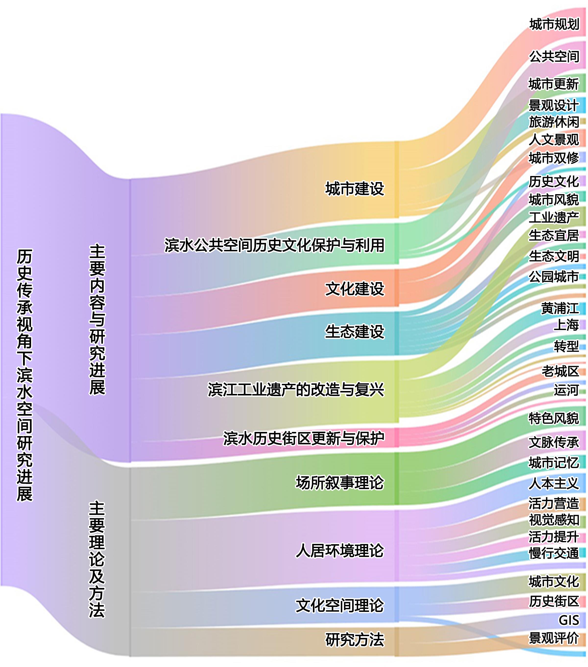
Urban waterfront space has important practical significance for inheriting and developing urban cultural characteristics, promoting the driving role of culture in urban development, and creating regional cultural artistic conceptions. This study comprehensively uses the methods of bibliometric visual knowledge map analysis and a qualitative reading of literature, systematically combing through the relevant research literature with the help of quantitative analysis and a qualitative perception of the literature analysis system. Through this approach, this study summarizes the stage characteristics, theoretical basis, and implications of waterfront space research from the perspective of historical inheritance. The research methods, research content, and hotspots clarified the research context of waterfront space from the perspective of historical inheritance. Based on bibliometric analysis, it is evident that research on the historical inheritance to waterfront space is primarily driven by universities and spans disciplines such as human habitat science, ecology, geography, urban planning, and architecture. Human settlement environment theory, cultural space theory, and place narrative theory together constitute the theoretical framework of the research on the historical inheritance of waterfront space. Domestic research on the historical inheritance to waterfront space in China primarily relies on traditional qualitative methods, while quantitative empirical methods have yet to become mainstream. In general, the research concerning the historical inheritance of waterfront space can be divided into three stages: first, a phase focused on the development and construction of waterfront spaces oriented towards recreation, commerce, and tourism functions; second, a stage of transforming and renewing waterfront spaces by leveraging urban development processes; and third, a stage aimed at preserving the unique cultural heritage of cities through the historical continuity of waterfront spaces. The transformation and revival of waterfront industrial heritage, the renewal and protection of waterfront historic blocks, and the protection and utilization of historical waterfront public space culture have become hot topics in the current research on the historical inheritance of waterfront space in China. This study concludes that the existing research is faced with problems such as unbalanced research areas, insufficient empirical research, and a serious separation of "pleasure" and the "ideal". Future research should focus on the system of waterfront space research as it deeply enriches the research methods, improves the research system, and provides direction and support for the historical inheritance and protection of research of China's waterfront space.
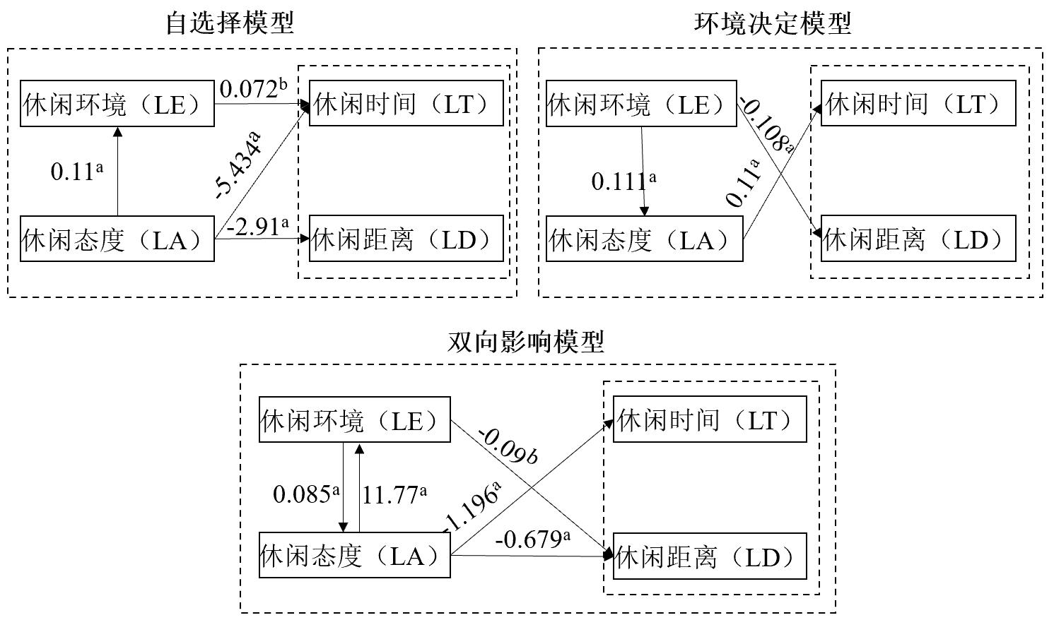
Leisure plays an important role in people's happiness; therefore, facilitating participation in leisure activities has become one of the pathways to improve urban residents' wellbeing and realize high-quality new urbanization. This study focuses on migrant workers' leisure behavior and quality of life. Based on the self-selection hypothesis and structural equation modeling analysis, this study explores the influence of both leisure environment and leisure attitude on leisure behavior. First, our analysis of the leisure environment revealed that leisure behaviors differed according to leisure environments. Residents of resource-rich communities had the longest leisure time, a medium leisure distance, and a positive leisure attitude. Communities with medium leisure resources had the shortest leisure time and closest leisure distance. Communities with scarce leisure resources had the longest leisure distance and the most negative leisure attitude. Second, by examing the match of leisure attitudes and leisure environments, we found that the average leisure time of matching groups was longer, and they generally spent their leisure time within 1 kilometer around the community. Furthermore, the leisure time of residents in communities with scarce leisure resources did not show significant differences. For the mismatching groups of leisure attitudes and environments, about 60% of the residents spent less than 2 hours on average per day, and the leisure distance did not show any significant difference. Third, the structural equation modeling analysis indicated that both attitude and environmental attributes can affect migrant workers' leisure behavior; they further interact with each other and jointly determine residents' leisure behavior. The temporal (leisure time) and spatial (leisure distance) dimensions of leisure behavior are influenced by different mechanisms. Leisure attitude has the most direct effect on leisure time, while the effects of leisure environment on leisure distance are complex. Socio-demographic attributes affect leisure environment, leisure attitude, and leisure behavior. Men and women do not differ in terms of leisure time, but women's leisure distance is greater than men's. Age has no significant effect on residents' leisure behavior, but younger persons enjoy more leisure. Monthly household income has a significantly negative effect on residents' leisure time and leisure distance, while it has a significantly positive effect on leisure environment. Persons with higher education pay more attention to their leisure life, and spend more time and travel to participate in more leisure activities. This study makes three contributions. First, in the context of leisure scenarios, it promotes the combination of self-selection effect and rational behavior theory, and fully considers the role played by attitude in the mechanism of environmental influence on behavior. Existing studies of transportation mostly follow functionalism in the pursuit of efficiency, and the scope and ability of residents' self-selection is limited. This study of leisure behavior empirically demonstrates the importance of leisure environment and leisure concepts cultivation. Second, the study of migrant workers' leisure provides inspiration for the construction of new urbanization. In China's rapid urbanization, migrant workers have made positive contributions to the development of cities at the sacrifice of their youth and health. The leisure self-selection effect can be used to improve residents' leisure participation and subjective well-being by enhancing the community's leisure environment. Third, the migrant worker group is diversifying. With the deepening of new urbanization, their daily lives are changing and they are making continual efforts to adapt to urban life, rather than remaining passive.
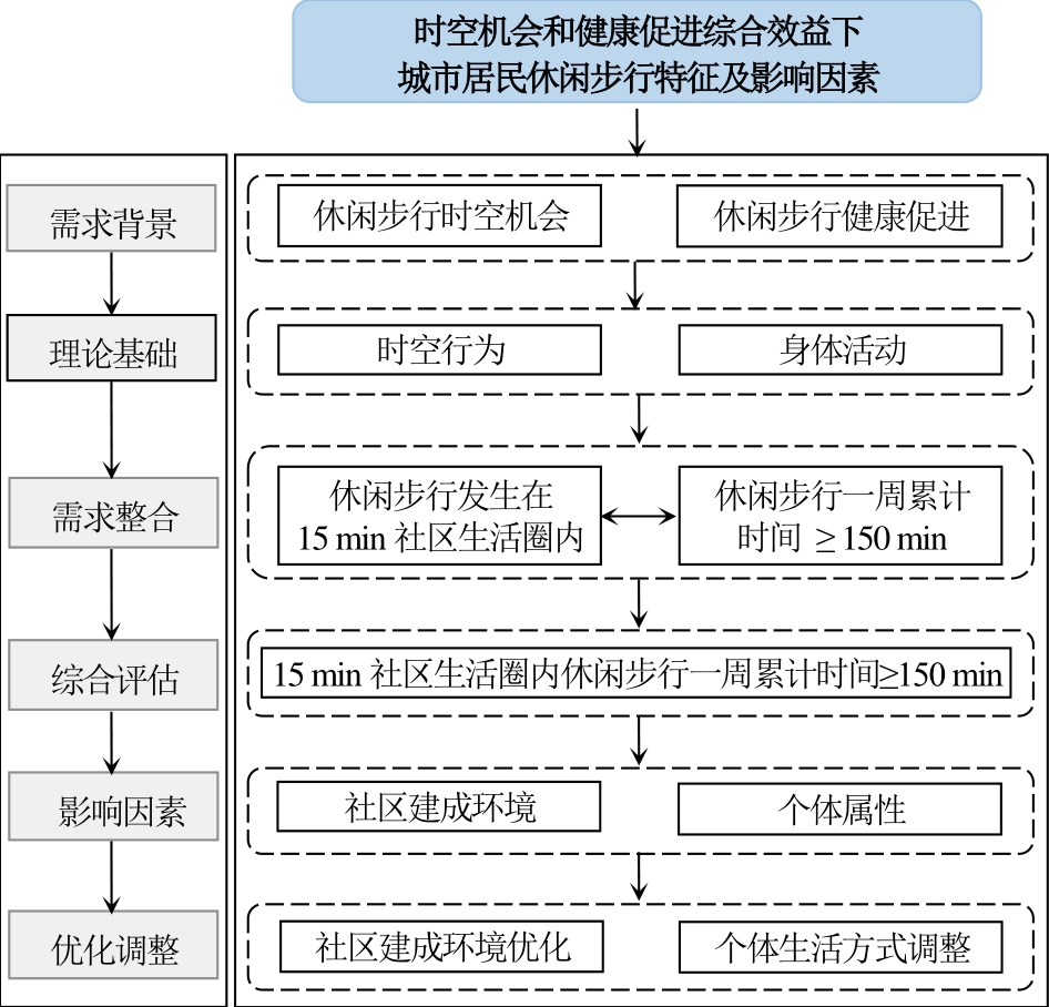
At present, the continuous improvement of urban residents' quality of life puts forward higher requirements for exploring the supply and demand of leisure walking. Against this background, this study focuses on leisure walking, taking the 15-minute community life circle as the space-time scope to re-examine the cumulative health effect of leisure walking as physical activity. Additionally, this study constructs a research framework to highlight the comprehensive benefits of leisure walking, including space-time opportunity and health promotion. Based on the research framework, this study uses comprehensive survey data from relevant communities in Nanjing to conduct an empirical study on the characteristics and influencing factors of leisure walking. The results show that the leisure walking of most residents makes it difficult to obtain comprehensive benefits, including space-time opportunity and health promotion. The built environment of the 15-minute community life circle significantly affects leisure walking based on the comprehensive benefits of space-time opportunity and health promotion. Specifically, the dense distribution of walkable paths has a promoting effect on overall residents and residents based on age and income stratification. In contrast, high-density population distribution and living locations far from the city center have an inhibitory effect. In addition, dense parks, high green coverage, and good public space accessibility positively affect stratified residents. The influence of individual attributes involves three aspects: socioeconomic attributes, health status, and family socioeconomic attributes. Specifically, overall or stratified residents with flexible and abundant leisure time and family members' accompanying behavior are more likely to participate in leisure walking and obtain more health benefits in a shorter space-time range. However, affected by the limited leisure time and poor physical condition, overall or stratified residents with a higher level of personal monthly income, families with children (<18 years old) who need to be cared for, and sub-health symptoms have fewer opportunities to walk leisurely within the 15-minute community life circle and obtain fewer health benefits. Therefore, space optimization that considers the comprehensive benefits of space-time opportunity and health promotion should cover all residents to the greatest extent possible and strengthen the overall planning, connection, and enrichment of leisure walking resource allocation inside and outside the life circle. The differences between this study and previous ones include two aspects. Taking high-density and highly mobile cities in China as case studies, first, at the community level, this study combines the perspectives of space-time behavior and health, comprehensively measures the space-time opportunity and health promotion effects of leisure walking, and integrates the comprehensive value of leisure walking into urban social spaces. Second, when examining the comprehensive impact of the community built environment on leisure walking space-time opportunity and health promotion, it combines objective and subjective perceptions to more realistically evaluate the residents' activity environment.
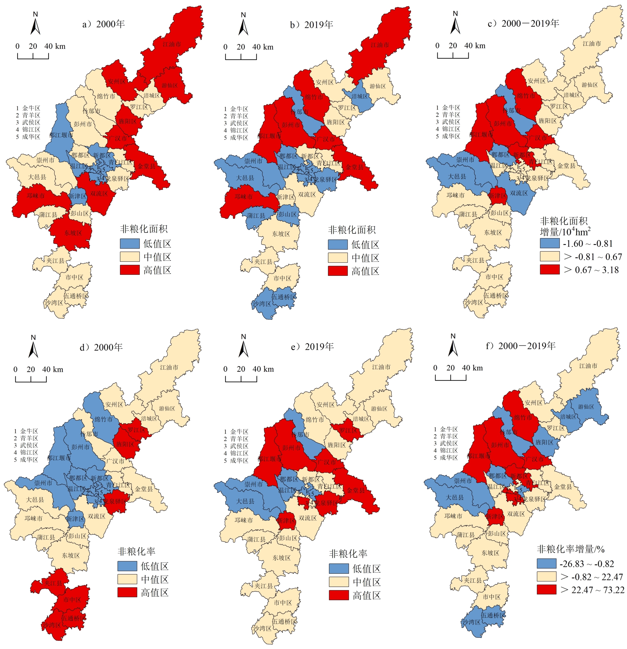
Cultivated land is the cornerstone of grain production and the basic resource to ensure food security. Understanding the non-grain production status of cultivated land in the main grain-producing areas of western China is necessary to provide a basis for regional sustainable agricultural development and cultivated land protection decision-making. In this study, Chengdu Plain was selected as an empirical research area. A mathematical quantization model and spatial autocorrelation method were used to analyze the spatiotemporal characteristics of non-grain production of cultivated land in Chengdu Plain, and an econometric model was constructed to identify its driving factors. The results showed that the cultivated land area did not change significantly in the Chengdu Plain from 2000 to 2019; however, the small change in cultivated land area did not mean that its actual use changed little, and the non-grain production status of cultivated land was obvious. (1) From 2000 to 2019, both the Non-Grain production Area (NGA) and the Non-Grain production Rate (NGR) in Chengdu Plain showed a fluctuating and increasing trend, with an increased rate of 4.40% and 13.53%, respectively, which indicates that cultivated land protection and food security were under great pressure. (2) In terms of space, the NGA in 34 districts and counties of Chengdu Plain presents a multi-center scattered distribution, which shows a spatial pattern of high in the center and low in the northeast and southwest, and the NGA's spatial agglomeration areas are concentrated in Chengdu and its neighboring cities. (3) Economic Crop Planting Scale (ECPS), Agricultural Structure Adjustment (ASA), Urbanization Rate (UR), and Cultivated Land Protection Policy (CLPP) are the most important factors affecting the non-grain transformation of cultivated land in Chengdu Plain. Some suggestions are proposed: red lines should be drawn to implement a control system for cultivated land use; departmental collaboration must be strengthened to build a synergy of cultivated land protection; the agricultural subsidy system must be improved to defend farmers' fundamental rights and interests; and policy advocacy for cultivated land protection should be enhanced to raise food security awareness. This study can better reflect the non-grain production status of cultivated land in Chengdu Plain, and from the spatial unit of district and county, it provides a good perspective for the study of the non-grain production of cultivated land. This study also provides a scientific foundation for decision-making regarding regional sustainable agricultural development and cultivated land protection.
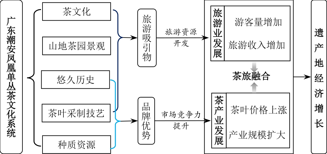
Agricultural Heritage Systems (AHS) have high economic value. In addition, their protection and management focus on the dynamic conservation and sustainable development of heritage sites, which play an important role in the economic development of such sites and have attracted the attention of many scholars. However, the economic effects of AHS recognition on heritage sites have not been well described in previous research. Therefore, taking the Phoenix Oolong tea culture system in Chao'an, Guangdong Province, as an example and selecting Chao'an District and Raoping County as research areas, this study attempts to explore the contribution of AHS identification to the economic growth of heritage sites. First, it collected economic data on the heritage site (Chao'an District) and control area (Raoping County) from 2010 to 2019. From the perspective of total volume change and industrial development, this study compared the difference in economic growth between heritage sites and control areas after China's Nationally Important Agricultural Heritage Systems (China-NIAHS) were recognized. Subsequently, using interrupted time series analysis, this study quantitatively analyzed the significance of the changing trend of economic growth and industrial development difference between the two areas after this recognition. Based on these results, combined with a field investigation, this study discusses the specific path of AHS identification that affects heritage sites' economic growth. The results show that after the identification of the Phoenix Oolong tea agricultural system in Guangdong Province, the tourism and tea industry in Chao'an District developed rapidly, and tourism income increased significantly, which is conducive to local economic growth. Specifically, after the identification of the Phoenix Oolong tea culture system in Chao'an, Guangdong Province, the economic aggregates of Chao'an District increased. Among them, tea area, production, output value, number of tea cooperatives, and enterprises in Chao'an District all increased, and the tourism income and number of tourists received increased yearly. However, compared to Raoping County, the growth in tourism income in Chao'an District was the most significant. This study also found that heritage recognition inhibited the growth of tea cooperatives in the Chao'an District. Further analysis shows that the recognition of China-NIAHS effectively promotes the resource exploitation of heritage tourism, enhances the brand advantage of Phoenix Oolong tea, facilitates the development of the tourism and tea industries in Chao'an District, and integrates tea tourism in the heritage site, thus promoting the site's economic growth. At the same time, these economic achievements were also made possible by sound policy support. Therefore, the governments of heritage areas should attach importance to the role of agricultural heritage in regional development and give full play to the economic driving role of AHS. In conclusion, this study enriches relevant studies on AHS to a certain extent and provides empirical research ideas for the economic growth analysis of AHS as well as effective paths for its economic development.
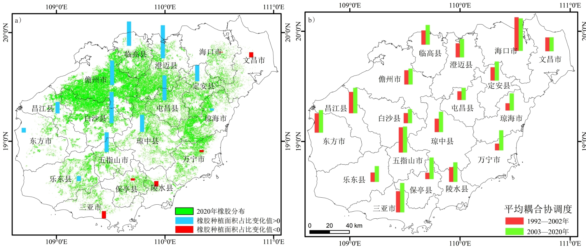
Population urbanization is the core of new urbanization in China and is an important task in the long term. Based on mediation effect models, spatial panel data econometric models, and coupling coordination models, this study attempts to identify the direct and indirect effects of the proportion of rubber-planted areas and the indications of population urbanization using panel data of counties on Hainan Island, explaining the mechanism. The results show that rubber plantations dominated by state-owned farms weakly impacted farmers' income in 1992-2002 (first phrase), and the effects became positive in the period of smallholding expansions from 2003 to 2013 (second phrase) at a statistically significant level of 10%. However, the effects became negative between 2013 and 2020 (third phrase) due to the continuously low prices of natural rubber compared to the second phrase; the regions with higher share of rubber plantations had less local fiscal revenues per capita—especially in the third phrase—mainly because of the short industrial chain of rubber in producing regions. Shares of rubber-planted areas in the city or county (defined as rubber-planted intensity, RPI) were negatively related to proportions of staff in the non-private sector (SNS) and nonrural employees (NRE) compared to people with jobs and census registered population urbanization rates (PUR). The reversed connections between RPI and NRE became weaker over time; a 10-percentage point increase in PRI might have led to a 10.3-percentage point decrease in NRE in the first phrase, but it reduced to 3.3 percentage points in NRE with no statistical significance in the third phrase. Conversely, the negative correlation of RPI with SNS and PUR became stronger from the first to third phrase; the farmers' income and local fiscal revenue could ease the negative relationships between RPI and SNS or NRE, but they turned to enhance the relation of RPI with PUR in the second and third phrase. The evidence from Moran's I and Geary's c indices proved the existence of obvious spatial correlations in the distribution of natural rubber and farmers' income and indicated that GDP per capita and other variables are also spatially related. The estimated spatial panel data models with adjacent, geographical and economical distance matrices indicated that the direct influences of RPI on SNS, NRE, and PUR were almost negative in all phrases, but the spillover and total effects can be positive in some situations, such as in the second phrase with adjacent and geographical distance matrices of PUR; this means that an increase in rubber-planted areas may promote nonfarm job market of adjacent regions mainly due to rural labor mobility. The coupling coordination degrees between the intensity of rubber planted and population urbanization of Haikou and Sanya reach 0.96 and 0.87, respectively, in the second and third phrases—much higher than those of other regions. Compared to the first phrase, the margin of increases in the degrees of coupling coordination in the second and third phrases are reducing from the east to west in Hainan Island. The key routes to mitigate the negative links are to improve labor productivity and extend the industrial chain of natural rubber along with the nonfarm job creation, and Hainan's population urbanization should consider many other possible angles across the island.