Owing to the development issues of the Guangdong-Hong Kong-Macao Greater Bay Area in the new domestic and international situation, the content, challenges, and paths of innovation and development of the Greater Bay Area are explored from multiple dimensions, including economic, social, cultural, and institutional. The innovation and development of the Greater Bay Area should strengthen technological and industrial innovation capabilities, improve regional resilience to cope with external shocks, increase the mobility of intraregional factors, improve the well-being of the people's livelihood, enhance the capacity of spatial governance, promote integrated urban-rural development, and optimize the regional pattern of ecological security. The conclusion is that considering the innovation and development of the Greater Bay Area from a systemic and interconnected perspective is crucial for seeking innovations in various development fields and promoting coupling and coordination among them. Therefore, the region may acquire the agency that can continuously break through bottlenecks, resolve external shocks, and unlock new paths of development. We call for the strengthening of cross-field and cross-disciplinary collaborative research to contribute the power of geography to the realization of the development goals of the Guangdong-Hong Kong-Macao Greater Bay Area.
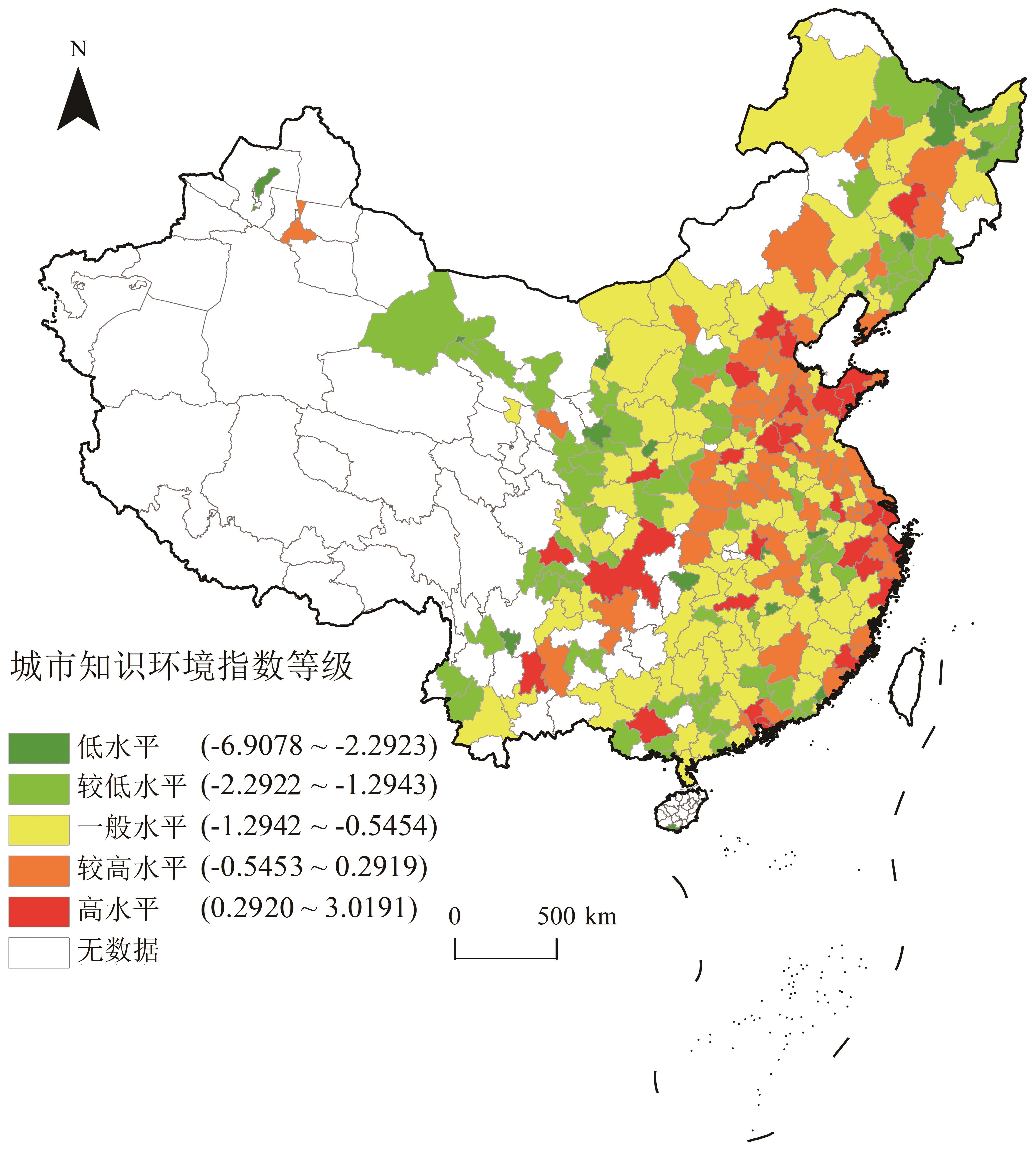
In the era of the knowledge economy, with the increasing role of knowledge and entrepreneurship in cities, the impact of the urban knowledge environment on entrepreneurship has become an important research topic. Cities are the primary carriers of knowledge and entrepreneurship. However, few studies examine the impact of an urban knowledge environment on entrepreneurship. The impact of the urban knowledge environment on entrepreneurship in China remains unclear. Therefore, this study constructs an urban knowledge environment index from the two aspects of urban knowledge stock and knowledge infrastructure, measures the spatial distribution characteristics of the knowledge environment index of 275 cities at the prefecture level and above in China, and analyzes its impact using a spatial regression model. The results show that: (1) The urban knowledge environment index in the eastern coastal areas is relatively high, while that in the central and western areas is relatively low. Cities in major urban agglomerations, such as the Beijing Tianjin Hebei, Shandong Peninsula, Yangtze River Delta, Pearl River Delta, and Chengdu Chongqing urban agglomerations, have a high urban knowledge environment. The level of urban knowledge environment in provincial capitals and above is relatively high, whereas it is relatively low in general, prefecture-level cities. (2) Urban knowledge environments promote entrepreneurship. When other factors are controlled, entrepreneurship increases by 0.239% for every 1% increase in the urban knowledge environment index. (3) Spatial heterogeneity exists in the influence of the urban knowledge environment on entrepreneurship, and its marginal effect differs among cities in different regions and levels. Cities in the east had higher values than those in the central and western regions, and cities at or above the provincial capital level in the same region had higher values than ordinary prefecture-level cities. Among these, the increase in entrepreneurship caused by improving the knowledge environment index of cities at the provincial capital level and above is the largest, nearly three times higher than that of the eastern, central, western, and general cities. This study provides a theoretical basis and practical reference for the development of urban entrepreneurship in China in the new era by revealing the internal laws and impact mechanisms of the urban knowledge environment.
In the era of knowledge economy, acquiring top talent has become the key to competitiveness for urban and regional areas. As the representatives of top talent, CAS(Chinese Academy of Sciences) and CAE (Chinese Academy of Engineering), Yangtze River Scholars, and Distinguished Young Scholars are important for breakthroughs in and promotion of competitiveness in urban science and technology competitiveness. Taking the core area of the Yangtze River Delta as an example, based on the list of CAS and CAE, Yangtze River scholars, and Distinguished Young Scholars in the previous year, through a resume analysis method, a resume database of 1,878 highly-talented individuals was constructed. Considering the urban scale, this study explores the law of social space flow and its influencing factors, using the ArcGIS spatial analysis and social surveys. It aims to identify the urban and regional where top innovative talent gathering, and provide inspiration for the construction of a regional network. The conclusions are as follows: (1) The first career choice of high-level talent has a significant spatial proximity orientation, which manifests in two aspects. First, local emotional traction is strong, and the migration from one's place of birth to the place of employment is mainly local or migration to the neighboring. Second, owing to the relationships developed during education, the historical correlation between high-level talent employment and schooling is strong. (2) The geographical flow of re-employment has two characteristics, network correlation and spatial proximity flow. The former is characterized by the long-distance siphoning to first-tier cities, such as Beijing, Guangzhou, and Shenzhen from non-first-tier cities in the core area of the Yangtze River Delta, as well as the significant circulation between cities that are not adjacent in space but have similar characteristics. The latter is characterized by the fact that spatial proximity was still retain within the core area of the Yangtze River Delta. (3) The pursuit of individual interests by high-level talent and the urban comprehensive environment jointly shape the network correlation phenomenon of high-level talent flow. High-level talent pays most attention to economic level, innovation support, development opportunities, and emotional support, while the strength of the urban "talent magnetic field" is ultimately determined by the urban comprehensive environment, comprising the economy, policies, innovation, and social environment.

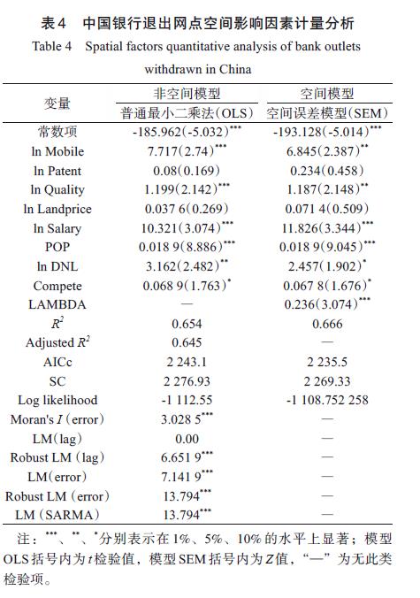
In the context of bank failure, the internet and development trend of financial businesses have notably influenced the banking industry. However, existing literature shows that few studies have quantitatively examined these influences on bank outlets, and the outcomes of studies on the impact of internet on the offline operation of banks have not been authoritatively verified; therefore, further exploration is required. In this context, this study analyzed the withdrawal of offline bank outlets and spatial distribution of bank withdrawals from 2019-2021 using kernel density analysis, geographical concentration index, and DBSCAN clustering algorithm and identified the comprehensive factors influencing bank withdrawals by combining these analyses with a spatial econometric model. This study determined the influences of various factors on the operation of offline financial banks under the background of information development. According to the results: 1) From 2019 to 2020, the withdrawn financial bank outlets revealed aggregated distribution overall, and the number of financial bank outlets that withdrew gradually declined from east to west; given the different conditions in terms of information network impact, different types of bank outlets reported various trends in these changes. 2) The financial institutions that withdrew had some common characteristics from single- and intra-city perspectives. Regarding single cities, In the three regions classified by the level of economic development, large urban agglomerations are the centralized regions where banks withdraw branches, forming the center–edge structure with core cities as the center. From the intracity perspective, more financial banks withdrew in regions with intensive capital, dense population, and developed technology. 3) In the context of mobile information, financial bank withdrawal was influenced by multiple factors. Overall, information environment exerts a strong influence. However, whether innovative ability is related to financial bank withdrawal remains unclear. In addition, the competition, labor, rent, and other operation costs and bank operation benefits from the external market substantially influenced the withdrawal of banks. In contrast to previous studies on the spatial expansion of bank outlets, this study discussed the development characteristics of financial bank withdrawal from the perspectives of time and multidimensional space and additionally considered financial geography, providing subsequent researchers with a reference and guidance. However, limited by data, this study only analyzed and discussed the data of from a 3-year period; the longer-term details of the study object were not summarized. In the future, more abundant data and broader methods will be used to conduct more detailed studies from richer perspectives.
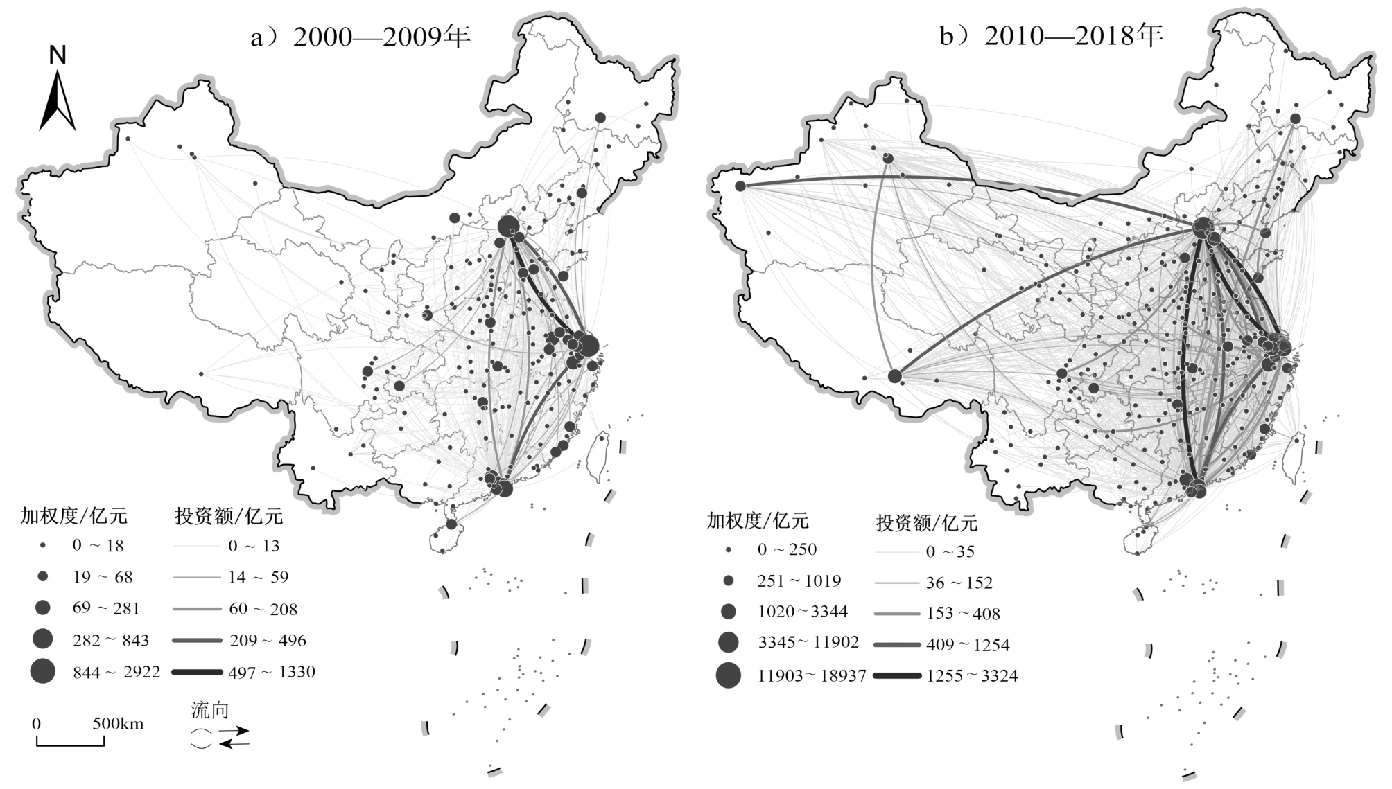
Inter-city Venture Capital (VC) exchange is a micro-embodiment of the cross-regional flow of innovative elements such as capital and technology, and also an important driving force for shaping the network of VC cities. Compared with other types of investment activities, VC has more advantages in promoting the development of innovative industries, especially high-tech industries, and then driving urban economy and regional development; hence, it is widely regarded as a "catalyst" for economic growth and technological innovation. The study of VC networks is helpful in understanding the financial activity links between cities across the country and provides key support for further rational allocation of financial resources between cities. The existing research rarely uses the actual investment amount of VC transaction events between cities to construct the city network. The analysis of the continuous dynamic evolution research and the influencing factors of the overall spatial network structure over a long period of time needs to be strengthened. To compensate for the shortcomings in the above research, this study uses the data of China's inter-city VC flow between 2000 and 2018 to construct the Chinese urban VC network. The long-term spatial evolution characteristics and overall network structure influencing factors of the national inter-city VC network are discussed based on complex network analysis, GIS spatial technology analysis, multiple linear regression model, and so on. This study derives the following results: (1) The connection between cities tends to be closer, and the agglomeration degree of the national VC network increases, displaying obvious characteristics of high aggregation and small-world network. However, the cyber spatial structure of investors/start-ups tends to be flattened, there is a trend of decentralization. (2) The VC connection between cities has expanded from the eastern coastal axis to the central and western regions as a whole, exhibiting obvious characteristics of path dependence and distance attenuation. Additionally, the VC connection continues to sink from the three major urban agglomerations to other marginal cities, and the core node cities of the network also display a tendency of quantitative expansion and power transfer. (3) The city's entrepreneurial foundation, VC industry development level, financial environment, and urban accessibility all have differentiated impacts on the spatial structure of the national VC network. Moreover, the aforementioned are affected by various mechanisms such as multi-dimensional proximity, urban economy, and path dependence, which promote the construction of national and regional VC networks and the formation and evolution of regional capital centers.
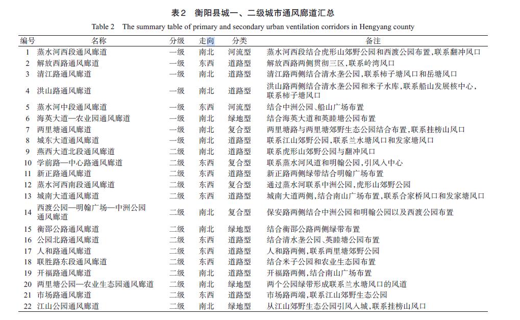
The monsoon climate in southern China is characterized by hot summers and cold winters. These extreme conditions have caught the attention of researchers because of the importance of designing cities so as to strengthen natural ventilation in summer and reduce exposure to cold winds during winter. Not only do the design and construction of urban ventilation corridors lead to the mitigation of the urban heat island effect in summer, the corridors also contribute to reducing atmospheric pollution and the invasion of winter monsoons. This study is specifically concerned with an analytical method that can be used, especially during the planning and design of cities, to improve the urban wind environment. Currently, most urban wind environment studies generally adopt numerical simulations as the investigation method. To some extent, this approach can be helpful with urban wind environment analyses under different planning and design scenarios. Many existing studies indicate that this technique has the advantage of rendering urban wind environment predictions with reliable accuracy. Numerical wind environmental simulations—especially, Computational Fluid Dynamics (CFD) simulation models—have been used for urban planning and design optimization. However, these models have certain limitations about the planning and workflow that the numerical simulation techniques require. For instance, in the early stages of urban design schemes, such as the master planning stage, the workload and amount of time required to perform the necessary repetitive simulations become enormous (not only in terms of time and energy but also with regard to expertise). The thorough and exhaustive numerical simulation task sometimes becomes impossible because of the limitations of computer performance, particularly for large city-scale areas. In this study, Hengyang County, Hunan Province, was selected as the study area. A new method was proposed to reduce the workload, time, and computational equipment requirements for analyzing the wind environment of a large city-scale area during the early stages of urban planning and design. The proposed method starts with the construction of a 3D model of the city using rule-based modeling, followed by a comprehensive evaluation model implemented in ArcGIS to assess the urban spatial enclosure and its influence on urban ventilation corridors. We used the least-cost path to generate ventilation corridors under different wind directions. The measurement points in the ventilation corridors of the city were selected to validate the wind speed cloud map simulated by PHOENICS. The simulation results were basically consistent with the site-measurements, thus demonstrating the validity of the evaluation model proposed in this study. Several findings are derived from this study. First, changes in the urban wind environment should be considered at the early stage of urban design. Second, the choice of rule-based modeling is not only beneficial to the quick modeling of the design scheme but is also efficient for a quick modeling of ventilation corridors. Third, the construction of urban ventilation corridors needs to consider several urban elements. The 8 primary ventilation corridors and 14 secondary ventilation corridors are constructed in the planning scheme according to the different action spaces of the wind corridors. Comparing the wind speed map of PHOENICS and the comprehensive evaluation results, it is proved that the urban ventilation corridor system constructed by buildings, road networks, water, and greenery systems can be quite overlapped with the ventilation corridors, and it also proved that the optimization measures based on wind openings, open space, water, roads, and buildings can effectively improve the ventilation capacity of the planning scheme. The study further demonstrates the limitation of single-criteria evaluation compared to multi-criteria evaluation which is more suitable for the complex urban wind environment. In addition to terrain height differences, the urban spatial enclosure model reflects consideration for building environment factors, such as the sky view factor, absolute roughness, frontal area density, average height, and building density. Thus, we propose a more convenient and effective method for the design of urban ventilation corridors that can be beneficial for achieving green and low-carbon urban planning.
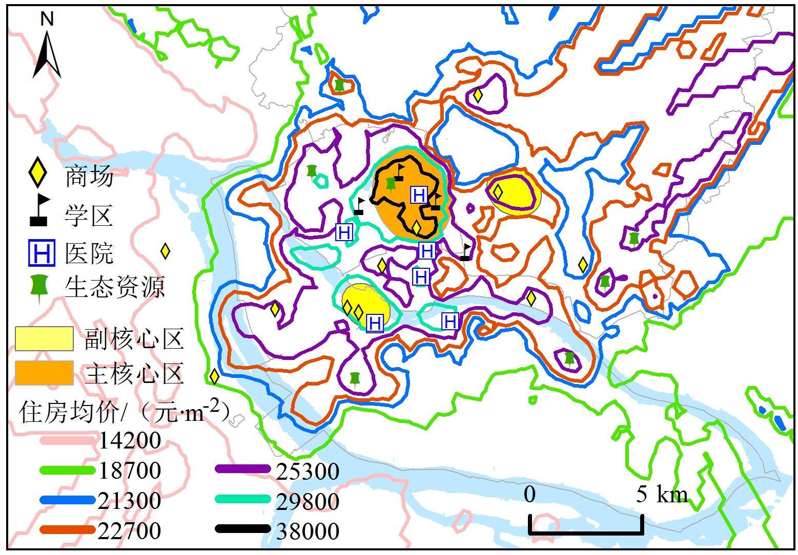
Housing prices are influenced by various factors, which not only have different intensities but also different scale ranges. As a basic category of geographic research, scale is an important parameter for studying the phenomena, and subdividing the intensity of the effects of different types of influencing factors and spatial scales is of great importance for urban planning. Based on the price data of 3,386 commercial housing districts in the central city of Fuzhou in 2021, we used spatial statistics and the Multiscale Geographically Weighted Regression model to explore the spatial distribution characteristics of housing prices and the varying scale effects of influencing factors. The results show that: 1) The housing price in the central city of Fuzhou presents an "inverted U-shaped" curve in the east-west and north-south directions, with symmetry in the east-west direction and large differences in the north-south direction. The spatial pattern is a multi-center urban hierarchy system of "one main center and two sub-centers," and the neighborhoods with high housing prices show the characteristics of "a tendency to gather around the Minjiang River, school district, shopping malls, hospitals and ecological resources." 2) The factors influencing housing prices have distinct spatially heterogeneous and exclusive bandwidths. Building ages, shopping malls, and primary schools are local factors belonging to the street scale; the Floor Area Ratio (FAR) and hospitals are local factors belonging to the district administrative divisions scale; and the subway station, coach station, and university are global factors belonging to the central city of Fuzhou scale. 3) The strengths of the influencing factors, from largest to smallest, are primary schools, building ages, bus stations, shopping malls, FARs, universities, hospitals, and subway stations. Among them, primary schools, bus stations, FARs, and hospitals are positively correlated with housing prices, whereas building ages, shopping malls, universities, and subway stations are negatively correlated with housing prices. These results can provide theoretical basis for urban planners and policymakers. First, urban planning should be based on the principle of "local adaptation," and the planning layout should be adapted to the spatial and distribution patterns of urban housing prices. Second, urban planning needs to account for the function of functional areas for local factors, whereas global factors need to be evaluated and considered on a large-scale spatial scale. Finally, the strength of the influencing factors is also an important aspect of urban planning. For the influencing factors with strong pulling power, such as primary schools, building ages, and shopping malls, the number of resources allocated and the layout of spatial locations need to be planned rationally, and suitable urban planning solutions need to be proposed to finally achieve the goal of steady economic growth and satisfying residents' willingness to buy houses. This study has some limitations related to data acquisition. The analysis of the temporal trends of the influencing factors should be considered in future studies, as well as account for more influencing factors, such as area, floor, and orientation in future research.
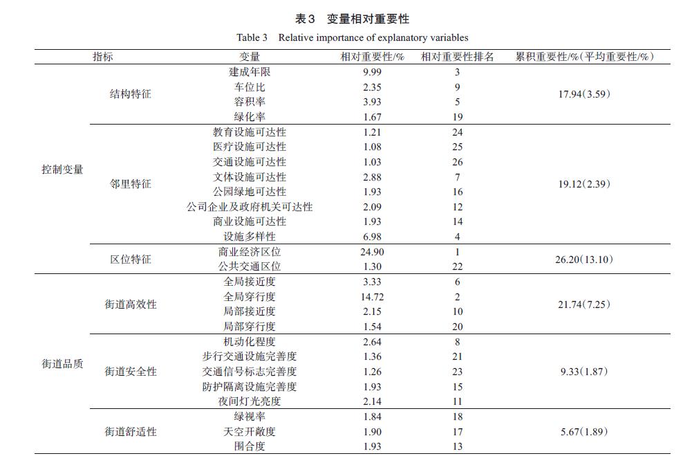
Streets are important spaces for transportation and life. It is important to clarify the economic effects of street quality on the real estate industry to create high-quality street spaces and meet the environmental needs of residents. Based on factors influencing traditional housing prices, such as street quality, this study used the random forest model and an accumulated local effects plot to explore the nonlinear relationship between street quality and housing prices, with its threshold effect in Guangzhou. The results show that the random forest model's fitting accuracy is 0.145 times higher than that of traditional linear methods and that the random forest model effectively captures the nonlinear relationship and threshold effect between street quality characteristics and housing prices. Commercial location, global betweenness, and the years of community construction significantly impact housing prices. The total contribution of green vision rate, sky openness, and enclosure to housing prices reached 5.68%, and residents' preferences for a comfortable environment drew attention. When distance increased, the negative influence of the commercial and economic location on housing prices gradually decreased. When global betweenness is less than 1,715, it has an exponential positive correlation with housing prices. When local proximity exceeds 117, it has little impact on housing prices, revealing the alternative effects of transportation hubs at different levels. Positive externalities, such as convenient transportation and negative externalities, such as traffic congestion and environmental pollution, affect housing prices equally. Road construction should consider traffic efficiency and environmental livability. When the degree of road motorization is less than 23% and more than 26%, the construction ratio of protective isolation facilities is more than 4.27%, and the night light brightness is higher than 0.0037 W/(m2·sr·μm), they have a lesser impact on housing prices. The over-construction of safety facilities reduces the economic benefits of street quality. Moreover, to ensure fair street usage, the green vision rate of the living environment should not be less than 15%. The spatial distribution trends of sky openness and enclosures are opposite, but both negatively impact housing prices. In urban development and construction, the development intensity should be reasonably controlled to avoid psychological depression caused by space cramping. For future street-stock renewal, it is necessary to accurately understand the current situation of street quality and the needs of residents, specifically improving street quality. Avoiding street quality creates property premiums and strives to ensure the fairness of residents' access to and use of street spaces. It guides real estate developers to participate in street construction. This study compensates for the limitations of traditional characteristic price models and the lack of explanatory properties in traditional linear methods, thereby providing a scientific basis for improving residents' living environments and building a livable city.
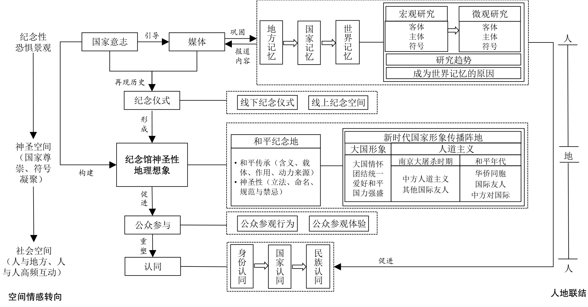
The memorial landscape of fear is a precious heritage of human memory. However, the sense of spatiotemporal distance and non-experience of disastrous events may cause a negative geographical imagination of the commemorative landscape of the site, making its social meaning face a forgotten predicament continually. By applying the grounded theory, this research aims to explore the process and mechanism of constructing a geographical imagination of the sacredness of memorial landscapes of fear under media discourse. Taking the Memorial Hall of the Victims of the Nanjing Massacre as a case study, the results indicate that: (1) online media have expanded the memory of the Nanjing Massacre into a broader spatial and temporal context. In space, the memory of the Nanjing Massacre gradually rises from place memory to the national memory, and eventually to global memory. In time, the memory of the Nanjing Massacre has evolved from a "national shame" in the framework of contemporary historical narratives to a textbook of suffering in the history of human development. In addition, while the media narrated the macroscopic memories of the Nanjing Massacre, they focused on the awakening and transmission of individual memories at the microscopic level, evolving from narrating macroscopic history to interpreting the meaning of microscopic life. (2) Through naming norms, legal exaltation, symbolic construction, and ritual interaction, the state and the media have constructed the Nanjing Memorial Hall entirely as a sacred memorial site for peace and a communication position for the national image in the new era, achieving the transformation from a landscape of fear that triggers negative geographical imagination to a secular sacred space. (3) The memorial ceremony played a significant role in linking subject, memory, and space in the process of constructing the sacredness of the Nanjing Memorial Hall. By participating in memorial rituals, the public connects themselves to memory and collective identity, generating a strong sense of mission and meaning. The contributions of this study are mainly reflected in the following three aspects: First, it deepens the study of the landscape of fear, a special cultural landscape that carries negative emotions of people and places and helps solve the dilemma that the memorial landscape of fear and its social meaning is constantly facing forgetfulness. Second, this study explores the media's and the public's (i.e., "author") construction of the geographical imagination of the sacredness of the memorial landscape of fear and the public's (i.e., "reader") deconstruction of imagination, expanding the scope of geographical imagination research from a micro perspective. Finally, this study explores the role of national memorial ceremonies in constructing the sacredness of memorial landscapes of fear, thus expanding the study of sacred spaces, mostly focusing on religious rituals. These findings are important for the transmission of collective memory and the construction of national identity.
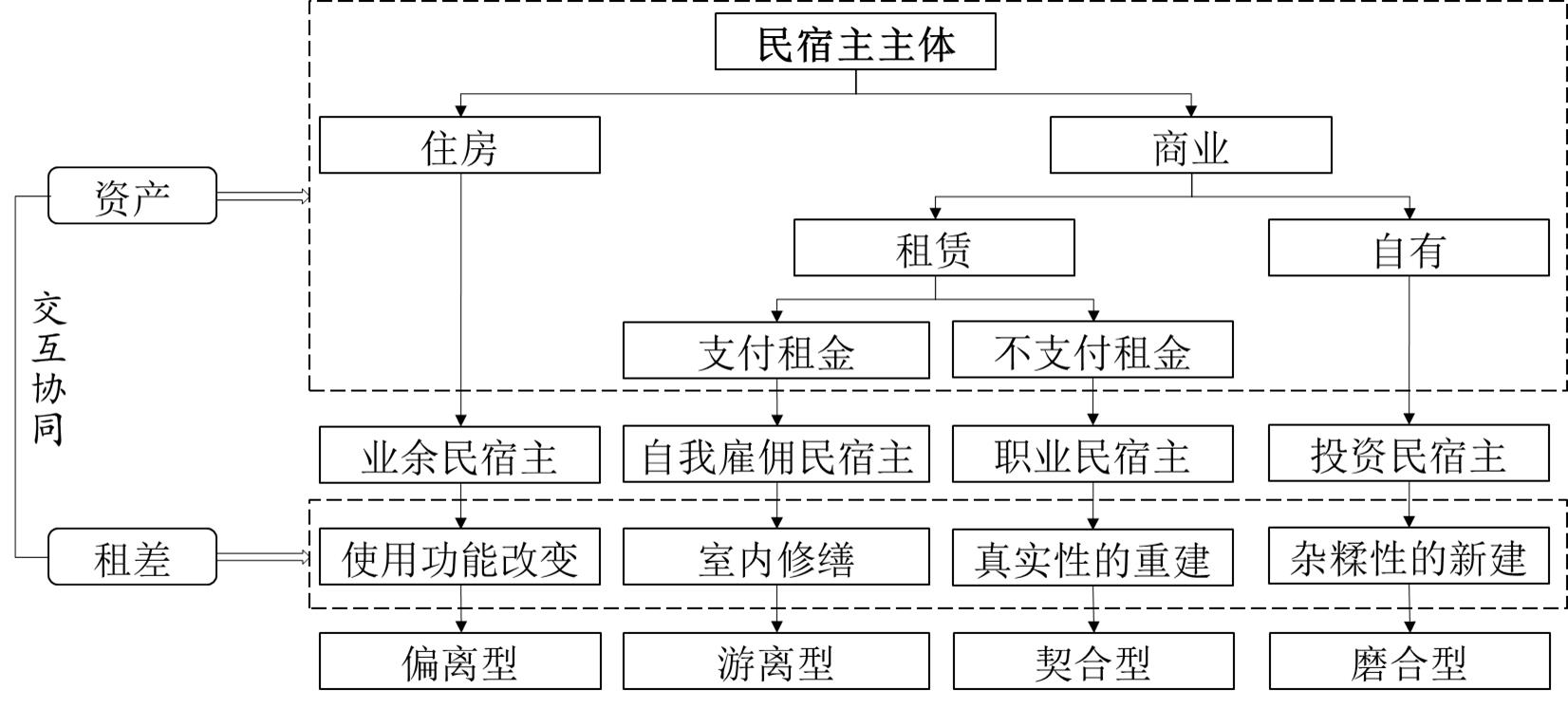
Short-term rentals are the primary drivers of transnational mobility for gentrifiers in the 21st-century. Airbnbification, pioneered by transnational hosts, has emerged in two Pacific small island developing states: Fiji and Vanuatu. Analyzing Airbnbification models driven by transnational hosts in Fiji and Vanuatu is necessary to explore the heterogeneity and internal logic of the social composition of the short-term rental market in marginal areas. Based on the transnational gentrification perspective, this study explores Airbnbification in Pacific small island developing states through an online survey and in-depth interviews with overseas Chinese hosts in Fiji and Vanuatu. The results show the following: 1) Based on assets (the position of hosts on the asset-based social scale; the function of the property and ability to benefit from holding the property) and rent gap (rising potential ground rent by the redevelopment of property), four actors-the amateur, the self-employed, the investor, and the professional hosts-have been identified. The continuum of deviation, dissociation, adaptation, and integration was mapped, showing heterogeneity in group attributes, behavioral intentions, and practical actions. The amateur and the self-employed hosts maintain an intermediate position within the social stratification system and the related consumption patterns by managing their housing assets in "long-term-let (loans) to short-term-let." Investor hosts are immobile transnational elites under the Belt and Road Initiative. Instead of adopting a buy-to-leave investment strategy, they are directly or indirectly involved in the operation and management of guesthouses, but with unsatisfactory returns. The professional host uses collective land provided by local chiefs for guesthouse development, construction, and operation and management, without changing land property rights or involving land sales and leases; they share the proceeds according to the operating income, drive indigenous people to operate guesthouses, and promote the local short-term rental market. 2) Transnational hosts are dynamic participants of Airbnbification, maintaining middle-class status or even achieving an upward transition by property ownership or usufruct, demonstrating democratization of the asset-based economy supported by digital platforms, which does not induce direct last-resident displacement, questioning the use of direct displacement as an important core concept of Airbnbification or even gentrification. 3) Short-term rentals in the Pacific small island developing states are relatively low, and short-term rental platforms, to some extent, realize the sharing economy and are gradually moving towards non-standard online accommodation agents. This study explores Airbnbification in two highly tourist-dependent economies not yet affected by over-tourism, goes beyond the typical Western context, clarifies the role of transnational hosts in Airbnbification, and improves its study. It elaborates on the similarities and differences in Airbnbification between Pacific small island developing states and developed countries in Europe and the United States, expanding the Airbnbification theory and contributing to its localization.
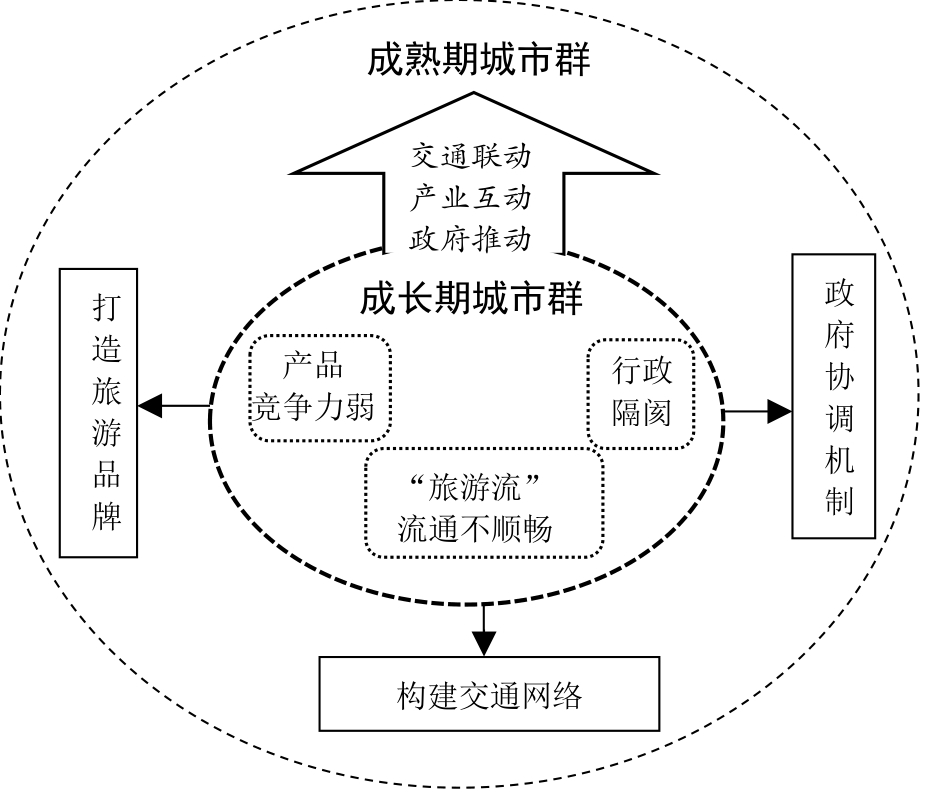
The strategic position of the Beibu Gulf urban agglomeration has become increasingly prominent in terms of national economic development. In this paper, we propose the life cycle theory of urban agglomerations from the perspective of tourism-economic linkages and study the evolution of tourism-economic linkages and the spatial structure of emerging urban agglomerations in the Beibu Gulf using a modified gravity model and social network analysis. The results show the following: 1) The tourism-economic connection of the Beibu Gulf urban agglomeration was initially limited to neighboring cities dominated by provincial capital cities. Nanning is the main location for developing the tourism economy. With improvements in traffic and the implementation of national policies, tourism-economic ties among urban agglomerations have gradually deepened, with the total number of these connections increasing from 174.84 to 6,542.94 in 2019. The total number of connections in 2019 was 37.42 times that of 2011. The tourism-economic connection structure developed from a loose to a multicore network structure. 2) The density of the tourism-economic connection network in the Beibu Gulf urban agglomeration increased by 6.01 times. The network structure changed from loosely to relatively closely connected, and the degree of tourism economic connections has continuously improved. Moreover, the scope of the core area of the tourism economy continues to expand. The internal network density of the core area increased to 0.833 in 2019, and the links between the core areas continue to strengthen. Although the network density in the fringe area has increased, the internal tourism-economic connection remains weak. 3) The spatial structure of the Beibu Gulf urban agglomeration has evolved from a single center in Nanning to a network-type spatial structure of three centers, seven nodes, and five edges. Nanning, Zhanjiang, and Haikou are important tourism centers and growth poles. The centrality of urban agglomerations has changed from severe polarization and disparity in development status between cities to a more balanced development trend. Among the cities under the jurisdiction of Hainan, except for Haikou, the development of the tourism economy is relatively slow. 4) The Beibu Gulf urban agglomeration entered its growth stage after its embryonic development. However, its development still faces three obstacles: administrative barriers, low competitiveness of tourism products, and unobstructed tourism flow, and it remains far from becoming a mature urban agglomeration. This paper proposes an optimized development mechanism for the Beibu Gulf urban agglomeration of government promotion, transportation linkage, and industrial interaction that is conducive to the high-quality development of the Beibu Gulf urban agglomeration. In conclusion, the main content of this study can compensate for the lack of research on the spatial structure of tourism-economic linkages in emerging urban agglomerations to a certain extent and provide a reference for the development of urban agglomerations in the embryonic and growth stages.
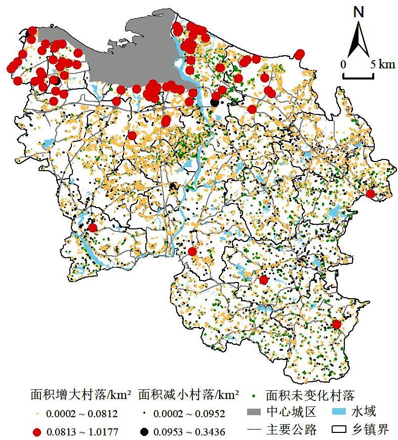
The factors influencing the spatial evolution of rural settlements have always been the focus of rural geography. China's rural settlement space has undergone dramatic changes driven by rapid urbanization in recent decades. However, the spatial heterogeneity and scale effects of the factors influencing the spatial evolution of rural settlements have not attracted widespread attention and in-depth research from scholars. Taking Haikou City as a case example, this study examined the spatial heterogeneity of the factors influencing the spatial evolution of rural settlements from 2002 to 2020 using the remote sensing image visual interpretation method, spatial analysis technology of Geographic Information System (GIS), and Multi-scale Geographically Weighted Regression model. The study showed that: (1) The area of rural settlements in Haikou City has increased by 53.5% in the past 20 years, and the per capita area has grown from 120.59 square meters per person to 166.79 square meters per person, with the characteristics of expansion in the north and contraction in the south, a scattered settlement landscape, and obvious spatial heterogeneity. Moreover, the distribution and area changes of rural settlements showed a significant positive spatial agglomeration pattern. (2) The influences of various factors have obvious differences on spatial non-stationarity and scale effects with bandwidths ranging from 69 to 10 482. The effects of four factors, location, distance to road, distance to real estate development area, and elevation, on the spatial evolution of rural settlements are at the local scale. The effects of two factors, urbanization rate and slope, are at the mesoscale, and the effects of five factors, distance to the central city, population change rate, distance to river, road network density, and accessibility of tourist resource points, are at the global scale. Among these, the spatial evolution of rural settlements is most sensitive to location. (3) Factors such as the impetus of the central city and the development of real estate have the most important impact on the spatial evolution of rural settlements. In addition, settlements are increasingly expanding to areas closer to the central city, closer to real estate development zones, and closer to areas with lower altitudes, smaller slopes, higher levels of urbanization, and higher densities of road network. However, factors such as distance to river, population change rate, and accessibility of tourist resource points have no significant effects on the evolution of rural settlements. (4) Changing the development concepts led by the real estate industry and strictly implementing the "One household, one house" system are important measures to curb the disorderly expansion of rural settlements in Haikou City effectively.
Owing to the effects of rural tourism and urbanization, the frequent participation of external market activities in traditional villages has increased the sensitivity and fragility of villages. This study constructs a Bayesian network model for systemic risk adaptation in traditional village industries by selecting relevant driving factors based on the nexus causality of "risk perturbation-adaptation process-adaptation outcome," using 148 Traditional Villages in She Xian, Huangshan as the experimental sample. Through simulations of adaptation under low-, medium-, and high-risk scenarios, the relationship and degree of influence between the drivers in the network model were quantified, and the adaptation mechanisms of the risk of the traditional village industry system were predicted and analyzed. Finally, ideal development methods for the current traditional villages in She Xian were proposed using the selected primary drivers. The primary findings of the study are as follows: 1) Most of the traditional villages in She Xian are in the middle to high level of industrial system risk, and show a certain advantageous concentration in space. 2) Under the low risk scenario, the ecological and cultural resources of traditional villages are effectively protected and utilized. The allocation of all parts of the industrial system is coordinated, and the ability to adapt and self-organize plays a greater role in adaptive capacity. Key traditional village subjects should be linked internally and externally in future endeavors, and joint efforts should be to made build regional tourism brands. 3) Under the medium risk scenario, traditional villages have slow economic development but stable social organization base, wherein the adaptive capacity of learning self-organization and buffering capacity have a greater impact. Traditional villages with medium risk should concentrate on activating the internal dynamics of villages and improving public services and infrastructure. 4) Under the high risk scenario, traditional villages face difficulties in industrial development and that the risk-coping mechanisms and reproduction logic of traditional villages lack the requisite social foundation. It is therefore vital to make conservation and restoration a top priority and strengthen the intervention of external factors for high-risk villages. The incorporation of Bayesian network theory into the risk assessment of traditional villages can improve current understanding of the diversity and complexity of traditional village risk adaptation process subjects and the dynamics of uncertainty influencing factors, thereby providing new ideas and theoretical references for Industrial transformation and long-term risk management of traditional villages in similar regions.

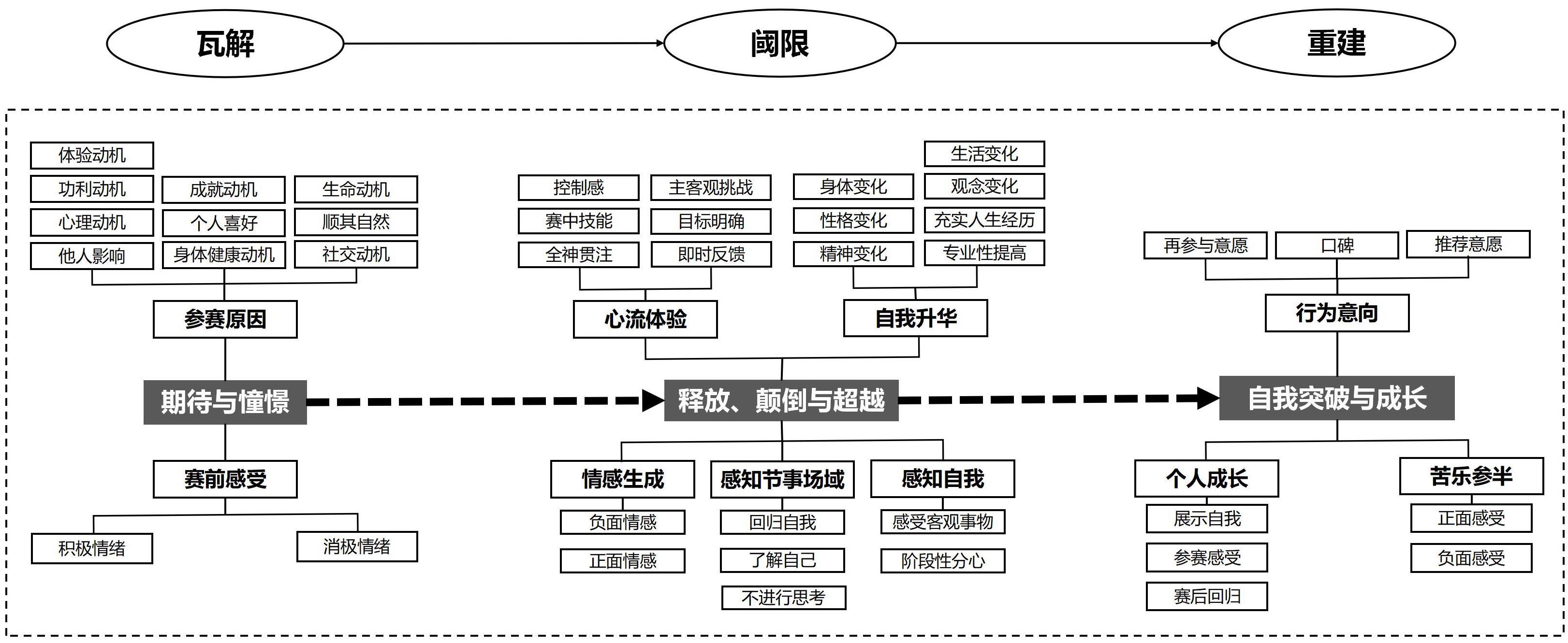
Event experience is an important topic in event research. Liminal experience, as the core experience of event participants, remains limited in research on mass sports events. Taking liminality theory as the logical starting point and marathon participants as subjects, this study collected data through interviews and analyzed it under the guidance of grounded theory. Forty secondary categories and ten main categories were extracted to construct a model of the liminal experience for marathon participants. The results show that the liminal experience of marathon participants can be regarded as a gradual process of "anticipation-release, inversion, and transcendence-self breakthrough and growth." The participants broke away from their daily structure with anticipation for the event and expectations of good self-performance. They immersed themselves in liminal experiences through perception, interaction, release, catharsis, transcendence, and inversion. Finally, the participants experienced a bittersweet experience, emotional sublimation, and personal growth. They were willing to promote and pass on their experiences. The research is innovatively based on marathon participants' event experience, interprets their experience from the perspective of embodied theory, explains the construction process of marathon participants' liminal experience, and enriches the research content of the liminal theory. This study observed that the marathon participants' experience is a liminal experience; however, it differs from other liminal experiences in that the participants have a flow experience and an individual self-breakthrough and growth in the liminal experience, which are difficult to produce in other events. Therefore, the theoretical value of this study is to supplement the research on the experiences of participants and liminal experiences in the field of events. The liminal experience conceptual model constructed in this study clearly shows the performance of participants at various stages, identifies key dimensions of their behavior, and lays the foundation for subsequent empirical research. The practical value of this research is that, through interviews with marathon participants, we learn about the views of amateur competitors on mass sports events. Most of them have service requirements, and organizers must continuously improve their ability and level of organization to provide participants with a good experience. Operators, sponsors, and other relevant organizers of mass sports events create a favorable atmosphere through policy support, financial support, and promotion, which helps participants enter the liminal state and immerse themselves in the event.
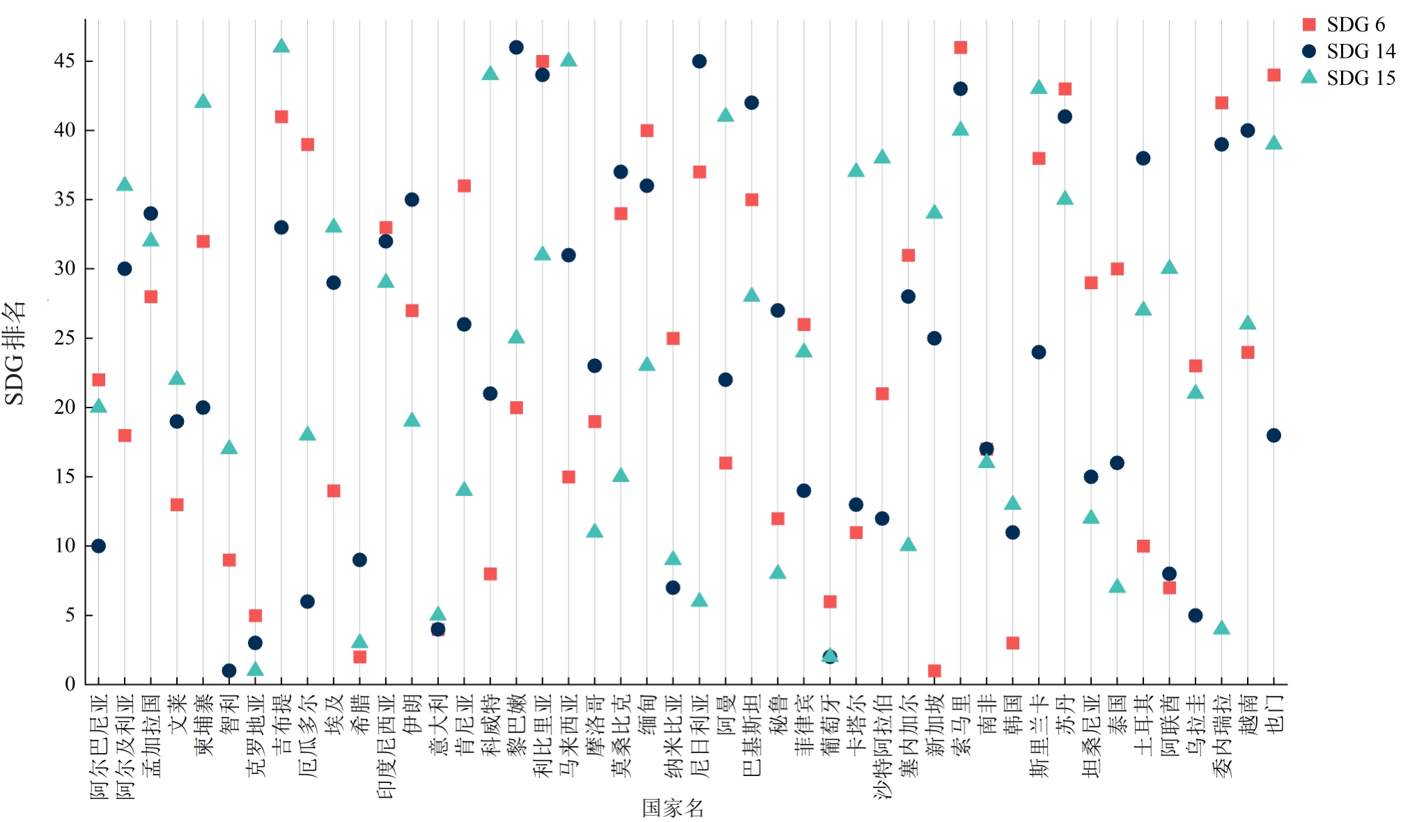
The Maritime Silk Road (MSR) plays a significant role in international trade and the global economy, contributing to achieving the United Nations Sustainable Development Goals (SDGs). However, most countries along the MSR are developing nations and emerging economies with high natural resource consumption and fragile environments and face conflicts between economic development and environmental protection. In this context, understanding the status of natural resource utilization in MSR countries is important to advance sustainable development in these countries and promote the construction of the Green Belt and Road, and global environmental governance. Focusing on SDGs 6 (water), 14 (life below water), and 15 (life on land), this study constructed an indicator framework for assessing the sustainable use of natural resources with 24 targets and 42 indicators. Strong and weak sustainability concepts were introduced, and the constant elasticity of substitution function and combined compromise solution method were used to assess the sustainability of natural resource use for 46 countries along the MSR in 2020. The results showed that: (1) the scores in the weak sustainability scenario were higher than those in the strong scenario. The differences in the target scores between the two sustainability scenarios revealed unevenness among the indicator scores. Strong sustainability prefers balanced performance across indicators over weak sustainability. (2) MSR countries performed poorly on targets 6.3 (Improve water quality), 6.4 (Water use), 6.5 (Integrated water resources management), 14.1 (Reduce marine pollution), 14.4 (Conserve fish stocks), 14.5 (Protect marine protected areas), 14. a (Develop marine science and technology), 15.1 (Ecosystem systems and services) and 15.6 (Access and share genetic resources); therefore, these countries should increase their efforts in these areas and improve relevant policies and measures. (3) From the perspective of SDG scores, Portugal, Croatia, and Italy topped each SDG, while Sudan, Somalia, and Djibouti lagged. Several countries, such as Singapore, Iran, and Myanmar, show uneven performance. Governments should develop more effective resource development and conservation plans based on their strengths and weaknesses. (4) Regarding final rankings, Portugal, Croatia, and Greece had the best overall performance, whereas Liberia, Somalia, and Djibouti ranked last. Regionally, Europe ranked highest, followed by South America, Asia, and Africa, which are related to their economic development and resource endowment levels. (5) In the future, China and the MSR countries should focus on promoting international cooperation in areas such as water security, blue carbon development, and biodiversity conservation. Furthermore, China should develop targeted investment and cooperation strategies based on the differences in resource use, environmental conditions, and development levels among countries. This study provides a reference for deepening cooperation between China and the MSR countries regarding ecological and environmental protection.
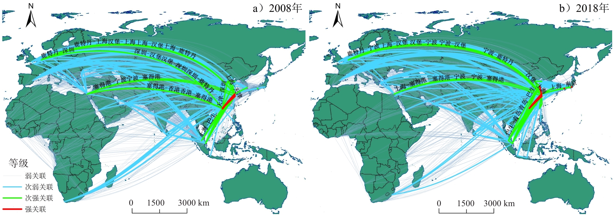
As the most significant international transportation infrastructure, the operation and external links of ports are affected by more complicated aspects, resulting in immense changes not seen in a century. Related studies have long been interested in and have followed the evaluation of port location advantage as a comprehensive response to ports' economic and trade conditions. Location advantage reflects the overall resource advantage of a location. Transportation infrastructure can be evaluated from various perspectives, and the choice of different indicators sets the evaluation slant for its use. A port's ability to operate depends on natural navigational conditions, high-quality infrastructure, an appropriate economic hinterland, favorable geographic relationships, and a global environment. Port location advantage has traditionally been focused on from the perspective of transportation routes, hinterland economy, etc. The geographical proximity of nations also has a significant impact on how ports function in today's complex international development environments. To evaluate the advantages of port location along the route, this study uses the geo-relationships between various countries as well as the physical, functional, and economic links between ports as its research objects. It then homogenizes the national-scale WGI Global Governance Index to ports and incorporates it with port-scale maritime distances and route linkages as an integrated model of the degree of location advantage of the ports, using ports along the Maritime Silk Road from 2008 to 2018 as case studies to show how much the ports' advantage in location affects their significance in the real world international environment. The research findings are as follows. 1) Because of the relative position of the hinterland economy in international economic and trade exchanges, the port location advantage also exhibits some scale-free characteristics, and the quantitative expression of geo-relationships between ports emphasizes the importance of ports. As a representative of Asia's emerging economies, China has added more ports with more significant location advantages. 2) The strength of location connections between ports follows the law of distance attenuation, and the shift in the center of gravity of port location connections to Asia reflects the formation of a port location connection pattern dominated by internal Asia with the development of many emerging economies therein. 3) Comparison with mainstream complex network indicators found that although the concentration of factor flow has been formed under the "flow space" in the era of globalization, primary geographical attributes such as geographical relationships and spatial distance still maintain their independence and do not exhibit spatial imbalance under the influence of the reconstruction of global industries and trade. The location of ports based on geographical relationships and port location dominance avoids the limitations of a single perspective in evaluating port location in the international shipping network and can serve as a new basis for assessing the importance of ports in shipping networks; the expression of geographical spatial relationships fills the evaluation gap of existing network indicators.