Regional coordinated development is a complex, systematic and scientific issue advancing with the time which has attracted much attention. The Guangdong-Hong Kong-Macao Greater Bay Area (GBA) aims to develop into a world-class bay area and urban agglomeration. The development of GBA depends on regional coordinated development to enhance its international competitiveness. At present, the process of globalization has experienced multiple turning points, the regional governance system has been continuously optimized, and the technological innovation has evolved rapidly. The coordinated development of the GBA is facing institutional changes. Therefore, through the systematic analysis of the connotations and mechanisms of the coordinated development of the GBA, this paper describes the three stages of regional coordinated development since 1978, including the integration of regional production factors represented by the ‘front shop, back factory’ mode (1978-1996), the regional system integration led by institutional cooperation (1997-2014), and the regional all-round integration guided by national strategy (2015- ). In the meantime, the paper analyzes the five dimensions of the coordinated development of the GBA in the new period, including industrial collaborative innovation, environmental collaborative governance, resource collaborative allocation, service collaborative sharing and institutional collaborative arrangement. These five dimensions are helpful to understand the key areas to promote the coordinated development of the GBA in the coming decades. Furthermore, this paper holds that the regional coordinated development of the GBA is undergoing mechanism changes at four levels, which are mainly reflected in the transformation of globalization, the integration of the internal and external market, the rescaling of governance, and the energization of regional in-depth development facilitated by the new infrastructure. These institutional changes have the potential to generate a new model for the coordinated development of the GBA. This paper takes into account the retrospective review and forward-looking prospect on the coordinated development of the GBA, aiming to provide an entry perspective and analysis framework for related issues.

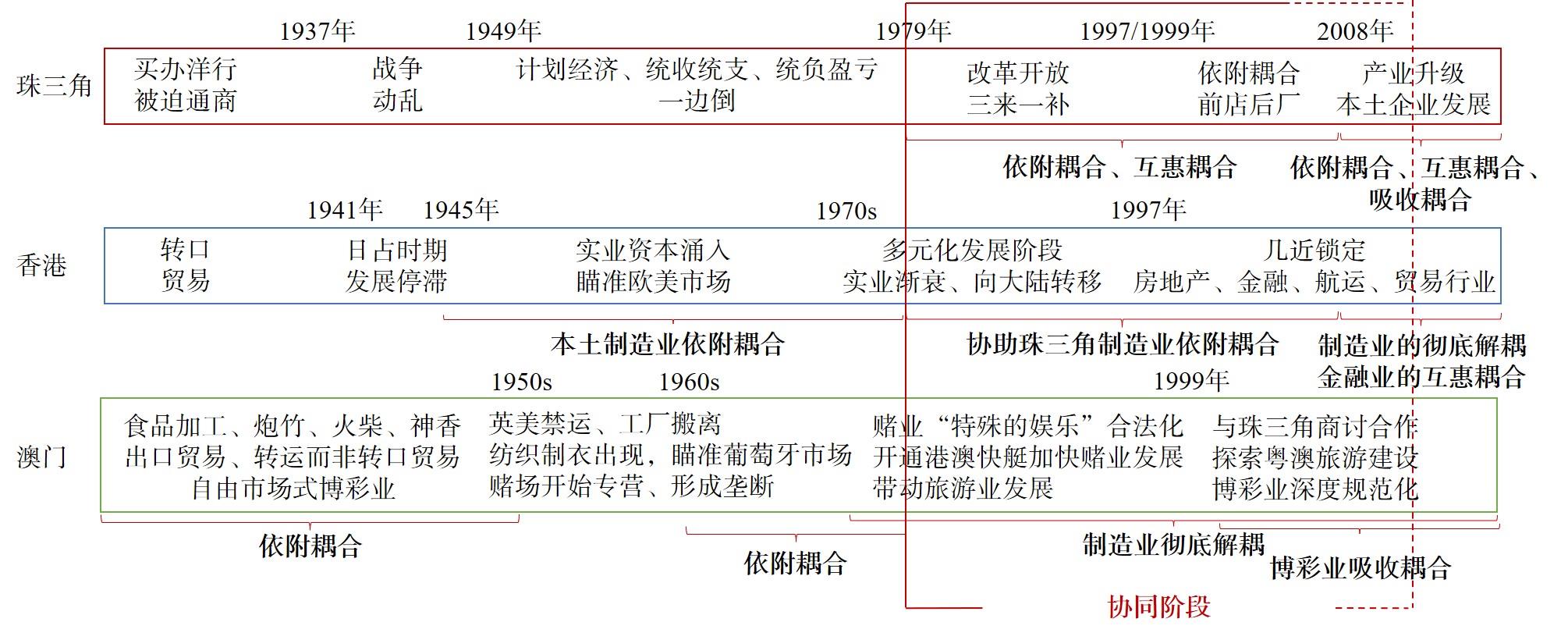
The current research on regional collaboration lacks the research perspective of global production network, which makes it difficult for the research on the collaboration of the Guangdong-Hong Kong-Macao Greater Bay Area to recognize the differences in the development of strategic coupling modes of various cities in the Greater Bay Area, and to clarify the differences in the status and division of labor of these cities in the global production network. These differences are the key to the coordinated development of the Greater Bay Area. Therefore, based on the theoretical framework of the global production network, this study uses the variable of strategic coupling to analyze the development of the strategic coupling mode of the cities in the Greater Bay Area and the differences in their status and division of labor in the global production network, so as to further understand the coordinated development of the Greater Bay Area. There are three main findings in this study. First, the strategic coupling mode and evolution process of Guangdong, Hong Kong and Macao are essentially different, belonging to different global production networks. Hong Kong has experienced two processes of dependency coupling to decoupling in the development of local manufacturing and the later "having stores in front and factories behind" mode, forming a mutually beneficial coupling mode in the financial industry. Macao has experienced two processes from dependency coupling to decoupling in the manufacturing industry, forming an absorption coupling mode in the gambling industry. Second, there are also significant differences in the strategic coupling modes of cities in the Pearl River Delta. Each city is embedded into different global production networks through different leading industries. Third, under the influence of the strategic coupling differences of the above two scales, the regional economy of the Greater Bay Area does not gradually move toward coordinated development, but presents the characteristics of less connection-collaboration-collaborative difficulties. The core argument of this paper is that the differences of strategic coupling mode lead to the embedding of cities into global production networks with significant differences in economic cycles, production systems and technological structures, making it difficult to achieve the overall regional collaboration. And the contribution of this study is that with the help of the global production network theory, it provides a new interpretation perspective for regional collaboration research, reveals the difficulties of regional collaboration in the Greater Bay Area, enriches the study of the long-term dynamic evolution of relational economic geography, and provides some suggestions for the formulation of collaborative policy.
The dynamics of innovation in geographical space is closely related to the regional development trajectory. Evolutionary economic geography points out the path dependence characteristics of regional development, and emphasizes that the direction of regional development is rooted in the original industrial and technological structure characteristics. Therefore, the geographical pattern of technological innovation and the identification of its diversity characteristics are of significance to the realization of regional innovation and the evolution of industrial structure. From the perspective of strategic industry, this paper aims to reveal the geographical pattern and diversity characteristics of technological innovation in strategic industry in the Guangdong-Hong Kong-Macao Greater Bay Area (GBA). Based on the point scale spatial data of invention patents in the GBA and by means of connecting strategic industry with national economy industry classification code and patent IPC classification code, the invention patents of six major industries in the GBA are extracted, which are the new generation of electronic information industry, automobile industry, green petrochemical industry, new energy industry, advanced material industry and intelligent robot industry. And the nuclear density analysis, standard deviation tail value test, entropy method and average nearest neighbor distance analysis are used to identify the spatial distribution characteristics and differences of multiple types of technological innovation in the GBA. The results show that the geographic pattern of technological innovation in the GBA presents a significant spatial imbalance. At the regional scale, Guangzhou and Shenzhen are the two agglomeration cores. There is a large gap in the innovation ability between the east and west sides of the Pearl River. The accumulation of technological innovation on the east bank is much higher than that on the west bank. The innovation profile line on the east bank has formed two obvious peaks in Guangzhou and Shenzhen. The high value of the innovation profile line on the west bank is mainly concentrated in Guangzhou and Zhuhai, and the peak value is far lower than that on the east bank. The location of technological diversity is mainly distributed in the core areas of the GBA, mainly including Yuexiu District and Tianhe District in Guangzhou, Nanshan District and Futian District in Shenzhen, Binhai District in Dongguan and Xiangzhou District in Zhuhai. And the distribution characteristics of technological innovation data of different industrial types are different. The innovation of the new generation of electronic information industry, advanced materials industry and green petrochemical industry accounts for 51.67% of the total innovation in the GBA. The innovation of different technological types shows obvious spatial differentiation. The innovation agglomeration degree of the new generation electronic information industry is the highest, with the R value of 0.0576. And its observed value of the average nearest neighbor distance between invention patents is 32.03 m, which belongs to the minimum value in the selected analysis industries, showing strong agglomeration characteristics. There are differences in the distribution characteristics of the agglomeration core of the six major industries in the GBA. The common ground is that they have formed the largest two agglomeration cores in the core areas of Guangzhou and Shenzhen, covering Yuexiu-Tianhe area in Guangzhou and Futian-Nanshan-Luohu area in Shenzhen. And the spatial distribution is mainly concentrated in the core areas of Guangzhou, Shenzhen, Dongguan and Zhuhai. Among them, the spatial agglomeration degree of the new generation of electronic information industry innovation is the highest. Agglomeration and multi-dimensional proximity, diversity and path dependence are the main mechanisms for the formation of the geographical pattern of technological innovation in the GBA, and these two key mechanisms promote the formation of current multi-type technological innovation space in the GBA.
The rapid development of global transportation network and information communication technology has an important impact on regional economy and social spatial structure, and promotes the transformation of regional research paradigm. The coordinated development of urban agglomeration and regional functional linkage from the perspective of flow space has become an important issue in urban regional research. Different from the traditional central place theory that emphasizes the differences in scale and level of cities within the region, the flow space perspective helps to understand how the regional factor flow organizes cities of all scales and levels in the form of network with the background of space-time compression, and promotes the functional linkage and coordinated development within the region on the basis of reshaping the urban spatial relationship. Based on the literature review of relevant research at home and abroad, this paper constructs an analytical framework for the relationship between regional spatial factor flow and function collaboration, and discusses the regional function collaborative mechanism of urban agglomeration from three aspects: "how to reshape the regional spatial network by factor flow", "how to restructure the urban hierarchy by infrastructure connectivity" and "how to strengthen the regional functional linkage by functional complementarity". On this basis, taking the urban agglomeration of San Francisco Bay Area as an example, this paper discusses the evolution progress of San Francisco Bay Area from "single center agglomeration development" to "double-core symbiotic evolution", "polycentric development" and "generic network functional linkage development" from three aspects of liquidity, connectivity and complementarity. The study found that: 1) In the first stage (before the 1930s), fact flow strengthened the connection between San Francisco and Oakland, connectivity improved the status of Oakland, and functional complementarity promoted the symbiosis of the two cities. 2) In the second stage (1940s-1980s), the flow and converge of factors towards the south bay promoted the tripartite growth of San Francisco, Oakland and San Jose, transport connectivity strengthened the core-peripheral connection, and factor convection and functional reciprocity promoted the multi-center linkage development. 3) In the third stage (since 1980s), factor distribution and transportation network connectivity contributed to the generic network spatial structure, dislocation and complementary development strengthened the regional circulation and realized the functional linkage of the Bay Area. Based on the perspective of flow space, this paper reviews the basic situation of the development of world-class bay area urban agglomerations and excavates the internal mechanism of regional functional coordinated development driven by factor flow, which has reference significance for guiding China's cities from competition to competition and cooperation and establishing a new mechanism of regional coordinated development. The research shows that to promote the development of China's bay area in the future, we should: 1) Comply with the law of factor flow, innovate the mechanism and remove barriers to factor mobility, and promote the free flow of factors inside and outside the region; 2) Give play to the guiding role of the government and non-governmental organizations to improve the connectivity of software and hardware infrastructure within the region; 3) Explore the regional consultation mechanism, break through the regional administrative barriers, and formulate the regional development strategy of functional complementation and linkage with the help of multiple subject forces.
On the basis of fully understanding the scientific connotation of coordinated development of urban agglomeration in the Guangdong-Hong Kong-Macao Greater Bay Area, the evaluation index system of coordinated development is constructed from four dimensions: industrial coordinative innovation, environmental coordinative governance, service coordinative sharing and institutional coordinative arrangement. The theory and method of space of flows, big data, network analysis and interlocking network model are comprehensively used to quantitatively analyze the interurban relationship, liquidity, connectivity and boundary effect. The research shows that: 1) Interurban capital flow is concentrated between Guangzhou and Shenzhen, and interurban knowledge flow is concentrated among Hong Kong, Guangzhou and Shenzhen. Macao, Zhuhai, Zhongshan and Jiangmen have higher level of collaborative environmental governance, while Shenzhen-Dongguan-Huizhou and Guangzhou-Foshan have lower level of collaborative environmental governance. The interurban service coordination sharing level of infrastructure such as transportation, communications, logistics and banking is higher among cities of Guangzhou-Shenzhen, Guangzhou-Foshan and Shenzhen-Dongguan. And Hong Kong and Macao have institutional advantages in cross-border regional coordination. 2) Guangzhou and Shenzhen, Guangzhou and Foshan, Shenzhen and Dongguan, and Hong Kong and Shenzhen have the best level of coordinated development in the Guangdong-Hong Kong-Macao Greater Bay Area. At the same time, Guangzhou and Dongguan, Shenzhen and Foshan show a linkage trend. Although the de-boundary trend is obvious and the interurban liquidity is enhanced, the coordinated development level of the Guangdong-Hong Kong-Macao Greater Bay Area is generally not high. 3) The collaborative capacity of Guangzhou and Shenzhen is the strongest, and there is still much room for improvement in the collaborative capacity of the two international cities, Hong Kong and Macao. It is of great practical value to deeply understand the typical characteristics and potential trends of the coordinated development of urban agglomeration in the Guangdong-Hong Kong-Macao Greater Bay Area for the construction of international first-class bay area and world-class urban agglomeration.

Urban tourism network structure is an important part of regional development research in China. However, previous studies have paid more attention to the urban tourism network structure characterized by physical indicators driven by government forces, ignoring the importance of virtual space network in the information age. Under the background of high-quality tourism development, urban agglomeration tourism should change from "hard connectivity" to "soft connectivity". The soft index represented by information relationship redefines the new urban tourism network and can better reveal the characteristics of regional tourism integration under different market dimensions from the perspective of "dual cycle". As the data acquisition of the Guangdong-Hong Kong-Macao Greater Bay Area (GBA) is faced with many obstacles, the active tourism information relationship data in the Internet has brought new ideas to study the urban tourism network structure of the region. This paper constructs the data collection method of "city+city+tourism" based on the keyword co-occurrence in bibliometrics, the co-reference linkage in global urban network research, and the data collection method of "city+tourism" in online tourism research. Baidu Chinese search engine and Google English search engine are used to obtain the co-occurrence frequency of urban tourism information in the GBA. And the social network analysis method is used to explore the similarities and differences of urban tourism information connection strength and network structure characteristics from the domestic and international tourism market dimensions. The results show that the intensity and mean value of urban tourism information connection in the GBA increase gradually. The accumulation and diffusion of tourism information in the network, the information interaction and network relevance have been significantly improved. The trend of regional tourism integration is obvious, and the information connection pattern of domestic tourism market is more stable. The cities in the GBA have different network advantages in domestic and international tourism markets, and there are differences in tourism function division and market influence. It has formed a tourism market pattern in which the second tier cities with Dongguan, Foshan, Zhongshan and Zhuhai as the center lead the internal linkage, and the first tier cities such as Guangzhou, Hong Kong, Shenzhen and Macao lead the opening to the outside world. The core cities in the GBA have different modes of leading the development of small groups in domestic and international tourism markets. The tourism cooperation mode driven by the agglomeration of second tier cities such as Foshan, Zhongshan, Dongguan, Zhuhai and Huizhou dominates the domestic tourism market, and the first tier cities represented by Hong Kong, Guangzhou, Shenzhen and Macao cooperate with other cities to form a tourism linkage mode that dominates the international tourism market. In short, this paper uses the tourism information relationship data to break through the constraints of geographical distance, policy and economic development level, and reflects the hyperspace-time characteristics of urban tourism information network. In the field of tourism, it reveals the network structure of urban agglomeration reflected in the massive web content at home and abroad, which is a tourism functional organization system with clear division of labor and strong points. As a low-threshold information channel, the Internet gives the second tier cities in the domestic tourism market the opportunity to "flip", and the state of "the strong is always strong" in the first tier cities in the international tourism market will continue to exist, which makes this paper reveal the differences in the Matthew effect of tourism destinations in different market dimensions from the perspective of virtual space.
This paper focuses on the internal hierarchical structure of the port group in the Guangdong-Hong Kong-Macao Greater Bay Area and the external connection patterns of the region. This article considers the Greater Bay Area port cluster as its research object, uses regional container port throughput data , global shipping network route data, and social network analysis methods to study the relative indicators of the cluster's internal port throughput. The results show that: (1) the total port throughput of the Greater Bay Area increased by 32.3% from 2007 to 2020, and reached 72.94 million TEU(Twenty-foot Equivalent Unit) in 2020, accounting for 9.2% worldwide and 28.3% for China. Among them, Shenzhen and Guangzhou ports are experiencing rapid growth. The port group of the Greater Bay Area occupies an important position in national and global maritime markets. (2) In terms of participation in the global shipping network, the Greater Bay Area has emerged as a hierarchical structure with Shenzhen and Hong Kong ports as the core in the eight global shipping regions. The Greater Bay Area has the closest connection with East and Southeast Asia, while its routes to Europe, America, Africa, and other regions are limited to the direct connection between regional core ports. (3) Shenzhen, Hong Kong, and Guangzhou within the Greater Bay Area port group will be firmly established, and their major businesses will be developed simultaneously. Shenzhen port, an international container transport hub in Hong Kong, a foreign trade port and a comprehensive domestic trade port in Guangzhou, and other regional ports, such as Zhuhai and Dongguan, will be jointly developed. The rapid development of the port group in the Greater Bay Area has provided important support to the country's construction of the 21st-century Maritime Silk Road Economic Belt. It has formed a multi-level structure with Shenzhen, Hong Kong, and Guangzhou as the core, and the leading ports play an important role in the internal market and external shipping links. In the future, the positioning and regional coordinated development among Hong Kong, Shenzhen, and Guangzhou ports will become the key to the overall competitiveness of the port group in the Greater Bay Area. In future development, the regional integration of port groups will surpass the competitive pattern among them. Instead of competing, Shenzhen, Guangzhou, and Hong Kong should break down barriers and integrate port resources to combine the advantages and allocate them efficiently. The port group of the Greater Bay Area urgently needs to adjust its internal development pattern to meet the unknown opportunities and challenges of globalization.
Taking the waterage passenger transportation lines in the Guangdong-Hong Kong-Macao Great Bay Area (GBA) as the data source to study its complex network characteristics can enrich the traffic geography research based on waterage passenger transportation and serve the construction of the GBA. The findings are as follows. Firstly, the waterage passenger transportation network (WPTN) in the GBA is basically sound with nodes flowing freely, but the network lacks in hierarchy as nodes with low accessibility occupy the majority and is overally dispersed with low-level modularization. The complex network can be divided into two communities, of which the nodes with the highest degree are China Ferry Terminal (CFT) in Hong Kong, Hong Kong International Airport (HKIA) and Shekou Port (SP) in Shenzhen, and the nodes most closely connected are HK Macao Ferry Terminal (HMFT) and Macao Outer Harbour Ferry Terminal (MOHFT). Secondly, the WPTN in the Great Bay Area has characteristics of some small world network and scale-free, of which the node distribution presents the "Matthew Effect". The average path length of the network is small, and the clustering coefficient is also small. CFT, HKIA and SP are the head nodes of the WPTN, which have the most growing feature and priority connection feature in the network. On the other side, it also shows that the internal differences of the complex network are large and the overall connectivity quality needs to be improved. Thirdly, SP is the most important node in the complex network , as its various indicators are all at the forefront. The positions of CFT, HKIA, Jiuzhou Port in Zhuhai and MOHFT in the complex network are also very important, and they have outstanding advantages in a single indicator respectively. Fourthly, from the perspective of spatial structure, the waterage passenger transportation capacity in the south of the GBA is more developed than that in the north, and that in the east is more developed than that in the west. And finally, the WPTN in the GBA has robustness and strong survivability, but the network development is not perfect enough with greater vulnerability, as the network connectivity depends too much on the core nodes and the stability is poor. After attacking the core nodes of the network, half of the remaining nodes will be greatly affected, and even some nodes become isolated ones. After calculation, there are only 31.34% of the complex network variables remained after event 3. In order to optimize the WPTN in the Great Bay Area, the suggestions are list below. First, for various core nodes, such as CFT, HKIA, SP and MOHFT, as they play important roles in the network, it is necessary to strengthen support to ensure their service capacity. Second, for edge nodes, such as Lianhuashan Port and Nansha Port in Guangzhou, Shunde Port and Gaoming Port in Foshan, we can make full use of the attraction and radiation of the city itself, fully investigate the market demand and develop new passenger transportation lines, especially increase the connections with non-core nodes and improve their position in the network, so as to enhance the stability and external attack tolerance of the whole network. And third, from the perspective of spatial pattern, it is necessary to focus on improving the waterage passenger transportation capacity in the north of the GBA and form a northern hub, in order to make the whole network more balanced. For future studies, we can focus on the evolution process and impact of the WPTN and the comprehensive research of waterage and land passenger transportation network as well.
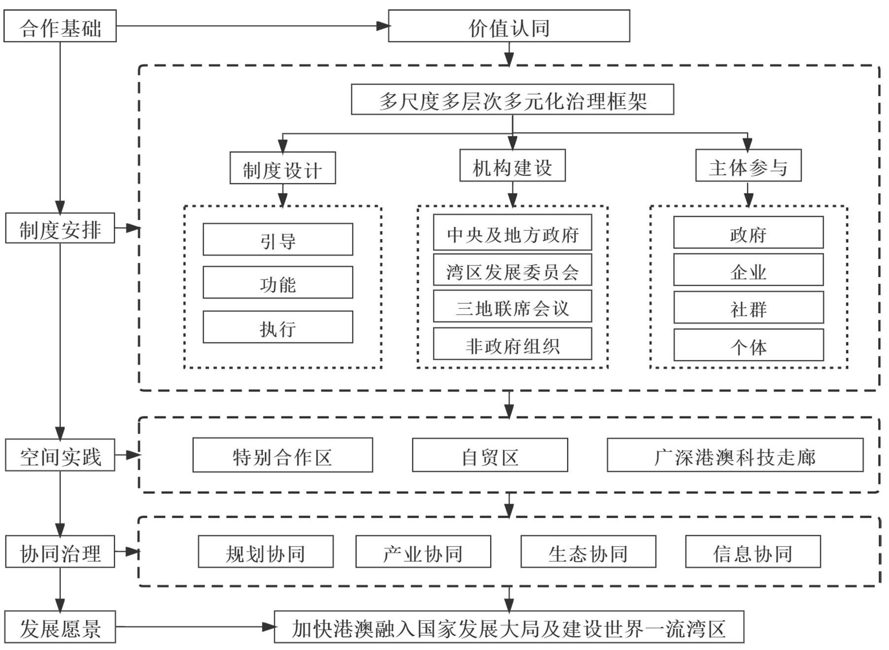
As the Guangdong-Hong Kong-Macao Greater Bay Area has become a national strategy, bay area governance has become an important issue of academic attention. Existing studies pay more attention to specific governance measures and current situation, and there are few studies on the environmental causes behind them. In addition, most of the existing studies focus on the governance of the Greater Bay Area from a single perspective of politics, law, economy, culture and society, and lack of a more comprehensive institutional environment perspective to summarize the theoretical explanation of the political, legal and participant issues that are particularly prominent in the governance of the Greater Bay Area. Therefore, studying the construction of a comparative analysis framework around the institutional environment is aimed to examine the internal causes of the governance characteristics of the Greater Bay Area, enrich the research perspective of domestic regional governance, and provide suggestions for the governance of the Greater Bay Area. This paper constructs a comparative research framework of bay area governance institutional environment, including three dimensions of power structure, legal structure and social capital structure. Using the text/desktop analysis method, it systematically summarizes the governance frameworks of the Greater Bay Area, San Francisco Bay Area and Tokyo Bay Area, and comparatively analyzes the governance institutional environment of the three bay areas. The study holds that the mode characteristics and effects of bay area governance are closely related to the institutional environment composed of power structure, legal structure and social capital structure. The power structure affects the flexibility of governance, and the power structure of the Greater Bay Area is asymmetric and fragmented, which is relatively closed and centralized, resulting in a single governance model always dominated by the government; the legal structure affects the transaction cost of governance, and the Greater Bay Area has not yet formed a unified and efficient legal system structure, resulting in higher transaction cost in the governance process; and the social capital structure affects the multiple participation in governance and the cohesion of the bay area, and in the Greater Bay Area, the positive social capital is relatively weak, the multiple participation in governance is insufficient and the bottom-up cohesion is not strong. Finally, it is suggested that the governance of the Greater Bay Area should start from the power, law and social capital structure, and explore the flexible reconstruction of the institutional space under the respective advantages of the three regions; in the construction of institutional environment, non-governmental subjects should be guided to participate in governance stably and orderly, so as to enhance the cohesion of the Greater Bay Area; and on the basis of ensuring the authoritative policies of the central and provincial governments, it should explore the decentralization and autonomy of local governments in the Greater Bay Area in due course. This paper constructs an institutional environment including power structure, legal structure and social capital structure, and comparatively analyzed the governance characteristics of the three bay areas under different institutional environments. From a more comprehensive perspective of environmental internal factors, it makes a theoretical explanation of the particularly prominent issues of politics, legal system and participants in the governance of the Greater Bay Area, which enriches the research perspective of regional governance in China.
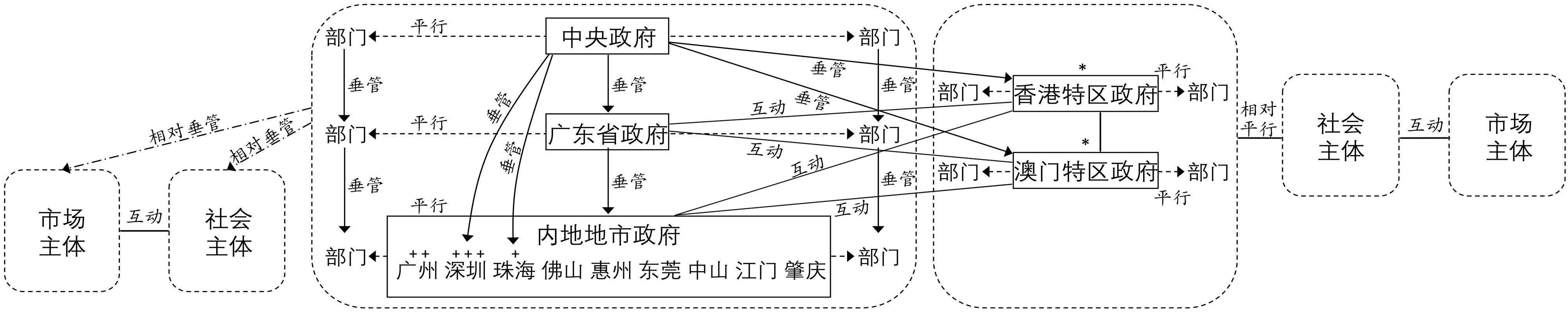
Public policy is an important support for the coordinated development of urban agglomeration. Since the construction of the Guangdong-Hong Kong-Macao Greater Bay Area has become a national strategy, a series of policies aimed at deepening regional cooperation and promoting regional coordinated development have been introduced. The quantitative measurement of policy can finely reflect the internal relationship structure of urban agglomeration governance. This study collected 428 regional coordinated development policies from the websites of the Guangdong-Hong Kong-Macao Greater Bay Area Leading Group Office and the relevant municipal governments. It topologized the relationship between policy subjects, measured the supply intensity of coordinated development policies, and analyzed the spatial connection based on policy relevance. The study found that: 1) The policy measures of one-way benefiting Hong Kong and Macao are the main policy supply direction at present, and in most cases, the policy feedback from Hong Kong and Macao is less than expected. 2) Policy supply is highly concentrated in the field of public services and industrial development, aiming to narrow the service gap between Hong Kong, Macao and the Mainland and attract high quality talents. 3) Districts and counties and local professional departments have not yet fully entered the coordinated development policy network of the Greater Bay Area, due to the lack of consultation platforms matching with their administrative levels. 4) The four central cities of Hong Kong, Macao, Guangzhou and Shenzhen have different policy relations and spatial connections with other subjects in the Greater Bay Area. It is worth noting that although Zhuhai is not regarded as one of the central cities in the Greater Bay Area, it takes the initiative to establish close policy cooperation with Macao and actively seeks to establish partnerships with Guangzhou, Shenzhen, Hong Kong. And these initiatives have enhanced Zhuhai's embeddedness and influence in the regional relationship network. 5) The policy linkages between cities in the Greater Bay Area are frequently interacted within the metropolitan area, and the policy linkages across metropolitan areas are relatively loose. Therefore, this paper suggests that the Guangdong-Hong Kong-Macao Greater Bay Area can further strengthen the two-way policy linkage between neighboring cities, neighboring districts and counties, professional departments and the two central cities of Guangzhou and Shenzhen, coordinate the policies towards Hong Kong and Macao, and make the policy supply further adapt to the governance structure of the Greater Bay Area. In short, this paper explores a method to measure and study the spatial connection of urban agglomeration based on coordinated development policies, which provides a research path for quantitatively indicating the correlation strength of coordinated development policies and the internal relationship structure of regional governance of urban agglomeration, provides technical support for policy formulation and optimization, and supports the fine governance of urban agglomeration.
Economic globalization and regional integration are the core motivations of regional cooperation in the 21st century, and the issue of cross-border cooperation has attracted much academic attention. As the largest regional integration organization with the highest level in the world, EU takes the lead in practicing regional integration in the process of economic globalization. Europe's cross-border governance has been paid attention in a long time in economic geography and political geography, and a large number of theoretical and empirical research results have been achieved on issues such as border cooperation model and cross-border governance mechanism. The development experience of EU provides rich theoretical and practical experience for the collaborative governance in the Guangdong-Hong Kong-Macao Greater Bay Area, as the two also involve the collaboration across institutional boundaries and power restructuring. Therefore, the analysis of EU cross-border cooperation is of great significance to promote Guangdong-Hong Kong-Macao coordination. Based on the bibliometric analysis of Citespace, this paper systematically studies the research trends of EU cross-border cooperation from 1993 to 2020. The study finds that: 1) EU cross-border cooperation research mainly focuses on border regional interaction, cross-border cooperation mode, cross-border cooperation field, cross-border cooperation barriers and other issues. The regional integration of Europe has promoted the transformation of border areas from marginal areas to the forefront of development, and gradually formed a cross-border governance model under the superposition of formal institutional arrangements and informal institutional arrangements. The field of cooperation involves economic cooperation, tourism, environmental governance, health and other fields. 2) The development of EU cross-border cooperation benefits from the political interaction and mutual trust between countries, formal and informal institutional coordination, and the expansion and deepening of the scope of cooperation. However, there are still deficiencies in bilateral differences, cross-border accessibility, immigration and security. 3) As the same cross-institutional border region, the practical experience of EU cross-border cooperation has important enlightenment for the collaborative governance in the Guangdong-Hong Kong-Macao Greater Bay Area. Value identity is the basis of cross-institutional cooperation in the Guangdong-Hong Kong-Macao Greater Bay Area. Inclusive and orderly institutional arrangements are conducive to reducing the shielding effect of cooperation boundaries. And the combination of multi-scale cooperation and multi-dimensional governance system will effectively improve the cooperation in border areas.
Since the 1990s, with the region becoming an important space for governance, people have become more and more aware of the importance and urgency of environmental coordination and promoting sustainable development on the regional scale. Different from the traditional environmental governance model, which regards administrative divisions as boundaries, regional environmental governance actively responds to regional environmental changes across administrative divisions, adapts to the new requirements of regional sustainable development, and effectively complements environmental governance on local, national and global scales. Therefore, a growing attention has been paid on the regional environmental governance research in the West. Since the 40 years of reform and opening-up, the economy and society have developed rapidly in China, especially in the eastern region, which puts forward higher requirements for regional environment and its governance. However, domestic geography research pays insufficient attention to regional environmental governance. This article systematically combs the research progress and frontier issues of western regional environmental governance, in order to promote the research of regional environmental governance in China and provide a conceptual framework for the research of environmental governance in the Guangdong-Hong Kong-Macao Greater Bay Area. Firstly, it analyzes the concept, importance and challenges of regional environmental governance, explains what regional environmental governance is, and focuses on the complementary relationship between regional environmental governance and local, national and global environmental governance. Then it analyzes the development progress of regional environmental governance theory, and expounds the regional environmental governance model and impact effect. Based on the above research progress, it is considered that the research on environmental governance in the Guangdong-Hong Kong-Macao Greater Bay Area should focus on the following four aspects: (1) The organizational framework under the "one country, two systems" policy with Chinese characteristics that leads the formulation and implementation of regional environmental policies and coordinates different stakeholders; (2) The geographical factors for intergovernmental cooperative environmental governance and jointly implementation of environmental strategies in the Guangdong-Hong Kong-Macao Great Bay Area led by the government under the background of urbanization and globalization, which are different from western countries under the influence of strong non-governmental organizations; (3) The potential impact of the implementation of regional environmental governance on China's current economic transformation and development and spatial reconstruction;. (4) The institutional arrangements that are conducive to the balanced development of economic development and environmental protection and can promote regional sustainable development. The research on regional environmental governance will help to expand the research on domestic regional environmental governance, and has important practical significance for understanding the contradiction between economic development and environmental protection and exploring sustainable development policies since the in-depth development of the Guangdong-Hong Kong-Macao Greater Bay Area and even China.
Since the 21st century, the term "scene" has been widely used in various fields, mainly involving sociology, communication, education, the Internet, commercial marketing and so on. Academic circles have also carried out scene-related research to form their own definitions and theories. With the continuous innovation of technical means, the connotation of a scene is constantly enriched, from the face-to-face physical space dimension to the multi-dimensional information space, and gradually evolved into the scene characteristics of spatio-temporal integration. However, there is still a lack of complete theoretical research and practical discussion on what is the scene, what are the elements of the scene, and how to combine the specific scene to guide and carry out the scene planning and design in different fields. The existing scene theory cannot be well applied in the field of urban development, and cannot help the scene related research of coordinated development of urban agglomeration. By combing the development context of scene theory at home and abroad, this study makes an in-depth interpretation and analysis of the connotation and characteristics of the scene. It is believed that the scene contains six characteristic elements, such as time, space, object, problem, path and value. The scene is a kind of specific interactive relationship formed by a series of actions, based on the key issues and objectives of the events under specific spatio-temporal conditions, with technology and resources as the media. The construction of the scene can meet the needs of stakeholders and create and realize value. The theoretical system of scene planning including scene elements, scene hierarchy characteristics and scene planning methods is constructed. It is considered that scene planning is a systematic process to realize specific social, economic or ecological functions and values by integrating existing resources and technologies to carry out scene construction and design, focusing on key issues and objectives with stakeholders as its center, under the environmental factors of social and economic development, government policies and technological innovation. From the perspectives of scene recognition, scene construction, scene evaluation and scene application, the new exploration of scene planning tools is realized to guide scene practice in different fields. Taking the coordinated development of urban agglomeration in the Guangdong-Hong Kong-Macao Greater Bay Area as an example, this study excavates the current problems and development objectives of the Greater Bay Area based on the scene planning method, identifies 100 important scene units representing the coordinated development direction of urban agglomeration in the Greater Bay Area, and identifies and analyzes each scene element for these scene units, so as to provide basic support for further scene construction. Finally, taking the ecological corridor construction of urban agglomeration in the Guangdong-Hong Kong-Macao Greater Bay Area as an application example, the scene planning method is preliminarily applied to analyze the scene elements, so as to provide a basis for the next practical exploration work such as scene evaluation and scene application demonstration. The theoretical system of scene planning is not only a further extension of the scene concept, but also an overall coordination tool to promote the coordinated development of urban agglomeration. It can provide theoretical basis and practical guidance for the future scene research on the coordinated development of urban agglomeration, and help the collaborative construction of urban agglomeration. In the future, it is suggested to carry out specific scene analysis and scene design on the industry, population, transportation, environment, infrastructure and public services of the GBA urban agglomeration, and gradually realize the in-depth exploration of the coordinated development theory and mechanism innovation of the Guangdong-Hong Kong-Macao Greater Bay Area through the scene planning theory.
A typical urbanized area in the Guangdong-Hong Kong-Macao Greater Bay Area, Liuxi River-West Channel-North Channel in Guangzhou City, was used to reveal the impacts of rapid urbanization on riverine nutrients. Two field campaigns were implemented in both wet and dry season, e.g. July 2020 and January 2021. Forty surface water samples were collected to analyze indicators such as major ions and stable isotopes (δ15N-
The "Water-energy-food" nexus is an important content in the field of ecosystem security. Constructing and optimizing the ecological security pattern from this perspective is of great significance to alleviate the contradiction between social production and ecosystem and improve people's well-being. With the rapid economic development in the Guangdong-Hong Kong-Macao Greater Bay Area, the contradiction between supply and demand of water, energy and food resources is prominent. This study evaluates the ecosystem services in the Greater Bay Area from the three dimensions of "water-energy-food", modifies the ecological resistance surface by using Luo Jia No.1 luminous data, and constructs and optimizes the ecological security pattern of the Greater Bay Area by using the minimum cumulative resistance model. The findings are as follows: (1) The total area of ecological source in the Greater Bay Area is 9,626.1 km2, mainly distributed in the mountainous and hilly areas in the east and west of the study area, corresponding to Jiangmen City, the middle of Huizhou City and Zhaoqing City, with an average altitude of over 1,000 m above sea level and relatively high terrain, dominated by woodlands. (2) There are 38 ecological corridors in total, with a total length of 2,023.09 km, of which the shortest is 11.76 km and the longest is 304.99 km. They are concentrated in the mountainous and hilly areas with good vegetation coverage, and there are no corridors in the middle. (3) The radiation area of ecological source is 28,929.5 km2, accounting for 51.88% of the total area of the Greater Bay Area. The western part of the study area is almost completely covered, with more areas remaining uncovered in the east. In order to achieve 60% coverage, it is necessary to add a minimum of 4,524.856km2 of ecological source radiation area in both the northern and southern parts of Huizhou. (4) Based on the distribution of the "water-energy-food" nexus in different regions, it is proposed to construct an ecological security pattern optimization model with "one belt, one axis and four clusters" as the core which could provide scientific references for regional ecological space development from the perspective of "water-energy-food".