The travel efficiency of public transportation is a key indicator for judging whether the quality of public transportation has developed compared with other modes of transportation, especially private vehicles. The quality of public transportation is also an important reference factor for residents' choices. With the rapid urban expansion and improvement in motorized travel levels, reducing the time difference between private vehicles and public transportation is the key to improving the attractiveness of public transportation. The relative spatiotemporal efficiency is based on the time difference between private vehicles and public transportation, considering the number of passengers. Recently, scholars have shown great interest in relative travel efficiency. However, relevant studies have shown poor real-time performance because of the unavailability of large datasets, which cannot dynamically reflect the characteristics of relative travel efficiency. The spread of big data and internet maps enables us to perform systematic efficiency evaluations. The internet map incorporates various travel-related information such as travel route, time, and cost under different travel modes based on real-time road conditions and provides access to the extracted embedded travel information. This study proposes a framework for evaluating the spatiotemporal efficiency of different travel modes based on real-time road conditions in Shenzhen. First, travel time data were obtained using an internet map during the morning, afternoon, and evening rush hours. The passenger flow volume was computed using smart card data. We then constructed an evaluation index model of spatiotemporal efficiency based on the relative time efficiency and weighted passenger flow volume. Finally, the results highlighted the following: 1) the relative time efficiency of public transportation was higher during the evening rush hours than in the morning. The main reason was the increase in private vehicle travel time during the evening rush hours, reflecting the complexity of urban road conditions during the evening; 2) the spatiotemporal efficiency index of central public transport stations fluctuated greatly during the three periods, which was closely related to the dynamics of traffic volume caused by the high concentration of workplaces; 3) the spatiotemporal efficiency index of public transportation stations exhibited spatial aggregation characteristics in the three periods, highlighting the different clustering characteristics in the central and outer areas; 4) the spatiotemporal efficiency index of subway stations was generally higher than that of bus stations, reflecting the importance of subway systems in urban transportation networks. Evaluating the relative travel efficiency of urban public transport contributes to analyzing the development status of public transportation, supporting decisions to achieve high-quality development of public transport, and providing travel information for the government and residents.
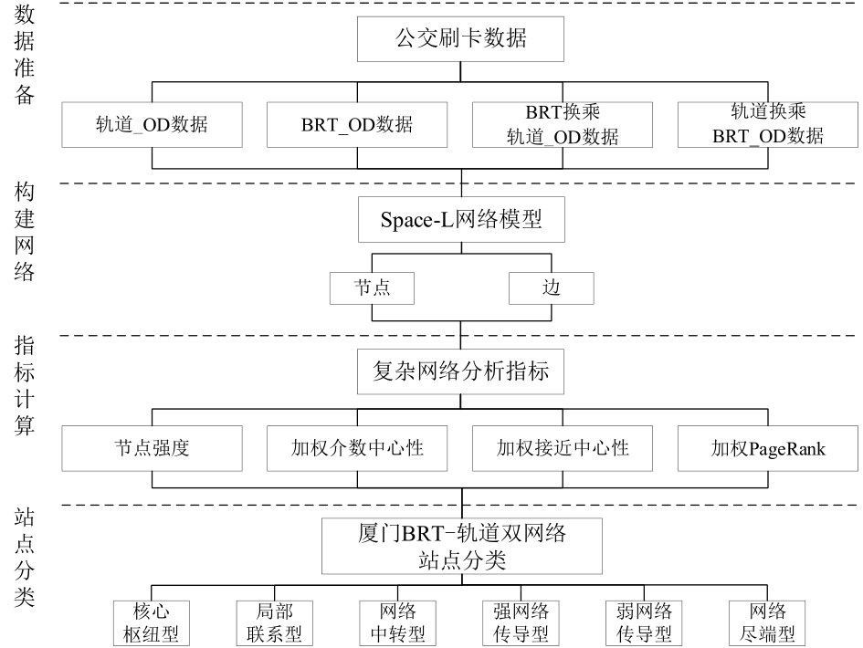
Mass traffic stations are key nodes in integrated traffic networks. The scientific definition of station types is of great significance for the refined management of stations and network operations. Using the Xiamen BRT track double-mode network system as the research object, this study analyzed the characteristics and hierarchical relationships of the station network and used complex network analysis to classify stations within the network. By constructing a Space-L-directed weighted complex network model based on station passenger flows, this study proposes four indicators: node strength, weighted betweenness centrality, weighted closeness centrality, and weighted PageRank. A system-clustering method was used to classify the stations. The results are as follows: (1) In the complex network model, the network sites can be divided into six types: core-hub type, local connection, network transition, strong network conduction, weak network conduction, and network-end. The important sites of the network are gathered at the center of Xiamin island, and the secondary sites of the network are distributed on the periphery of the regular spatial network. The important sites of the network outside the island are distributed in mature urban construction areas, and the secondary sites are scattered in preliminary urban construction development areas. (2) All transfer station types have different characteristics. Single-mode transfer stations have the ability to adjust network passenger flow and accommodate the transfer capacity of passenger flow between various regions of the city, whereas double-mode transfer stations have the ability to attract network passenger flow, and the station and other stations on the network. It is closely connected and has high accessibility; single-mode and double-mode combined transfer stations have the ability to promote network passenger flow, and have high passenger flow connection strength and global passenger flow influence ability. (3) Among the single-mode stations in the BRT-metro transit network, the BRT stations perform better than the metro stations. This feature is more obvious in the island area owing to the unbalanced development of the east and west areas of the island. The station classification index and method proposed in this study can reveal the characteristics of station networks, which can improve the operational efficiency of urban BRT-rail network systems.
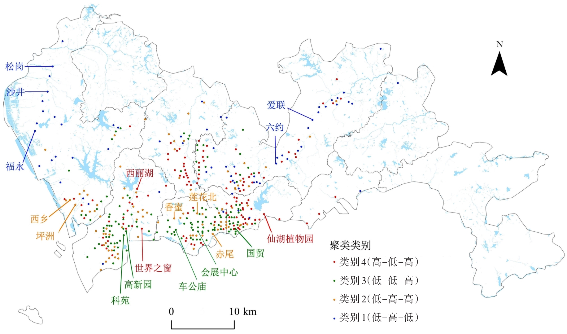
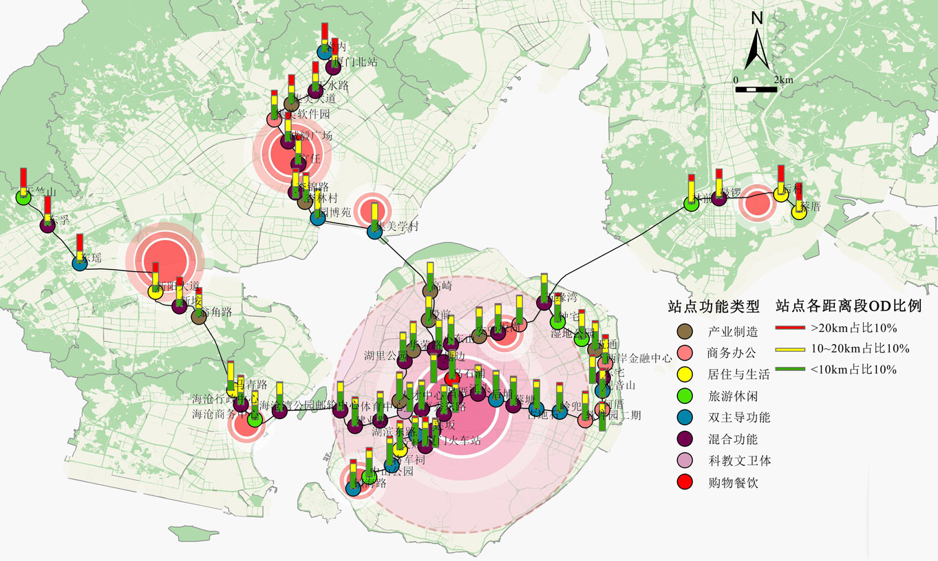
The comprehensive development of rail stations combining the Transit Oriented Development (TOD) concept with rail transit has been a research and practical hotspot in recent years. The functional layout within the station catchment area and between rail stations is an important basis for implementing TOD to guide the optimization of urban spatial structures, and passenger flow is a direct reflection of its functional layout effectiveness. Studying the adaptability of rail station functions through passenger flow characteristics has important practical significance for the comprehensive development of rail transit as the main body and for promoting the optimization of urban spatial structures. However, in existing research, there has been no unified conclusion on the mixed and differentiated functional layout of the station catchment area, which has often been advocated for the differentiation of functionality between stations, however, it mostly remains at the guiding ideology level. Therefore, this study categorized and assigned weights to the POI in the station catchment area and divided the Xiamen rail stations into three categories: stations with single dominant functions, stations with dual dominant functions, and stations with mixed functions. The relationship between the functional layout of stations and their corresponding spatial passenger flow was analyzed based on the OD volume of passenger flow between different functional types of stations and the distribution of OD in different distance segments. Based on the current functional layout characteristics and corresponding passenger flow characteristics of rail stations, further optimization strategies are proposed. The results show that: 1) Stations with high passenger flow are mostly those with single and dual-dominant functions, and the passenger flow of stations with mixed functions is not prominent; high-passenger flow stations are mostly those with high-level central functions, mainly distributed in urban central areas; and low-passenger flow stations are spatially concentrated, mostly concentrated near the end of the line. 2) The functional complementarities between spatial stations directly affect passenger flow OD volume, and the OD volume between stations of the same type is small. Meanwhile, that between stations of different types is large. 3) The OD ratio of each distance segment of the station is affected by the functional grade of the center and functional complementarity of the surrounding stations. The proportion of short-distance OD at stations in the central urban area is relatively large, whereas the proportion of long-distance OD at stations near the end of the line is relatively large. Finally, the causes of the current rail station functions and corresponding passenger flow characteristics were analyzed based on the internal logic of the occurrence and attraction of passenger trips with urban functions, central place theory, and the market rules of urban functional layout. Based on the requirements of urban spatial structure, the principle of comprehensive development function layout for rail stations is proposed, which includes "mixed basic functions, concentrated dominant functions" in the station influence area and "complementary differences, connecting points and forming axes" between stations.
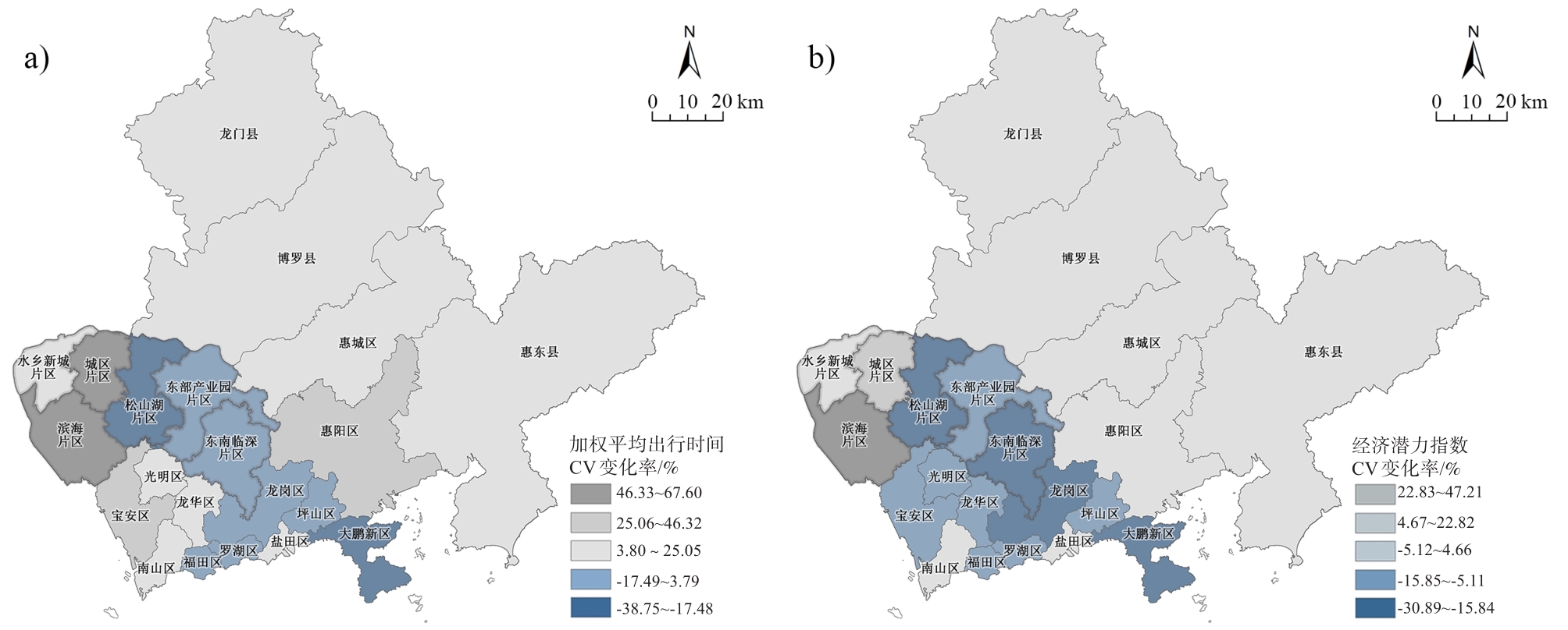
Intercity rail planning and construction generates improved regional accessibility and contributes to changes in the spatial organization of the region, incorporating more areas into the 'integrated corridor economy' through the increased attractiveness of new connection locations in a dynamic process involving multi-level impacts in social and economic domains. In addition, the development of areas outside the intercity rail corridor could also be altered by new intercity rail plans; these improvements, often referred to as efficiency impacts, are mainly related to accessibility benefits. Traditional assessment methods do not address the conflicts between efficiency and equity concerns. Achieving a single efficiency objective would bias intercity rail planning towards providing efficient connections between major centers of economic activity, negatively impacting spatial equity as it would lead to polarized spatial development patterns. Equity considerations are receiving increasing attention in current regional transport planning studies, in which intercity rail planning needs to maximize economic growth while maintaining an acceptable level of equity. We divided the scenarios based on different stages of intercity railway planning and construction, built the model of spatial equity and efficiency, adopted weighted average travel time, potential accessibility, and coefficient of variation as evaluation indexes, and conducted an empirical analysis of the changes in spatial equity and efficiency in the Shenzhen-Dongguan-Huizhou region under the scenarios of no intercity railway, current intercity railway, and planned intercity railway, to discuss the development of an equitable and efficient regional spatial model through intercity railway planning and construction. The findings indicate that: Firstly, the planning of intercity railways in Shenzhen-Dongguan-Huizhou region effectively promotes the overall improvement of accessibility, and the economic development potential of the areas along the routes is much higher than that of areas not located along the routes. Secondly, the core growth poles of Shenzhen-Dongguan-Huizhou region continue to be reinforced, and the planning of intercity railways significantly increases the economic radiation capacity of Shenzhen; however, the imbalance of regional development increases concurrently. Thirdly, the spatial equity layout of the Shenzhen-Dongguan-Huizhou region is characterized by a high level in the central and western areas and a low level in the two wings under the influence of the intercity railway plan, with the western coastal area of Dongguan and the northeastern part of Huizhou gaining inferior benefits. Lastly, the intercity railway plan has led to a more balanced pattern of economic linkages in the Shenzhen-Dongguan-Huizhou region, with a greater enhancement of spatial equity in areas close to Shenzhen. In general, the difference in the accessibility of the intercity railways in the Shenzhen-Dongguan-Huizhou region is significantly associated with factors related to the direct connection with the intercity railways and the location in contact with the core areas. The time-space compression effect produced by the construction of intercity railways has led to the expansion of the radiation range of the regional hinterland of the Shenzhen-Dongguan-Huizhou region, thus achieving optimal regional spatial distribution. In addition to enhancing the economic benefits of the transport network, the Shenzhen-Dongguan-Huizhou region should also take into account the equity of resource allocation and promote sustainable optimization as well as a balanced development of the spatial structure.
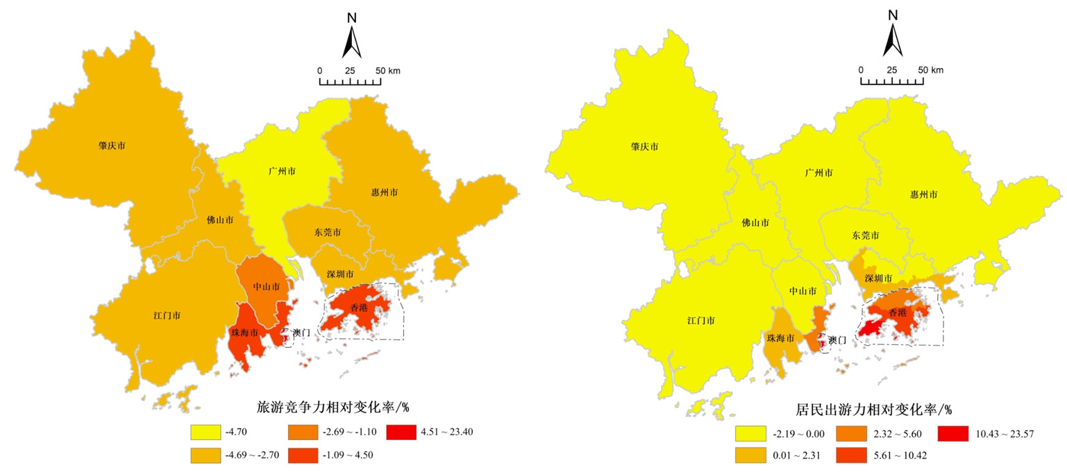
The completion of the Hong Kong-Zhuhai-Macao Bridge makes the Guangdong-Hong Kong-Macao Bay Area a closed-loop traffic system that provides the basis and possibility for tourism integration. From the spatial perspective of tourism supply and demand, this study examines the pattern of tourism competitiveness and residents' travel potential of cities in the Bay Area before and after the opening of the bridge, using the Geographic Information System and an improved gravity model of the tourism system. The development trend of regional tourism integration under bridge impact was also analyzed. The results show that: (1) the opening of the Hong Kong-Zhuhai-Macao Bridge has facilitated a more balanced distribution of tourist flows on the east and west sides of the Pearl River Estuary, which will benefit balanced development and promote the integrated development of regional tourism in the Guangdong-Hong Kong-Macao Greater Bay Area. (2) The bridge impact index on tourism competitiveness and residents' travel potential in 11 cities in the Greater Bay Area was significantly correlated with traffic accessibility change following the opening of the bridge, presenting an obvious attenuation effect of the bridge's impact on tourism with distance to the bridge. The opening of the bridge has reduced tourism resistance between the two sides of the estuary and greatly strengthened tourism cooperation between cities on both sides of the estuary, especially the complementary resource advantages between the east and west bank city clusters (Hong Kong, Shenzhen, Macao, and Zhuhai). (3) The impact on tourism competitiveness and residents' travel potential in the Greater Bay Area shows a significant spatial clustering pattern. The high-value clustering areas are mainly located in Hong Kong, Macao, and Zhuhai, which are directly connected by the bridge. Some areas of Zhongshan and Zhuhai are surrounded by high-value neighbors and are more likely to be diffused. Some areas of Guangzhou-Foshan and Shenzhen-Dongguan are low-value clustering areas, showing a marginalization trend. The bridge significantly strengthens the advantages of the core city agglomerations of Hong Kong and Macao. The relative status of Guangzhou and nearby areas has been weakened; however, the bridge does not affect Guangzhou's leading position in the tourism industry in the Guangdong-Hong Kong-Macao Greater Bay Area.
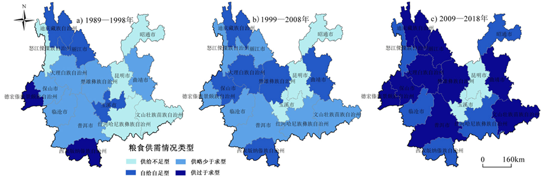
As the new crown epidemic ravaged the world, China's grain production has been greatly impacted and challenged. Studying the current situation of grain production in Yunnan Province is of great guiding significance for its future grain production structure adjustment and optimization layout. In this study, the spatiotemporal changes in grain production in This paper mainly uses the logarithmic method to calculate the contribution rate of the influencing factors, the decomposition and calculation method of the contributing factors of the change of grain total output, the gravity shift model and the grain yield volatility coefficient to analyze the spatio-temporal changes of grain production in Yunnan Province.Through the analysis of data, the following results were obtained: (1) In the past 30 years, the grain planting area and yield in Yunnan Province have shown a significant upward trend. In particular, the total output growth rate has reached 97% and the increase in the single yield of each crop and adjustment of the planting structure are the main contributors to the increase in the total grain output of the province. The planting area of rice and wheat has decreased by 16% and 36%, respectively, over 30 years, and the total and single yields have not changed substantially. The growth rate of the planting area, total yield, and single yield of maize is most obvious. The changes in the total yield of potatoes during the study period were all caused by changes in planting area, with contribution rates of 85%, 78%, and 206%, respectively, in the three periods. (2) The grain planting area and output in Yunnan Province generally show the distribution law of more east and less west. The most abundant area is Qujing City and the least is the Diqing Tibetan Autonomous Prefecture. The center of gravity of grain production has a tendency to migrate to the northeast. Rice production is decreasing from southeast to northwest, and the high-value areas of wheat yield are gathered from all sides to the middle. Corn production is the fastest, and potato high-yield areas are mainly distributed in northeast Yunnan. (3) In the past 30 years, the per capita grain in Yunnan Province has increased by 111.56 kg/person, and the grain production capacity has improved and is currently of the self-sufficient type. However, the fluctuation coefficient of more than 70% of the years exceeds the national average, grain supply is relatively unstable, and contradiction between grain supply and demand remains prominent. It is concluded that the grain planting area and yield in Yunnan Province have gradually increased, the current situation of grain production is mainly self-sufficient, and the differences between the main grain crop-producing areas are quite large, and it is extremely important to pay attention to the optimization of the grain planting structure and promote the stable increase of grain production. At the same time, according to the analysis results, this study proposes that the main problems of grain production in Yunnan Province are (1) the decline in the amount of cultivated land; (2) the high number of medium and low yield fields; and (3) the phenomenon of "non-grainization" is more serious. In the face of the development status of grain production in Yunnan Province, relevant departments still need to pay attention to the quantity and quality of cultivated land, adjust the agricultural planting structure, and comprehensively improve grain production capacity in the future. It is necessary to (1) increase subsidy policies and adhere to the red line of cultivated land; (2) invest in relevant technologies to increase grain yields; and (3) coordinate the process of urbanization development and adjust the planting structure according to local conditions. This study investigated the spatiotemporal changes in major crop production in Yunnan Province over the past 30 years; obtained corresponding conclusions on timing changes, spatial distribution, and contributing factors; analyzed the current grain production security situation in Yunnan Province; summarized the main problems in its development process; and put forward targeted suggestions, so as to further develop a deeper understanding of the current situation of grain production in Yunnan Province to play a certain guiding and reference role in its future development and planning direction.
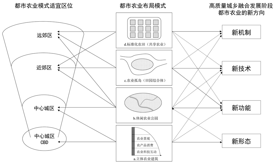
This research investigated the new concept of urban agriculture in the new stage and its patterns based on four practical cases of urban agriculture in Guangzhou: Huacheng Farm Park in Tianhe, Happy Farmland in Haizhu, an urban Jintian in Huangpu, and Amy's Rice Town in Conghua. The results show the following: First, after experiencing the four stages of the independent stage in the urban-rural isolation period, output stage in the rural-support urban period, compensatory stage in the urban-feeding rural period, and modern agriculture stage in the urban-rural integration period, the new stage of urban-rural, high-quality integrated urban agriculture indicates the four new characteristics of new functions, new technologies, new mechanisms, and new forms. Second, based on the concepts of the four new characteristics of urban agriculture in the new stage, the development of urban agriculture in Guangzhou can be summarized by the four basic patterns of stereoscopic agriculture (new form), leisure agriculture (new function), rural complex (new technology), and shared agriculture (new mechanism) distributed from the central to outside region. Stereoscopic agriculture, which is basically located in the CBD, combines agriculture and commercial functions, focusing on new technologies such as e-commerce operations and technological displays, emphasizing the characteristics of commercial operations in the mechanism, and manifesting itself as an intensive three-dimensional construction. Leisure agriculture, essentially located in the urban central area, is the combination of agriculture and the daily recreation function of citizens. It applies park landscape construction and artistic creation techniques, revealing the characteristics of the farming experience and providing leisure parks for citizens. The rural complex is basically located in the inner suburban area and combines agricultural production with scientific research activities. It comprehensively uses new technologies of farmland consolidation and agricultural production and is characterized by science, technology, and agriculture shaped as independent islands. In the outer suburbs, shared agriculture combines traditional agricultural production with the rural tourism experience, in addition to using new agricultural technologies for farmland preparation and production. It also emphasizes using new Internet of Things technologies, highlighting the new mechanism of shared participation, and is designed as standardized farmland. Third, the innovative experience of Guangzhou's urban agriculture development mainly includes strengthening the transformation of agricultural resources and the value of multiple functions; diversified innovation and integration forms; pattern innovation, new technologies, and artificial intelligence to enhance the development of urban agriculture; the combined mechanism of "government, enterprise, and university"; and institutional guarantees to facilitate the implementation of urban agriculture projects. The development of urban agriculture in the new stage of urban-rural integration in Guangzhou provides experience and lessons for other cities.
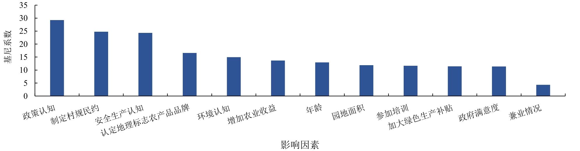
With the acceleration of agricultural modernization, problems such as agricultural nonpoint source pollution and the proliferation of agricultural carbon emissions have become increasingly prominent. In this context, promoting sustainable agricultural development; ensuring national food, resource, and ecological security, and accelerating high-quality agricultural development have become inevitable trends. Promoting the green development of agriculture is one of the core tasks of high-quality agricultural development, and the implementation of green production behavior is the key to promoting the green transformation of agriculture. Farmers are not only the main bodies of agricultural production, but also the main implementers of green production. Therefore, it is of great practical significance to clarify the factors influencing farmers' green production behavior and the relative importance of each influencing factor. Based on the perspective of the entire industry chain and survey data of 360 lychee growers in major lychee-producing areas of Guangzhou City from May to August 2022, this study uses an ordered logistic regression model to explore and analyze the influencing factors of the green production behavior of lychee growers. The importance of these results is then ranked using the random forest model. The organic combination of these two methods overcomes the limitations of a single statistical method. The results show that 1) the age and part-time employment of lychee growers and the lychee planting area significantly negatively affect the implementation of their green production behavior; 2) production safety, environmental, and policy cognition can effectively promote the adoption of lychee growers' green production behaviors; 3) village rules and regulations, increasing green production subsidies, identifying geographical indication product brands, government satisfaction, participating in training and increasing agricultural income all significantly positively affect the lychee growers' green production behavior; and 4) the relative importance of explanatory variables ranks from high to low as follows: policy cognition, formulating village rules and regulations, production safety cognition, identifying geographical indication product brands, environmental cognition, increasing agricultural income, age, the planting area of lychee, participating in training, increasing green production subsidies, government satisfaction, and part-time employment. The four influencing factors are also ranked in order of importance: cognitive characteristics, external environment, family business characteristics, and personal characteristics. Accordingly, this study suggests that the government should first, based on respecting the subjectivity of lychee growers, formulate relevant policies according to local conditions to stimulate the internal power of their sustainable development, stimulate their consciousness, and improve their responsibility toward green production by increasing green production subsidies by realizing the visualization of income and benefits, building a diversified publicity and training system, and other means. A supervision mechanism should be established to standardize the behavior of lychee growers, and measures such as market supervision, village rules, and regulations should be adopted to constrain them. Finally, governments must create an external environment conducive to green development by appropriately expanding the planting scale to reduce the proportion of part-time lychee growers; building a high-quality brand image; promoting cooperation among research institutes, universities, and lychee growers; and comprehensively improving their green production levels.
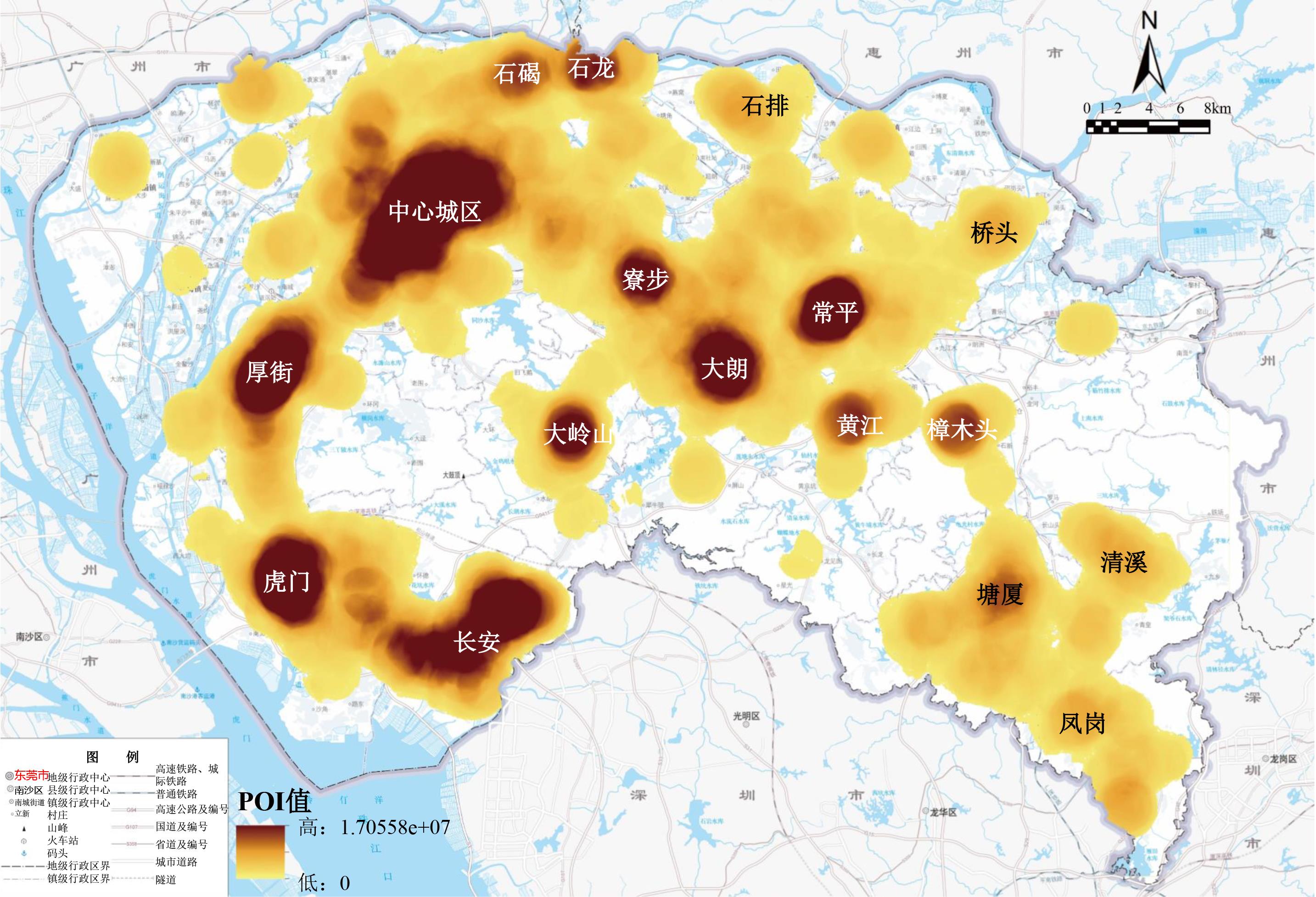
Public center systems planning is of great significance in controlling and guiding the optimization of urban spatial structures, activating the efficiency of urban operations, and improving the quality of urban spaces and human living environments. However, most previous studies used a single data source and focused on identifying the physical space characteristics centered on traditional commercial and public service facilities, making it difficult to accurately measure the actual operational performance of public centers. Therefore, this study relied on multiple data sources to research Dongguan City in South China from multiple perspectives. The formation of Dongguan's central system was affected by two factors: the external force of the megacity region and the endogenous driving force of urban development. First, qualitative and quantitative calibration methods were used to identify the spatial patterns of public centers from the spatial morphological dimension in an all-round and all-temporal manner using Kernel Density Estimation (K) and the Getis-Ord G
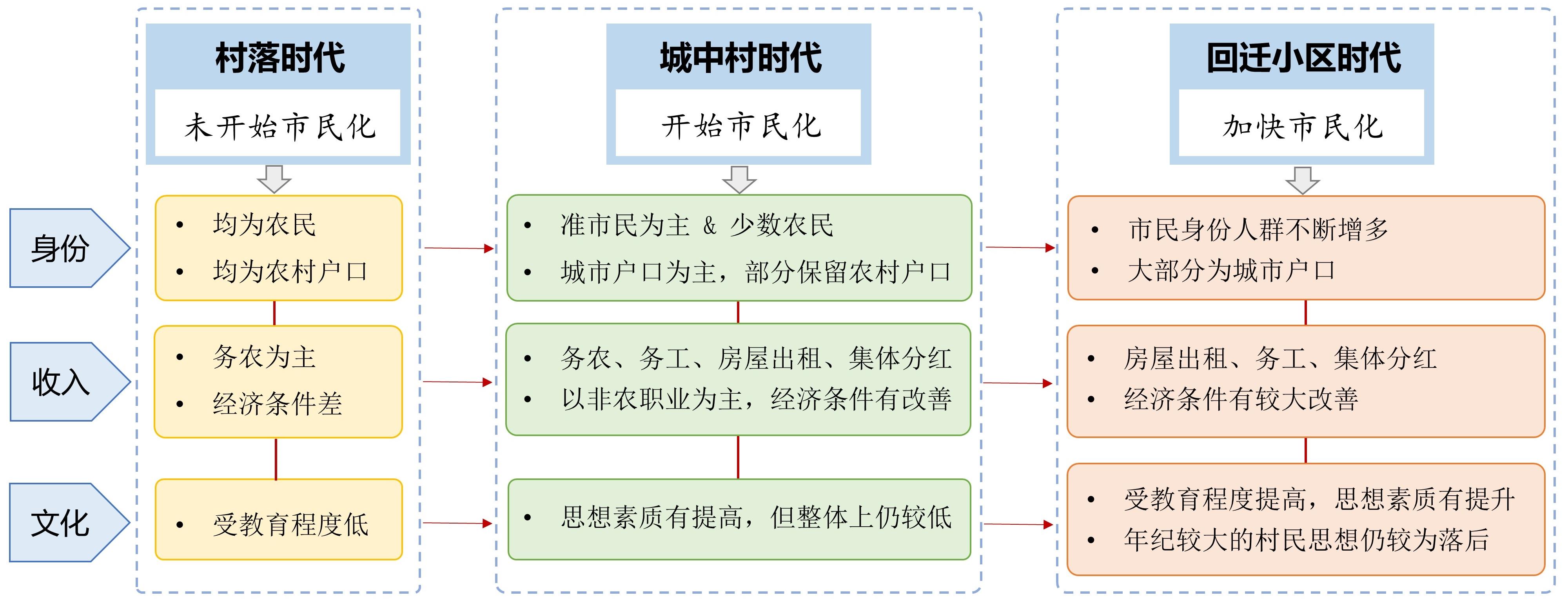
China's new urbanization strategy emphasizes the need to help more people enjoy equal access to urban public services while increasing the urbanization rate. With the implementation of the new urbanization strategy, how the villagers of the original rural settlements surrounded by the urban landscape (i.e., urban villages) turn into citizens (i.e., citizenization) has attracted much attention. However, few studies have attempted to deconstruct the influence of the entire change process in urban villages on the process of villagers' citizenization by associating the fate of villagers with external urbanization. To make up for this research gap, this study took Yangji Village of Guangzhou as an example, using the theoretical framework of citizenization to analyze the process and results of citizenization of villagers from the three perspectives of identity, economy, and cultural citizenization, focusing on discussing the relationship between the changes of Yangji Village and the citizenization of villagers and the lagging problems of citizenization of villagers in urban villages to realize a deep discussion on the phenomenon of identity change of villagers in urban villages and clarify the general characteristics and special process of citizenization of urban villages. The results found that: 1) the basic path of citizenization of villagers in urban villages was that farmers acquire urban household registration and urban employment opportunities in the process of land expropriation by the government and gradually realize citizenization by integrating into the social division of labor; 2) the citizenization process of villagers in urban villages can be roughly divided into three stages: the village period, the urban village period, and community relocation period; 3) the government's land acquisition and housing rental behaviors promoted the transformation of villagers' occupation and cultural psychology, while the urban village reconstruction improved the income of the villagers, enhanced the cultural atmosphere of the community, and further promoted the citizenization process of the villagers' identity, occupation, and culture; 4) the reconstruction of urban villages boosted the citizenization process of villagers on the whole. However, the citizenization of villagers was not only the transformation of living space behind the transformation but also affected by the location of urban villages, village collective cadres, external social environment, individual subjective initiatives, and others. The realization of citizenization requires villagers to have a real sense of citizenship, change their way of life, and discard unreasonable traditional ideas. In this process, the government should establish an effective social security mechanism to help land-lost farmers enjoy the same rights as urban citizens regarding employment, social security, housing, education, and other aspects. In addition, community activities or modern media should help less-educated villagers accept the new culture, improve their ideological quality, realize the institutional and normative nature of urban civilization, and enhance their awareness of public services.
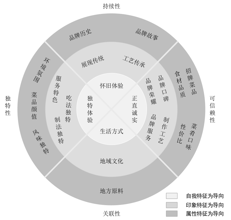
Pertinent evidence clearly shows that food not only meets the basic needs of tourists, but is also an important carrier of the tourist experience. We investigated the type of restaurants that tourists favor. Obtaining tourists' identity from food and beverage brands is crucial. Authenticity has become the standard of purchase as tourists pursue unique cultural experiences. However, research on tourism has paid little attention to brand authenticity. Therefore, this study analyzes the composition of the authenticity dimension of local catering brands in the tourism context and develops a set of reliability and validity scales to explore the impact of brand authenticity on brand identity and word-of-mouth recommendation willingness. Based on brand authenticity theory, this study analyzes the authenticity dimensions of local catering brands. Study 1 found that restaurant brand authenticity can be divided into four dimensions: continuity, credibility, relevance, and originality. Study 2 developed a brand authenticity measurement scale based on the connotation of the four dimensions of brand authenticity combined with interview data and further verified nomological validity. The results showed that the continuity dimension is an important external clue for tourists to identify a brand; however, it does not affect their willingness to recommend it. The relevance dimension favorably affects brand recommendation but does not affect brand identity. This study provides novel insights into the nature of brand authenticity and highlights its importance in branding theory and practice. First, this study developed a brand authenticity scale for food and beverage brands in the context of tourism based on theories of brand authenticity. The authentic content of the brand from a tourist perspective is crucial for tourism management departments and industries. Second, the tourism context provides tourists with a social environment that is substantially different from that of daily life. The travel world, characterized by temporary and off-site characteristics, encourages tourists to pay more attention to brand continuity, credibility, relevance, and originality. In addition, this study confirms that brand authenticity favorably affects brand identity and the willingness to recommend via word-of-mouth. Further analysis showed that the continuity dimension is an important external clue for tourists to recognize the brand; while it does not affect their willingness to recommend, it promotes brand recommendation, but it does not affect brand identity. This study used quantitative research to confirm the relationship between brand authenticity, brand identity, and word-of-mouth recommendations. The results of this study have several practical implications. Therefore, we should aim for the brand's target market, pay attention to how tourists in the target market define the authenticity of the brand and the relationship between lifestyle and the brand, and establish an effective marketing strategy. Specifically, the brand's continuity, credibility, relevance, and originality were further enhanced in four dimensions. In addition, the brand authenticity scale in the tourism context can be used to measure and compare the differences in brand authenticity of different types of restaurants and can create brand authenticity rankings to guide tourists' consumption.
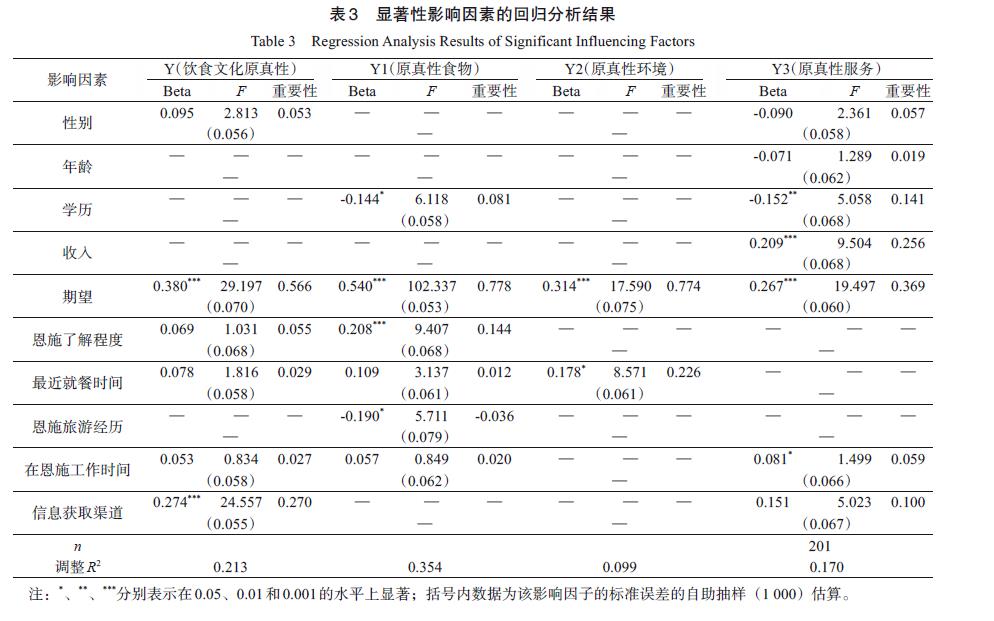
With expanding globalization and the "cultural turn" in geographic research, the mobile phenomenon of the trans-local production of food culture has received increasing attention from society and academia. Trans-local ethnic theme restaurants are important carriers of food culture, and customer perception has always been a research hotspot for catering enterprises. However, there are few studies on the differences in customer perceptions of the authenticity of trans-local ethnic theme restaurants and the factors affecting them in multi-ethnic countries. To explore the differences in customer perceptions and influencing factors of the originality of food culture in trans-local ethnic minority theme restaurants, this study employed the theoretical framework of the originality of food culture, taking the Enshi Tujia restaurant in Wuhan as the research object, combining online text information and questionnaire surveys, and applying the Exploratory Factor Analysis (EFA) and Confirmatory Factor Analysis (CFA) methods to validate the theoretical framework of the originality of food culture in trans-local ethnic minority theme restaurants. Moerover, it used the Potential Conflict Index (PCI) method to analyze the overall level and internal differences of customers' perceptions regarding originality of trans-local ethnic minority food cultures. Specific factors affecting the differences in customers' perceptions were explored using the one-way nonparametric test and the optimal scale regression analysis. The results of the study are as follows: (1) The customers' perception levels of food and environmental authenticity in the Enshi Tujia restaurant in Wuhan were 0.60, but the customers' perception level of service authenticity was -0.06. The PCI values of food and environmental authenticity were 0.09 and 0.08, respectively, but the PCI values of service authenticity was 0.35. (2) Significant factors contributing to the differences in customers' perceptions of the originality of the dietary culture, such as expectations and information access, were: the overall level and internal differences in customer perceptions of food culture were not significant. Significant factors of customer perception differences, with importance indexes of 0.566 and 0.270, respectively, were found. Education was a significant factor leading to customer perception differences in food and service authenticity, with importance indexes of 0.081 and 0.141, respectively. Stimuli such as the degree of understanding of Enshi and the experience of traveling there lead to significant differences in the perception of food authenticity, with importance indexes of 0.144 and 0136. Recent dining time and income indicated that customers' perception of environmental authenticity and service authenticity differ significantly, with importance indices of 0.178 and 0.256, respectively, whereas cultural background factors such as the place of origin did not have a significant impact on the difference in customers' perceptions of the food culture authenticity. The study conclusions as follows: (1) Customers' perception of food authenticity and environmental authenticity of ethnic minority themed restaurants was high with small internal differences, while the perception of service authenticity was low with large internal differences. (2) Expectations and information acquisition channels are important factors leading to significant differences in customers' perceptions, but the influence of cultural background factors such as place of origin, degree of understanding of Enshi, and experience of traveling there is relatively limited. (3) Trans-local ethnic minority theme restaurants are micro spaces for the exchange and fusion of food culture in the source place and food culture there, which can satisfy the diversified dietary consumption needs of different customers, such as local and foreign ethnic minority customers. Trans-local production of ethnic minority theme restaurants is conducive to promoting the formation and development of a unified multi-ethnic state in China. This study expands the scale of research on the originality of food culture, enriches the theoretical content of the perception of the originality of food culture, and provides case references and a theoretical basis for the trans-local production and operation of ethnic minority themed restaurants.
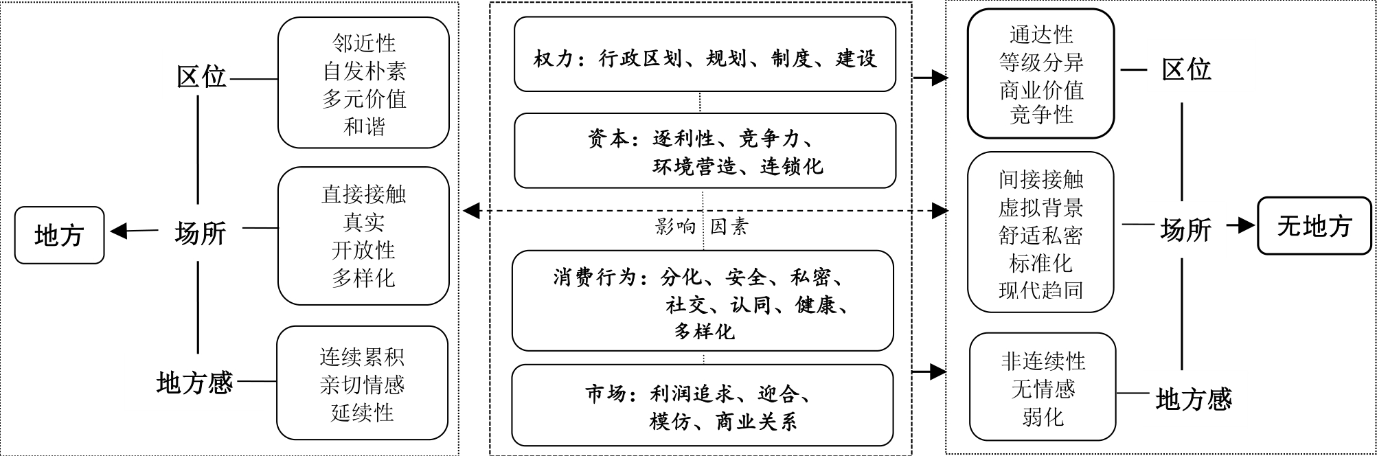
With consumerism prevailing in modern cities, their uniqueness and diversity is gradually disappearing. People no longer pay attention to place significance and traditional values. Therefore, the "place" has become a meaningless activity space, which attracted the attention of several disciplines. However, at present, there are few studies on microgeographic units' delocalization from multiple dimensions, and there is a lack of discussion on the relationships between individual attributes such as emotion, social interaction, and consumption with placelessness. Based on the theoretical framework of placelessness, this study analyzed the process and dynamic mechanism of the evolution of the Heyuan Hakka restaurant into a placeless landscape from a micro perspective. The study showed that: 1) The synergy of power, capital, consumption, and operators contributes to the delocalization of restaurants. The government allocates resources through administrative means, such as administrative division adjustment, planning, and system reform, and begins the reconstruction and commercialization of urban space, which is the external driving force for the evolution of local restaurants. 2) In the course of urban development, local restaurants prefer to operate in new urban commercial centers, and they are gradually moving from older towns to achieve higher commercial efficiency. Therefore, the place significance implicit in the location of a restaurant gradually disappears. 3) To meet the needs of modern food consumption, capital has driven the development of restaurant chains and the integration of food across regions, which has inevitably led to the development of more homogeneous restaurants. 4) Operators believe that higher efficiency leads to higher profitability, so they are increasing their focus on the spatial efficiency of their restaurants. Competition for restaurant locations, environmental construction, and chain expansion reflect space production practices. 5) Local restaurants that gradually gather in the urban business center and surrounding areas alienate their relationship with residents, who find it difficult to engage in daily, frequent, social activities and emotional exchanges in such places. 6) Residents' original intimacy toward local restaurants has disappeared, and it has become difficult to establish a stable emotional connection with the new food consumption space. The main contributions of this study are as follows: First, at the micro level, the study explored how the power of modernity has contributed to the development of placelessness in three dimensions and expanded the study of consumption based on the 'human-object-land' relationship. Therefore, this study responds to the consumption research tendency of the new cultural geography based on the behavior, place, material, and the social-cultural mechanism behind it. Second, a processual analysis of the evolution of place into non-place, revealing the interaction between place and socioeconomic culture in the process of its construction, was completed. Third, this study prompts local restaurant operators to think deeply about their traditions and development processes, guiding operators to re-establish the connections between local restaurants and their communities, which will enhance the social value of local restaurants. Finally, this study enriches place theory, which will promote consumption space development. As a manifestation and consumption space of local culture, local restaurants should allow residents, tourists, and other consumers to experience the unique local culture of their region. This study also has value for the construction of urban consumption space.
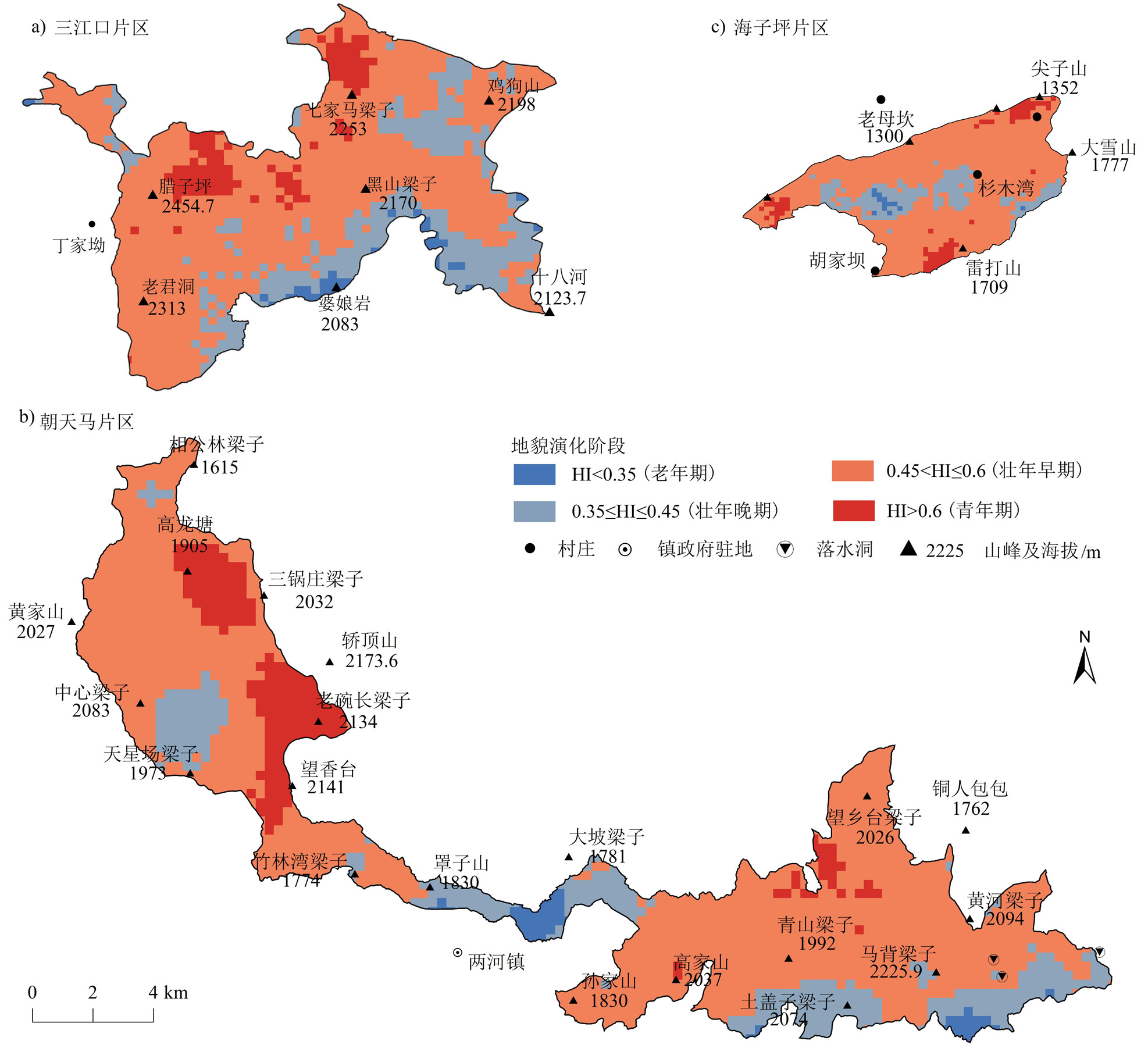
Geomorphic features contribute to variations in regional climate, soil, and other ecological environment factors, which are also an important basis for the biodiversity and evolution of ecosystems. Studying geomorphic features in nature reserves provides a geomorphic basis for resource and environmental management and protecting ecology and biodiversity in these areas. This study revealed the terrain variation, geomorphic patterns, and developmental evolution of the Wumeng Mountain National Nature Reserve by combining quantitative and qualitative methods by investigating geomorphic features and advanced land observing satellite (ALOS) digital elevation model (DEM) terrain analysis. The results indicated that: (1) the reserve elevation was 980~2,454.7 m, with an average of 1,859.9 m, and the undulation was 390~2,104.7 m, with an average of 1,392.1 m. The basic geomorphic types of the reserve were mainly large undulating middle mountains (57.45), large undulating subalpine mountains (30.66%), and medium undulating mesas (11.17%), with an average slope of 21.1°. The gentle slopes (34.83%) had the highest proportion, followed by slopes (31.21%) and gently steep slopes (17.57%). The area of each aspect was the highest on half shady slopes (27.92%) and the least on sunny slopes (21.70%); (2) the reserve was located at the top part of the mountain, with the slope and undulation in the middle of each area being low and the surrounding area being high. From Sanjiangkou to Chaotianma and Haiziping, the average values of geomorphic parameters, such as elevation, undulation, slope, and hypsometric integral, decreased gradually, and there was a trend of progressive reduction in planation surfaces; (3) the terrain profile indicated seven planation surface levels around the reserve. Among them, levels Ⅰ-Ⅲ were the summit surfaces and residual planation surfaces, level Ⅶ was the Jinsha River erosional terrace surface, and levels Ⅳ-VI were the planation surfaces, corresponding to the three tectonic cycles in the area; (4) the hypsometric integral of the reserve ranged from 0.197 to 0.815, with an average of 0.503, and more than 80% of the area was in adulthood of geomorphic evolution, indicating that the surface erosion dynamics of the area was strong, and there was a greater ecological risk with enhanced human activities. Consequently, future conservation planning should consider differences in the surface dynamics of areas with various basic geomorphic types. Geomorphic features form an important part of the natural ecosystems of forest reserves. The unique and rich geomorphic structure enables the conservation and development of biodiversity along with the elements of the ecological environment on which it depends. Geomorphic diversity supports the analysis of the biological formation, evolution, and persistence mechanisms in reserves and provides geomorphic evidence for studying neotectonic activity in the area.
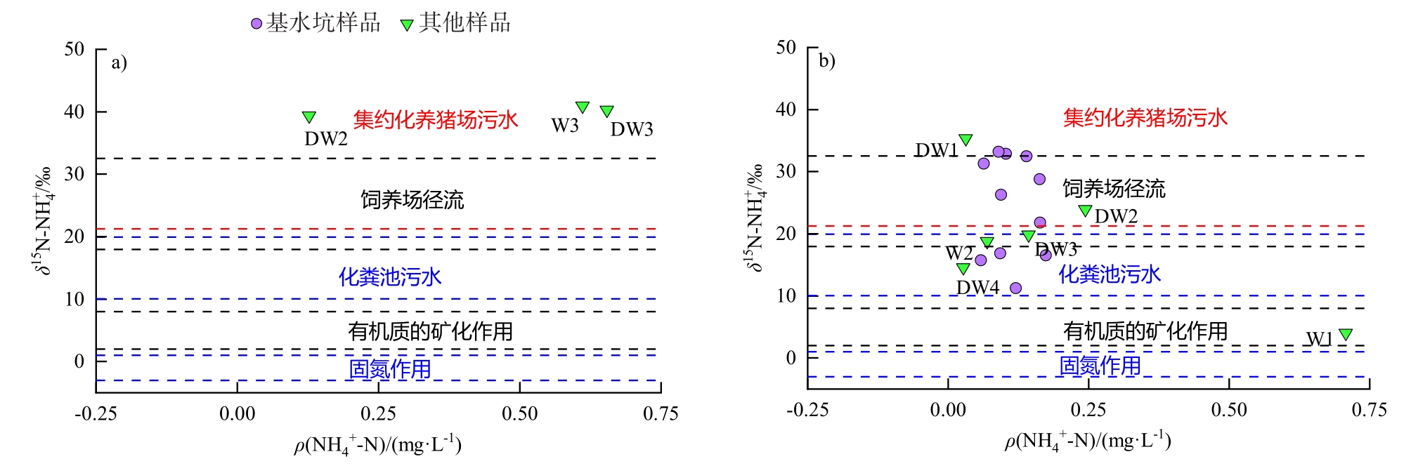
The Maquekengshui basin in Pingshan District of Shenzhen was selected as a case study to reveal the composition characteristics and sources of nitrogen in groundwater, with water samples collected from domestic wells, bore holes with auger, and one foundation ditch in September of the wet season and December of the dry season of 2020. The major sources and transformation mechanisms of nitrogen were identified by combining multiple isotopes in nitrate (15N and 18O), ammonium, and water, and the contribution ratios of different nitrate sources were calculated using the Stable Isotope Analysis in R (SIAR) model. The results are as follows: (1) The main form of nitrogen in groundwater was NO
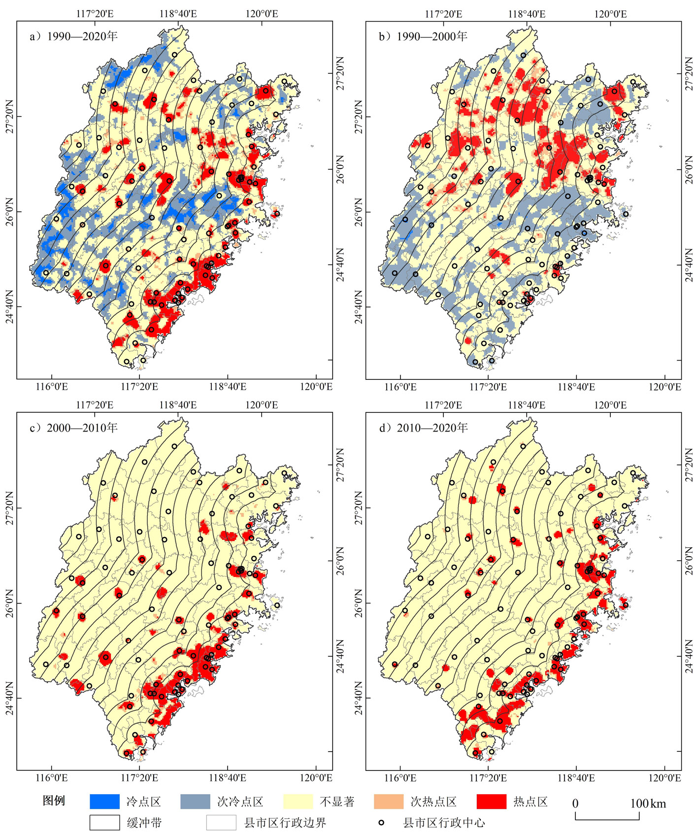
Based on the land use data of Fujian Province in 1990, 2000, 2010, and 2020, we analyzed the spatiotemporal change characteristics of land use types, the spatial differentiation of cold and hot spots under the sea-land gradient using the buffer gradient zone method, and the reasons for spatial differentiation of land use change. The results showed that: 1) the area changes of main land use types had different trends with increased distance from the coastline in the past 30 years. Among them, the change of cultivated land and urban and rural construction land area showed a gradient trend of continuous decrease, and the changes in the area between them within 20 km from the coastline were the largest, which were -1,317.12 and 1,799.8 km2, respectively. The change of forestland and grassland area showed a trend of "decreasing, increasing and decreasing" and concentrated in the 140-240 km gradient zone; 2) from the perspective of conversion types, the proportion of the first 10 land use types changed mainly from cultivated land and grassland to forest and from cultivated, forest, and grassland to urban and rural construction land in the following order: coastal gradient zone (44.23%), transitional gradient zone (37.31%), and inland gradient zone (15.03%). Regarding spatial distribution, the decrease in cultivated land and the increase in urban and rural construction land were mainly distributed in the coastal gradient zone, while the grassland decrease and woodland increase were mainly distributed in the transition and inland gradient zones; 3) from the perspective of the comprehensive dynamic degree, the comprehensive dynamic degree within 20 km from the coastline was the highest (0.75%) in the past 30 years, and the degree of change was the most severe. Concerning a single dynamic degree, the dynamic degree of urban and rural construction land showed a gradient change that first increased and then decreased, and its rate of change was much higher than that of other types; 4) land use change has significant spatial heterogeneity under the land-sea gradient, and taking the year 2000 as the time boundary, the hot spots showed the spatial aggregation characteristics of "transferring from inland areas to coastal areas" and from "more in the north and less in the south" to "more in the south and less in the north". The characteristics of land-sea gradient differentiation of land use change are closely related to regional development strategies and ecological environment construction policies at different stages of Fujian Province from 1990 to 2020.
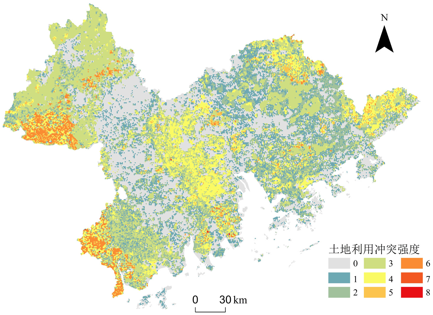
China is currently facing a critical period of economic transformation and social development, with land use being under tremendous pressure, facing multiple challenges. The imbalance in land use structure is becoming increasingly prominent and conflicts over various land uses are becoming more intense, thereby attracting an increasing focus. Land use conflict refers to the inconsistent and disharmonious land use methods and quantities among stakeholders in the process of land resource utilization, as well as the conflicting states between various land use methods and environmental aspects. The study of land use conflicts can provide important references for stabilizing land use structures, alleviating land use conflicts, and optimizing the allocation of national spatial resources. Identifying the spatial range and intensity of land use conflicts is a prerequisite for alleviating regional land use pressure. However, existing research has thus far provided insufficient characterization of the negative ecological and environmental effects of land use. The concept of ecosystem service trade-offs is advantageous regarding expressing the negative effects of land use conflicts and their inherent causes. Therefore, based on the perspective of ecosystem services, this study identifies the intensity and spatial distribution characteristics of land use conflicts in the Guangdong-Hong Kong-Macao Greater Bay Area in different types of space using ecosystem service trade-off analysis. Results show that from 2010 to 2020, land use change in the Guangdong-Hong Kong-Macao Greater Bay Area was relatively drastic, with a decrease of 1,440.90 km2 (8.20%) in arable land area and an increase of 1,649.92 km2 (28.01%) in urban land area. During the study period, carbon fixation, soil retention, and water production services exhibited increasing trends, whereas food supply and habitat quality services exhibited decreasing trends. High-gain areas of food supply and carbon fixation, as well as high-loss areas of water production and soil retention, were mainly distributed in the southwest and northwest of the study area. The land use conflict index of the study area was 1.05, indicative of strong land use conflict. This was mainly because the study area had a large number of service types to balance, with the balance relationships being strong. Among them, the balance relationships between water production and food supply, habitat quality, and carbon fixation were the dominant factors in land use conflicts in the study area. The intensity of land use conflicts in each subregion ranged from strong to weak in the following order: natural or semi-natural area (1.10) > semi-natural semi-artificial area (0.97) > artificial area (0.77) > semi-natural area (0.45). Natural or semi-natural area was the main area of land use conflicts, mainly because this area had many service types to balance, with the balance relationships being strong. In terms of spatial distribution characteristics, the spatial distribution range of land use conflicts in the study area was mainly characterized by weak and moderate conflict areas; however, land use conflicts were more severe in some local areas. The spatial distribution structure of land use conflicts in the study area showed a medium-weak-medium pattern from the periphery to the central part. Strong and extremely strong conflict areas were concentrated in natural or semi-natural areas.
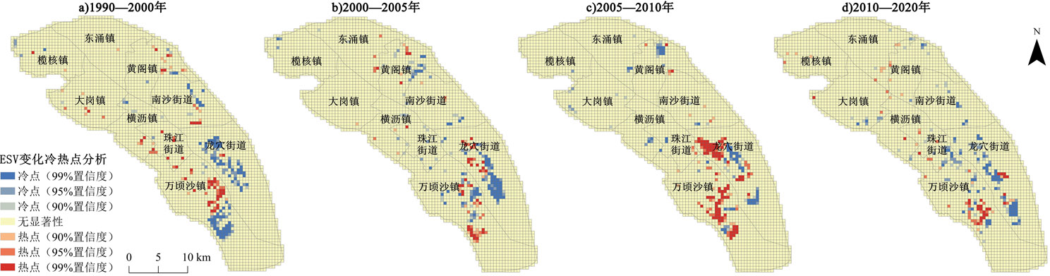
Administrative division adjustments (ADAs) have been key in optimizing regional resource allocation and spatial governance. The impacts of ADAs on regional ecosystems remain unclear in the "green turn" process of China's urbanization. This research chose Nansha District, Guangzhou, as a study area due to its frequent ADAs and its changing location in the Guangdong-Hong Kong-Macao Greater Bay Area in the past 30 years and investigated the relationship between Nansha's ADAs and the changing Ecosystem Service Values (ESVs) from 1990 to 2020 through applying the equivalent factors, hotspot analysis, and gravity analyses. The study reveals that in the rapid urbanization process, frequent ADAs have affected regional ecosystems and ESV changes, with pros and cons. First, there were strong relations between the ADAs and regional ESVs during 1990-2020. The total ESV of Nansha decreased first but increased later, then again decreased according to the ADAs that happened in 1990-2000, 2000-2010, and 2010-2020. Second, land uses in Nansha District have varied because of urban sprawl since the ADAs. Ecosystems were degrading as a result of the increase of construction land and the depletion of farmland and woodland areas. . Third, at the same time, gaining higher administrative privilege had facilitated local governments to promote the restoration of the ecosystem, particularly the enhancement of wetlands, which led to a growth in regional total ESVs in Nansha. It reveals that regional ecosystem services will undergo a phased, multi-level, and multi-faceted change because of the changes in local governance, the diversification of land uses, and the various land development models. This study fills the gap in studying relationships between changes in ecological system services and ADAs at the district (or county) level. The regional ecosystem services of Nansha are sustainable, as more than 40 percent of the total land is ecological. Therefore, it suggests Nansha District Government should take the chance of ADAs to enhance its privilege in regional spatial governance by cooperating with other local governments in the Greater Bay Area through constructing, governing, and sharing a high-quality ecological conservation and restoration landmark of the rivers and shorelines. It also calls for more attention to the impacts in different phases with multiple levels and dimensions caused by the roles of governments and the land development models rather than merely assessing the changing land use structures and the overall ESV.