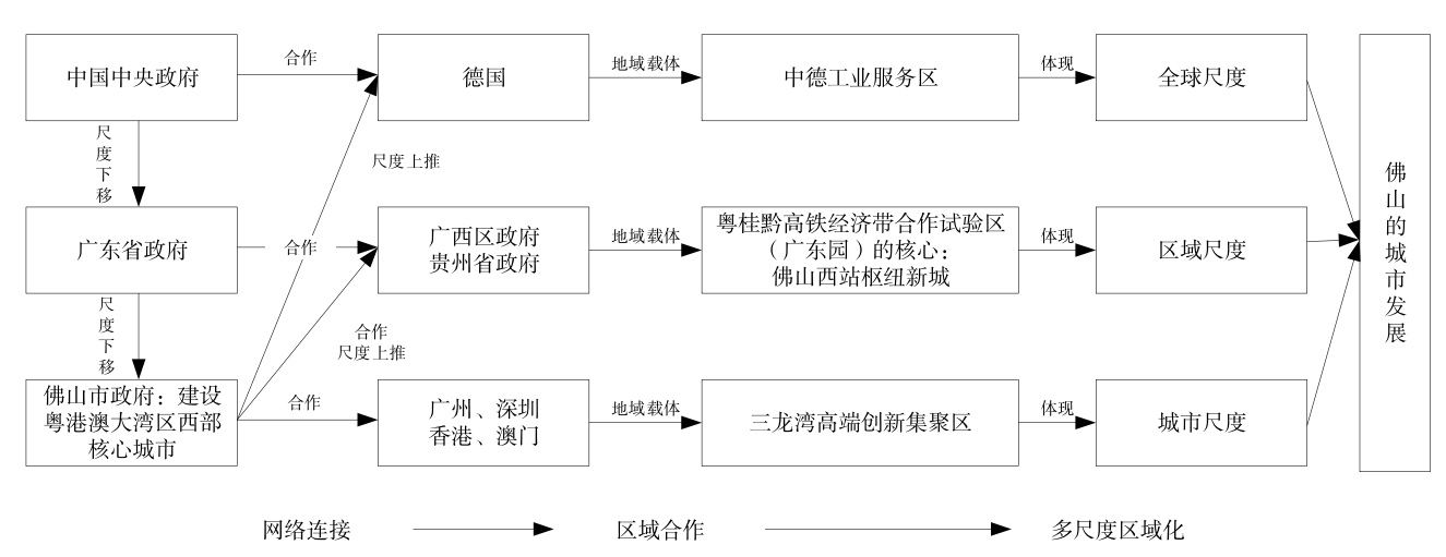
The social construction of region has received little attention from Chinese scholars; there are few studies regarding the Guangdong-Hong Kong-Macau Greater Bay Area from the perspective of city government’s actions and strategies. Instead, most of the literature focuses on its political impacts, economic patterns, and urban spatial structures. This paper adopts the discourse analysis method to explore the policy and response strategy of Foshan integrating into the construction of the Guangdong-Hong Kong-Macau Greater Bay Area, with the intention to fill in the gap mentioned above. This approach allows for an analysis of how local governments are embedded into the larger network during the process of regional construction to expand urban development space and achieve more economic development. Additionally, it will enrich the literature with information about the construction of the Guangdong-Hong Kong-Macao Greater Bay Area from the perspective of urban government. This study found that Foshan has constructed its regional identity as the core city of the western part of the Guangdong-Hong Kong-Macau Greater Bay Area, and this helps determine the strategy and direction for how Foshan might integrate into the Guangdong-Hong Kong-Macau Greater Bay Area through strategic unification. In particular, Foshan is neither a provincial capital city nor a Special Economic Zone, making it difficult for Foshan to have the same political status and administrative power as Guangzhou, Shenzhen, Hong Kong, and Macao. There is also a certain disparity in the allocation of resources. In this context, Foshan has established a network of relations with different cities and regions, forming different regionalization at different scales, including the urban, regional, and global scales. These strategies are reflected in three aspects. At the urban scale, Foshan connects to cities, including Guangzhou, Shenzhen, Hong Kong, and Macao, and it has built the Sanlong Bay high-end innovation cluster (Sanlongwan) as a regional platform, which aims to reconsolidate resources. This improves Foshan’s ability to coordinate regional development and fosters new local growth poles to maintain a competitive advantage. At the regional scale, Foshan aims to connect to the Guangxi and Guizhou provinces, building the Foshan West Railway Station Hub at New Town (Foshan Xizhan Shuniu Xincheng) as a regional platform, making the Guangdong-Guangxi-Guizhou High-speed Railway Economic Cooperation Zone(Yue-Gui-Qian Gaotie Jingji Hezuoqu) and even the Southwest China as its economic hinterland. At the global scale, Foshan is connected to Germany, building the Sino-German industrial service area (Zhongde Gongye Fuwuqu) as a regional platform, which has created local-global connectivity channels, embedding itself into the global market economy. The Foshan case demonstrates how the region, as a confluence of multiple factors at different scales, generates important insights into how new state spaces of development are produced and reproduced to dovetail regional assets with national and transnational economic ties. This study responds to the New Regional Geography from the perspective of social constructivism to examine regional development issues. Additionally, it responds to the latest appeals for China’s urban network research, and in practice, it clarifies how other cities can more easily integrate into the construction of the Guangdong-Hong Kong-Macau Greater Bay Area, and these results may even be useful for regional development.
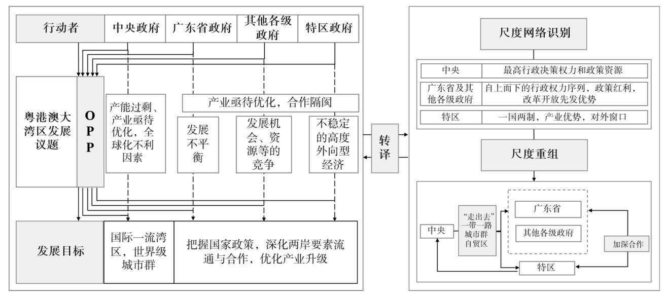
Rescaling is a tool to explain the participation of territorial organizations, such as nation-states and cities, in global competition. Considering the cross-border cooperation between Guangdong, Hong Kong, and Macao since the reform and opening up in South China as an example, this study draws on the research methods of the Actor-Network Theory to analyze the rescaling process of the three “new state spaces,” including the Pearl River Delta, the Greater Pearl River Delta, and the Guangdong-Hong Kong-Macao Greater Bay Area and reveals the political and economic logic of the state rescaling of China. It was found that the power and resources of the actor determine its position in the scale network and that the formation of China’s “New State Space” is primarily driven by the central government, with decisive importance being the development goal. Other actors, such as the Hong Kong and Macao SAR governments, the local governments of the Guangdong Province, township enterprises, and multinational corporations, have combined their development goals with that of the central government to form an “Obligatory Passage Point”. Throughout the three-stage evolution process, the importance of institutional factors has become increasingly prominent.
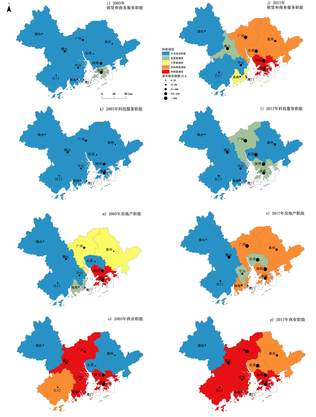
The Guangdong-Hong Kong-Macao Greater Bay Area has become the most important national strategic zone in China because of its key engine-like role for economic growth as well as being the most advanced global mega-city region in China. The mega-city region development is based on reasonable labor division and cooperation between cities. Cities should focus on their strengths and boost regular competition to promote the coordinated development of the entire region. This study examines the Guangdong-Hong Kong-Macao Greater Bay Area, which includes 19 national economic industries that are divided into 11 city functional types. Based on the data concerning the industry practitioners in each city in 2003 and 2017, this study uses the location quotient index, urban basic service scale measurement method, and Nelson urban functional intensity index to analyze the dynamic evolution of city functions in 2003 and 2017 from the perspective of three elements of urban functions. Further, the influence factors of evolution are analyzed according to the economic, political, and social aspects. First, the urban agglomeration of the Guangdong-Hong Kong-Macao Greater Bay Area is dominated by the manufacturing and production services, with a high specialization level being observed for the manufacturing and service functions, and the evolution of these functions exhibits obvious spatial heterogeneity and industry differences. Second, at the regional level, the basic functions of the Guangdong-Hong Kong-Macao Greater Bay Area include the manufacturing industry, commerce, real estate industry, leasing business services, and software information services, whereas the non-basic functions include transportation, finance, scientific research and technology, education, culture and health, and other services and industrial functions. The functions of the service industry are observed to be significantly enhanced from 2003 to 2017. Third, at the city-scale level, the urban functions of the Greater Bay Area are primarily undertaken by the four major central cities of Hong Kong, Macao, Guangzhou, and Shenzhen, with uneven development being observed between the central and peripheral cities. However, the status of the manufacturing function in central cities declined with the rapid growth of the producer service functions and high specialization levels. In particular, Guangzhou and Shenzhen, which are two core cities in the Pearl River delta, have rapidly improved their functional status and exhibit comparatively increasing advantages with respect to transportation, software information, leasing businesses, and scientific research and technology, challenging the functional status of Hong Kong and Macao. However, the remaining node cities are dominated by the manufacturing functions, and their service functions exhibit a relatively low level of specialization. Foshan, Dongguan, Zhongshan, and Huizhou are cities that dominate with respect to the manufacturing industries, whereas Zhuhai exhibits a relatively good service function development and can build a sub-center of services in the bay area. Jiangmen and Zhaoqing have improved their functions; however, their urban influences and strengths are weak. Fourth, the evolution of urban functions in the Guangdong-Hong Kong-Macao Greater Bay Area is primarily influenced by the urban location conditions, the economic development level, the regional development policies and strategies, the economic globalization, and the most recent round of technological revolutions. In the future, policymakers and planners should focus on achieving a reasonable division of the urban landscape by relying on information technology to promote the development of the integration of manufacturing and services, promoting the transformation and upgradation of industries, and accelerating the regional system innovation and cooperation to achieve high-quality integrated development in the Guangdong-Hong Kong-Macao Greater Bay Area.
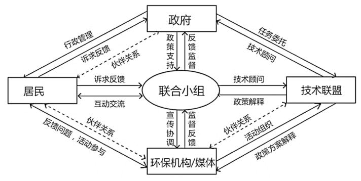
Over the past decade, concerns regarding cross-regional environmental management in the Guangdong-Hong Kong-Macao Greater Bay Area have been increasing. However, problems still persist regarding the development of cross-border environmental governance and the lack of sustainable cooperation mechanisms. Pursuing a transition toward a more sustainable environmental management system has become imperative for solving cross-regional environmental problems encouraging multiple stakeholders’ participation. Collaborative environment management is of considerable significance for promoting cross-regional coordination of sustainable development. Scholars in China have paid particular attention to introduce collaborative environmental management approaches, but in practice, research is particularly oriented by problems, and such approaches lack a sustainable regional environmental management coordination mechanism. This paper examines the mechanism of the watershed collaborative planning at the cross-border rivers located in the Guangdong-Hong Kong-Macao Greater Bay Area. The Danshui River, Shenzhen River, and Yayong Canal were chosen as cases for comparative analysis with the cross-border rivers, and the similarities and differences of these were studied. The results and conclusions are as follows. First, the management of the Danshui River is dominated by multi-level government departments, and the partnership process is gradational. The governance of the Shenzhen River is a collaborative process of policy and market coordination involving multiple stakeholders, and the partnership process is cyclic and alternating. Moreover, the governance of the Yayong Canal is a collaborative process dominated by government-based policies, and there is an asymmetric partnership. Second, the administrative system is the surface factor that affects the governance of cross-border rivers, and internal factors contribute to the differences in achieving partnerships between the stakeholders. Thus, the governance results are influenced by differences in collaboration models, planning information, and mechanism design. Third, to some degree, the cooperation mechanisms of Guangdong,Hong Kong and Macao could promote cross-border river management. In particular, the Shenzhen River mixed-management mode involving multiple stakeholders represents a progressive expression of cross-border river management. Furthermore, the cases mentioned above have common problems, such as lacking consistent planning objectives, multilateral cooperation, public collaboration, awareness, and a sustainable collaboration mechanism. In this context, establishing a sustainable, regional environmental management goal, innovating the regional environmental management coordination system, and improving public participation could be instrumental in the process of developing an environmental management coordination framework in the Guangdong-Hong Kong-Macao Greater Bay Area.
The transformation from the urban agglomeration of the Greater Pearl River Delta to the Guangdong-Hong Kong-Macao Greater Bay Area has essentially been a transformation from economic development-oriented growth supremacism to life quality-oriented post-growth supremacism. In the post-growth supremacism period, public construction has become an important topic. First, this study briefly reviews the basic connotations and meanings of publicity. Second, primarily based on the requirements of post-growth supremacism, self-examinations of the regional culture, the reversed transmission of public opinion, and the necessity and possibility of the construction of publicity in the Guangdong-Hong Kong-Macao Greater Bay Area are analyzed. Third, we focus on how Hong Kong and Shanghai promoted the construction of publicity. The experience of Hong Kong included the relatively strong independence and autonomy of its social organizations, and community construction in Hong Kong had basic characteristics of diversified participation and professional guidance. The experience of Shanghai included two aspects in terms of the physical public space: it emphasized government-led and multi-party participation in terms of the virtual public space and attached great importance to build a public opinion platform environment with broad, controversial and inclusive topics. Finally, two suggestions are presented: 1) to study the construction of publicity in Hong Kong, which was characterized by a society-led model and 2) to learn from Shanghai to build a government-dominated public space building mechanism, together with a more open and looser public platform and public opinion environment.
Increasing globalization and informatization has enhanced the intercity exchange of information, materials, and energy. Cities no longer represent isolated systems. Instead, they are closely linked to each other, forming regional or global city network systems. Therefore, the study of urban networks has attracted massive attention in human geography and urban planning. In particular, the emergence of the concept of “space of flow” provides a new perspective and paradigm for the interpretation of regional spatial structure. Based on the data collected from domestic and foreign journal database published from 2000 to 2018, this paper uses social network analysis method and spatial structure index method to explore the evolution process of the overall characteristics, organizational structure, and the spatial pattern of the knowledge network in Guangdong-Hong Kong-Macao Greater Bay Area. Furthermore, it identified the evolution trend of factors influencing the knowledge network in the Bay Area. The results also revealed the following: 1) Over the duration of the research, publications in the Greater Bay Area significantly increased. The pattern of the knowledge network gradually evolved from the “single power” represented by Guangzhou to “simultaneous development” that included Guangzhou, Shenzhen, and Hong Kong. Although Hong Kong is at the core of the knowledge network, it establishes close knowledge cooperation primarily with Guangzhou and Shenzhen due to administrative barriers. 2) The knowledge network of the Guangdong-Hong Kong-Macao Greater Bay Area represents a “core-edge” structure with the knowledge connection in the western region significantly lower than that in the eastern region. The knowledge network densities and spatial structure indices of the Guangdong-Hong Kong-Macao Greater Bay Area suggest an increasing volatility. In 2016, the knowledge network density of the Bay Area attained the maximum value, indicating the development and maturity of the overall knowledge connection of the Guangdong-Hong Kong-Macao Greater Bay Area. In addition, the spatial structure indices demonstrate an alleviation of polarization characteristics of knowledge networks in the Bay Area, despite persistent significant imbalance. 3) The demand of the knowledge activity actors such as universities and scientific research institutions in the Bay Area is the internal driving force promoting knowledge cooperation among cities. The knowledge environment and the knowledge connection channels are the external driving forces of the regional knowledge cooperation network. The influence of endogenous and exogenous factors is responsible for the output of knowledge cooperation, resulting in the development of the knowledge network in the Guangdong-Hong Kong-Macao Greater Bay Area. This study provides a reference for the development of innovative collaborative paths in the Guangdong-Hong Kong-Macao Greater Bay Area by refining the characteristics of Bay Area’s knowledge network.
Consider the Guangdong-Hong Kong-Macao Greater Bay Area as an example, this paper proposes a Multi-source Image Fusion Stitching Model (MI-FSM) for multi-source Land Surface Temperature (LST) images on a large-area study area; this model is based on the existing Spatio-Temporal Image Fusion Model (STI-FM). MI-FSM can eliminate the influences of different time and weather differences in the Landsat 8 data, realize seamless splicing between images, and generate medium- and high-resolution surface temperature data covering the Greater Bay Area. The data sources selected in the study were the Landsat 8 LST obtained from original Landsat 8 images via a surface temperature inversion algorithm and the MODIS LST 5d synthetic product. First, using the STI-FM fusion MODIS LST and Landsat LST, multiple Landsat LSTs of different phases were synthesized into LST images with uniform specific phases. Then, the synthesized LST images were mosaic-processed to splice multiple Landsat 8 LST images in the Guangdong-Hong Kong-Macao Greater Bay Area. To verify the applicability of STI-FM in the study area, this paper selected two groups of Landsat 8 LST images, “summer-summer” and “winter-summer,” in the center of the study area and compared and evaluated the synthesized Landsat LST concerning the verification data. In the “summer-summer” verification group, the minimum, maximum, mean, and standard deviation between the synthesized LST product and the actual LST were 0.01, 1.02, 0.10, and 0.03, respectively, and the coefficient of determination (R 2), Root Mean Square Error (RMSE), and Absolute Average Difference (AAD) were 0.849 5, 0.655 9, and 0.690 6, respectively. In the “winter-summer” verification group, the minimum, maximum, mean, and standard deviation between the synthesized LST product and the actual LST were 0.07, 0.08, 0.42, and 0.99, respectively, and R 2, RMSE, and AAD were 0.681 7, 1.375 3, and 1.012 9, respectively. The results show that STI-FM has a strong applicability in the study area. Finally, the accuracy of the model was further verified via an accuracy evaluation: the degree of fitting between different time-phase MODIS LST images was high, the R 2 value was between 0.6 and 0.9, and the RMSE was <1.5. Additionally, we selected three typical land cover types, cities, woodlands, and paddy fields and discussed the spatial distributions of their errors. The analysis results show that a linear relation is the most significant in cities, followed by paddy fields, and that the paddy fields are sensitive to seasonal differences. Woodlands have the poorest adaptability to the model, and there is no obvious relation with the errors for the woodlands. An evaluation was performed to prove that the results were reasonable: a visual analysis of the overall and local details indicated that the results of the fusion stitching were ideal.
A survey of the typical regional development models in the Guangdong-Hong Kong-Macao Greater Bay Area used to adapt to the flood environment between the 17th century and 1950s indicates that three main models are formed in this area in accordance with the different characteristics of floods and tides. 1) The low-water areas of Zhaoqing, Gaoyao, Qingyuan, and Sanshui in the north are primarily affected by floods, and the fish fry resources during the Xijiang flood periods are used for vortex pond cultures to develop the cultivation of waterlog-tolerant deep rice and economically valuable aquatic plants. 2) The central South China Sea, Shunde, and Gaoming flood tide superposition areas have been generally developed into continuous mulberry fish ponds to develop a set of technical systems for flood control and flood resistance as well as to utilize tidal drainage and irrigation during the flood periods. 3) The coastal entrance areas of the Zhongshan, Panyu, Dongguan, and Xinhui areas are dominated by tides, and the local technical measures, such as the addition of rocks to build small spur dikes and planting grasses, can accelerate sediment deposition as well as the enclosing, reclaiming, and developing of the tidal flat. During the tidal flat development process, the flood tides can be creatively used to accelerate the succession of the tidal flat plant community as well as to aid in drainage and irrigation, the improvement of paddy soil, and the selection of suitable crops. The three aforementioned development models illustrate the concrete practices in the Guangdong-Hong Kong-Macao Greater Bay Area that transform potential harm into a methodology to benefit regional development. Furthermore, the harmony between humans and water in this region directly promotes the construction of an ecological civilization in the Guangdong-Hong Kong-Macao Greater Bay Area.
Currently, significant institutional differences and uneven development exist in regions in China. Thus, integrating economic geography and institutional research is necessary. Previously, economic geographers paid considerable attention to the evolution and current characteristics of economic geography or the methods and concepts of institutions regarding economic geography. There have been few discussions on the relation between economic geography and institutional studies in history. Thus, in this paper, first, we briefly reviewed the historical relation between economic geography and institutional research, and we determined that economic geography and institutional research were separated but then integrated. However, the situation of integration of the economic geography and institutional research is still unclear. Second, we analyzed the current development status and deficiencies of institutional research of economic geography based on three aspects: institutional economic geography, geographic economics, and evolutionary economic geography. Third, we describe the orientation of the construction of institutional theory for economic geography. The construction of institutional theory should be based on evolutionary economic geography, existing research of economic geography, and other disciplines. Finally, to construct institutional theory, the following measures should be adopted: 1) pay considerable attention to building the hierarchical structure of the institution under the guidance of system theory and the hierarchy view, 2) seek methodological breakthroughs on the basis of anti-reductionism, 3) emphasize the role of time in the institutional system via evolutionary thinking and path dependence theory, 4) strengthen institutional research on various spatial scales, and 5) pay attention to the reference and innovation of tools and methods.
Boosted by industrialization and urbanization, China’s economy has become more oriented to growth. Along with this trend, the “urban era” is emerging, and the gap between rich and poor is increasing sharply within China’s cities. Available living space is therefore being rapidly reconstructed, and social space continuously differentiated. On the basis of data from the Sixth National Census, this paper explores the socio-spatial differentiation of the new migrants in Shenzhen, a typical migrants’ city in China, through calculations of the dissimilarity index, the isolation index and the Location Quotient. In addition to applying a linear regression model, this paper also analyzes the factors influencing spatial differentiation of new migrants in Shenzhen and compares these with Guangzhou to explore the similarities and differences of socio-spatial differentiation and its influencing mechanism in different cities. The empirical analysis shows that, first, there are five types of social spaces in Shenzhen, including elite-stratum neighborhoods, working-class ghettos, retired-population neighborhoods, urban villages, and new-migrant neighborhoods. Second, the spatial distribution of new migrants is uneven at the city level: the intra-province migrants are more concentrated inside the special economic zone (SEZ) of Shenzhen (where Futian District, Luohu District, Nanshan District and Yantian District locate), while inter-province migrants concentrate outside the SEZ (where Baoan District, Longgang District, Guangming New District, Longhua New District, Pingshan New District and Dapeng New District locate). Third, the dissimilarity index between the new migrants and the local residents is 0.47 and the isolation index is 0.64 in Shenzhen, higher than the same indices in Guangzhou, which indicates a higher degree of isolation among new migrants in Shenzhen. Moreover, there are significant differences on the degree of isolation between the districts of the SEZ and those outside the SEZ. This situation mainly stems from the differences in the level of economic development and the industrial structure, which is different from the suburbanization of migrants dominated by market factors in other Chinese cities like Guangzhou. Fourth, the results of the linear regression model show that the effects of institutional factors (Hukou-account attributes) on the spatial pattern of new migrants have decreased, while the role of market factors is increasing in this regard, in line with the assumption of “transition to a market-oriented economy”. Besides, demographic characteristics have significant influence on the spatial pattern of new migrants, especially with regard to the effects of age and educational level. Fifth, by contrast, the spatial pattern of new migrants in Guangzhou is impacted not only by the dual influences of institutional and market factors but also by the age structure and marital status. The household registration system continues to exert influence on spatial patterns in Guangzhou. It can be seen that the socio-spatial differentiation of new migrants and its mechanism show a pattern of heterogeneity in different cities. At the leading edge of the reform and opening-up policy, Shenzhen reflects the characteristics of social space under the influence of China’s transformation of socialist market. After the reform and opening-up policy more than 30 years ago, the shifting influences of “system-market” factors and the effect of the transition are particularly evident in Shenzhen. Against the historical background of the government and the market’s influence, the socio-spatial pattern in urban China is gradually developing into a “market-oriented” model.
Under China’s national transit priority development strategy, generally, local governments have a high level of incentives for developing urban rail transit systems to meet transport demands in high-population density areas. Usually, rail transit systems bring significant positive external benefits; adopting Land Value Capture (LVC) can significantly relieve financial burdens on local governments and promote the implementation of transit metropolis strategy. Developed regions such as Europe and America have actively implemented diversified land tax-oriented LVC programs to finance rail transit systems. Chinese cities mainly focus on land development-oriented LVC programs as a financing tool; however, this financing model’s implementation mechanism and effectiveness on rail transit development face a lack of systematic research. Since 2011, Dongguan, a city in China’s Pearl River Delta, has issued a series of active policies promoting land development around rail transit sites and feeding rail transit financing with land added values. However, implementation methods of the development based LVC in Dongguan and how to legitimately evaluate policy frameworks and implementation processes to reach LVC policy goals remains unclear. These issues are crucial for local governments in China to promote LVC’s potential to finance rail transit. This article attempts to explore these issues and reveal LVC policy framework and effectiveness at financing urban rail transit systems. A case study of the LVC financing tool in Dongguan, China, was conducted using policy analysis methods. This study concludes that 1) the concept of LVC internalizes positive externalities in a specific way. Compared to land-tax-based LVC programs in the United States, LVC practices in China largely follow a rail and property joint development concept. 2) LVC in Dongguan involves a series of relevant institutional arrangements, including transit-oriented development planning, land controls and reserves around transit-served areas, transfer of land development rights, and distribution of land development benefits induced by rail transit investment. 3) Land development around rail stations can generate financial gains, potentially accounting for more than 20% of the rail transit system’s funding demand in Dongguan. LVC policy and implementations still require certain policy innovations to improve economic efficiency and the fair distribution of added land values. This study can provide policy implications for other local governments planning to use LVC as an additional financial source for rail transit investment needs. A better LVC implementation not only relies on coordination between transportation and land-use planning, but also a high-level connection between spatial planning and the urban fiscal system. Establishing a new spatial planning system in China would provide a new opportunity for LVC to fund rail transit systems. In the future, LVC could also be applied to other urban and regional development fields relevant to financing issues.
This study analyzes the present technologies related to environment sensing and intelligent crisis response, and integrates Virtual Reality (VR) and Internet of Things (IoT) technologies to implement a real-time geographical environment monitoring system aimed at solving the real-time monitoring and intelligent reaction needs of the ecological monitoring and protection of a remote island. The system adopts Browser/Server (B/S) architecture that contains four layers, a sensor layer, network layer, service layer, and application layer, forming complete technical processes beginning with data perception, data transmission, and data computation and finalizing in data application. Tables are designed according to environmental monitoring sensors that are mainly utilized in the water, soil, meteorology, and vegetation monitoring, thus achieving a unified storage and management system of multi-source heterogeneous sensor data. IoT technology is adopted to connect the sensors, servers, and computers into a unified network that achieves wireless transmission and both the access and remote storage of geographical environment data (e.g. water, soil, air and biology) from which the dynamic changes of water quality in the harbor, soil drought in the thicket, and meteorology in the island area can be displayed and evaluated; in this manner an early warning for abnormal changes in the environment can be obtained. VR technology is used to navigate and perform operations in both the indoor and outdoor modeled and integrated island scenery. Moreover, by integrating VR and IoT technologies, remote control of the intelligent sensing device is achieved; for example, this control is applicable for vegetation watering valves and lights. Using this system, a manager can not only obtain real-time geographical environment data and identify any abnormal changes of environmental features, but also remotely control intelligent sensing devices. Consequently, manual management of the island is no longer needed, and working efficiency is improved.
To analyze the differences between groups and grasp the transformation characteristics of group identity, an operational definition of heritage identity from the perspective of subjectivity and objectivity, and the theoretical framework of formation path of heritage identity is constructed in this study. Thereafter taking Laoshicheng, Yongshun, a world cultural heritage, as a case study, the paper conducts theoretical deduction research under this framework. Data are collected by literature review and semi-structured interviews, and cleans data by using discourse analysis. The findings of the study are as follows: 1) The objective heritage identity of Laosicheng is the production of a heritage that has been produced, defined, reused, and destroyed during process of inheritance. In other words, Laosicheng represent a political place where the central government governed minority areas. It is a heritage site which is recognized at all levels (local, provincial, national and worldwide) and important cultural tourism resource and a tool for residents’ livehood and well-being. 2) The subjective heritage identity of Laosicheng invloves the recognition, emotion, evaluation and behavior of attachment groups in the process of inheritance. The heritage identity of different groups shows heterogeneity: staff of government and management agency regard Laosicheng as a cultural heritage with unique value and tourism resource that can drive local development; experts and scholars view Laosicheng as an important archaeological site to study the Tusi culture; in the eyes of residents Laosicheng is the historical legacy for enhancing ethnic cohesion and improving life; and tourists seek new knowledge and feelings of nationalist sentiment through visiting this heritage site. 3) The objectivity and subjectivity of Laosicheng’s heritage identity are transformative, which are determined by the function of the heritage itself and the different utilization of attached groups in the process of heritagization. Therefore, it is of great significance for heritage protection, utilization and management to formulate appropriate heritage development strategies, guide different groups to form positive identity and exhibit the value of heritage correctly.
Drawing on the concept of enterprise growth in economics and management, taking Hongcun as a case study, the study used qualitative research methods such as in-depth interviews and non-participation observation to analyze the quantitative and qualitative characteristics of the growth of small tourism enterprises and its influencing factors. The findings of the study are as follows: 1) After nearly 40 years of development, Hongcun small tourism enterprises have witnessed a sharp increase in the number of enterprises and employees, a gradual enrichment of enterprise types and products, an expansion of the overall business scale and business space, and a decline in the growth rate of business profits. At the same time, the management experience and innovative development ability of small tourism entrepreneurs have continuously improved, the hardware and software services of enterprises have become more standardized and humanized, the old brand of enterprises has continued, new brands have been produced, and the characteristics of enterprise agglomeration have been remarkable, all of which has produced a greater agglomeration economic effect. On the whole, Hongcun small tourism enterprises are in the process of continuous optimization of quantity growth and quality improvement, and are realizing their sustainable growth in tourism destinations. 2) Tourism market environment, scenic area management systems, entrepreneurship, local traditional culture, enterprise growth strategy, and enterprise competition and cooperation interaction have jointly promoted the establishment and growth of Hongcun small tourism enterprises. The rapid growth in the number of tourists and tourism demand in Hongcun, the management and construction of scenic spots by tourism companies and local governments, the initiation and imitation of innovative spirit by local entrepreneurs, the individual characteristics of endemic entrepreneurs, and the spirit of reform and innovation all directly or indirectly promote the growth of small tourism enterprises. Traditional Huizhou merchant culture, clan culture, and neighborhood culture are the social and cultural support for the growth of small tourism enterprises and they strengthen the stability of small tourism enterprises in the growth process as well as their ability to resist external risks. The growth strategies of enterprises, such as imitating innovation, chain expansion, and group development, have promoted the integration, diversification, and joint growth of small tourism enterprises. At the same time, the homogeneous competition of low-level products promotes the higher-level qualitative growth of small tourism enterprises. The cooperation and exchange among multi-group small tourism entrepreneurs strengthens information exchange and resource sharing among enterprises, and greatly promotes the growth of small tourism enterprises. Finally, further research directions are pointed out: A case study on the agglomeration of small tourism enterprises with different regional cultural traditions and different business entities could be conducted. This study probes into the characteristics and influencing factors of small tourism enterprises in different growth stages and encourages continuous follow-up study focusing on the growth quality, policy environment, and enterprise cooperation of small tourism enterprises.
Most precipitation seeps underground and is difficult to capture because of the poor water-holding capacity of soils in karst areas and dual aspects of the hydrogeological structure formed by karstification. Therefore, soil-moisture estimation is critical for karst ecological restoration in karst area and for agricultural development. Using the Yangmei River basin as the research area, environmental factors, such as Normalized Differential Vegetation Index, Wetness Index (WI), altitude, slope, and relative height, were extracted from remote-sensing imagery and Digital-Elevation-Model data. On the basis of correlation analysis, WI was chosen as an auxiliary variable. Spatial soil-moisture interpolation by four methods, namely ordinary kriging, cokriging with WI vector point as auxiliary, cokriging with WI raster, and kriging combined with regression, were applied to soil-moisture sampling and WI raster data. Root Mean Square Error of predicted and measured values and unary linear regression between predicted and measured values were used to estimate the accuracy of different interpolation methods. Results showed the following: 1) From correlation analysis between soil moisture and other environmental factors, we found a significant negative correlation between WI, which is associated with near surface humidity condition, and soil moisture (P=0.01) but no significant correlation between other environmental factors and soil moisture was found. According to the outcome of stepwise regression, WI was chosen and other environmental factors were removed. 2) Kriging combined with regression had the smallest error of estimation in soil moisture in the study area; cokriging had a larger error, and common kriging had the largest error. When interpolating soil-moisture samples by cokriging, using WI vector-point data was more efficient than WI raster data as the auxiliary variable. 3) The soil-moisture surface generated by ordinary kriging was the smoothest, but kriging combined with regression reflected the soil-moisture spatial pattern for the study area to the greatest extent. However, in general, the spatial variation of soil-moisture interpolation results generated by the four methods was all lower than the actual condition as observed. 4) When fewer soil-moisture sample points were used for interpolation, errors of average value and spatial variation results of the four interpolation methods were larger. However, no matter what number of soil-moisture sample points were used, average values of soil-moisture interpolation results from kriging combined with regression were lower than those of ordinary kriging and cokriging, and spatial variations of soil-moisture interpolation results were higher than those of ordinary kriging and cokriging. In conclusion, the accuracy of kriging combined with regression is better than ordinary kriging and cokriging applied in soil-moisture interpolation in karst areas, which were consistent with the result of other research comparing the accuracy of different interpolation methods. To improve the accuracy of the soil-moisture interpolation results, we would need more soil-moisture sample points and higher resolution remote-sensing imagery to extract more-detailed information on environmental factors, particularly those more significantly correlated with soil moisture.
Information and communication technology reshapes resident behavior and urban spaces. Emerging online shopping has changed residents’ shopping preferences and processes, which inevitably affects the physical business space. However, there are some differences in shopping behaviors of different types of goods. Current research focuses on online shopping behavior for books, clothes, and other commodities, but seldom explores online food shopping behavior from the spatial perspective. Based on 1406 questionnaires on the food shopping behavior of residents in Guangzhou, we compared the behaviors of food purchasers whether to buy online, who buy food online in different locations and with different frequencies. General and spatial characteristics of food shopping behaviors of Guangzhou residents under the influence of online shopping were investigated in this study using cross frequency, chi-square test, and corresponding analyses. Spatial characteristics included shopping locations, retail formats, residence locations, and shopping travel time. The results of this study are as follows: 1) Acceptance of online shopping food is generally low, and the traditional shopping model still dominates; however, online food shopping has a certain substitution effect on traditional food purchases based on purchase frequency and single cost. This is consistent with
Presently, the e-commerce industry is one of the most globally competitive industries and China has a huge e-commerce market. It is essential to understand e-commerce to develop the service industry. As a comprehensive online shopping platform mainly based on a customer-to-customer (C2C) model, Taobao is a market leader in China’s C2C market, with garment products being the most traded category. Located in the eastern part of mainland China, the Jiangsu, Zhejiang, and Shanghai region consists of 25 cities, covering the main part of the Yangtze River Delta Urban Agglomerations. The comprehensive strength and the extent of e-commerce in the region has a highly demonstrative effect, and the overall scope of its garment and service industry is relatively high. The scale, grade, and transaction status of Taobao stores are expressed through credit rating, which largely reflects the overall development of Taobao stores. In the literature on e-commerce, to improve the new location theory and optimize the pattern of e-commerce, it is vital to further consider the overall development of e-commerce stores and study the spatial distribution rules with store credit rating as the objective. The present study investigates the city-level size distribution of Taobao C2C clothing stores’ credit rating and its determinants in Jiangsu, Zhejiang, and Shanghai based on the data gathered and measured from online individual Taobao stores. Quantitative methods such as concentration analysis, rank-size rule, and regression analysis were adopted to obtain the following findings. 1) According to the ln-ln graph, due to the production, market characteristics, and consumption patterns of children’s clothing, the credit rating’s rank-size distribution of stores focusing on men’s and women’s clothing obeys the Zipf law, but that of stores focusing on children’s clothing does not. The credit rating’s rank-size distribution of all the surveyed stores also obeys the Zipf law. The government should boost children’s clothing industry and provide the necessary funds and technical support to enhance the balance of the stores’ credit rating. 2) Since the Zipf parameter is less than 1, the rank-size distribution pattern of the credit rating of Taobao clothing stores in this area follows a log normal distribution, which implies that the credit rating of high-order cities is not prominent enough, the number of middle-order cities is large, and the overall scale distribution is relatively balanced. However, the overall credit rating of Taobao clothing stores in this area is distributed in a weak spatial concentration. Therefore, the government should encourage communication and learning of improving credit rating of e-commerce stores. 3) The nonscaling ranges of the credit rating of Taobao clothing stores include most of the cities in Jiangsu, Zhejiang, and Shanghai, which reveals a relatively optimized pattern in terms of the size distribution structure in this area. 4) The credit rating of Taobao clothing stores is affected by factors such as the degree of informatization, logistics, comprehensive strength, and education, as well as economic level and locational advantage. However, the industrial concentration of the local clothing industry has not affected the credit rating of Taobao clothing stores.