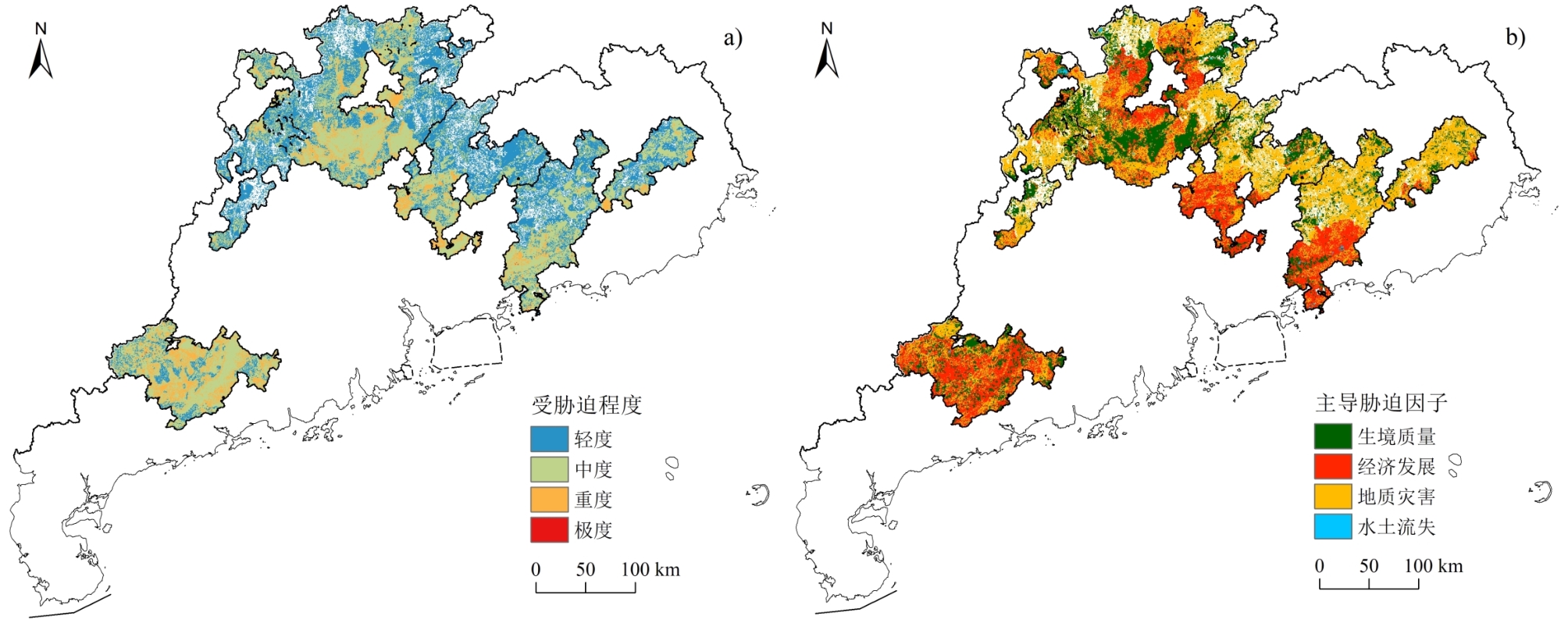
Biodiversity plays an important role in providing ecosystem services and maintaining ecosystem stability, which are closely related to human welfare. The identification of biodiversity hotspots and analysis of their threats provide effective ways for biodiversity conservation and restoration. Current studies generally combine species diversity and its threat situation to determine hotspots for priority protection. However, in-depth analysis of threats to biodiversity hotspots is still lacking. Guangdong Province is one of the key biodiversity areas in the world, but it faces great challenges in biodiversity preservation. To understand biodiversity hotspots and their threats in Guangdong Province more completely, this study developed a heat index for terrestrial biodiversity by considering plant species diversity, animal species diversity, and landscape diversity based on multi-source data of plant and animal species, ecosystem stand types, and land use. Then, the heat index was used to identify biodiversity hotspots, and their threat levels and controlling factors were analyzed according to the major threats to biodiversity. The results showed that areas with high values of terrestrial biodiversity heat index were mainly distributed in mountainous regions with relatively few human disturbances, whereas most areas with low values were concentrated in estuarine plains and intermontane basins with heavy human activities. Based on the zonation of the heat index, four biodiversity hotspots were identified, Yunwu Mountain, Nanling Mountain, Luofu Mountain, and Lianhua Mountain, with area percentages of 15.54%, 44.90%, 17.66%, and 21.90%, respectively. The area of biodiversity hotspots was 59,931.82 km2, accounting for 33.58% of the total land area of Guangdong Province. The 122 nature reserves within hotspots had an area of 6,594.39 km2, covering 61.33% of the whole area of the total 204 terrestrial nature reserves in Guangdong Province. This proportion gradually decreased with reduction of nature reserve grade, indicating that the nature reserves in hotspots were principally at a higher grade (nation and province levels) rather than at a lower grade (city and county levels). However, the area of these nature reserves in hotspots was only 11.00% of the whole area of hotspots, and most of the nature reserves that were not distributed in hotspots were located in the northeastern cities of Heyuan and Meizhou. Therefore, a large number of potential demands for biodiversity conservation still exist. For the four hotspots, the biodiversity in Yunwu Mountain was primarily under moderate to severe stress, with the intensity of economic development as the controlling factor. The biodiversity of the other three hotspots mainly underwent slight to moderate stress. The most important threat was the extensive economic development of the central part of Nanling Mountain and the southern parts of Luofu Mountain and Lianhua Mountain, whereas the periphery of Nanling Mountain and the northern parts of Luofu Mountain and Lianhua Mountain were more threatened by habitat quality or geological hazards. In addition, extreme stress on biodiversity occurred in all four hotspots, although within very small areas. Thus, more targeted management strategies for biodiversity should be proposed according to the stress levels and controlling threats. The results of this study provide a scientific reference for the comprehensive conservation and precise restoration of biodiversity hotspots in Guangdong Province.
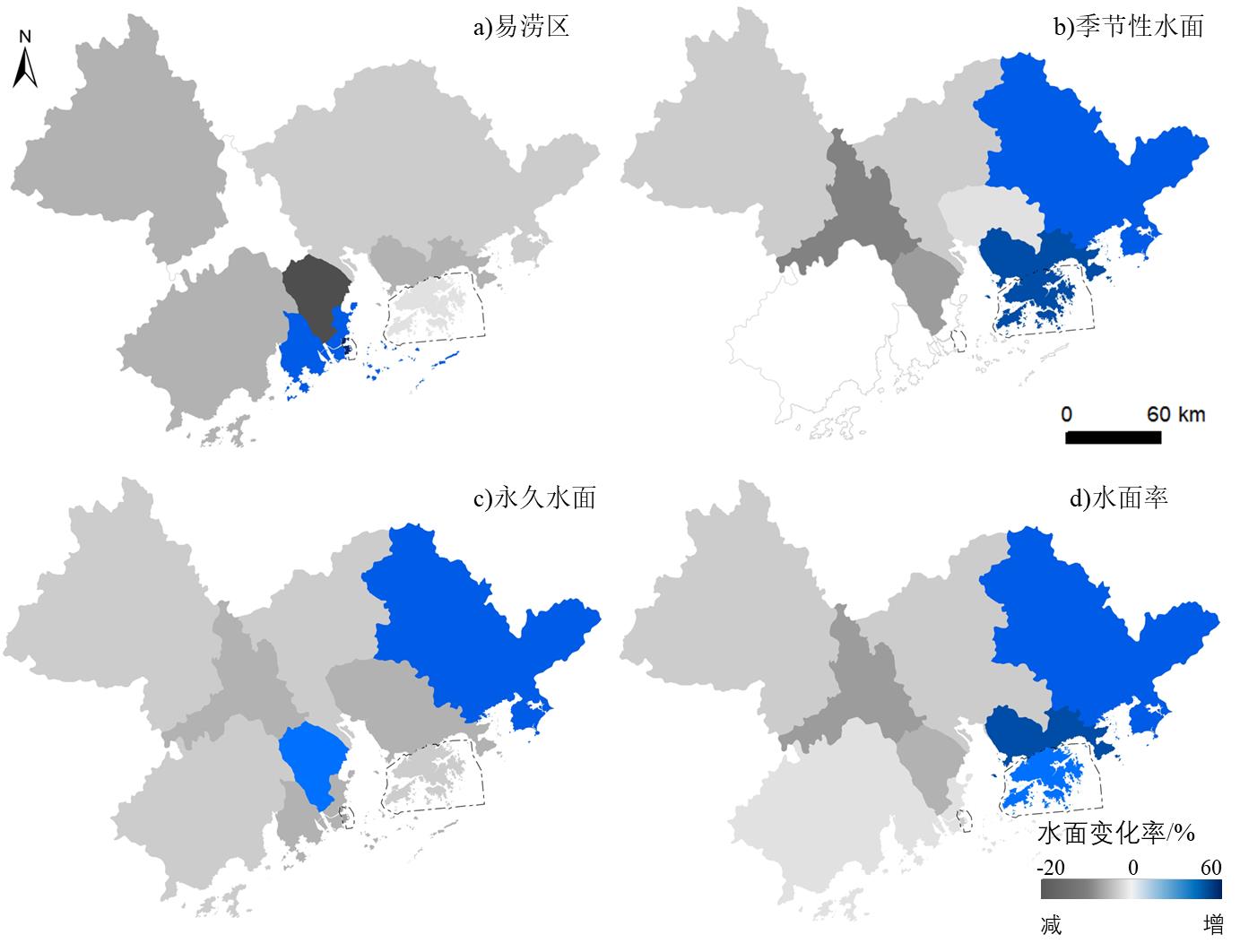
The distribution of surface water is highly dynamic both spatially and temporally, and very sensitive to climate change and anthropogenic interference, especially in highly urbanized regions. The abundance of surface water and its spatiotemporal distribution indicate the availability of water resources and the difficulty of water development and utilization. Consequently, it is essential to perform reconstruction and trend prediction of surface water body changes with high accuracy in time and space for scientific research as well as for practical purposes such as flood prevention, sustainable development of water resource systems, and regional ecological management. The Guangdong-Hong Kong-Macao Greater Bay Area (GBA) is highly developed economically and societally and is characterized by a subtropical humid monsoon climate with an extensive distribution of surface water bodies. Under the integrated pressure of continuous natural environmental change and intense human activity, concerns regarding both the water environment and water security in this area is increasing at an unprecedented rate. In this study, we collected water distribution information from 2001 to 2020 at 5-year intervals, as well as annual and monthly water extent dynamics data for the GBA from the Global Land Analysis & Discovery database. Subsequently, the spatial and temporal changes in water extent, frequency, and distribution characteristics in the last two decades were investigated using remote sensing and geographic information system methods. Finally, elastic analysis was conducted to identify the sensitivity of water body changes to changing environmental parameters, including precipitation, temperature, and urbanization. Focusing on the national and regional strategic needs of GBA, the research objectives of this study were to explore the mechanism of temporal and spatial dynamics of the water extent and frequency, trace the volatile areas of regional water changes, clarify the driving factors of water distribution changes, and provide a basis and guidance for comprehensive management of water resources, flood disaster prevention, and control in areas with high human activity. The first result shows that in the last two decades, the water extent and frequency of the GBA are on a decreasing trend, with an average decreasing rate of 50, 31, and 11 km2/a for maximum, annual, and permanent water extent, respectively, while a large proportion of seasonal water bodies changed into permanent and flood-prone bodies during the same period. Second, although the water frequency showed distinct spatial and urban/rural heterogeneity, it was on a decreasing trend in most of the GBA, except in the eastern region. A steeper decline was observed in urban areas, especially the emerging urban regions. Third, the dike-pond system decreased both in water extent and frequency, while the large and medium-sized lakes and reservoirs in the upper catchment increased in extent. Finally, elastic analysis suggests the dominant driving factor of regional water body change is land use change, which contributed more than 80% to the decrease in water extent, and the reservoir increase is mainly due to precipitation change. The results of this research provide scientific guidance for regional water resource guarantee, water environment optimization, and sustainable development promotion. In addition, this research can serve as a decision-making reference for the development of the "One Belt One Road" national strategy and Guangdong-Hong Kong-Macao Greater Bay Area.
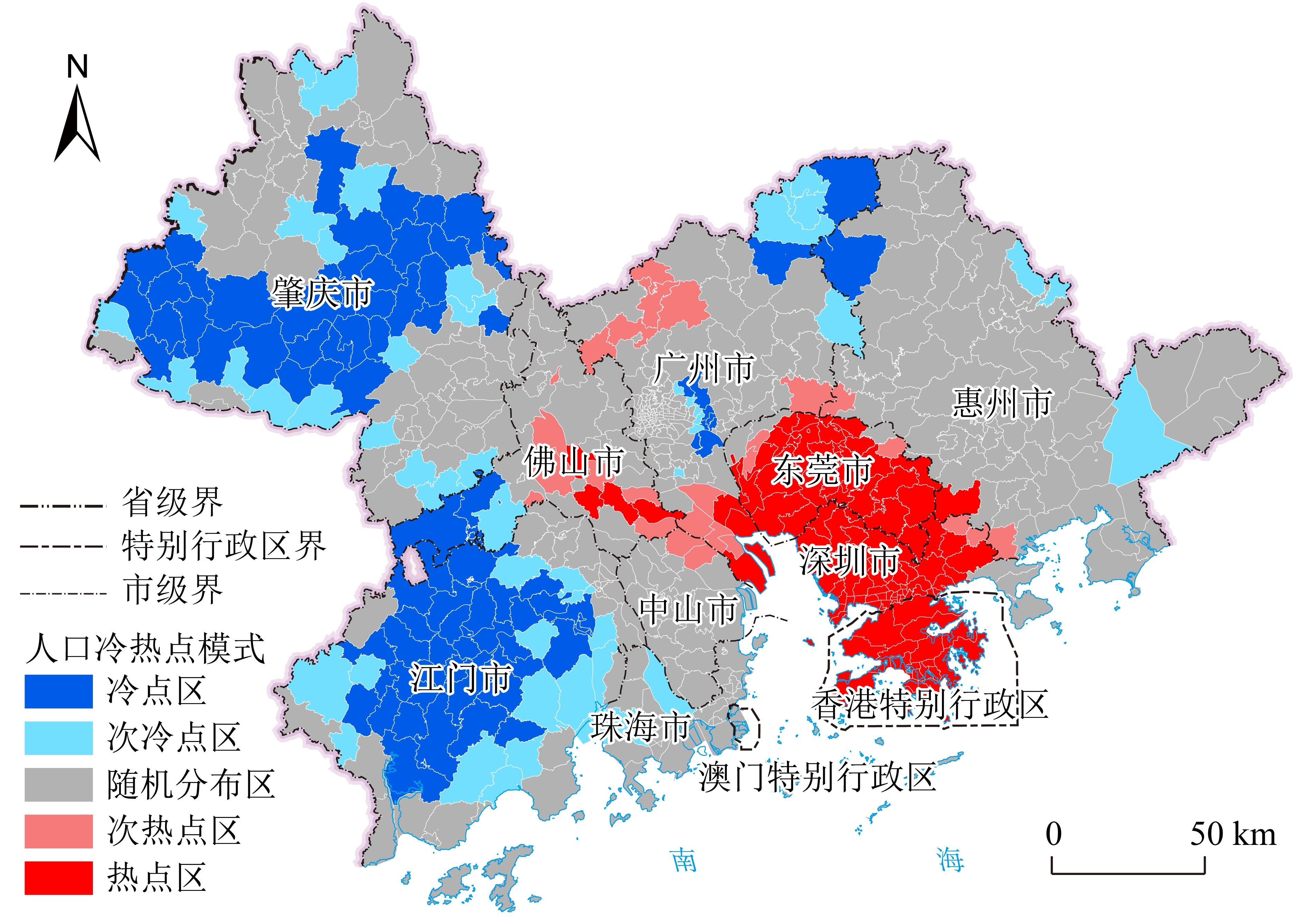
The Guangdong-Hong Kong-Macao Greater Bay Area (GBA) is one of the most open regions in China, with the strongest economic vitality and fastest population growth, playing an important role in China's development strategy. Using GBA as the research area, Luojia1-01 radiance images and high-precision land type data from 2022 were merged to obtain the noctilucent index of land fusion. Stepwise regression models based on district-level administrative divisions were constructed and their accuracy was verified. Finally, the 500 m spatial distribution characteristics of the population for the GBA in 2020 were analyzed from multiple perspectives, including population size and density, spatial directivity, spatial agglomeration degree, and dispersion characteristics. The results show the following: 1) the integration of Luojia1-01 radiation brightness value and high-precision land type data guaranteed population spatialization accuracy, while scattered population agglomeration points could be identified by Luojia-01, and details of population distribution in the image saturation zone could be distinguished by land type data; 2) Population quantity and density had a highly synergistic spatial distribution relationship with five population agglomeration areas in the GBA, with sparse population in marginal cities. The population scale decreased outward from the accumulation regions; 3) Population distribution presented significant spatial directivity along the Guangzhou, Dongguan, Shenzhen, and Hong Kong directions, which proved that the economic level is an important factor affecting the spatial distribution of the population. Regional coordinated development in emerging economies was obvious among these cities along the direction, thus attracting population migration and agglomeration; 4) The population agglomeration feature was remarkable in this area, with 68% of the population concentrated within 27.64% of the spatial range. Popular hotspots were located in the regions of Dongguan, Shenzhen, and Hong Kong, with cold spot areas mainly distributed in Zhaoqing and Jiangmen. Population intensity was excessive in Tianhe, Yuexiu, and Haizhu Districts of Guangzhou City, and policy intervention is urgently needed for these districts to mitigate population pressure and improve the living environment, thus promoting regional coordinated development. The results of this study prove that Luojia-01 data are capable of population research at the municipal administrative division level. The revealed spatial distribution characteristics of the population have reference significance for urban policy formulation, planning management, and coordinated development in the Greater Bay Area. There are also some shortcomings in this study, such as the lack of population distribution exploration due to the limitation of satellite acquisition and a decrease in the accuracy of population spatialization results due to spatial-temporal inconsistency in the data. Further studies are needed to improve the accuracy and reveal additional features of the population spatial-temporal distribution in a long-term series.
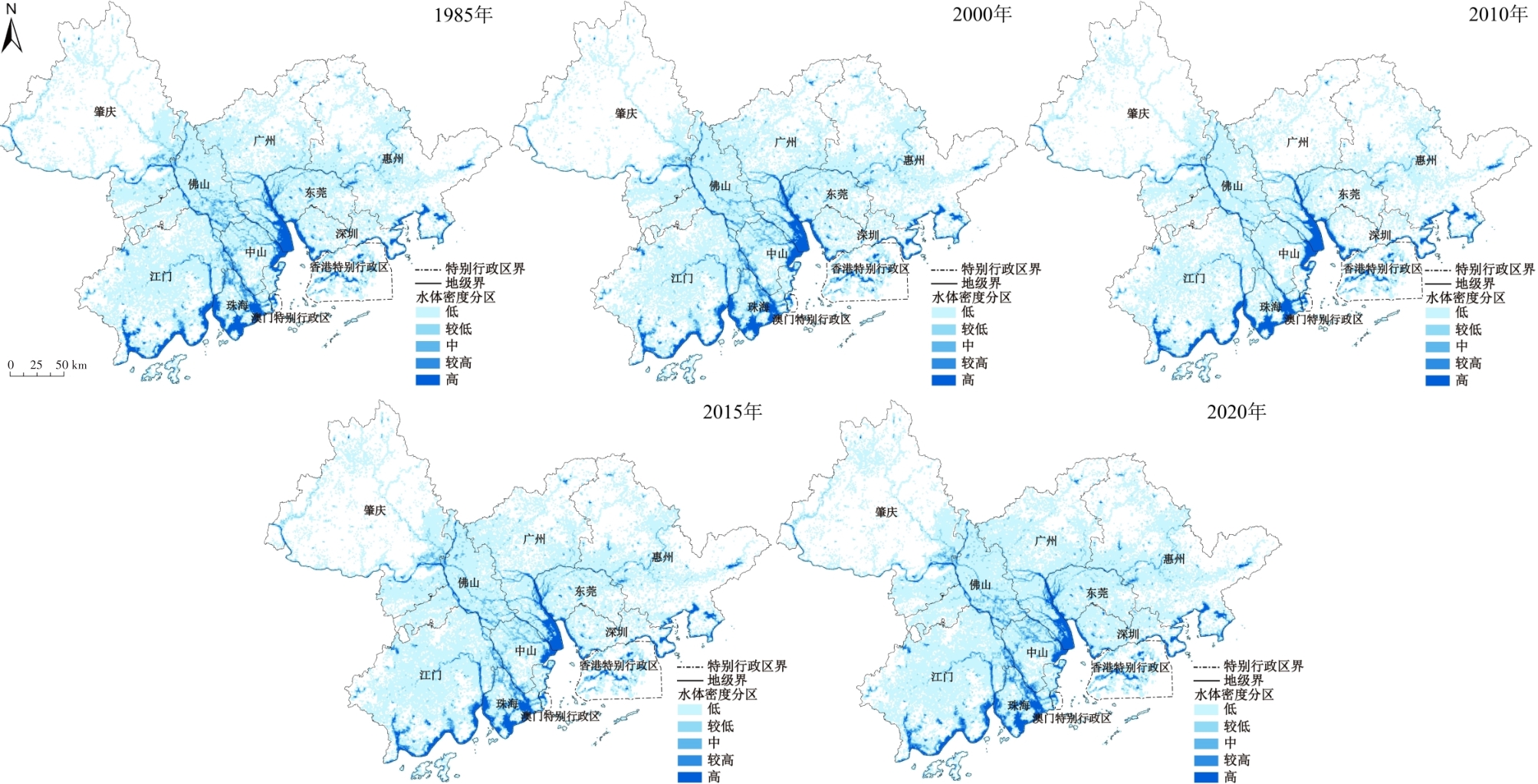
Surface water is an important water resource required for all living things on Earth and the basic resource for human production and living, having great value to mankind. Based on the GEE and ArcGIS platforms, this study uses the global annual surface water dataset from 1985 to 2020 as the main data source and analyzes the spatial and temporal evolution of surface water bodies in the Greater Bay Area (GBA) using the rate of water area change, the density of gridded water bodies, and the land use conversion matrix. We then investigate the relevant influencing factors driving the spatial and temporal evolution of surface water bodies with the assistance of the Geographic Detector. Based on the above findings, and combined with urban development policy and regional development orientation, the spatiotemporal evolution mechanism of surface water bodies in the GBA over the study period was analyzed from the perspective of urbanization development laws. This analysis is also the primary contribution of the study and is the key difference between this research and previous pure geography studies. The results indicate the following: 1) The area change rate of surface water bodies in the GBA shows the characteristics of "slow decline - accelerated decline - deceleration - steady increase;" therefore, the study period is divided into slow shrinkage(1985-2000),accelerated shrinkage(2000-2010),deceleration shrinkage (2010-2015), and steady growth(2015-2020) based on these stage characteristics; 2) The change in the permanent water body area in the GBA has the periodic characteristics of "small cycles of alternating increases and decreases," while the seasonal water bodies area show the change characteristics of "largely decreased first and then increased." The influence of the two types of water bodies on the changes in the total surface water body area shows the characteristics of "alternative domination" with 2010 as the time node; 3) Spatially, large changes in surface water bodies appear in the form of urban clusters. For example, regional urban agglomerations, such as Fo-Guang-Zhao, Shenzhen-Guan-Hui, and Zhu-Zhong-Jiang, show synchronous shrinking or growth in the evolution of water bodies. This is mainly due to urban agglomerations being caused by the transfer (including migration in and out) of land types, such as water bodies, urban construction land, and cultivated land at different periods of urbanization development; 4) From the perspective of the entire study period, natural factors had higher explanatory power for the spatial differentiation of surface water bodies in the GBA than social and economic factors. The explanatory power of annual precipitation and vegetation coverage factors reached 40% and 34%, respectively. There was a two-factor enhanced interaction relationship with multiple factors, among which the explanatory power of cultivated land density and population factors was 31% and 30%, respectively, and there was a non-linear enhanced interaction relationship with multiple factors; and 5) From the perspective of the urban development period, the degree of influence of natural, social, and economic factors on surface water bodies varies across different stages. Natural factors played a leading role in the temporal and spatial differentiation of surface water bodies during the early urbanization process. As urban development accelerated and entered a stable period, the influence of human activities on surface water bodies increased rapidly and became an important driving force for temporal and spatial differentiation.
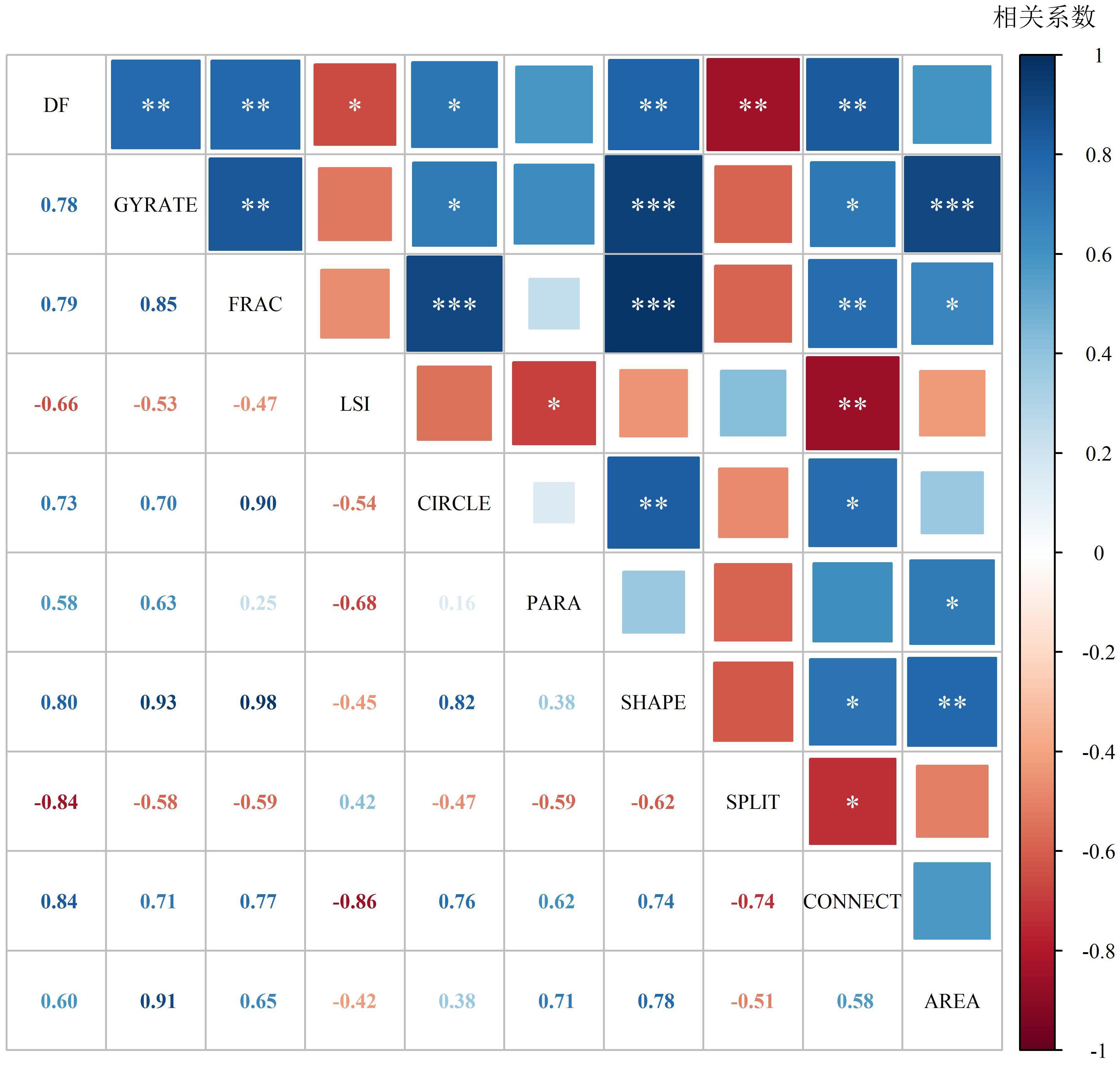
With the advancement of urbanization in China, hilly and gently sloping mountainous areas have become areas of high disturbance owing to urban construction, with the disturbed areas also having a high incidence of mountain disasters. The large hilly and shallow mountainous areas in the Guangdong-Hong Kong-Macao Greater Bay Area are continually disturbed by rapid urbanization, with frequent geological disasters. This study attempts to reflect the boundary morphology of the interaction zone from the perspective of the landscape morphology of the town-mountain interaction zone by using the landscape pattern index, analyzing the relationship between the morphological index and the intensity of geological disasters, and identifying the key factors. Finally, the functional relationship is fit between the intensity of disasters and the landscape pattern index based on the GAM model to reveal the interaction characteristics of towns and mountains and the disaster effects caused by them. The results of the study show that: 1) the urban-mountain interaction zone in the Bay Area is located in Guangzhou, Shenzhen and Hong Kong, with an area of 131.8, 81.6 and 58.5 km2 respectively, primarily in areas with a high proportion of hilly and shallow mountainous areas and rapid urban development; 2) Shenzhen and Hong Kong had higher landscape pattern indices than other regions, while Jiangmen, Zhaoqing, Foshan, and Huizhou generally had a lower landscape pattern index; 3) Among the nine landscape pattern indices, seven were positively correlated and two were negatively correlated, with CONNECT showing the highest correlation of 0.84 (P<0.001), SPLIT showing a high negative correlation of -0.84 (P<0.001), and AREA and PARA showing a weak correlation; 4) Most of the edge indicators, shape indicators, and agglomerative landscape index had linear relationships with landslide hazard frequency, and the frequency decreased with an increase in LSI and SPLIT and increased with the increase in GYRATE, SHAPE, FRAC, PARA, and CIRCLE; and 5) The larger the area of the urban-mountain interaction zone, the more complex the shape; the longer the boundary length, the more irregular the shape of the interaction zone; and the smaller its closeness to a circle, the more fragmented the interaction zone patches, the higher the ratio of core patches to the total area of the interaction zone, and the higher the probability of landslide disasters. Combined with the results, from the perspective of the construction of a single project in a small area, the larger the scope of excavation to the mountain, the more tortuous and complex the engineering cut, and the higher the probability of triggering landslides and collapses. For large-scale continuous construction projects, the closer the cuts are to each other, the higher the degree of agglomeration, the larger the area occupied by the core project, and the more likely it is to trigger geological disasters. This study is significant for understanding and mastering the heterogeneity law of geological hazards under different land use degrees and configuration measures, which can serve as a guide for land structure adjustment and optimize land use layout more effectively. It is of great practical significance for ecological restoration, sustainable and rational use of land resources, geological hazard prevention and control, and enriches the geological hazard susceptibility evaluation system.
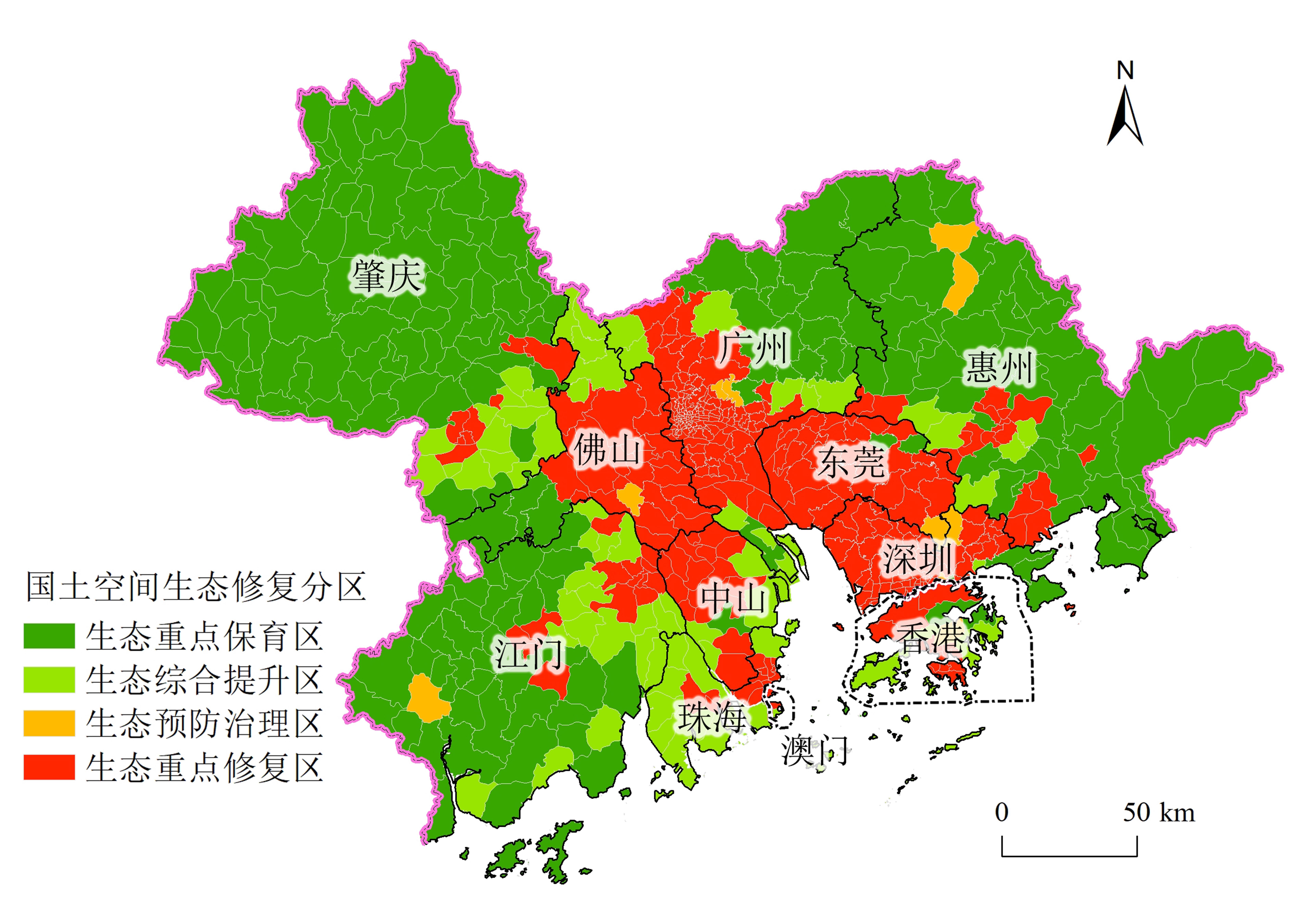
Territorial spatial ecological restoration zoning is an important basis for implementing differentiated protection and restoration strategies and an important premise for promoting the integrated protection and restoration of mountains, rivers, forests, fields, lakes, and grasses and regional coordinated governance. In the current research on territorial spatial ecological restoration zoning, less attention is paid to human demand for ecosystem services and territorial spatial ecological restoration zoning from the perspective of the supply and demand of ecosystem services. As a result, zoning is unable to solve the contradiction between human and land relations, which has a certain impact on the implementation of subsequent restoration projects. Therefore, from the perspective of ecosystem service supply and demand, this study considers the Guangdong-Hong Kong-Macao Greater Bay Area as the research area, scientifically delimiting the territorial space ecological restoration zones of the Guangdong-Hong Kong-Macao Greater Bay Area and proposes differentiated protection and restoration strategies for each zone. The results show that the spatial distribution of the comprehensive supply and demand of ecosystem services in the Guangdong-Hong Kong-Macao Greater Bay Area has a strong spatial heterogeneity. The comprehensive supply capacity mainly presented a spatial distribution pattern of high in four weeks and low in the middle, and the comprehensive demand presented a spatial distribution pattern of high in the middle and gradually decreasing from the ring to the periphery. There are many towns/streets with a spatial mismatch of supply and demand of ecosystem services (low supply and high demand; high supply and low demand), accounting for approximately 85% of the total area. There are relatively few towns/streets with spatial matching (high supply and high demand; low supply and low demand), accounting for approximately 15% of the total area. However, in space, there is a trend that the internal low-supply and high-demand areas gradually transition to the external high-supply and low-demand areas in a semicircle. According to the matching of supply and demand of ecosystem services, the Guangdong-Hong Kong-Macao Greater Bay Area was divided into four zones, and a differentiated protection and restoration strategy was proposed for each zone. In general, the key ecological conservation areas (61%) focus on nature conservation and pay attention to the maintenance of regional ecological integrity and biodiversity; the comprehensive ecological improvement zone (13%) is mainly composed of auxiliary restoration and ecological reconstruction, focusing on strengthening the construction and restoration of the suburban ecological buffer zone; the key ecological restoration areas (24%) mainly focus on auxiliary restoration and ecological remodeling to improve the ecological resilience of the area, while ecological prevention and control areas (2%) focus on nature conservation, maintaining the current ecological situation and ecological supply capacity, and preventing ecological environment degradation.
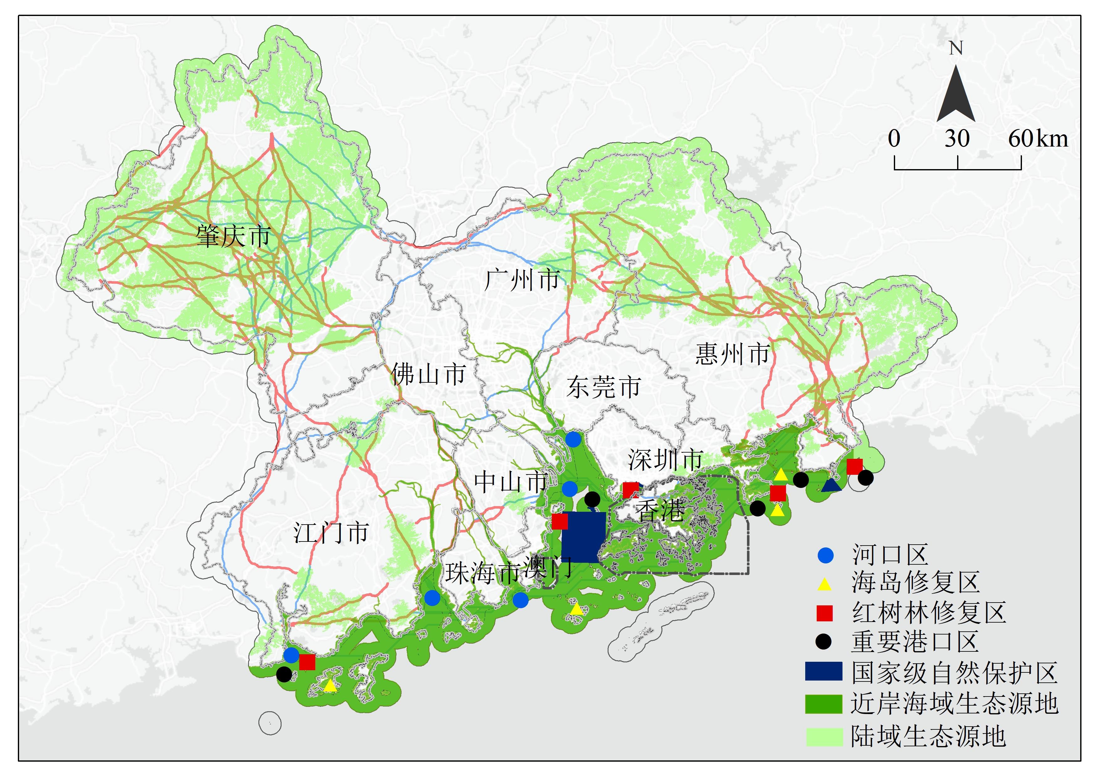
Territorial space ecological restoration has become a significant strategy for the construction of China's ecological civilization. It is also an important strategic task related to national ecological security and human well-being. The continuous expansion of space in urban agglomerations and the high-intensity development of cities have exacerbated the fragmentation of natural landscapes. The ecological security of urban agglomerations and the ecological restoration of territorial spaces have become key issues of common concern to the government and scholars. Currently, the research on ecological restoration of territorial space mostly focuses on the identification of ecological restoration areas based on the key components of ecological security patterns and rarely discusses the coordinated protection and restoration of urban agglomerations by combining the ecological security patterns with human activities. It is particularly necessary to identify the ecological restoration areas and build a technical paradigm for ecological protection and territorial space restoration that can provide a basic support for the ecological integration, construction, and sustainable development of urban agglomerations. Based on ecological network construction and human disturbance assessment, this study diagnoses the territorial space ecological restoration areas of Guangdong-Hong Kong-Macao Greater Bay Area and proposes ecological protection and restoration strategies for the territorial space ecological source restoration area, ecological corridor restoration area, and stepping stone restoration area. The results showed that: (1) Human activities in the Guangdong-Hong Kong-Macao Greater Bay Area had high interference intensities and a wide impact on the ecological environment; areas with high and relatively high interference accounted for 48.65% of the total area, mainly concentrated in the central part of the Greater Bay Area. (2) The ecological network of Guangdong-Hong Kong-Macao Greater Bay Area presented a relatively stable characteristic pattern of "2 breadth lines and 4 length lines". The 2-breadth lines included the continuous mountains in the north and the ecological protection belt of the southern coastal waters. The 4-length lines included the eastern and western land corridors and the central water corridors. (3) The ecological source restoration area of the Guangdong-Hong Kong-Macao Greater Bay Area was 4,687.42 km2, the ecological corridor restoration length was 1,362.71 km, and the stepping stone restoration area was 833.82 km2, mainly distributed in Zhaoqing, Huizhou, and Jiangmen. To limit human disturbance and restore ecological functions, strategies for territorial space ecological restoration were proposed based on the ecological network function and structural integrity; (4) It is urgent for government departments to overcome the concept of regionalism and build a consensus on the co-disposal of ecological restoration in the territorial space. The construction of cross-domain collaborative governance institutions will efficiently promote the ecological restoration of cross-regional territorial spaces. Considering both human and ecological systems, this study discussed the ecological restoration schema in key areas of ecological networks, coastal ecological restoration areas, and trans-regional ecological restoration areas. The method for urban agglomeration territorial space ecological restoration was formed, including "ecological network pattern-human activity disturbance-restoration area diagnosis-restoration strategy," which will provide a framework for promoting the territorial space ecological protection and restoration in the Guangdong-Hong Kong-Macao Greater Bay Area.
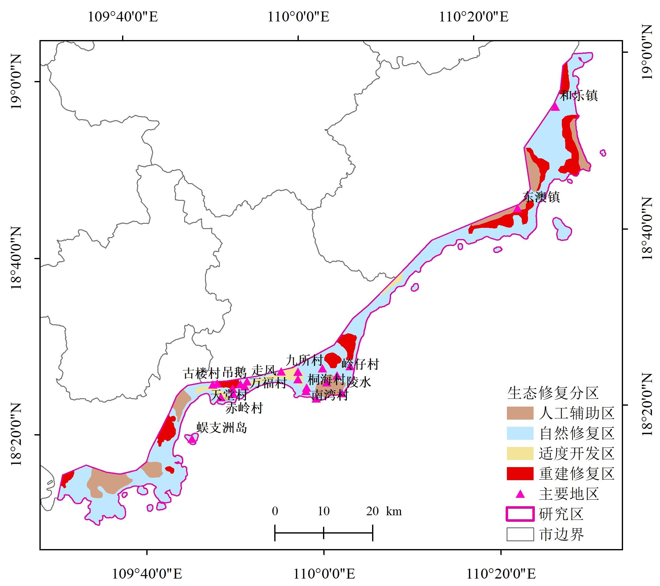
Carbon peak and neutralization, land space ecological restoration, and sustainable management of sea areas and islands are all important components of national development strategies. In recent years, owing to the impact of natural factors, human interference, and global climate change, the ecosystem of the southeast coast of Hainan has been seriously damaged, and its carbon sink function has decreased significantly. This decline in the ecological quality of the southeast coast of Hainan is inconsistent with the positioning requirements of the Hainan Free Trade Port and the National Ecological Civilisation Construction Pilot Zone. Thus, ecosystem restoration based on carbon storage needs to be urgently explored. Using the southeast coast of Hainan Island as an example, the carbon storage module based on the InVEST model, combined with the land use data of the study area in 2000, 2010, and 2020, the carbon storage of the study area was estimated. The carbon sink and carbon source areas were divided, and the carbon storage function was evaluated. Over the past two decades, carbon loss in the study area has been identified, and areas with serious carbon loss were identified, with the ecological restoration functional area divided. The results showed that the ecosystem in the study area was damaged to varying degrees, decreasing by 1.11 Gt over 20 years. Traditionally, the area of the carbon source is always larger than that of the carbon sink. Areas with poor and extremely poor carbon storage functions were 39.84 and 27.31 km2, respectively. According to the superposition results of the carbon storage function and terrestrial ecosystem service value, four restoration units (natural restoration area, artificial auxiliary area, reconstruction restoration area, and moderate development area) were selected. In light of the different restoration areas and under the guidance of land space planning and the idea of carbon neutral and carbon peaks, ecological restoration strategies, including rehabilitation and restoration of wetlands, shoreline restoration, wetland reconstruction, and strengthening supervision, have been proposed in a targeted and differentiated manner. The research results have important reference value for strengthening the protection of the restoration area in the southeast coastal zone of Hainan, stabilizing the carbon storage capacity, reversing the trend of carbon loss, and realizing effective protection and restoration of the damaged ecosystem. Furthermore, the ecological service function and quality of coastal zones, and the marine ecological compensation mechanism, can be further improved.
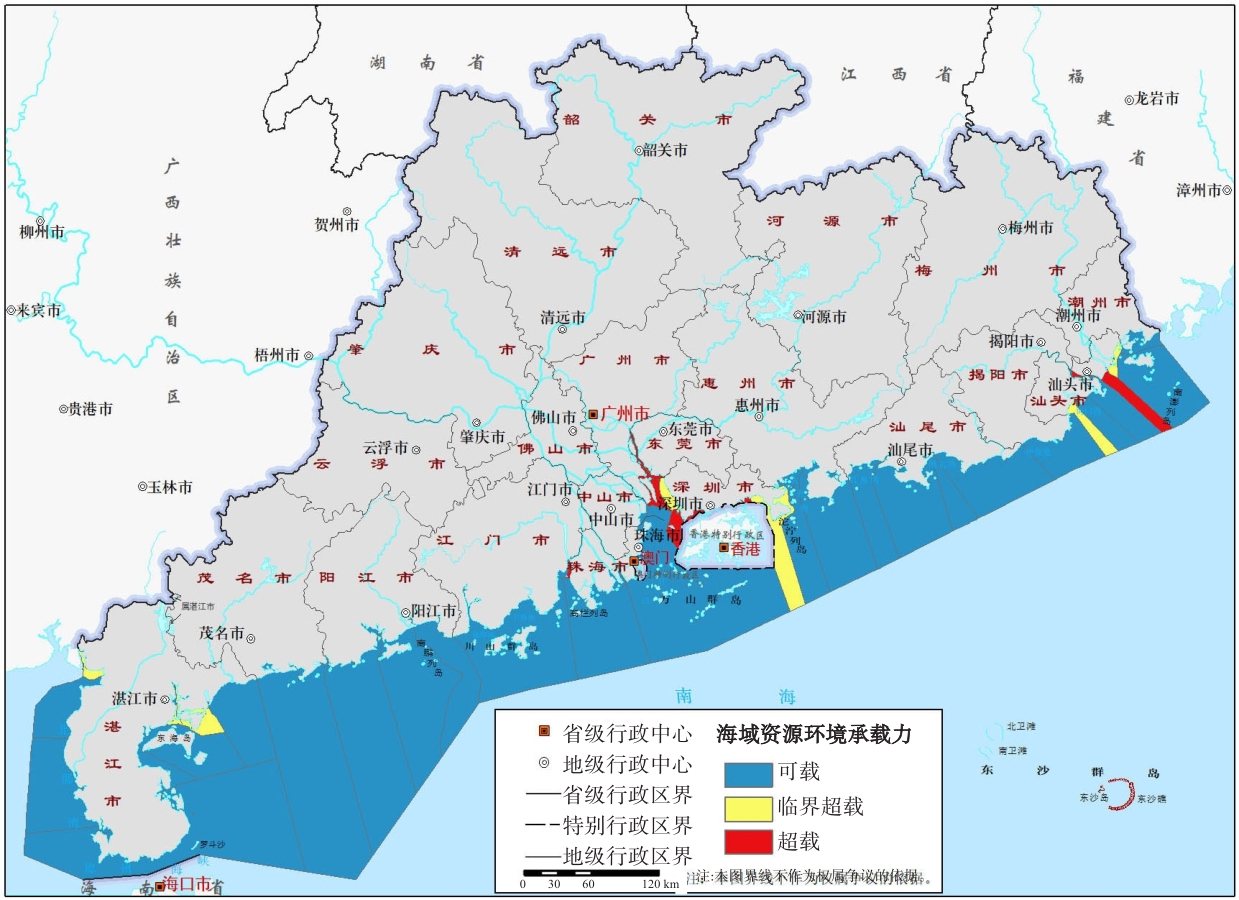
Guangdong Province is actively building a national marine ecological civilization construction demonstration area, and it is crucial to conduct research and assessment on the resources and environmental carrying capacity of the coastal zones. Under the guidance of the "double evaluation" of the territorial space planning, this study takes the coastal areas of Guangdong Province, namely the 45 coastal counties and the sea areas within the scope of the marine functional areas of Guangdong Province as the research scope It proceeded from the functional orientation of ecological protection, agricultural production, and urban construction to construct the evaluation index system of the resources and environmental carrying capacity of the coastal zone of Guangdong Province. In 2019, based on the evaluation index system, a comprehensive evaluation of the resources and environmental carrying capacity of the coastal zone of Guangdong Province was performed using integrate and integrate multi-scale spatial data, remote sensing, geographic information system, and other technical means and its resource and environmental carrying status were quantitatively revealed. The results showed that approximately 84% of the land area in the coastal zone and more than 1/2 of the sea areas (cities, districts) have overall good comprehensive bearing status of the resources and environmental carrying capacity, which is mainly characterized by loadability. The scale of human socio-economic activities in most regions is within the range of the resources and environmental carrying capacity; however, in some regions it exceeds the threshold, particularly in regions distributed in the Pearl River Delta. Specifically, under the guidance of the ecological protection function, 60.05% of the land area and 14 counties (cities, districts) of the sea area are in a loadable state, mainly distributed in the east and west wings of the urban agglomeration in the Greater Bay Area of Guangdong, Hong Kong, and Macao. Under the guidance of the agricultural production function, the carrying capacity of land agriculture is relatively severe, mainly critical overload, while the number of counties (cities, districts) that can be carried by sea agricultural production is relatively small. Compared with the functions of ecological protection and agricultural production, the area of the loadable area under the urban construction function is the highest, with 86.93% of the land area and 29 counties (cities, districts) of the sea area in the loadable state, and only 3.01% of the land area and 10 counties (cities, districts) of the sea area in the overloaded state. Guangdong Province is a major province of marine economy. As an important place for economic activities in the coastal zone, the ocean is a strategic place to promote the high-quality development of Guangdong Province.. Under the mode of sustainable development, there is still a large scope for the development of resources and environmental carrying capacity in the coastal zone of Guangdong Province. On the premise of ensuring the stability of resources and environment, the loadable area can be further developed and utilized selectively, the allocation of resource elements can be optimized, and a new management mode of high-level protection and efficient utilization of resources can be built. Thus the research results provide a basis for the compilation of territorial space planning and the optimization of territorial space development and protection pattern in Guangdong Province.
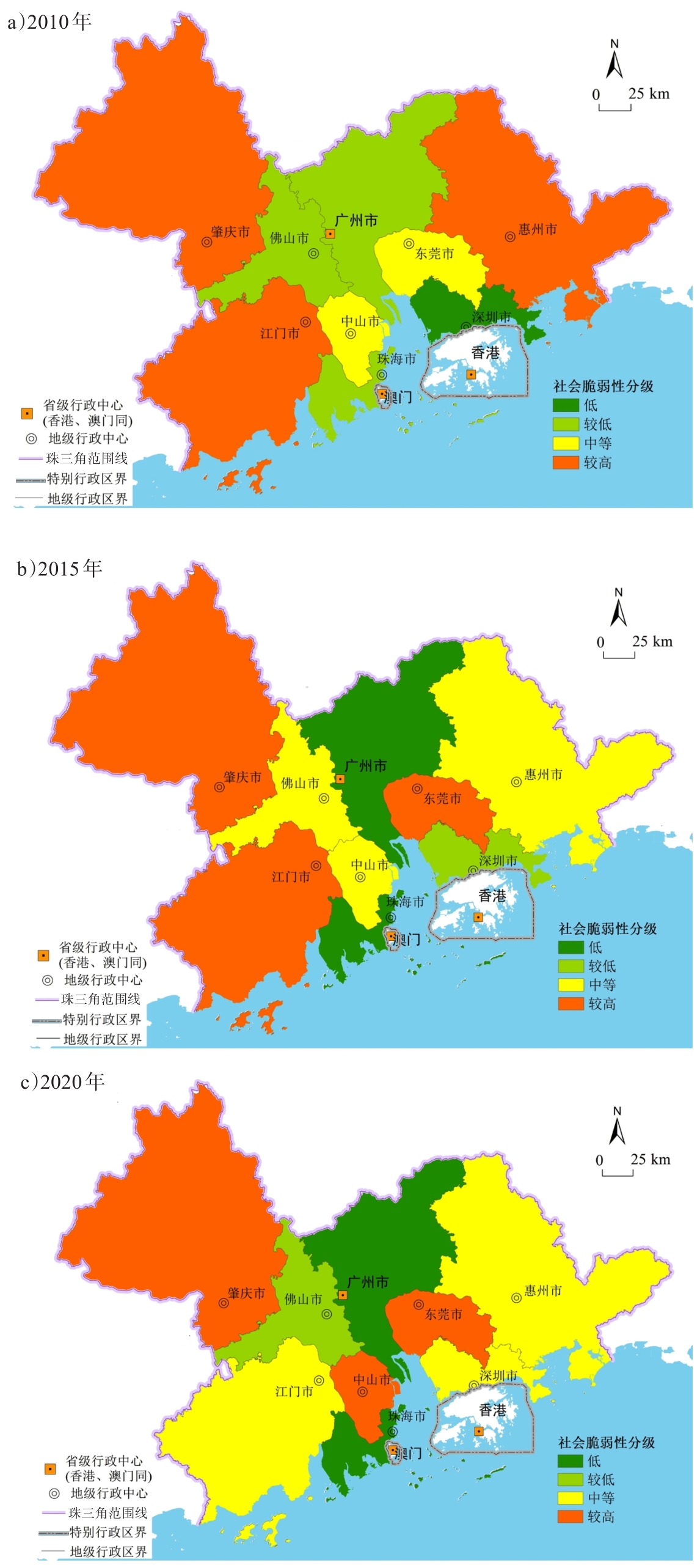
The Pearl River Delta urban agglomeration is located in the sensitive zone of the Pearl River Delta estuary. Here, natural conditions are complicated, human activities are strong and natural disasters such as typhoons, floods, landslides, debris flow, ground settlements, and ground collapses are frequent that have caused severe damage to urban operations, property, and transportation, and a threat to human safety. Therefore, improving the ability of the Pearl River Delta urban agglomeration to deal with natural disasters and its resilience is one of the important issues that need to be resolved in urban development and construction. This study examined the social vulnerability of the Pearl River Delta urban agglomeration from the perspective of disaster prevention and mitigation and proposed several optimization strategies to reduce social vulnerability. Firstly, an urban disaster social vulnerability evaluation index system was established based on four aspects: population, economy, infrastructure, and social organization guarantee. Secondly, based on the information entropy method of objective empowerment, a quantitative evaluation model of social vulnerability was established, the vulnerability index of the Pearl River Delta urban agglomeration was calculated, and the law of vulnerability and its influence on the evolution of social vulnerability in various cities were analyzed. Finally, optimization suggestions were proposed to reduce social vulnerability, based on a demanding perspective. The results showed that the average social vulnerability index of nine cities from 2010 to 2020 showed a trend, which initially increased and then decreased. The social vulnerability index changed significantly for each city and no significant rule was evident. Guangzhou had the lowest social vulnerability, whereas Zhaoqing had the highest. Moreover, in 2010, the level of social vulnerability in Shenzhen was low; Guangzhou, Zhuhai, and Foshan were relatively low; Foshan, Dongguan, and Zhongshan were medium, and Huizhou, Jiangmen, and Zhaoqing were high. In 2015, the level of social vulnerability in Guangzhou and Zhuhai were low; Shenzhen was relatively low; Foshan, Huizhou, and Zhongshan were medium, and Jiangmen, Dongguan, and Zhaoqing were high. In 2020, the level in Guangzhou and Zhuhai were low; Foshan was relatively low; Jiangmen, Shenzhen, and Huizhou were medium; and Zhongshan, Dongguan, and Zhaoqing were high. In addition, the factors affecting the social vulnerability of each city were significantly different; however, economic vulnerability and social organization security vulnerability were the main factors. By scientifically formulating urban spatial planning five perspectives were proposed: conducting scientific assessments of urban resilience level, promoting the construction of urban resilience systems, promoting the integration of blue, green, and grey disaster prevention infrastructure, establishing urban agglomeration disaster prevention and resilience management systems, and optimization strategies for promoting resilience of the Pearl River Delta urban agglomeration. The selection of a natural disaster social vulnerability evaluation index system for urban agglomeration is subjective and uncertain; this aspect was also realized during the selection of the index system for this study's Pearl River Delta urban agglomeration. Therefore, the next step is to further improve the evaluation index system. In addition, a comparison of supplementary verification data or multi-data evaluation methods will be used to further improve the results of the social vulnerability assessment of the Pearl River Delta urban agglomeration. The results of this study can provide a scientific basis for improving the comprehensive disaster prevention and mitigation capacity and resilience of the Pearl River Delta urban agglomeration.
Evapotranspiration is an important mechanism connecting earth surface and the atmosphere. One of the factors that affect regional transpiration include land cover type. With the speeding up of urbanization around the world, urban land cover change and its impact on surface evaporation have attracted extensive attention from academia. The change in land cover in Guangzhou China, which occupies the central area of the Pearl River Delta Urban Agglomeration, is more diverse and complex during a certain period. This can be attributed to the rapid urbanization of Guagnzhou since the reform and opening up of China. The urbanization process of Guangzhou is typical, and research findings from this study can be referred to ensure rational allocation of water resources and construction of sponge cities during the urbanization process of other large cities. The present study investigated the changes in land cover and urban green space structure in Guangzhou over the last two decades; this was based on the remote sensing interpretation of Landsat datasets for 2000, 2005, 2009, 2015, and 2020. Data were obtained from 38 meteorological stations in Guangzhou and its surrounding areas; thereafter, spatial interpolation of the data was conducted to assess the change in trends of precipitation, temperature, air pressure, wind speed, and relative humidity over the past 20 years. After the above two steps, the change of surface evapotranspiration in Guangzhou was investigated. The obtained results suggested are given below:1) The total area of urban green space in Guangzhou decreased during 2000-2020. The change in land cover was mainly characterized by a significant conversion of non-forest vegetation into construction land or unused land, such as urban residential, industrial, and commercial land. Some of the vegetation had also been converted into forest land. In the past 21 years, the proportion of forest land in the urban greenspace ecosystem of Guangzhou has shown an upward trend. 2) The proportion of forest land and annual average evapotranspiration in Guangzhou showed an overall upward trend during 2000-2020. The annual average evapotranspiration and proportion of forest land were positively correlated. Moreover, high spatial consistency was observed between the increase and decrease in evapotranspiration and the mutual transformation between land cover types with different evapotranspiration capacities. 3) During the study period, evapotranspiration in Guangzhou was positively correlated with precipitation, relative humidity, and temperature and negatively correlated with air pressure, sunshine hours, and wind speed. However, the area proportion of regions with significant or higher correlation between meteorological factors and surface evapotranspiration was too low to indicate that meteorological factors were the main driving factor behind increasing regional evapotranspiration. 4) The increase in surface evapotranspiration in Guangzhou from during the study period did not occur synchronously with the spatial changes of the urban green space ecosystem and showed a lag owing to different reasons, including forest growth cycle and climate conditions. In conclusion, the study summarized the land cover changes and achievements of urban green space ecological construction under the process of urbanization in Guangzhou and explored the comprehensive impact of land cover change on regional surface evapotranspiration in Guangzhou over the last 20 years. This study provides a theoretical basis and data reference for urban ecosystem management in Guangzhou.
With regard to China's vigorous promotion of environmental governance and ecological restoration, farmers around mines are victims of environmental damage and major participants in ecological restoration. Their willingness to participate is related to whether the government's environmentalpolicies can play a good role. This study developed a structural equation model of the impact of environmental perception on pro-environmental behavior willingness and conducted an empirical study using survey data of farmers around the Dabaoshan tailings area in Shaoguan in 2020. Value perception includes "economic value" and "ecology value", which was measured by the two observable variables "increasing income" and "improving the surrounding environmental quality". The results showed that value perception had a positive impact on farmers' willingness to be environmentally friendly, and that the standardization coefficient of the "increase in income" variable was higher, which meant that if farmers felt that environmental governance in the tailings area could bring them economic benefits or improve the ecological environment, they were more inclined to participate in environmental governance activities in tailings areas, and local farmers paid more attention to economic interests. Endowment perception represented farmers' self-efficacy, which was measured by "energy perception" and "ability perception". The above two variables strongly influenced farmers' willingness to be pro-environmental. The results showed that the higher the self-efficacy evaluation of farmers, the stronger their willingness to participate in environmental governance of the tailings area. Policy perceptions including exemplary norms and command-line norms were measured by "government attitudes", "attitudes of miner" and "attitudes of neighbor and friend". The results showed that policy perception had a direct impact on farmers' willingness to pro-environmental behavior, but this was due to an indirect impact by affecting farmers' value perception and policy perception, and "mining enterprise attitude" was the policy perception where the important variables were explained. Therefore, improving farmers' value perception and endowment perception through policy perception could also indirectly improve their willingness to exhibit pro-environmental behavior. Based on the above results, this study puts forward relevant policy implications. First, traditional media, newspapers, and TV should combine with emerging online platforms such as Douyin and Kuaishou to expand publicity channels. As rational economic people, farmers naturally attach great importance to the value brought about by participating in environmental governance in tailing areas. Therefore, it is necessary to publicize the economic and ecological value of environmental governance in the tailings area in a simple and easy-to-understand way and to make the publicity more targeted. Second, it is necessary to strengthen employment guidance and vocational education, improve the technical literacy of local farmers, lower the threshold and cost for farmers to participate in environmental governance, and encourage them to make scientific decisions. Last but not the least, it is necessary to build an ecological restoration exchange platform, strengthen the demonstrative role of neighborhoods, break the information barriers between the government and farmers, and explore effective leading models.
After more than thirty years of rapid development, China has made great social and economic progress; however, this has inevitably damaged the ecological environment. The ecological environment is the foundation of human survival and development. With the development of social economy and the improvement of living standards, the demand for a better ecological and living environment is increasing. Therefore, ecological restoration of territorial spaces of mountains, rivers, forests, farmlands, and lakes, providing a good ecological and living environment for the people, and building a beautiful China has become necessary to promote the harmonious coexistence of humans and nature while achieving modernization. In terms of theory and method, ecological restoration of territorial space is a new discipline. In recent years, many scholars have proposed various theories, technologies, and methods of ecological restoration from the perspectives of traditional ecology, geography, planning, and other disciplines. Ecological restoration practices are supported by national policies and promoted by the people's needs, and numerous ecological restoration projects have been carried out across the country in recent years. These include the practice, verification, and exploration of ecological restoration theories. However, because these projects are scattered across different departments, provinces, cities, or regions, they are difficult to summarize and evaluate uniformly. Under the guidance of the Guangdong Provincial Department of Natural Resources, two rounds of selection of ecological restoration examples were conducted in Guangdong in 2019 and 2021, wherein the ecological restoration projects carried out by different cities and departments in Guangdong Province in recent years were reviewed and evaluated. Based on the analysis and evaluation of nearly 100 types of ecological restoration projects conducted in the two rounds of selection, this study aims to identify the problems, summarize experiences, and put forward suggestions. The purpose of this study is to provide references for future ecological restoration projects and promote comprehensive and sustainable ecological restoration in China (especially in Guangdong Province). The main domestic and foreign ecological restoration literature were reviewed and their theoretical framework, concerns, and technical methods were analyzed. Subsequently, we analyzed the regional distribution, type coverage, funds used, and other aspects of the selected cases, and evaluated multi-dimensional indicators, such as the improvement of ecological environment quality, optimization of landscape function, increase of economic benefits, and the strengthening of social benefits. Some typical problems were analyzed in greater detail by comparing the advanced ideas and methods both domestically and internationally. Our study also improves public knowledge and raises awareness of ecological restoration. The present study analyzed and summarized the available data regarding, and disclosed the issues associated with, the ecological protection and restoration measures in the Guangdong Province. These include the presence of unrestored regions selected for environmental conservation and restoration, the disorganized geographical distribution of projects, the failure to incorporate engineering approaches during the implementation of restoration measures, overexploitation, and the transformation of restoration-designated regions into landscape projects. These activities have not only failed to achieve ecological restoration, but have also destroyed the original environment and its ecology. The following reasons could be attributed to the failure of the existing restoration measures: firstly, a lack of authentic scientific principles that could be systematically applied to the varied ecosystems; secondly, inefficient overall planning at the provincial level; and finally, a lack of technical and scientific methods to perform in-depth analysis to combine, relate, coordinate, and integrate multiple factors. This study aims to serve as a reference for future ecological restoration projects by providing suggestions regarding overall planning at the provincial, city, and county levels to improve overall project management and ensure the sustainable and smooth operation of the ecological restoration projects.
Promoting the coordinated development of urban agglomerations is a fundamental goal in new urbanization construction in China. It is an inherent requirement for condensing the joint efforts of various cities, and a primary path to maximizing the overall benefits and enhancing the competitiveness of urban agglomerations. Based on the composite system synergy degree model, this study analyzes urban agglomeration as a composite system integrated with the economy, society, and ecology subsystems. Using evidence from the Changsha-Zhuzhou-Xiangtan urban agglomeration, we research the evolutionary characteristics of its coordinated development level since the resource-saving and environment-friendly development experimental area was established. We also explore the improvement path of optimizing the coordinated development of urban agglomerations. The results show that from 2007 to 2019: 1) at the urban agglomeration scale, the order degree of economy, society, and ecology subsystems in the Changsha-Zhuzhou-Xiangtan urban agglomeration displays an overall improvement trend, and the synergy degree of the composite system changed from mild imbalance to moderate synergy; 2) at the urban scale, Changsha and Zhuzhou have achieved moderate synergy, while Xiangtan remains at mild synergy; the synergy degree of the composite system in Changsha continues to strengthen, and those in Zhuzhou and Xiangtan are relatively weakened; 3) the two main problems in the coordinated development are that the coordinated level is low, and the socio-ecological subsystem changes slowly with the main infrastructure and environmental governance constraints. In addition, there are obvious gaps in the level of coordination between cities, with constraints in the economic scale, development quality, industrial structure, and pollution emissions; and 4) to further improve the level of coordinated development of the Changsha-Zhuzhou-Xiangtan urban agglomeration, it is necessary to reasonably formulate the orderly development and coordinate the goals of various subsystems at the scale of the urban agglomeration. It is also necessary to improve the overall management mechanism of finance and public affairs. At the urban scale, cities should make up for their shortcomings, improve their development level, and continuously improve the interaction and cooperation mechanism between cities. The primary contributions of this paper are to add to the discussion on the interactive relationship between the economic, social, and ecological dimensions of urban agglomerations, as well as propose targeted improvement paths to provide certain experiences for the Changsha-Zhuzhou-Xiangtan Urban Agglomeration and other urban agglomerations in China to improve their collaborative development ability.
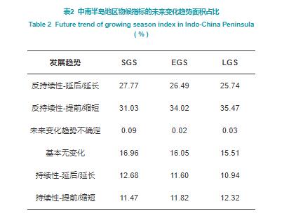
The Indo-China Peninsula lies in a tropical monsoon climate zone and is prone to extreme weather events, including droughts and floods. Against the backdrop of global warming, the frequent occurrences of extreme precipitation affect the typical growth and phenology of vegetation. Based on the Sen+Mann-Kendall method and grey correlation analysis, the temporal and spatial characteristics of vegetation phenology and extreme precipitation in the Indo-China Peninsula and their relationships are analyzed. Vegetation phenological indices are extracted from MCD12Q2 and include the start of the growing season (SGS), the end of the growing season (EGS), and the length of the growing season (LGS). Based on the rescaled range (R/S) analysis, the future trends of these three phenological indices are predicted. The results show the following: 1) Spatial and temporal distribution characteristics: From 2001 to 2018, the SGS and EGS in the eastern region occurred earlier than those in the western region, and LGS was related to vegetation type, lasting approximately 3-7 months in agricultural areas and around 8-9 months in other areas. Excluding the number of rainstorm days (R50), the spatial distribution characteristics of extreme precipitation index were similar to that of annual total precipitation (PRCPTOT), which was higher in the west and lower in the east; 2) Trend: The SGS and EGS show an advanced trend, while the LGS shows a shortened trend; PRCPTOT and daily precipitation intensity had no obvious changes, maximum daily precipitation, extremely heavy rainfall, and R50 show a downward trend, while moderate rain days, heavy rain days and continuous wet days show an upward trend; these demonstrate that the Indo-China Peninsula has fewer extremely strong precipitation events, increased moderate intensity extreme events, and longer duration of rainfall events; 3) Correlation: By comparing the grey correlation degree between phenological indices and extreme precipitation indices, the distribution of the main extreme precipitation indices were obtained and found to have similar and concentrated spatial distribution; the spatial characteristic shows that there was a close relation between vegetation phenology and regional climate; the Indo-China Peninsula is divided into three zones from north to south, and the main controlling factors are the absolute index, the relative index, and the persistence index, respectively; 4) Sustainability: Based on the coupling analysis of H index of phenological indices calculated by R/S method and the Sen+Mann-Kendall method, we found that the future trend of phenological indicators was delayed and opposite to the previous trend in most parts of the Indo-China Peninsula. It is necessary to further study the index system and refine extreme precipitation events to distinguish the effects of different events on vegetation phenology.
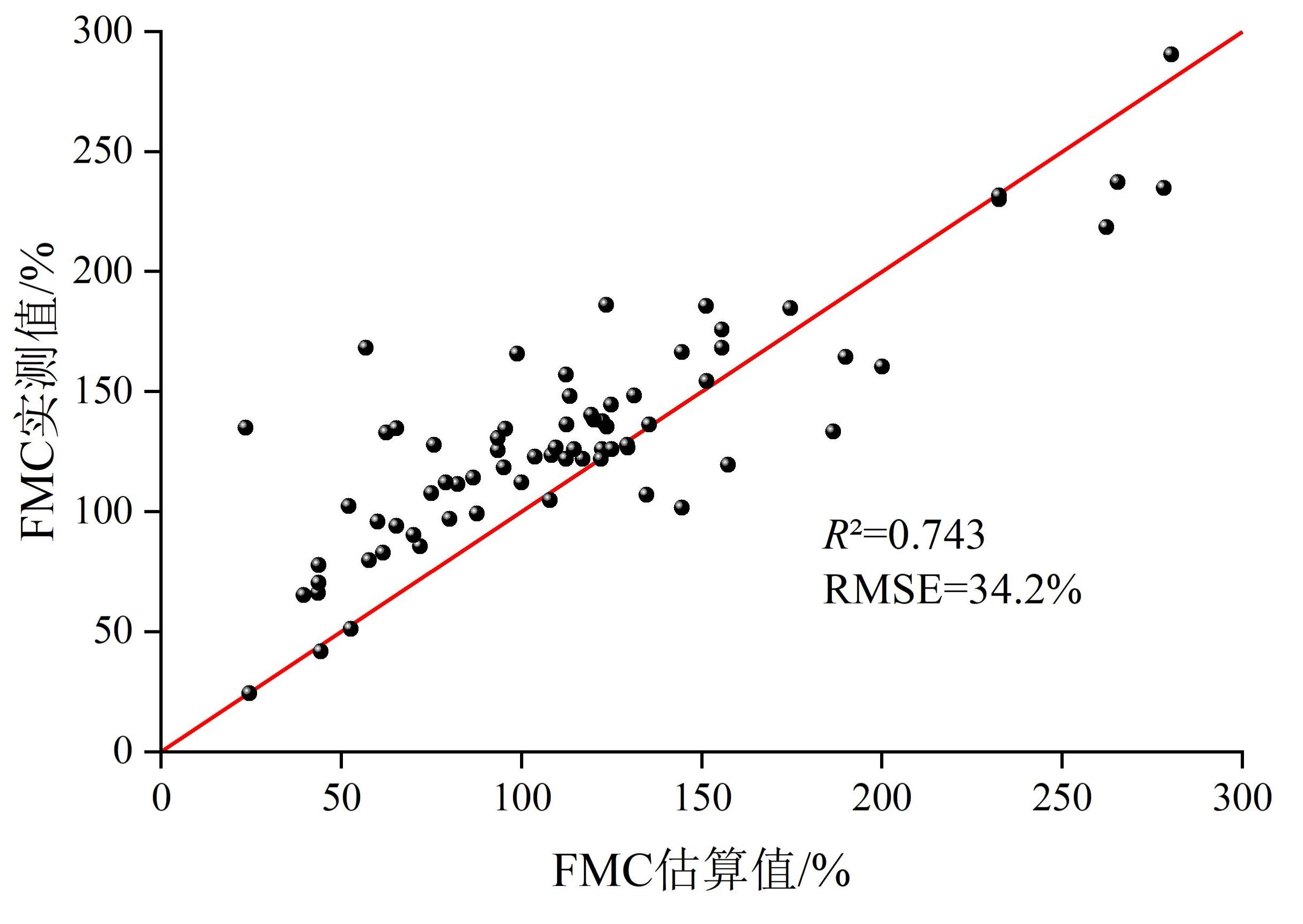
Fuel moisture content (FMC), which is the ratio of equivalent water thickness (EWT) to dry matter content (DMC), plays a crucial role in the estimation of vegetation ignition probability and the fire propagation rate. The PROSAIL model can adequately simulate the canopy reflectance of vegetation, with the input of field-measured data into the model ensuring conformity with the ecological rules. If the EWT and DMC can be estimated by an empirical statistical method according to the reflectance spectrum, the universality of the physical model and the efficiency of the empirical statistical method can be considered. In this study, a fast and versatile method is established for estimating FMC based on the EWT, DMC, leaf area index measured data, and the PROSAIL model. The Normalized Difference Infrared Index (NDII) and Normalized Dry Matter Index (NDMI) were obtained from the spectral curves, with the results showing an obvious linear relationship between the NDII and EWT, NDMI, and DMC. Therefore, EWT and DMC can be estimated using the NDII and NDMI. The accuracy of the estimation results is verified to be high. The estimation model can be extended to Landsat 8 data to estimate FMC. The estimated FMC data verified by the measured data showed that R2 was 0.743 and the RMSE was 34.2%. The model accuracy was reliable owing to large dynamic changes in the FMC. However, the estimated value of the FMC shifted significantly to the left during this study. The reasons for this are as follows: 1) The field-measured points are not sufficient to support the analysis according to different vegetation types, and the physical and chemical properties of different types are varied, leading to altered simulated spectral curves; 2) The vegetation spectrum is sensitive to the DMC at 1,650 nm, 1,720 nm, and 2,270 nm bands, and the sensitivity near the 1,650 nm and 1,720 nm bands is greater than that at 2,270 nm. However, because the Landsat 8 image does not have a 1,720 nm band, the 2,270 nm band was selected to calculate the NDMI, making the value of the estimated DMC too large, resulting in a small value of the estimated FMC and a significant shift to the left; 3) 1,650 nm and 2,270 nm are not in the central wavelength of the two bands of Landsat 8; therefore, the estimated DMC and FMC are shifted. In addition, the fast and versatile method, which is established based on the EWT, DMC, leaf area index measured data and the PROSAIL model, can realize large-scale and high-precision monitoring of the FMC, providing a scientific reference for forest fire prevention.
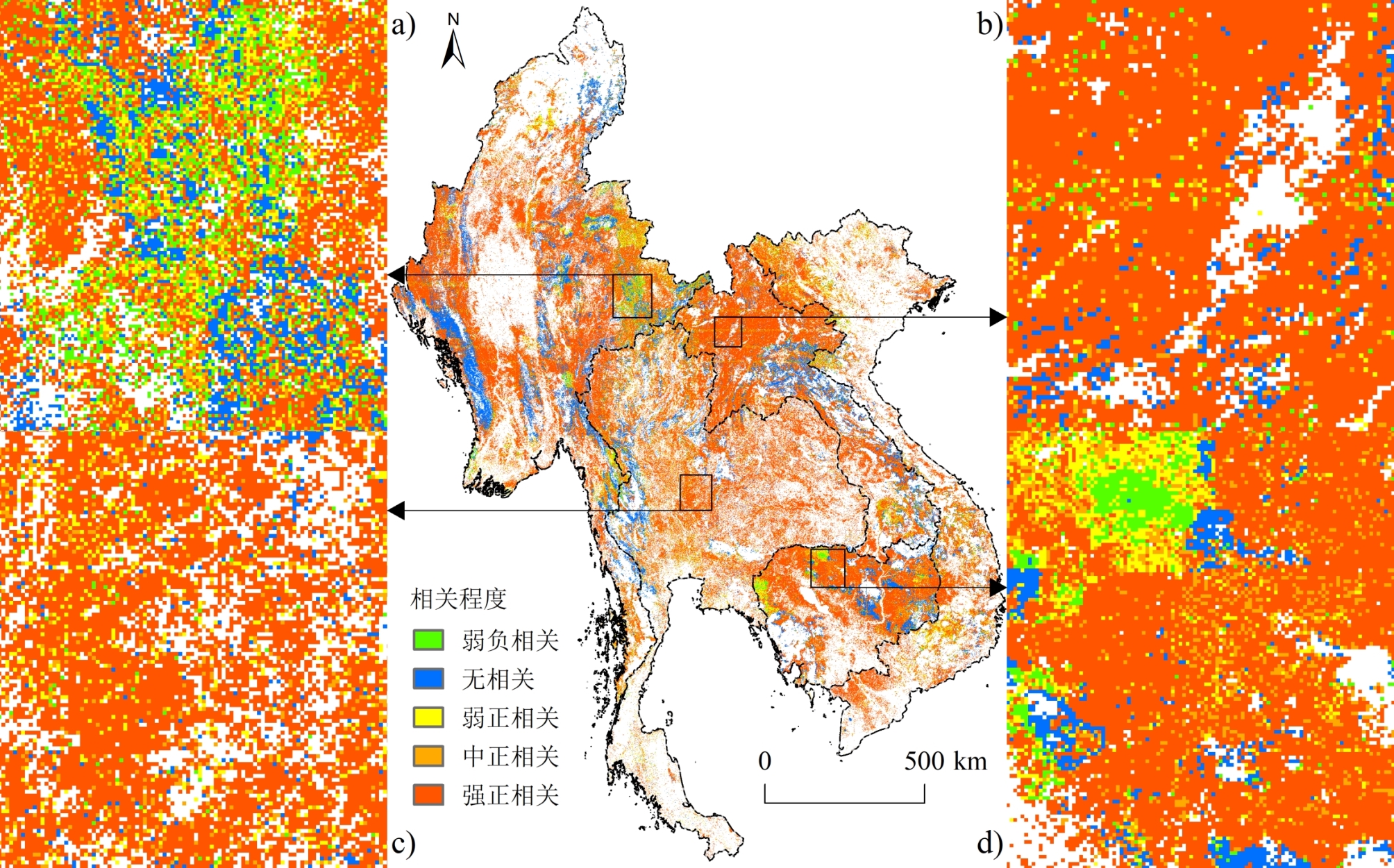
Anthropogenic activities including slashing and burning (or swidden agriculture), illegal logging, and agricultural residue burning, are important drivers and driving mechanisms for the occurrence and development of global active fires especially in the tropics. In the past, limited by the access to the global datasets of gridded population density and consistent active fires, the research on the correlation between the occurrence and development of active fires and human activities was relatively insufficient. It is of great significance to clarify the relationship between human and fire for the sake of revealing the nature of fire regime, estimating carbon emissions and public health management. With Moderate Resolution Imaging Spectroradiometer (MODIS) Collection 6 (C6) active fire products provided by the Fire Information for Resource Management System (FIRMS) and LandScan Global Population Database (e.g., population density) developed by the Department of Energy's Oak Ridge National Laboratory (ORNL) during 2003-2019, the dynamic characteristics of spatial and temporal correlations between occurrence intensity of agricultural and forest active fires and population distribution in Mainland Southeast Asia were quantitatively revealed through GIS-based fishnet (1km) statistical analysis and bivariate spatial correlation. The results show that: (1) Nearly 80% of the "fire-affected grids" in Mainland Southeast Asia were positively correlated with population distribution during the study period. Grids with medium positive correlation and above (r>0.4) accounted for approximately 75%, mainly distributed in areas with low population density (<25 persons/km2) and covered by forest, including central and eastern Thailand, eastern and western Myanmar, northern Laos and northeastern Cambodia. (2) Cropland "fire-affected grids" in Mainland Southeast Asia during 2003-2019 have more population than forest fire-affected grids. More than 90% of the agricultural fire grids and nearly 3/4 of the counterpart of forest fire were positively correlated with population distribution. (3) The grids of strong positive correlation within agricultural fire area were mainly distributed in areas with population density of 25~100 persons/km2, such as southern Myanmar, and central and eastern Thailand. In contrast, the corresponding grids within forest fire area were mostly seen in areas with population density below 25 persons/km2, which include eastern and western Myanmar, northern Laos, and northeastern Cambodia. (4) The correlation between occurrence intensity of agricultural and forest fires and population distribution during 2003-2010 was significantly higher than that during 2011-2019, while the annual average population increased obviously in cropland and forest fire grids in the second period.